|
|
|
0 members (),
2,013
guests, and
21
robots. |
|
Key:
Admin,
Global Mod,
Mod
|
|
S |
M |
T |
W |
T |
F |
S |
|
1
|
2
|
3
|
4
|
5
|
6
|
7
|
|
8
|
9
|
10
|
11
|
12
|
13
|
14
|
|
15
|
16
|
17
|
18
|
19
|
20
|
21
|
|
22
|
23
|
24
|
25
|
26
|
27
|
28
|
|
29
|
30
|
31
|
|
|
|
|
|
There are no members with birthdays on this day. |

#719348
Tue 16 Apr 2024 12:00:AM
|
Joined: Feb 2001
Posts: 381,904
Launch Director
|
OP

Launch Director
Joined: Feb 2001
Posts: 381,904 |
SPC Severe Thunderstorm Watch 111WW 111 SEVERE TSTM NE SD WY 152040Z - 160400Z 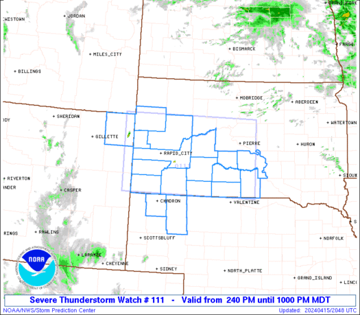
URGENT - IMMEDIATE BROADCAST REQUESTED
Severe Thunderstorm Watch Number 111
NWS Storm Prediction Center Norman OK
240 PM MDT Mon Apr 15 2024

The NWS Storm Prediction Center has issued a

* Severe Thunderstorm Watch for portions of
  Northwest Nebraska
  Western and Southern South Dakota
  Northeast Wyoming

* Effective this Monday afternoon and evening from 240 PM until
  1000 PM MDT.

* Primary threats include...
  Scattered large hail and isolated very large hail events to 2
    inches in diameter likely
  Scattered damaging wind gusts to 70 mph possible
  A tornado or two possible

SUMMARY...Scattered thunderstorms will develop late this afternoon
through the evening from near the Black Hills east-southeastward
into portions of the northern Nebraska and southern South Dakota.
The stronger updrafts that develop will probably evolve into
supercells.  Large hail and severe gusts will be the primary severe
hazards with the stronger storms through the mid to late evening.

The severe thunderstorm watch area is approximately along and 70
statute miles north and south of a line from 65 miles west of Rapid
City SD to 40 miles southeast of Pierre SD. For a complete depiction
of the watch see the associated watch outline update (WOUS64 KWNS
WOU1).

PRECAUTIONARY/PREPAREDNESS ACTIONS...

REMEMBER...A Severe Thunderstorm Watch means conditions are
favorable for severe thunderstorms in and close to the watch area.
Persons in these areas should be on the lookout for threatening
weather conditions and listen for later statements and possible
warnings. Severe thunderstorms can and occasionally do produce
tornadoes.

&&

OTHER WATCH INFORMATION...CONTINUE...WW 109...WW 110...

AVIATION...A few severe thunderstorms with hail surface and aloft to
2 inches. Extreme turbulence and surface wind gusts to 60 knots. A
few cumulonimbi with maximum tops to 500. Mean storm motion vector
24035.

...Smith
Read morehttps://www.spc.noaa.gov/products/watch/ww0111.html
|
|


CMS The Best Conveyancing solicitors conveyancing quotes throughout the UK
For any webhosting enquiries please email webmaster@aus-city.com
|
|
Forums60
Topics766,085
Posts800,839
Members2,958
| |
Most Online17,963
Jan 15th, 2026
|
|
|
|
|
Copyright 1996 - 2026 by David Cottle. Designed by David Bate Jr. All Rights Reserved.
By using this forum, the user agrees not to transfer any data or technical information received under the agreement, to any other entity without the express approval of the AUS-CITY Forum Admins and/or authors of individual posts (Forum Admins and DoD/USSPACECOM for the analysis of satellite tracking data).
Two-line elements (TLE) and all other satellite data presented and distributed via this forum and e-mail lists of AUS-CITY are distributed with permission from DoD/USSTRATCOM.

Reprise Hosting

|

|


 - Click image for larger picture.")


