|
0 members (),
11,945
guests, and
22
robots. |
|
Key:
Admin,
Global Mod,
Mod
|
|
S |
M |
T |
W |
T |
F |
S |
|
|
1
|
2
|
3
|
4
|
5
|
6
|
|
7
|
8
|
9
|
10
|
11
|
12
|
13
|
|
14
|
15
|
16
|
17
|
18
|
19
|
20
|
|
21
|
22
|
23
|
24
|
25
|
26
|
27
|
|
28
|
29
|
30
|
|
|
|
|
|
There are no members with birthdays on this day. |
|
|
|
|
|
|
|
|
by Webmaster - Sat 06 Jun 2026 12:01:AM
|
by Webmaster - Sat 06 Jun 2026 12:01:AM
|
by Webmaster - Sat 06 Jun 2026 12:01:AM
|
|
|
SPC MD 991
by Webmaster - Sat 06 Jun 2026 12:00:AM
|
SPC MD 992
by Webmaster - Sat 06 Jun 2026 12:00:AM
|

Volcano earthquake report for Friday, 5 Jun 2026
• Small magnitude 3.1 earthquake 11 miles southwest of Pukatja, South Austral...
• Moderate mag. 4.2 earthquake - 40 km west of Matias Romero Avendano, Estado...
• World Earthquake Report for Friday, 5 June 2026
• Magnitude 3.8 earthquake strikes near Carlsbad, Eddy County, New Mexico, US...
• Moderate mag. 4.7 earthquake - North Pacific Ocean, 244 km southeast of Hac...
|

#719355
Tue 16 Apr 2024 12:00:AM
|
Joined: Feb 2001
Posts: 381,904
Launch Director
|
OP

Launch Director
Joined: Feb 2001
Posts: 381,904 |
SPC MD 447MD 0447 CONCERNING TORNADO WATCH 110... FOR PARTS OF WESTERN TEXAS INTO FAR SOUTHWEST OK 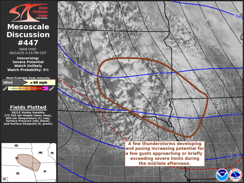
Mesoscale Discussion 0447
NWS Storm Prediction Center Norman OK
0632 PM CDT Mon Apr 15 2024

Areas affected...parts of western Texas into far southwest OK

Concerning...Tornado Watch 110...

Valid 152332Z - 160100Z

The severe weather threat for Tornado Watch 110 continues.

SUMMARY...The severe risk continues. Developing storms across West
TX will remain capable of all hazards this evening. Broad cloud
cover may limit the threat farther east until more robust forcing
arrives from the west.

DISCUSSION...As of 2315 UTC, regional radar and satellite imagery
showed storms finally developing near the dryline over
west/southwest TX. Likely driven by diurnal mixing west of a broad
cirrus plume, these storms have struggled to maintain intensity over
the last hour due to remaining MLCINH. Continued heating west of the
cloud band may allow for additional development into the early
evening as more intense forcing for ascent from the west. The
environment remains capped, but moderately unstable with 2000-2500
J/kg of MLCAPE and dewpoints in the mid to upper 60s F. Strong
deep-layer shear would support supercellular organization with any
storms able to be sustained. Given the moderate buoyancy and shear,
large hail would be likely.

Hi-res guidance suggests more robust development is possible closer
to sunset. Low-level flow is also forecast to increase potentially
increasing the tornado risk with any more sustained supercells that
become established. While uncertain on how much storm
development/coverage will occur in the near-term, the environment
remains favorable for severe weather into this evening.

..Lyons.. 04/15/2024

...Please see www.spc.noaa.gov for graphic product...

ATTN...WFO...FWD...OUN...SJT...LUB...MAF...

LAT...LON   31450127 32240128 32950120 34450037 34679995 34649835
            34479790 33889800 31459964 31090010 31020126 31450127
Read morehttps://www.spc.noaa.gov/products/md/md0447.html
|
|


CMS The Best Conveyancing solicitors conveyancing quotes throughout the UK
For any webhosting enquiries please email webmaster@aus-city.com
|
|
Forums60
Topics779,057
Posts813,852
Members2,960
| |
Most Online22,463
May 9th, 2026
|
|
|


 - Click image for larger picture.")


