|
|
|
0 members (),
1,748
guests, and
19
robots. |
|
Key:
Admin,
Global Mod,
Mod
|
|
S |
M |
T |
W |
T |
F |
S |
|
|
|
|
1
|
2
|
3
|
4
|
|
5
|
6
|
7
|
8
|
9
|
10
|
11
|
|
12
|
13
|
14
|
15
|
16
|
17
|
18
|
|
19
|
20
|
21
|
22
|
23
|
24
|
25
|
|
26
|
27
|
28
|
29
|
30
|
31
|
|
|
There are no members with birthdays on this day. |

Significant magnitude 5.2 earthquake 58 km north of Valparaiso, Chile
• Small earthquake of magnitude 3.7 just reported 10 km southwest of Glogow, ...
• World Earthquake Report for Monday, 6 July 2026
• Significant 5.3 quake hits near Valparaiso, Provincia de Valparaíso, Regio...
• Moderate mag. 4.6 earthquake - South Pacific Ocean, 45 km north of Valparai...
• Strong mag. 5.2 earthquake - South Pacific Ocean, 58 km north of Valparaiso...
|

#740852
Wed 09 Oct 2024 09:55:AM
|
Joined: Feb 2001
Posts: 678,976
Launch Director
|
OP

Launch Director
Joined: Feb 2001
Posts: 678,976 |
Small tremor of magnitude 3.2 just reported 17 km southeast of Mexicali, Mexico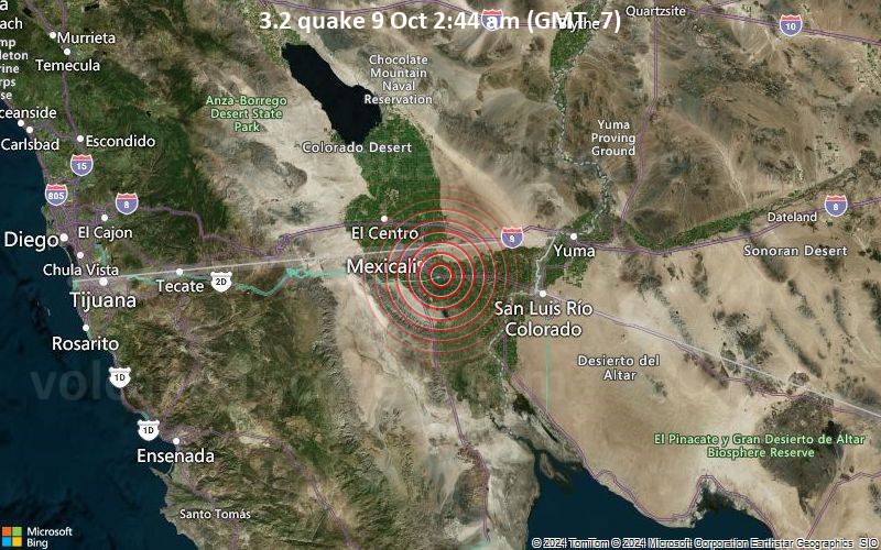 3.2 quake 9 Oct 2:44 am (GMT -7) An earthquake of magnitude 3.2 occurred early morning on Wednesday, October 9th, 2024, at 2:44 am local time near Mexicali, Mexicali Municipality, Baja California, Mexico, as reported by the United States Geological Survey.
According to preliminary data, the quake was located at a shallow depth of 15.9 km. Shallow earthquakes are felt more strongly than deeper ones as they are closer to the surface. The exact magnitude, epicenter, and depth of the quake might be revised within the next few hours or minutes as seismologists review data and refine their calculations, or as other agencies issue their report.
Our monitoring service identified a second report from the European-Mediterranean Seismological Centre (EMSC) which listed the quake at magnitude 3.1.
Towns or cities near the epicenter where the quake might have been felt as very weak shaking include Sesvania (pop. 42) located 1 km from the epicenter, Sinaloa (pop. 2,500) 3 km away, Puebla (pop. 15,200) 6 km away, Mexicali (pop. 1,032,700) 17 km away, Calexico (pop. 40,100) 23 km away, Progreso (pop. 12,600) 28 km away, and Santa Isabel (pop. 29,300) 28 km away. In Guadalupe Victoria (pop. 17,100, 35 km away), El Centro (pop. 44,000, 36 km away), and San Luis Rio Colorado (pop. 158,100, 50 km away), the quake was probably not felt.
Earthquake data: Date & time: Oct 9, 2024 02:44 am (Tijuana time) local time (9 Oct 2024 09:44 GMT)Magnitude: 3.2 Depth: 15.9 km Epicenter latitude / longitude: 32.56°N / 115.29°W  ( Mexicali, Baja California, Mexico) Primary data source: USGShttps://www.volcanodiscovery.com/earthquake/news/254517/Small-tremor-of-magnitude-32-just-reported-17-km-southeast-of-Mexicali-Mexico.html
|
|


CMS The Best Conveyancing solicitors conveyancing quotes throughout the UK
For any webhosting enquiries please email webmaster@aus-city.com
|
|
Forums60
Topics787,116
Posts821,890
Members2,960
| |
Most Online22,463
May 9th, 2026
|
|
|
|
|
Copyright 1996 - 2026 by David Cottle. Designed by David Bate Jr. All Rights Reserved.
By using this forum, the user agrees not to transfer any data or technical information received under this agreement to any other entity without the express approval of the AUS-CITY Forum Admins and/or authors of individual posts (Forum Admins and DoD/USSPACECOM for the analysis of satellite tracking data).
Two-line elements (TLE) and all other satellite data presented and distributed via this forum and AUS-CITY mailing lists are distributed with permission from DoD/USSTRATCOM.

|

|


 - Click image for larger picture.")


