|
|
|
0 members (),
2,736
guests, and
18
robots. |
|
Key:
Admin,
Global Mod,
Mod
|
|
S |
M |
T |
W |
T |
F |
S |
|
1
|
2
|
3
|
4
|
5
|
6
|
7
|
|
8
|
9
|
10
|
11
|
12
|
13
|
14
|
|
15
|
16
|
17
|
18
|
19
|
20
|
21
|
|
22
|
23
|
24
|
25
|
26
|
27
|
28
|
|
29
|
30
|
31
|
|
|
|
|
|
There are no members with birthdays on this day. |

#753564
Sun 09 Feb 2025 12:12:AM
|
Joined: Feb 2001
Posts: 381,904
Launch Director
|
OP

Launch Director
Joined: Feb 2001
Posts: 381,904 |
SPC MD 78MD 0078 CONCERNING WINTER MIXED PRECIPITATION FOR FAR NORTHERN PORTIONS OF THE MID-ATLANTIC AND FAR SOUTHERN PORTIONS OF NEW ENGLAND 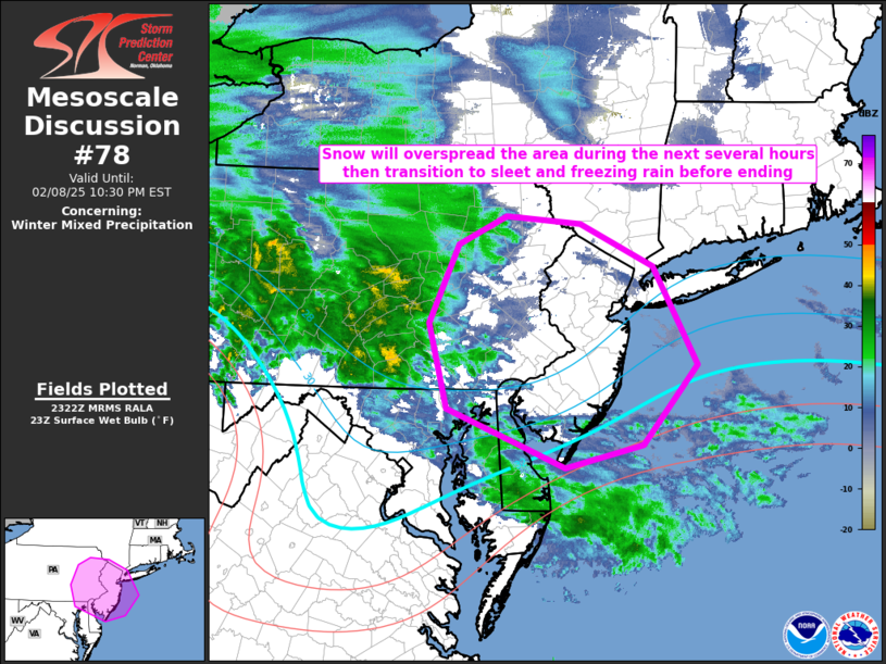
Mesoscale Discussion 0078
NWS Storm Prediction Center Norman OK
0524 PM CST Sat Feb 08 2025

Areas affected...far northern portions of the Mid-Atlantic and far
southern portions of New England

Concerning...Winter mixed precipitation

Valid 082324Z - 090330Z

SUMMARY...Snow should overspread the region in the next few hours.
With time, the snow should transition to sleet and even freezing
rain before ending later this evening/overnight.

DISCUSSION...An area of mixed winter precipitation continues across
western and central Pennsylvania this evening. This precipitation
area developed/is being maintained on the nose of strong low-level
warm-air advection across a deep layer. Over the next few hours this
warm-air advection and associated isentropic ascent will overspread
eastern Pennsylvania and much of New Jersey. Surface temperatures in
the upper-20Fs and low-30Fs, coupled with dewpoint temperatures in
the upper-teens and low-20Fs, yield wet-bulb temperatures below 32F.
Thermal profiles across the region will initially support all snow.
However, as the warm-air advection warms the low-levels, the maximum
temperature in the column should increase above 32F yielding sleet
and potentially eventually freezing rain before precipitation ends
from southwest to northeast.

..Marsh.. 02/08/2025

...Please see www.spc.noaa.gov for graphic product...

ATTN...WFO...OKX...PHI...BGM...CTP...LWX...

LAT...LON   39177553 39527647 40417671 41247631 41547565 41477463
            41017363 39987304 39137378 38907485 39177553
Read morehttps://www.spc.noaa.gov/products/md/md0078.html
|
|


CMS The Best Conveyancing solicitors conveyancing quotes throughout the UK
For any webhosting enquiries please email webmaster@aus-city.com
|
|
Forums60
Topics766,530
Posts801,286
Members2,958
| |
Most Online17,963
Jan 15th, 2026
|
|
|
|
|
Copyright 1996 - 2026 by David Cottle. Designed by David Bate Jr. All Rights Reserved.
By using this forum, the user agrees not to transfer any data or technical information received under the agreement, to any other entity without the express approval of the AUS-CITY Forum Admins and/or authors of individual posts (Forum Admins and DoD/USSPACECOM for the analysis of satellite tracking data).
Two-line elements (TLE) and all other satellite data presented and distributed via this forum and e-mail lists of AUS-CITY are distributed with permission from DoD/USSTRATCOM.

Reprise Hosting

|

|


 - Click image for larger picture.")


