|
|
|
1 members (Alisa),
1,351
guests, and
26
robots. |
|
Key:
Admin,
Global Mod,
Mod
|
|
S |
M |
T |
W |
T |
F |
S |
|
|
1
|
2
|
3
|
4
|
5
|
6
|
|
7
|
8
|
9
|
10
|
11
|
12
|
13
|
|
14
|
15
|
16
|
17
|
18
|
19
|
20
|
|
21
|
22
|
23
|
24
|
25
|
26
|
27
|
|
28
|
29
|
30
|
|
|
|
|
|
There are no members with birthdays on this day. |

Volcano earthquake report for Monday, 29 Jun 2026
• World Earthquake Report for Monday, 29 June 2026
• Moderate mag. 4.8 earthquake - South of the Fiji Islands on Tuesday, Jun 30...
• Magnitude 4.0 earthquake strikes near Kodiak, Kodiak Island, Alaska, USA
• Light mag. 3.9 earthquake - 51 km NNE of Aleneva, Alaska, on Monday, Jun 29...
• Moderate mag. 4.2 earthquake - Northern Molucca Sea on Monday, Jun 29, 2026...
|

#793747
Mon 19 Jan 2026 02:22:AM
|
Joined: Feb 2001
Posts: 678,976
Launch Director
|
OP

Launch Director
Joined: Feb 2001
Posts: 678,976 |
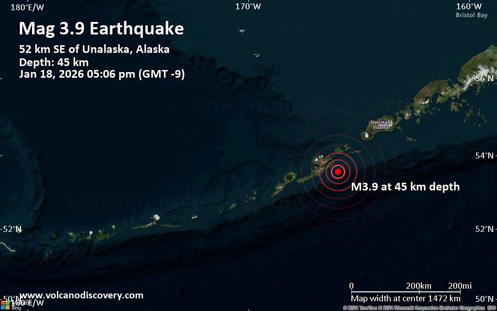
Small magnitude 3.9 earthquake 32 miles southeast of Unalaska, Alaska, United StatesAn earthquake of magnitude 3.9 occurred in the afternoon on Sunday, January 18th, 2026, at 5:06 pm local time near Unalaska, Aleutians West, Alaska, USA, as reported by the United States Geological Survey.
According to preliminary data, the quake was located at a moderately shallow depth of 28 miles. The exact magnitude, epicenter, and depth of the quake might be revised within the next few hours or minutes as seismologists review data and refine their calculations, or as other agencies issue their report.
Our monitoring service identified a second report from the European-Mediterranean Seismological Centre (EMSC) which listed the quake at magnitude 3.9 as well.
Towns or cities near the epicenter where the quake might have been felt as very weak shaking include Unalaska (pop. 4,500) located 32 miles from the epicenter, Dutch Harbor (pop. 4,400) 33 miles away, and Akutan (pop. 1000) 40 miles away.
Earthquake data: Date & time: Jan 19, 2026 02:06 am (Universal Time) local time (19 Jan 2026 02:06 GMT)Magnitude: 3.9 Depth: 44.86 km Epicenter latitude / longitude: 53.56°N / 165.94°W  (Aleutians West, Alaska, United States) Primary data source: USGShttps://www.volcanodiscovery.com/earthquake/news/292297/Small-magnitude-39-earthquake-32-miles-southeast-of-Unalaska-Alaska-United-States.html
|
|


CMS The Best Conveyancing solicitors conveyancing quotes throughout the UK
For any webhosting enquiries please email webmaster@aus-city.com
|
|
Forums60
Topics785,011
Posts819,779
Members2,960
| |
Most Online22,463
May 9th, 2026
|
|
|
|
|
Copyright 1996 - 2026 by David Cottle. Designed by David Bate Jr. All Rights Reserved.
By using this forum, the user agrees not to transfer any data or technical information received under this agreement to any other entity without the express approval of the AUS-CITY Forum Admins and/or authors of individual posts (Forum Admins and DoD/USSPACECOM for the analysis of satellite tracking data).
Two-line elements (TLE) and all other satellite data presented and distributed via this forum and AUS-CITY mailing lists are distributed with permission from DoD/USSTRATCOM.

|

|


 - Click image for larger picture.")


