|
|
|
1 members (Webmaster),
2,555
guests, and
6
robots. |
|
Key:
Admin,
Global Mod,
Mod
|
|
S |
M |
T |
W |
T |
F |
S |
|
|
|
|
|
|
1
|
2
|
|
3
|
4
|
5
|
6
|
7
|
8
|
9
|
|
10
|
11
|
12
|
13
|
14
|
15
|
16
|
|
17
|
18
|
19
|
20
|
21
|
22
|
23
|
|
24
|
25
|
26
|
27
|
28
|
29
|
30
|
|
31
|
|
|
|
|
|
|
|
There are no members with birthdays on this day. |
|
|
|
|
SPC MD 653
by Webmaster - Wed 06 May 2026 05:44:PM
|
|
|
|
|
|
|
|
|
|
|
|
|
|
|

#795468
Mon 26 Jan 2026 07:50:PM
|
Joined: Feb 2001
Posts: 381,904
Launch Director
|
OP

Launch Director
Joined: Feb 2001
Posts: 381,904 |
Volcano earthquake report for Monday, 26 Jan 2026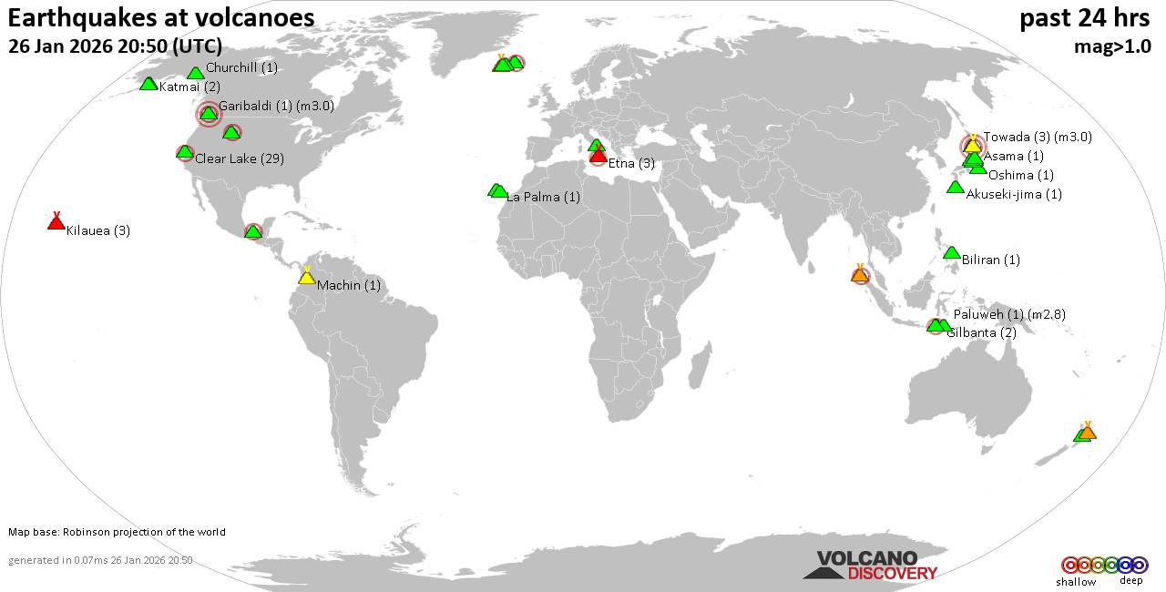 World map showing volcanoes with shallow (less than 50 km) earthquakes within 20 km radius during the past 24 hours on 26 Jan 2026 Number in brackets indicate nr of quakes. Quakes detected near: Akuseki-jima (1 quake mag 1.3), Asama (1 quake mag 1.0), Bardarbunga (2 quakes between mag 0.5-2.1), Biliran (1 quake mag 1.5), Churchill (1 quake mag 1.2), Clear Lake (27 quakes between mag 0.6-2.0)
El Chichón (2 quakes between mag 2.5-2.5), Eldey (2 quakes between mag 2.4-2.9), Etna (2 quakes between mag 1.9-2.1), Garibaldi (1 quake mag 3.0), Gilbanta (2 quakes between mag 2.2-2.4), Hakkoda (1 quake mag 3.0), Hiuchi (2 quakes between mag 0.8-1.1), Hrómundartindur (5 quakes between mag 0.8-1.6), Katmai (2 quakes between mag 0.9-1.1), Kilauea (4 quakes between mag 0.9-1.7), Krísuvík (3 quakes between mag 0.5-1.5), La Palma (1 quake mag 1.6), Machin (1 quake mag 1.3), Mageik (3 quakes between mag 0.1-1.6), Maroa (5 quakes between mag 1.5-2.0), Myoko (2 quakes between mag 0.4-1.9), Numazawa (1 quake mag 2.1), Oshima (1 quake mag 1.0), Paluweh (1 quake mag 2.8), Sangeang Api (1 quake mag 2.1), Tenerife (15 quakes between mag 0.5-2.1), Towada (3 quakes between mag 3.0-3.0), Vesuvius (2 quakes between mag 1.3-1.8), White Island (1 quake mag 2.7), Yellowstone (9 quakes between mag 0.0-2.1) (updated 19h50)
Note: Earthquakes within 20 km from and at depths less than 50 km under active volcanoes are reported. The list is not complete because many volcanoes are not monitored and/or seismic data in high resolution is not available publicly.
Volcanoes with recent earthquakes above magnitude 2 or more than 10 quakes are listed below:
Bardarbunga volcano (Iceland): 2 earthquakes up to magnitude 2.12 earthquakes occurred near (under) the volcano during 6 minutes, the last being recorded quake 17 hours ago. Hypocenter depths ranged between 3.00 and 1.40 km. Earthquake details: 2.1 quake 5.9 km E of Bárðarbunga Jan 26, 2026 03:07 am (Universal Time) (6 km E) 0.5 quake Iceland: 6.1 km ESE of Bárðarbunga Jan 26, 2026 03:12 am (Reykjavik time) (6 km E) All earthquakes at BardarbungaClear Lake volcano (California): 27 earthquakes up to magnitude 2.0Possible earthquake swarm: 27 earthquakes occurred near (under) the volcano during 21 hours, the last being recorded quake 2 hours ago. Hypocenter depths ranged between 11.30 and 0.94 km. Earthquake details: (only 5 largest) 2.0 quake Sonoma County, 13 mi southwest of Clearlake, Lake County, California, United States, Jan 25, 2026 10:25 pm (GMT -8) (16 km SSW) 1.6 quake Sonoma County, 13 mi southwest of Clearlake, Lake County, California, United States, Jan 25, 2026 06:59 pm (GMT -8) (17 km S) 1.4 quake 27 mi north of Santa Rosa, Sonoma County, California, United States, Jan 26, 2026 02:02 am (GMT -8) (17 km S) 1.4 quake 27 mi north of Santa Rosa, Sonoma County, California, United States, Jan 26, 2026 07:45 am (GMT -8) (18 km SSW) 1.3 quake 28 mi north of Santa Rosa, Sonoma County, California, United States, Jan 25, 2026 10:31 pm (GMT -8) (16 km SSW) All earthquakes at Clear LakeEl Chichón volcano (Southern Mexico): 2 earthquakes up to magnitude 2.52 earthquakes occurred near (under) the volcano during 63 seconds, the last being recorded quake 22 hours ago. Hypocenter depths ranged between 3.00 and 3.00 km. Earthquake details: 2.5 quake Estado de Chiapas, 29 km southwest of Teapa, Estado de Tabasco, Mexico, Jan 25, 2026 04:09 pm (GMT -6) (7 km NE) 2.5 quake Estado de Chiapas, 30 km southwest of Teapa, Estado de Tabasco, Mexico, Jan 25, 2026 04:10 pm (GMT -6) (7 km ENE) All earthquakes at El ChichónEldey volcano (Iceland): 2 earthquakes up to magnitude 2.92 earthquakes occurred near (under) the volcano during 8 hours, the last being recorded quake 25 minutes ago. Hypocenter depths ranged between 10.20 and 9.60 km. Earthquake details: 2.9 quake Irminger Sea, 89 km southwest of Reykjavik, Capital Region, Iceland, Jan 26, 2026 11:31 am (Reykjavik time) (19 km WSW) 2.4 quake Iceland: 3.3 km NW of Eldey Jan 26, 2026 07:24 pm (Reykjavik time) (3 km N) All earthquakes at EldeyEldey is located at the beginning of the Reykjanes Ridge off the SW tip of Iceland. Its highest elevation is the top of Eldey Island, but most of the volcanic edifice is submerged. Several eruptions occurred in historic times, last in 1926. Etna volcano (Italy): 2 earthquakes up to magnitude 2.12 earthquakes occurred near (under) the volcano during 7 hours, the last being recorded quake 4 hours ago. Hypocenter depths ranged between 13.08 and 9.40 km. Earthquake details: 2.1 quake 7.7 km north of Adrano, Catania, Sicily, Italy, Jan 26, 2026 09:45 am (GMT +1) (17 km W) 1.9 quake 8.6 km north of Adrano, Catania, Sicily, Italy, Jan 26, 2026 05:02 pm (GMT +1) (16 km W) All earthquakes at EtnaGaribaldi volcano (Canada): magnitude 3.0 earthquakeA magnitude 3.0 earthquake occurred at the volcano 13 hours ago. The quake, which might be volcanic in origin, was located at a depth of 10.00 km depth at 17 km distance SW from the volcano. Earthquake details: Reported quake or seismic-like event: 3.4 km north of Squamish, Squamish-Lillooetal, British Columbia, Canada, Jan 25, 2026 10:58 pm (GMT -8) (17 km SW) All earthquakes at GaribaldiGilbanta volcano (Lesser Sunda Islands): 2 earthquakes up to magnitude 2.42 earthquakes occurred near (under) the volcano during 3 hours, the last being recorded quake 17 hours ago. Hypocenter depths ranged between 15.00 and 14.00 km. Earthquake details: 2.4 quake Flores Sea, 5.7 km north of Gili Banta Island, West Nusa Tenggara, Indonesia, Jan 26, 2026 10:32 am (GMT +8) (6 km NW) 2.2 quake Flores Sea, 14 km north of Gili Banta Island, West Nusa Tenggara, Indonesia, Jan 26, 2026 07:13 am (GMT +8) (12 km N) All earthquakes at GilbantaHakkoda volcano (Honshu): magnitude 3.0 earthquakeA magnitude 3.0 earthquake occurred at the volcano 16 hours ago. The quake, which might be volcanic in origin, was located at a depth of 10.00 km depth at 10 km distance S from the volcano. Earthquake details: Reported quake or seismic-like event: 31 km southeast of Aomori, Aomori, Japan, Jan 26, 2026 12:25 pm (GMT +9) (10 km S) All earthquakes at HakkodaNumazawa volcano (Honshu): magnitude 2.1 earthquakeA magnitude 2.1 earthquake occurred at the volcano 15 hours ago. The quake, which might be volcanic in origin, was located at a depth of 7.10 km depth at 19 km distance ESE from the volcano. Earthquake details: 2.1 quake 3.7 km southwest of Aizu-misato Machi, Fukushima, Japan, Jan 26, 2026 02:17 pm (GMT +9) (19 km ESE) All earthquakes at NumazawaPaluweh volcano (Lesser Sunda Islands): magnitude 2.8 earthquakeA magnitude 2.8 earthquake occurred at the volcano 22 hours ago. The quake, which might be volcanic in origin, was located at a depth of 13.00 km depth at 10 km distance SSE from the volcano. Earthquake details: 2.8 quake Kabupaten Sikka, 50 km north of Ende, Indonesia, Jan 26, 2026 06:02 am (GMT +8) (10 km SSE) All earthquakes at PaluwehSangeang Api volcano (Lesser Sunda Islands): magnitude 2.1 earthquakeA magnitude 2.1 earthquake occurred at the volcano 19 hours ago. The quake, which might be volcanic in origin, was located at a depth of 36.00 km depth at 17 km distance NNW from the volcano. Earthquake details: 2.1 quake Flores Sea, 16 km north of Pulau Sangeang Island, West Nusa Tenggara, Indonesia, Jan 26, 2026 09:13 am (GMT +8) (17 km NNW) All earthquakes at Sangeang ApiTenerife volcano (Canary Islands): 15 earthquakes up to magnitude 2.1Possible earthquake swarm: 15 earthquakes occurred near (under) the volcano during 16 hours, the last being recorded quake 3 hours ago. Hypocenter depths ranged between 31.80 and 10.00 km. Earthquake details: (only 5 largest) 2.1 quake 9.9 km north of Arona, Santa Cruz de Tenerife, Canary Islands, Spain, Jan 26, 2026 07:54 am (Universal Time) (11 km SSW) 1.5 quake 17 km north of Arona, Santa Cruz de Tenerife, Canary Islands, Spain, Jan 26, 2026 07:53 am (Universal Time) (3 km SSE) 1.5 quake 14 km north of Arona, Santa Cruz de Tenerife, Canary Islands, Spain, Jan 26, 2026 07:52 am (Universal Time) (6 km SW) 1.3 quake 16 km north of Arona, Santa Cruz de Tenerife, Canary Islands, Spain, Jan 26, 2026 01:43 pm (Universal Time) (5 km SW) 1.3 quake 16 km north of Arona, Santa Cruz de Tenerife, Canary Islands, Spain, Jan 26, 2026 05:05 pm (Universal Time) (6 km SW) All earthquakes at TenerifeTowada volcano (Honshu): 3 earthquakes up to magnitude 3.03 earthquakes occurred near (under) the volcano during 12 hours, the last being recorded quake 4 hours ago. Hypocenter depths ranged between 10.00 and 10.00 km. Earthquake details: Unconfirmed earthquake or seismic-like event: 35 km southeast of Tagajo-shi, Miyagi, Japan, Jan 27, 2026 12:48 am (GMT +9) (10 km S) Uncertain quake: M3.0, 106 km northwest of Ajigasawa, Aomori, Japan, Jan 26, 2026 06:27 pm (GMT +9) (10 km WNW) Reported seismic-like event (likely no quake): 41 km northeast of Odate, Akita, Japan, Jan 26, 2026 12:46 pm (GMT +9) (8 km NNW) All earthquakes at TowadaWhite Island volcano (New Zealand): magnitude 2.7 earthquakeA magnitude 2.7 earthquake occurred at the volcano 9 hours ago. The quake, which might be volcanic in origin, was located at a depth of 25.50 km depth at 16 km distance N from the volcano. Earthquake details: 2.7 quake South Pacific Ocean, 67 km north of Whakatane, Bay of Plenty, New Zealand, Jan 26, 2026 11:56 pm (GMT +13) (16 km N) All earthquakes at White IslandYellowstone volcano (Wyoming ): 9 earthquakes up to magnitude 2.19 earthquakes occurred near (under) the volcano during 6 hours, the last being recorded quake 4 hours ago. Hypocenter depths ranged between 11.16 and 2.91 km. Earthquake details: (only 5 largest) 2.1 quake Teton County, Wyoming, 21 mi east of West Yellowstone, Gallatin County, Montana, United States, Jan 26, 2026 05:31 am (GMT -7) (19 km N) 2.1 quake Teton County, Wyoming, 21 mi east of West Yellowstone, Gallatin County, Montana, United States, Jan 26, 2026 04:37 am (GMT -7) (19 km N) 1.3 quake Teton County, Wyoming, 21 mi east of West Yellowstone, Gallatin County, Montana, United States, Jan 26, 2026 06:23 am (GMT -7) (18 km N) 1.2 quake Teton County, Wyoming, 21 mi east of West Yellowstone, Gallatin County, Montana, United States, Jan 26, 2026 02:52 am (GMT -7) (19 km N) 1.1 quake Teton County, Wyoming, 21 mi east of West Yellowstone, Gallatin County, Montana, United States, Jan 26, 2026 08:44 am (GMT -7) (19 km N) All earthquakes at Yellowstonehttps://www.volcanodiscovery.com/earthquakes-volcanoes/news/292937/Volcano-earthquake-report-for-Monday-26-Jan-2026.html
|
|


CMS The Best Conveyancing solicitors conveyancing quotes throughout the UK
For any webhosting enquiries please email webmaster@aus-city.com
|
|
Forums60
Topics771,841
Posts806,629
Members2,958
| |
Most Online17,963
Jan 15th, 2026
|
|
|
|
|
Copyright 1996 - 2026 by David Cottle. Designed by David Bate Jr. All Rights Reserved.
By using this forum, the user agrees not to transfer any data or technical information received under the agreement, to any other entity without the express approval of the AUS-CITY Forum Admins and/or authors of individual posts (Forum Admins and DoD/USSPACECOM for the analysis of satellite tracking data).
Two-line elements (TLE) and all other satellite data presented and distributed via this forum and e-mail lists of AUS-CITY are distributed with permission from DoD/USSTRATCOM.

Reprise Hosting

|

|


 - Click image for larger picture.")


