|
|
|
0 members (),
6,451
guests, and
25
robots. |
|
Key:
Admin,
Global Mod,
Mod
|
|
S |
M |
T |
W |
T |
F |
S |
|
1
|
2
|
3
|
4
|
5
|
6
|
7
|
|
8
|
9
|
10
|
11
|
12
|
13
|
14
|
|
15
|
16
|
17
|
18
|
19
|
20
|
21
|
|
22
|
23
|
24
|
25
|
26
|
27
|
28
|
|
There are no members with birthdays on this day. |
|
|
Joined: Feb 2001
Posts: 381,904
Launch Director
|
OP

Launch Director
Joined: Feb 2001
Posts: 381,904 |
Volcano earthquake report for Monday, 16 Feb 2026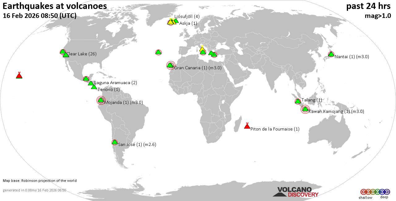 World map showing volcanoes with shallow (less than 50 km) earthquakes within 20 km radius during the past 24 hours on 16 Feb 2026 Number in brackets indicate nr of quakes. Quakes detected near: Bardarbunga (3 quakes between mag 0.2-2.2), Brennisteinsfjöll (16 quakes between mag 0.1-1.8), Campi Flegrei (Phlegrean Fields) (5 quakes between mag 0.1-1.5), Chaîne des Puys (1 quake mag 1.3), Clear Lake (24 quakes between mag 0.2-2.5), Coso (2 quakes between mag 0.4-1.2)
El Chichón (23 quakes between mag 1.2-2.7), Eldey (3 quakes between mag 0.9-1.1), Fantale (1 quake mag 4.4), Fayal (1 quake mag 2.2), Geureudong (1 quake mag 2.7), Gran Canaria (1 quake mag 3.0), Katla (5 quakes between mag 0.0-1.3), Kawah Kamojang (1 quake mag 3.0), Kilauea (2 quakes between mag 1.9-1.9), Kolumbo (1 quake mag 2.2), Laguna Aramuaca (6 quakes between mag 1.6-2.7), Lipari (1 quake mag 2.2), Ljósufjöll (4 quakes between mag 0.7-1.0), Lopevi (1 quake mag 4.1), Michoacán-Guanajuato (1 quake mag 3.1), Salton Buttes (2 quakes between mag 1.1-2.0), Snowy Mountain (2 quakes between mag 1.0-1.4), Sousaki (1 quake mag 2.2), Talang (1 quake mag 2.3), Tenerife (5 quakes between mag 0.7-1.5), Tenorio (1 quake mag 1.9), Tjörnes Fracture Zone (14 quakes between mag 0.0-1.7), Vatnafjöll (1 quake mag 1.3), Yantarni (1 quake mag 2.6) (updated 15h50)
Note: Earthquakes within 20 km from and at depths less than 50 km under active volcanoes are reported. The list is not complete because many volcanoes are not monitored and/or seismic data in high resolution is not available publicly.
Volcanoes with recent earthquakes above magnitude 2 or more than 10 quakes are listed below:
Bardarbunga volcano (Iceland): 3 earthquakes up to magnitude 2.23 earthquakes occurred near (under) the volcano during 16 hours, the last being recorded quake 3 hours ago. Hypocenter depths ranged between 17.10 and 0.00 km. Earthquake details: 2.2 quake 4.9 km NE of Bárðarbunga Feb 16, 2026 12:23 pm (Universal Time) (6 km NE) 0.3 quake Iceland: 17.5 km ESE of Bárðarbunga Feb 15, 2026 08:38 pm (Reykjavik time) (17 km ESE) 0.2 quake Iceland: 17.3 km E of Bárðarbunga Feb 15, 2026 08:36 pm (Reykjavik time) (17 km E) All earthquakes at BardarbungaBrennisteinsfjöll volcano (Reykjanes Peninsula, Iceland): 16 earthquakes up to magnitude 1.8Possible earthquake swarm: 16 earthquakes occurred near (under) the volcano during 23 hours, the last being recorded quake 22 minutes ago. Hypocenter depths ranged between 6.80 and 0.00 km. Earthquake details: (only 5 largest) 1.8 quake 3.7 km E of Helgafell Feb 16, 2026 09:09 am (Universal Time) (11 km NNE) 1.6 quake 10.0 km S of Helgafell Feb 16, 2026 09:43 am (Universal Time) (1 km E) 1.1 quake Iceland: 3.6 km E of Helgafell Feb 16, 2026 09:10 am (Reykjavik time) (11 km NNE) 1.0 quake Iceland: 6.8 km SSW of Helgafell Feb 16, 2026 01:27 am (Reykjavik time) (6 km NW) 0.8 quake 5.2 km SW of Helgafell Feb 16, 2026 03:14 pm (Universal Time) (9 km NW) All earthquakes at BrennisteinsfjöllClear Lake volcano (California): 24 earthquakes up to magnitude 2.5Possible earthquake swarm: 24 earthquakes occurred near (under) the volcano during 24 hours, the last being recorded quake 24 minutes ago. Hypocenter depths ranged between 3.94 and 0.06 km. Earthquake details: (only 5 largest) 2.5 quake 26 mi north of Santa Rosa, Sonoma County, California, United States, Feb 15, 2026 01:04 pm (GMT -8) (18 km SSW) 1.5 quake 28 mi north of Santa Rosa, Sonoma County, California, United States, Feb 15, 2026 09:10 am (GMT -8) (16 km SSW) 1.2 quake 27 mi north of Santa Rosa, Sonoma County, California, United States, Feb 15, 2026 11:16 am (GMT -8) (17 km S) 1.1 quake Lake County, 27 mi north of Santa Rosa, Sonoma County, California, United States, Feb 15, 2026 12:08 pm (GMT -8) (16 km S) 1.1 quake 25 mi north of Santa Rosa, Sonoma County, California, United States, Feb 15, 2026 12:12 pm (GMT -8) (19 km S) All earthquakes at Clear LakeEl Chichón volcano (Southern Mexico): 23 earthquakes up to magnitude 2.7Possible earthquake swarm: 23 earthquakes occurred near (under) the volcano during 18 hours, the last being recorded quake 6 hours ago. Hypocenter depths ranged between 3.00 and 1.40 km. Earthquake details: (only 5 largest) 2.7 quake Estado de Chiapas, 37 km southwest of Teapa, Estado de Tabasco, Mexico, Feb 15, 2026 10:29 pm (GMT -6) (1 km NW) 2.6 quake Estado de Chiapas, 37 km southwest of Teapa, Estado de Tabasco, Mexico, Feb 15, 2026 10:46 pm (GMT -6) (0 km SW) 2.5 quake Estado de Chiapas, 36 km southwest of Teapa, Estado de Tabasco, Mexico, Feb 15, 2026 11:04 am (GMT -6) (1 km N) 2.5 quake Estado de Chiapas, 36 km southwest of Teapa, Estado de Tabasco, Mexico, Feb 15, 2026 08:09 pm (GMT -6) (2 km NNW) 2.5 quake Estado de Chiapas, 37 km southwest of Teapa, Estado de Tabasco, Mexico, Feb 15, 2026 08:24 pm (GMT -6) (1 km NW) All earthquakes at El ChichónFantale volcano (Ethiopia): magnitude 4.4 earthquakeA magnitude 4.4 earthquake occurred at the volcano 20 hours ago. The quake, which might be volcanic in origin, was located at a depth of 10.00 km depth at 17 km distance NNW from the volcano. Earthquake details: 4.4 quake Harari Region, 24 km north of Metahara, Oromiya, Ethiopia, Feb 15, 2026 10:39 pm (GMT +3) (17 km NNW) All earthquakes at FantaleFayal volcano (Azores): magnitude 2.2 earthquakeA magnitude 2.2 earthquake occurred at the volcano 14 hours ago. The quake, which might be volcanic in origin, was located at a depth of 4.50 km depth at 13 km distance SW from the volcano. Earthquake details: 2.2 quake North Atlantic Ocean, 19 km west of Ribeira Grande, Azores, Portugal, Feb 16, 2026 12:49 am (GMT -1) (13 km SW) All earthquakes at FayalGeureudong volcano (Sumatra): magnitude 2.7 earthquakeA magnitude 2.7 earthquake occurred at the volcano 22 minutes ago. The quake, which might be volcanic in origin, was located at a depth of 11.00 km depth at 16 km distance N from the volcano. Earthquake details: 2.7 quake Kabupaten Aceh Utara, 46 km southwest of Lhokseumawe, Indonesia, Feb 16, 2026 10:28 pm (GMT +7) (16 km N) All earthquakes at GeureudongGran Canaria volcano (Canary Islands): magnitude 3.0 earthquakeA magnitude 3.0 earthquake occurred at the volcano 18 hours ago. The quake, which might be volcanic in origin, was located at a depth of 10.00 km depth at 11 km distance NW from the volcano. Earthquake details: Reported seismic-like event (likely no quake): 29 km west of Las Palmas de Gran Canaria, Las Palmas, Canary Islands, Spain, Feb 15, 2026 09:27 pm (GMT +0) (11 km NW) All earthquakes at Gran CanariaKawah Kamojang volcano (West Java): magnitude 3.0 earthquakeA magnitude 3.0 earthquake occurred at the volcano 24 hours ago. The quake, which might be volcanic in origin, was located at a depth of 10.00 km depth at 19 km distance WNW from the volcano. Earthquake details: Reported seismic-like event (likely no quake): 17 km south of Bandung, Kota Bandung, Jawa Barat, Indonesia, Feb 15, 2026 10:57 pm (GMT +7) (19 km WNW) All earthquakes at Kawah KamojangKolumbo volcano (Greece): magnitude 2.2 earthquakeA magnitude 2.2 earthquake occurred at the volcano 17 hours ago. The quake, which might be volcanic in origin, was located at a depth of 5.00 km depth at 8 km distance NE from the volcano. Earthquake details: 2.2 quake Aegean Sea, 20 km northeast of Santorini Island, Greece, Feb 16, 2026 12:43 am (GMT +2) (8 km NE) All earthquakes at KolumboLaguna Aramuaca volcano (El Salvador): 6 earthquakes up to magnitude 2.76 earthquakes occurred near (under) the volcano during 5 hours, the last being recorded quake 3 hours ago. Hypocenter depths ranged between 7.00 and 5.00 km. Earthquake details: (only 5 largest) 2.7 quake 20 km southeast of San Miguel, Departamento de San Miguel, El Salvador, Feb 16, 2026 07:09 am (GMT -6) (12 km S) 2.4 quake 21 km southeast of San Miguel, Departamento de San Miguel, El Salvador, Feb 16, 2026 05:11 am (GMT -6) (13 km S) 2.0 quake 21 km southeast of San Miguel, Departamento de San Miguel, El Salvador, Feb 16, 2026 05:30 am (GMT -6) (14 km S) 1.8 quake 21 km south of San Miguel, Departamento de San Miguel, El Salvador, Feb 16, 2026 01:59 am (GMT -6) (14 km S) 1.7 quake 23 km south of San Miguel, Departamento de San Miguel, El Salvador, Feb 16, 2026 04:05 am (GMT -6) (15 km S) All earthquakes at Laguna AramuacaLipari volcano (Eolian Islands): magnitude 2.2 earthquakeA magnitude 2.2 earthquake occurred at the volcano 23 hours ago. The quake, which might be volcanic in origin, was located at a depth of 7.50 km depth at 16 km distance W from the volcano. Earthquake details: 2.2 quake Tyrrhenian Sea, 11 km southwest of Isola Salina Island, Sicily, Italy, Feb 15, 2026 06:15 pm (GMT +1) (16 km W) All earthquakes at LipariLopevi volcano (Vanuatu): magnitude 4.1 earthquakeA magnitude 4.1 earthquake occurred at the volcano 4 hours ago. The quake, which might be volcanic in origin, was located at a depth of 1.00 km depth at 17 km distance NE from the volcano. Earthquake details: 4.1 quake Coral Sea, 16 km northeast of Lopevi Island, Malampa Province, Vanuatu, Feb 16, 2026 11:05 pm (GMT +11) (17 km NE) All earthquakes at LopeviMichoacán-Guanajuato volcano (Western & Central Mexico): magnitude 3.1 earthquakeA magnitude 3.1 earthquake occurred at the volcano 11 hours ago. The quake, which might be volcanic in origin, was located at a depth of 19.60 km depth at 12 km distance SW from the volcano. Earthquake details: 3.1 quake 30 km west of Uruapan, Estado de Michoacan de Ocampo, Mexico, Feb 15, 2026 10:42 pm (GMT -6) (12 km SW) All earthquakes at Michoacán-GuanajuatoSousaki volcano (Greece): magnitude 2.2 earthquakeA magnitude 2.2 earthquake occurred at the volcano 22 hours ago. The quake, which might be volcanic in origin, was located at a depth of 10.00 km depth at 11 km distance N from the volcano. Earthquake details: 2.2 quake 16 km northeast of Corinth, Nomos Korinthias, Peloponnese, Greece, Feb 15, 2026 07:47 pm (GMT +2) (11 km N) All earthquakes at SousakiTalang volcano (Sumatra): magnitude 2.3 earthquakeA magnitude 2.3 earthquake occurred at the volcano 12 hours ago. The quake, which might be volcanic in origin, was located at a depth of 3.00 km depth at 1 km distance N from the volcano. Earthquake details: 2.3 quake Kabupaten Solok, 19 km south of Solok, Indonesia, Feb 16, 2026 10:32 am (GMT +7) (1 km N) All earthquakes at TalangTjörnes Fracture Zone volcano (Iceland): 14 earthquakes up to magnitude 1.7Possible earthquake swarm: 14 earthquakes occurred near (under) the volcano during 16 hours, the last being recorded quake 2 hours ago. Hypocenter depths ranged between 13.30 and 0.00 km. Earthquake details: (only 5 largest) 1.7 quake 36.3 km WNW of Kópasker Feb 16, 2026 10:25 am (Universal Time) (16 km NNW) 1.5 quake 35.7 km WNW of Kópasker Feb 16, 2026 10:55 am (Universal Time) (14 km NNW) 1.4 quake Iceland: 36.4 km ESE of Grímsey Feb 16, 2026 10:43 am (Reykjavik time) (17 km NNW) 1.3 quake 36.3 km WNW of Kópasker Feb 16, 2026 10:27 am (Universal Time) (15 km NNW) 1.2 quake 35.7 km WNW of Kópasker Feb 16, 2026 12:55 pm (Universal Time) (14 km NNW) All earthquakes at Tjörnes Fracture ZoneYantarni volcano (Alaska Peninsula): magnitude 2.6 earthquakeA magnitude 2.6 earthquake occurred at the volcano 4 hours ago. The quake, which might be volcanic in origin, was located at a depth of 3.80 km depth at 18 km distance W from the volcano. Earthquake details: 2.6 quake 38 mi south of Pilot Point, Lake and Peninsula Borough, Alaska, United States, Feb 16, 2026 02:49 am (GMT -9) (18 km W) All earthquakes at Yantarnihttps://www.volcanodiscovery.com/earthquakes-volcanoes/news/295009/Volcano-earthquake-report-for-Monday-16-Feb-2026.html
|
|


CMS The Best Conveyancing solicitors conveyancing quotes throughout the UK
For any webhosting enquiries please email webmaster@aus-city.com
|
|
Forums60
Topics761,856
Posts796,585
Members2,957
| |
Most Online17,963
Jan 15th, 2026
|
|
|
|
|
Copyright 1996 - 2026 by David Cottle. Designed by David Bate Jr. All Rights Reserved.
By using this forum, the user agrees not to transfer any data or technical information received under the agreement, to any other entity without the express approval of the AUS-CITY Forum Admins and/or authors of individual posts (Forum Admins and DoD/USSPACECOM for the analysis of satellite tracking data).
Two-line elements (TLE) and all other satellite data presented and distributed via this forum and e-mail lists of AUS-CITY are distributed with permission from DoD/USSTRATCOM.

Reprise Hosting

|

|


 - Click image for larger picture.")


