|
|
|
0 members (),
1,716
guests, and
22
robots. |
|
Key:
Admin,
Global Mod,
Mod
|
|
S |
M |
T |
W |
T |
F |
S |
|
1
|
2
|
3
|
4
|
5
|
6
|
7
|
|
8
|
9
|
10
|
11
|
12
|
13
|
14
|
|
15
|
16
|
17
|
18
|
19
|
20
|
21
|
|
22
|
23
|
24
|
25
|
26
|
27
|
28
|
|
29
|
30
|
31
|
|
|
|
|
|
There are no members with birthdays on this day. |
|
|
Joined: Feb 2001
Posts: 381,904
Launch Director
|
OP

Launch Director
Joined: Feb 2001
Posts: 381,904 |
SPC Tornado Watch 16WW 16 TORNADO IA KS MO NE 062115Z - 070400Z 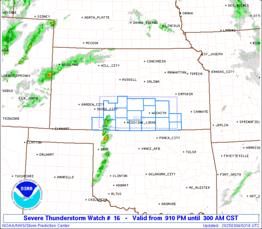
URGENT - IMMEDIATE BROADCAST REQUESTED
Tornado Watch Number 16
NWS Storm Prediction Center Norman OK
315 PM CST Fri Mar 6 2026

The NWS Storm Prediction Center has issued a

* Tornado Watch for portions of
  Western and Central Iowa
  Central and Northeast Kansas
  Northwest Missouri
  Southeast Nebraska

* Effective this Friday afternoon and evening from 315 PM until
  1000 PM CST.

* Primary threats include...
  A few tornadoes and a couple intense tornadoes possible
  Scattered large hail likely with isolated very large hail events
    to 2 inches in diameter possible
  Scattered damaging wind gusts to 70 mph possible

SUMMARY...Severe storms are expected to develop near a
northeast/southwest-oriented cold front, with additional development
possible into this evening ahead of it. All aspects of severe
weather are possible including large hail, damaging winds, and
tornado potential.

The tornado watch area is approximately along and 65 statute miles
north and south of a line from 35 miles south southwest of Russell
KS to 50 miles south southeast of Fort Dodge IA. For a complete
depiction of the watch see the associated watch outline update
(WOUS64 KWNS WOU6).

PRECAUTIONARY/PREPAREDNESS ACTIONS...

REMEMBER...A Tornado Watch means conditions are favorable for
tornadoes and severe thunderstorms in and close to the watch
area. Persons in these areas should be on the lookout for
threatening weather conditions and listen for later statements
and possible warnings.

&&

OTHER WATCH INFORMATION...CONTINUE...WW 15...

AVIATION...Tornadoes and a few severe thunderstorms with hail
surface and aloft to 2 inches. Extreme turbulence and surface wind
gusts to 60 knots. A few cumulonimbi with maximum tops to 450. Mean
storm motion vector 23030.

...Guyer
Read morehttps://www.spc.noaa.gov/products/watch/ww0016.html
|
|


CMS The Best Conveyancing solicitors conveyancing quotes throughout the UK
For any webhosting enquiries please email webmaster@aus-city.com
|
|
Forums60
Topics764,708
Posts799,456
Members2,958
| |
Most Online17,963
Jan 15th, 2026
|
|
|
|
|
Copyright 1996 - 2026 by David Cottle. Designed by David Bate Jr. All Rights Reserved.
By using this forum, the user agrees not to transfer any data or technical information received under the agreement, to any other entity without the express approval of the AUS-CITY Forum Admins and/or authors of individual posts (Forum Admins and DoD/USSPACECOM for the analysis of satellite tracking data).
Two-line elements (TLE) and all other satellite data presented and distributed via this forum and e-mail lists of AUS-CITY are distributed with permission from DoD/USSTRATCOM.

Reprise Hosting

|

|


 - Click image for larger picture.")


