|
|
|
0 members (),
3,652
guests, and
22
robots. |
|
Key:
Admin,
Global Mod,
Mod
|
|
S |
M |
T |
W |
T |
F |
S |
|
|
|
|
1
|
2
|
3
|
4
|
|
5
|
6
|
7
|
8
|
9
|
10
|
11
|
|
12
|
13
|
14
|
15
|
16
|
17
|
18
|
|
19
|
20
|
21
|
22
|
23
|
24
|
25
|
|
26
|
27
|
28
|
29
|
30
|
|
|
|
There are no members with birthdays on this day. |
|
|
Joined: Feb 2001
Posts: 381,904
Launch Director
|
OP

Launch Director
Joined: Feb 2001
Posts: 381,904 |
Volcano earthquake report for Thursday, 16 Apr 2026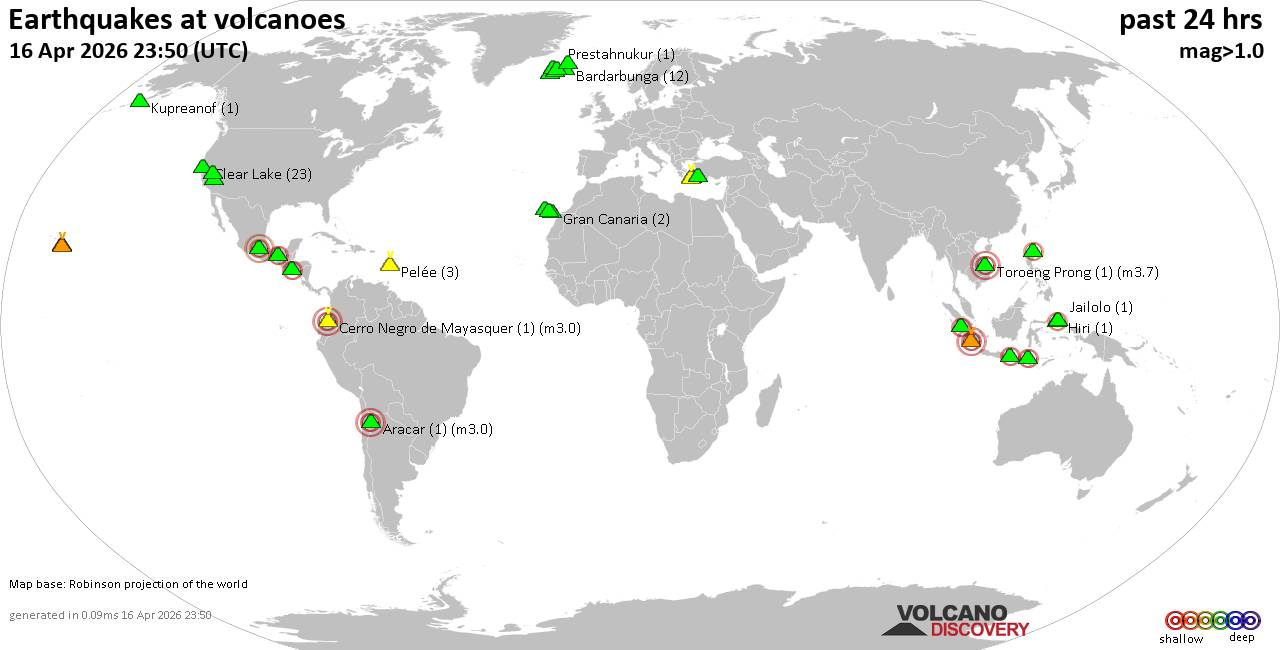 World map showing volcanoes with shallow (less than 50 km) earthquakes within 20 km radius during the past 24 hours on 16 Apr 2026 Number in brackets indicate nr of quakes. Quakes detected near: Baluran (3 quakes between mag 2.6-3.0), Clear Lake (31 quakes between mag 0.2-1.7), Davidof (1 quake mag 1.1), El Chichón (2 quakes between mag 2.1-2.2), Eldey (8 quakes between mag 0.6-1.3), Etna (1 quake mag 1.2)
Gran Canaria (1 quake mag 1.6), Hulubelu (2 quakes between mag 2.0-2.5), Iliboleng (1 quake mag 2.0), Kenger (1 quake mag 1.4), Kilauea (4 quakes between mag 1.4-1.9), Kolumbo (2 quakes between mag 1.8-2.1), Korovin (1 quake mag 1.2), Krísuvík (7 quakes between mag 0.0-1.4), La Palma (1 quake mag 1.6), Ljósufjöll (1 quake mag 1.9), Maunaloa (1 quake mag 1.6), Methana (1 quake mag 1.3), Muria (1 quake mag 2.4), Nemrut Dagi (1 quake mag 1.2), Newberry (1 quake mag 1.7), Patah (1 quake mag 3.3), Pelée (14 quakes between mag 0.2-1.5), Raung (1 quake mag 2.6), Taupo (1 quake mag 2.4), Tenerife (4 quakes between mag 0.9-1.4), Tjörnes Fracture Zone (5 quakes between mag 0.7-2.0), Vulcano (1 quake mag 1.8) (updated 04h50)
Note: Earthquakes within 20 km from and at depths less than 50 km under active volcanoes are reported. The list is not complete because many volcanoes are not monitored and/or seismic data in high resolution is not available publicly.
Volcanoes with recent earthquakes above magnitude 2 or more than 10 quakes are listed below:
Baluran volcano (East Java): 3 earthquakes up to magnitude 3.03 earthquakes occurred near (under) the volcano during 6 hours, the last being recorded quake 8 hours ago. Hypocenter depths ranged between 9.00 and 5.00 km. Earthquake details: 3.0 quake 16 km northwest of Wongsorejo, Kabupaten Banyuwangi, Jawa Timur, Indonesia, Apr 16, 2026 04:00 am (GMT +7) (9 km WSW) 2.6 quake Kabupaten Situbondo, 13 km north of Wongsorejo, Indonesia, Apr 15, 2026 09:49 pm (GMT +7) (4 km SSE) 2.6 quake Kabupaten Situbondo, 17 km north of Wongsorejo, Indonesia, Apr 15, 2026 10:04 pm (GMT +7) (2 km NE) All earthquakes at BaluranClear Lake volcano (California): 31 earthquakes up to magnitude 1.7Possible earthquake swarm: 31 earthquakes occurred near (under) the volcano during 23 hours, the last being recorded quake 34 minutes ago. Hypocenter depths ranged between 12.55 and 0.68 km. Earthquake details: (only 5 largest) 1.7 quake Sonoma County, 14 mi southwest of Clearlake, Lake County, California, United States, Apr 15, 2026 08:18 pm (GMT -7) (17 km SSW) 1.7 quake Sonoma County, 14 mi southwest of Clearlake, Lake County, California, United States, Apr 15, 2026 12:44 pm (GMT -7) (16 km SSW) 1.5 quake 26 mi north of Santa Rosa, Sonoma County, California, United States, Apr 15, 2026 07:25 pm (GMT -7) (18 km S) 1.3 quake Lake County, 28 mi north of Santa Rosa, Sonoma County, California, United States, Apr 15, 2026 01:00 pm (GMT -7) (15 km S) 1.3 quake 26 mi north of Santa Rosa, Sonoma County, California, United States, Apr 15, 2026 07:50 pm (GMT -7) (18 km S) All earthquakes at Clear LakeEl Chichón volcano (Southern Mexico): 2 earthquakes up to magnitude 2.22 earthquakes occurred near (under) the volcano during 13 hours, the last being recorded quake 9 hours ago. Hypocenter depths ranged between 3.00 and 3.00 km. Earthquake details: 2.2 quake Estado de Chiapas, 35 km southwest of Teapa, Estado de Tabasco, Mexico, Apr 15, 2026 12:53 am (GMT -6) (2 km E) 2.1 quake Estado de Chiapas, 36 km southwest of Teapa, Estado de Tabasco, Mexico, Apr 15, 2026 01:45 pm (GMT -6) (1 km ESE) All earthquakes at El ChichónHulubelu volcano (Sumatra): 2 earthquakes up to magnitude 2.52 earthquakes occurred near (under) the volcano during 9 hours, the last being recorded quake 13 hours ago. Hypocenter depths ranged between 4.00 and 3.00 km. Earthquake details: 2.5 quake Kabupaten Tanggamus, 73 km west of Bandar Lampung, Indonesia, Apr 15, 2026 02:11 pm (GMT +7) (4 km SE) 2.0 quake Kabupaten Tanggamus, 76 km west of Bandar Lampung, Indonesia, Apr 15, 2026 10:41 pm (GMT +7) (8 km NNE) All earthquakes at HulubeluKolumbo volcano (Greece): 2 earthquakes up to magnitude 2.12 earthquakes occurred near (under) the volcano during 18 hours, the last being recorded quake 4 hours ago. Hypocenter depths ranged between 13.40 and 8.60 km. Earthquake details: 2.1 quake Aegean Sea, 28 km northeast of Santorini Island, Greece, Apr 16, 2026 03:26 am (GMT +3) (16 km NE) 1.8 quake Aegean Sea, 24 km northeast of Santorini Island, Greece, Apr 15, 2026 09:18 am (GMT +3) (13 km NE) All earthquakes at KolumboMuria volcano (Central Java): magnitude 2.4 earthquakeA magnitude 2.4 earthquake occurred at the volcano 15 hours ago. The quake, which might be volcanic in origin, was located at a depth of 6.00 km depth at 10 km distance WSW from the volcano. Earthquake details: 2.4 quake 10.7 km northeast of Pecangaan, Indonesia, Apr 15, 2026 08:27 pm (GMT +7) (10 km WSW) All earthquakes at MuriaPatah volcano (Sumatra): magnitude 3.3 earthquakeA magnitude 3.3 earthquake occurred at the volcano 8 hours ago. The quake, which might be volcanic in origin, was located at a depth of 4.00 km depth at 16 km distance NNE from the volcano. Earthquake details: 3.3 quake Kota Pagar Alam, 15 km southeast of Pagar Alam, Indonesia, Apr 16, 2026 03:22 am (GMT +7) (16 km NNE) All earthquakes at PatahPelée volcano (Caribbean): 14 earthquakes up to magnitude 1.5Possible earthquake swarm: 14 earthquakes occurred near (under) the volcano during 14 hours, the last being recorded quake 9 hours ago. Hypocenter depths ranged between 0.38 and 0.00 km. Earthquake details: (only 5 largest) 1.5 quake 25 km northwest of Fort-de-France, Martinique, Apr 15, 2026 03:56 am (GMT -4) (1 km S) 1.1 quake 25 km northwest of Fort-de-France, Martinique, Apr 15, 2026 02:27 am (GMT -4) (1 km S) 0.9 quake 25 km northwest of Fort-de-France, Martinique, Apr 15, 2026 03:55 am (GMT -4) (1 km SSE) 0.8 quake 25 km northwest of Fort-de-France, Martinique, Apr 15, 2026 08:23 am (GMT -4) (1 km SSE) 0.8 quake 26 km northwest of Fort-de-France, Martinique, Apr 15, 2026 03:55 am (GMT -4) (1 km S) All earthquakes at PeléeRaung volcano (East Java): magnitude 2.6 earthquakeA magnitude 2.6 earthquake occurred at the volcano 15 hours ago. The quake, which might be volcanic in origin, was located at a depth of 8.00 km depth at 13 km distance NW from the volcano. Earthquake details: 2.6 quake 21 km southeast of Bondowoso, Kabupaten Bondowoso, Jawa Timur, Indonesia, Apr 15, 2026 08:46 pm (GMT +7) (13 km NW) All earthquakes at RaungTaupo volcano (New Zealand): magnitude 2.4 earthquakeA magnitude 2.4 earthquake occurred at the volcano 23 hours ago. The quake, which might be volcanic in origin, was located at a depth of 5.00 km depth at 19 km distance NNE from the volcano. Earthquake details: 2.4 quake 2.5 km north of Taupo, Waikato, New Zealand, Apr 15, 2026 05:41 pm (GMT +12) (19 km NNE) All earthquakes at Taupohttps://www.volcanodiscovery.com/earthquakes-volcanoes/news/300044/Volcano-earthquake-report-for-Thursday-16-Apr-2026.html
|
|


CMS The Best Conveyancing solicitors conveyancing quotes throughout the UK
For any webhosting enquiries please email webmaster@aus-city.com
|
|
Forums60
Topics769,099
Posts803,866
Members2,958
| |
Most Online17,963
Jan 15th, 2026
|
|
|
|
|
Copyright 1996 - 2026 by David Cottle. Designed by David Bate Jr. All Rights Reserved.
By using this forum, the user agrees not to transfer any data or technical information received under the agreement, to any other entity without the express approval of the AUS-CITY Forum Admins and/or authors of individual posts (Forum Admins and DoD/USSPACECOM for the analysis of satellite tracking data).
Two-line elements (TLE) and all other satellite data presented and distributed via this forum and e-mail lists of AUS-CITY are distributed with permission from DoD/USSTRATCOM.

Reprise Hosting

|

|


 - Click image for larger picture.")


