|
|
|
0 members (),
828
guests, and
26
robots. |
|
Key:
Admin,
Global Mod,
Mod
|
|
S |
M |
T |
W |
T |
F |
S |
|
|
|
|
1
|
2
|
3
|
4
|
|
5
|
6
|
7
|
8
|
9
|
10
|
11
|
|
12
|
13
|
14
|
15
|
16
|
17
|
18
|
|
19
|
20
|
21
|
22
|
23
|
24
|
25
|
|
26
|
27
|
28
|
29
|
30
|
|
|
|
There are no members with birthdays on this day. |

#805803
Tue 14 Apr 2026 11:50:PM
|
Joined: Feb 2001
Posts: 381,904
Launch Director
|
OP

Launch Director
Joined: Feb 2001
Posts: 381,904 |
Volcano earthquake report for Tuesday, 14 Apr 2026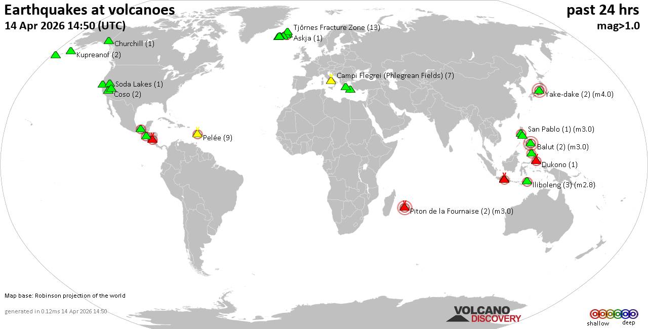 World map showing volcanoes with shallow (less than 50 km) earthquakes within 20 km radius during the past 24 hours on 14 Apr 2026 Number in brackets indicate nr of quakes. Quakes detected near: Apaneca Range (1 quake mag 2.3), Askja (2 quakes between mag 1.0-1.3), Bardarbunga (2 quakes between mag 0.1-2.1), Brennisteinsfjöll (13 quakes between mag 0.1-1.5), Cabalian (1 quake mag 3.0), Campi Flegrei (Phlegrean Fields) (5 quakes between mag 0.1-1.0)
Clear Lake (26 quakes between mag 0.3-1.8), Coso (3 quakes between mag 0.3-1.8), Davidof (2 quakes between mag 0.8-1.0), Dukono (1 quake mag 2.2), El Chichón (4 quakes between mag 2.3-2.8), Eldey (3 quakes between mag 0.8-1.7), Grímsvötn (3 quakes between mag 0.1-1.1), Hulubelu (1 quake mag 2.0), Iliboleng (3 quakes between mag 2.2-2.8), Katla (1 quake mag 1.9), Kilauea (1 quake mag 2.0), Krísuvík (9 quakes between mag 0.0-1.0), Kupreanof (2 quakes between mag 2.0-2.0), Long Valley (1 quake mag 1.3), Masaya (1 quake mag 2.0), Mayotte Island (1 quake mag 1.4), Morne Plat Pays (1 quake mag 1.1), Pelée (21 quakes between mag 0.1-2.5), Piton de la Fournaise (1 quake mag 3.0), Salton Buttes (3 quakes between mag 1.1-1.6), Soda Lakes (1 quake mag 1.6), Sousaki (1 quake mag 1.4), Stepovak Bay 4 (1 quake mag 1.8), Tenerife (2 quakes between mag 1.4-1.4), Tindfjallajökull (2 quakes between mag 0.6-1.0), Torfajökull (2 quakes between mag 0.6-1.4), Yake-dake (2 quakes between mag 3.3-4.0) (updated 23h50)
Note: Earthquakes within 20 km from and at depths less than 50 km under active volcanoes are reported. The list is not complete because many volcanoes are not monitored and/or seismic data in high resolution is not available publicly.
Volcanoes with recent earthquakes above magnitude 2 or more than 10 quakes are listed below:
Apaneca Range volcano (El Salvador): magnitude 2.3 earthquakeA magnitude 2.3 earthquake occurred at the volcano 17 hours ago. The quake, which might be volcanic in origin, was located at a depth of 7.00 km depth at 4 km distance WSW from the volcano. Earthquake details: 2.3 quake 6.2 km southeast of Ahuachapan, Departamento de Ahuachapan, El Salvador, Apr 14, 2026 12:21 am (GMT -6) (4 km WSW) All earthquakes at Apaneca RangeBardarbunga volcano (Iceland): 2 earthquakes up to magnitude 2.12 earthquakes occurred near (under) the volcano during 41 minutes, the last being recorded quake 17 hours ago. Hypocenter depths ranged between 7.60 and 0.70 km. Earthquake details: 2.1 quake 5.1 km ESE of Bárðarbunga Apr 14, 2026 06:30 am (Universal Time) (5 km E) 0.1 quake 2.7 km E of Bárðarbunga Apr 14, 2026 05:49 am (Universal Time) (3 km ENE) All earthquakes at BardarbungaBrennisteinsfjöll volcano (Reykjanes Peninsula, Iceland): 13 earthquakes up to magnitude 1.5Possible earthquake swarm: 13 earthquakes occurred near (under) the volcano during 11 hours, the last being recorded quake 4 hours ago. Hypocenter depths ranged between 8.10 and 0.00 km. Earthquake details: (only 5 largest) 1.5 quake 6.2 km SE of Bláfjallaskáli Apr 14, 2026 09:08 am (Universal Time) (14 km ENE) 1.1 quake 6.6 km SE of Bláfjallaskáli Apr 14, 2026 06:41 pm (Universal Time) (14 km E) 1.0 quake 7.0 km SE of Bláfjallaskáli Apr 14, 2026 12:01 pm (Universal Time) (14 km E) 1.0 quake 7.0 km SE of Bláfjallaskáli Apr 14, 2026 09:05 am (Universal Time) (14 km E) 1.0 quake Iceland: 7.3 km S of Bláfjallaskáli Apr 14, 2026 09:09 am (Reykjavik time) (10 km E) All earthquakes at BrennisteinsfjöllCabalian volcano (Central Philippines): magnitude 3.0 earthquakeA magnitude 3.0 earthquake occurred at the volcano 19 hours ago. The quake, which might be volcanic in origin, was located at a depth of 10.00 km depth at 8 km distance N from the volcano. Earthquake details: Reported seismic-like event (likely no quake): 27 km east of Sogod, Province of Southern Leyte, Eastern Visayas, Philippines, Apr 14, 2026 12:27 pm (GMT +8) (8 km N) All earthquakes at CabalianClear Lake volcano (California): 26 earthquakes up to magnitude 1.8Possible earthquake swarm: 26 earthquakes occurred near (under) the volcano during 23 hours, the last being recorded quake 26 minutes ago. Hypocenter depths ranged between 3.53 and 0.68 km. Earthquake details: (only 5 largest) 1.8 quake 12 mi southwest of Clearlake, Lake County, California, United States, Apr 13, 2026 08:30 pm (GMT -7) (17 km S) 1.3 quake 26 mi north of Santa Rosa, Sonoma County, California, United States, Apr 14, 2026 02:06 am (GMT -7) (18 km S) 1.3 quake 27 mi north of Santa Rosa, Sonoma County, California, United States, Apr 14, 2026 05:05 am (GMT -7) (18 km SSW) 1.2 quake 25 mi north of Santa Rosa, Sonoma County, California, United States, Apr 13, 2026 08:36 pm (GMT -7) (19 km S) 1.1 quake 26 mi north of Santa Rosa, Sonoma County, California, United States, Apr 13, 2026 05:50 pm (GMT -7) (17 km S) All earthquakes at Clear LakeDukono volcano (Halmahera): magnitude 2.2 earthquakeA magnitude 2.2 earthquake occurred at the volcano 12 hours ago. The quake, which might be volcanic in origin, was located at a depth of 8.00 km depth at 7 km distance WSW from the volcano. Earthquake details: 2.2 quake 22 km west of Tobelo, Kabupaten Halmahera Utara, North Maluku, Indonesia, Apr 14, 2026 09:14 pm (GMT +9) (7 km WSW) All earthquakes at DukonoEl Chichón volcano (Southern Mexico): 4 earthquakes up to magnitude 2.84 earthquakes occurred near (under) the volcano during 9 hours, the last being recorded quake 14 hours ago. Hypocenter depths ranged between 3.70 and 2.20 km. Earthquake details: 2.8 quake Estado de Chiapas, 36 km southwest of Teapa, Estado de Tabasco, Mexico, Apr 13, 2026 06:11 pm (GMT -6) (2 km ESE) 2.5 quake Estado de Chiapas, 37 km southwest of Teapa, Estado de Tabasco, Mexico, Apr 14, 2026 01:26 am (GMT -6) (1 km WSW) 2.3 quake Estado de Chiapas, 36 km southwest of Teapa, Estado de Tabasco, Mexico, Apr 13, 2026 08:12 pm (GMT -6) (1 km N) 2.3 quake Estado de Chiapas, 38 km southwest of Teapa, Estado de Tabasco, Mexico, Apr 14, 2026 03:31 am (GMT -6) (3 km SSE) All earthquakes at El ChichónIliboleng volcano (Lesser Sunda Islands): 3 earthquakes up to magnitude 2.83 earthquakes occurred near (under) the volcano during 7 hours, the last being recorded quake 10 hours ago. Hypocenter depths ranged between 15.00 and 3.00 km. Earthquake details: 2.8 quake Kabupaten Flores Timur, 32 km west of Lewoleba, Indonesia, Apr 14, 2026 03:01 pm (GMT +8) (18 km SW) 2.4 quake Kabupaten Flores Timur, 32 km west of Lewoleba, Indonesia, Apr 14, 2026 02:50 pm (GMT +8) (19 km SW) 2.2 quake Kabupaten Flores Timur, 29 km west of Lewoleba, Indonesia, Apr 14, 2026 09:58 pm (GMT +8) (17 km SW) All earthquakes at IlibolengPelée volcano (Caribbean): 21 earthquakes up to magnitude 2.5Possible earthquake swarm: 21 earthquakes occurred near (under) the volcano during 12 hours, the last being recorded quake 5 hours ago. Hypocenter depths ranged between 2.80 and 0.08 km. Earthquake details: (only 5 largest) 2.5 quake 26 km northwest of Fort-de-France, Martinique, Apr 14, 2026 09:59 am (GMT -4) (1 km SSW) 1.7 quake 26 km northwest of Fort-de-France, Martinique, Apr 14, 2026 09:43 am (GMT -4) (0 km SSW) 1.4 quake 26 km northwest of Fort-de-France, Martinique, Apr 14, 2026 09:09 am (GMT -4) (1 km SSW) 1.1 quake 26 km northwest of Fort-de-France, Martinique, Apr 14, 2026 08:34 am (GMT -4) (1 km SSW) 1.0 quake 26 km northwest of Fort-de-France, Martinique, Apr 14, 2026 10:33 am (GMT -4) (1 km WSW) All earthquakes at PeléePiton de la Fournaise volcano (Indian Ocean): magnitude 3.0 earthquakeA magnitude 3.0 earthquake occurred at the volcano 19 hours ago. The quake, which might be volcanic in origin, was located at a depth of 10.00 km depth at 19 km distance WSW from the volcano. Earthquake details: Reported seismic-like event (likely no quake): 8.4 km northeast of Saint-Pierre, Reunion, Apr 14, 2026 08:46 am (GMT +4) (19 km WSW) All earthquakes at Piton de la FournaiseYake-dake volcano (Honshu): 2 earthquakes up to magnitude 4.02 earthquakes occurred near (under) the volcano during 1 hour 18 minutes, the last being recorded quake 16 hours ago. Hypocenter depths ranged between 0 and 0.00 km. Earthquake details: 4.0 quake 36 km northeast of Takayama, Gifu, Japan, Apr 14, 2026 03:34 pm (GMT +9) (9 km N) 3.3 quake Gifu, 26 km west of Azumino, Nagano, Japan, Apr 14, 2026 04:52 pm (GMT +9) (9 km N) All earthquakes at Yake-dakehttps://www.volcanodiscovery.com/earthquakes-volcanoes/news/299901/Volcano-earthquake-report-for-Tuesday-14-Apr-2026.html
|
|


CMS The Best Conveyancing solicitors conveyancing quotes throughout the UK
For any webhosting enquiries please email webmaster@aus-city.com
|
|
Forums60
Topics769,168
Posts803,935
Members2,958
| |
Most Online17,963
Jan 15th, 2026
|
|
|
|
|
Copyright 1996 - 2026 by David Cottle. Designed by David Bate Jr. All Rights Reserved.
By using this forum, the user agrees not to transfer any data or technical information received under the agreement, to any other entity without the express approval of the AUS-CITY Forum Admins and/or authors of individual posts (Forum Admins and DoD/USSPACECOM for the analysis of satellite tracking data).
Two-line elements (TLE) and all other satellite data presented and distributed via this forum and e-mail lists of AUS-CITY are distributed with permission from DoD/USSTRATCOM.

Reprise Hosting

|

|


 - Click image for larger picture.")


