|
0 members (),
2,743
guests, and
25
robots. |
|
Key:
Admin,
Global Mod,
Mod
|
|
S |
M |
T |
W |
T |
F |
S |
|
|
1
|
2
|
3
|
4
|
5
|
6
|
|
7
|
8
|
9
|
10
|
11
|
12
|
13
|
|
14
|
15
|
16
|
17
|
18
|
19
|
20
|
|
21
|
22
|
23
|
24
|
25
|
26
|
27
|
|
28
|
29
|
30
|
|
|
|
|
|
There are no members with birthdays on this day. |
|
|
|
|
|
|
|
|
by Webmaster - Sat 06 Jun 2026 12:01:AM
|
by Webmaster - Sat 06 Jun 2026 12:01:AM
|
by Webmaster - Sat 06 Jun 2026 12:01:AM
|
|
|
SPC MD 991
by Webmaster - Sat 06 Jun 2026 12:00:AM
|
SPC MD 992
by Webmaster - Sat 06 Jun 2026 12:00:AM
|

Volcano earthquake report for Friday, 5 Jun 2026
• Small magnitude 3.1 earthquake 11 miles southwest of Pukatja, South Austral...
• Moderate mag. 4.2 earthquake - 40 km west of Matias Romero Avendano, Estado...
• World Earthquake Report for Friday, 5 June 2026
• Magnitude 3.8 earthquake strikes near Carlsbad, Eddy County, New Mexico, US...
• Moderate mag. 4.7 earthquake - North Pacific Ocean, 244 km southeast of Hac...
|
|
|
Joined: Feb 2001
Posts: 381,904
Launch Director
|
OP

Launch Director
Joined: Feb 2001
Posts: 381,904 |
SPC Severe Thunderstorm Watch 275WW 275 SEVERE TSTM IA KS MO NE 052245Z - 060500Z 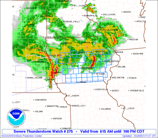
URGENT - IMMEDIATE BROADCAST REQUESTED
Severe Thunderstorm Watch Number 275
NWS Storm Prediction Center Norman OK
545 PM CDT Fri Jun 5 2026

The NWS Storm Prediction Center has issued a

* Severe Thunderstorm Watch for portions of
  Southwest Iowa
  North-Central and Northeast Kansas
  Northwest Missouri
  Southern and Eastern Nebraska

* Effective this Friday afternoon from 545 PM until Midnight CDT.

* Primary threats include...
  Scattered damaging winds and isolated significant gusts to 75
    mph possible
  Scattered large hail and isolated very large hail events to 2
    inches in diameter possible
  A tornado or two possible

SUMMARY...Thunderstorms should continue to develop this evening
along/near the Kansas/Nebraska border. The strongest thunderstorms
should pose a threat for large to very large hail (up to 2 inches in
diameter) and severe/damaging winds (up to 65-75 mph). A tornado or
two is also possible along/near a stationary front.

The severe thunderstorm watch area is approximately along and 55
statute miles north and south of a line from 30 miles southwest of
Hastings NE to 30 miles east of Shenandoah IA. For a complete
depiction of the watch see the associated watch outline update
(WOUS64 KWNS WOU5).

PRECAUTIONARY/PREPAREDNESS ACTIONS...

REMEMBER...A Severe Thunderstorm Watch means conditions are
favorable for severe thunderstorms in and close to the watch area.
Persons in these areas should be on the lookout for threatening
weather conditions and listen for later statements and possible
warnings. Severe thunderstorms can and occasionally do produce
tornadoes.

&&

OTHER WATCH INFORMATION...CONTINUE...WW 274...

AVIATION...A few severe thunderstorms with hail surface and aloft to
2 inches. Extreme turbulence and surface wind gusts to 65 knots. A
few cumulonimbi with maximum tops to 500. Mean storm motion vector
27020.

...Gleason
Read morehttps://www.spc.noaa.gov/products/watch/ww0275.html
|
|


CMS The Best Conveyancing solicitors conveyancing quotes throughout the UK
For any webhosting enquiries please email webmaster@aus-city.com
|
|
Forums60
Topics779,054
Posts813,849
Members2,960
| |
Most Online22,463
May 9th, 2026
|
|
|


 - Click image for larger picture.")


