|
1 members (Alisa),
746
guests, and
25
robots. |
|
Key:
Admin,
Global Mod,
Mod
|
|
S |
M |
T |
W |
T |
F |
S |
|
|
1
|
2
|
3
|
4
|
5
|
6
|
|
7
|
8
|
9
|
10
|
11
|
12
|
13
|
|
14
|
15
|
16
|
17
|
18
|
19
|
20
|
|
21
|
22
|
23
|
24
|
25
|
26
|
27
|
|
28
|
29
|
30
|
|
|
|
|
|
There are no members with birthdays on this day. |
|
|
|
|
|
|
|
|
by Webmaster - Thu 11 Jun 2026 03:33:AM
|
by Webmaster - Thu 11 Jun 2026 03:33:AM
|
by Webmaster - Thu 11 Jun 2026 03:33:AM
|
|
|
|
|
|
|

Volcano earthquake report for Thursday, 11 Jun 2026
• Moderate mag. 4.6 earthquake - South Pacific Ocean, Bay of Plenty, 354 km n...
• Moderate magnitude 4.9 earthquake 92 km southwest of Bima, Indonesia
• Moderate mag. 4.4 earthquake - Indian Ocean, 84 km south of Dompu, Indonesi...
• Strong mag. 5.5 earthquake - Philippine Sea, 144 km north of Sangihe Besar ...
• World Earthquake Report for Wednesday, 10 June 2026
|
|
|
Joined: Feb 2001
Posts: 678,976
Launch Director
|
OP

Launch Director
Joined: Feb 2001
Posts: 678,976 |
Moderate magnitude 4.9 earthquake 92 km southwest of Bima, Indonesia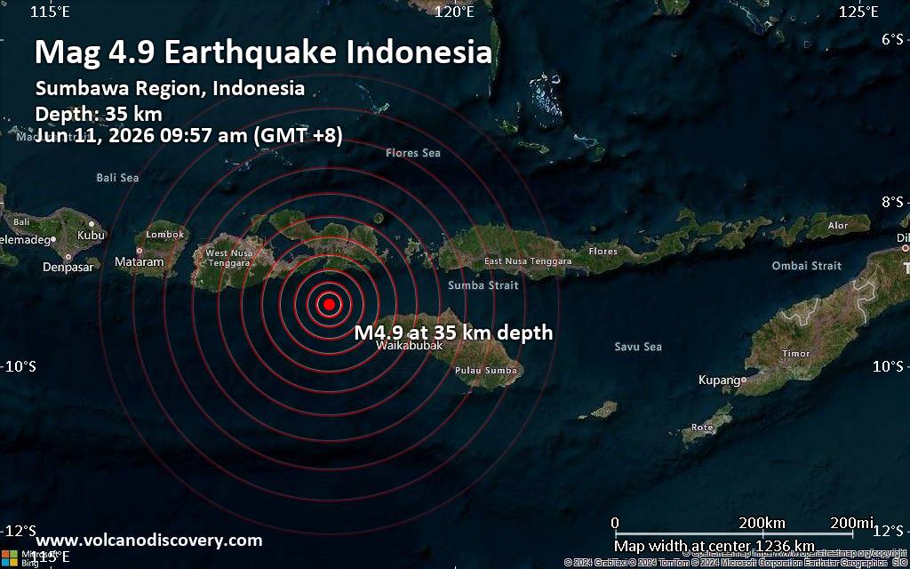 An earthquake of magnitude 4.9 occurred only 12 minutes ago 92 km southwest of Bima, Indonesia, Indonesia's Meteorology, Climatology, and Geophysical Agency reported.
The quake hit at a moderately shallow depth of 35. km beneath the epicenter near Bima, Bima City, West Nusa Tenggara, Indonesia, in the morning on Thursday, June 11th, 2026, at 9:57 am local time. The exact magnitude, epicenter, and depth of the quake might be revised within the next few hours or minutes as seismologists review data and refine their calculations, or as other agencies issue their report.
A second report was later issued by the citizen-seismograph network of RaspberryShake, which listed it as a magnitude 4.9 earthquake as well.
Based on the preliminary seismic data, the quake should not have caused any significant damage, but was probably felt by many people as light vibration in the area of the epicenter.
Weak shaking might have been felt in Dompu (pop. 55,000) located 78 km from the epicenter, Tambolaka (pop. 35,800) 90 km away, Bima (pop. 161,400) 92 km away, and Sape (pop. 5,000) 96 km away.
VolcanoDiscovery will automatically update magnitude and depth if these change and follow up if other significant news about the quake become available. If you’re in the area, please send us your experience through our reporting mechanism, either online or via our mobile app. This will help us provide more first-hand updates to anyone around the globe who wants to know more about this quake.
Earthquake data: Date & time: Jun 11, 2026 09:57 am (GMT +8) local time (11 Jun 2026 01:57 GMT)Magnitude: 4.9 Depth: 35.00 km Epicenter latitude / longitude: 9.24°S / 118.44°E  ( West Nusa Tenggara, Indonesia) Primary data source: BMKGhttps://www.volcanodiscovery.com/earthquake/news/305154/Moderate-magnitude-49-earthquake-92-km-southwest-of-Bima-Indonesia.html
|
|


CMS The Best Conveyancing solicitors conveyancing quotes throughout the UK
For any webhosting enquiries please email webmaster@aus-city.com
|
|
Forums60
Topics780,343
Posts815,101
Members2,960
| |
Most Online22,463
May 9th, 2026
|
|
|


 - Click image for larger picture.")


