|
|
|
0 members (),
1,791
guests, and
25
robots. |
|
Key:
Admin,
Global Mod,
Mod
|
|
S |
M |
T |
W |
T |
F |
S |
|
|
|
|
1
|
2
|
3
|
4
|
|
5
|
6
|
7
|
8
|
9
|
10
|
11
|
|
12
|
13
|
14
|
15
|
16
|
17
|
18
|
|
19
|
20
|
21
|
22
|
23
|
24
|
25
|
|
26
|
27
|
28
|
29
|
30
|
|
|
|
There are no members with birthdays on this day. |
|
|
|
|
SPC MD 376
by Webmaster - Fri 10 Apr 2026 09:52:PM
|
SPC MD 374
by Webmaster - Fri 10 Apr 2026 09:52:PM
|
SPC MD 375
by Webmaster - Fri 10 Apr 2026 09:52:PM
|
|
|
|
|
|
|
|
|
|
|
|
|
Joined: Feb 2001
Posts: 381,904
Launch Director
|
OP

Launch Director
Joined: Feb 2001
Posts: 381,904 |
Volcano earthquake report for Friday, 10 Apr 2026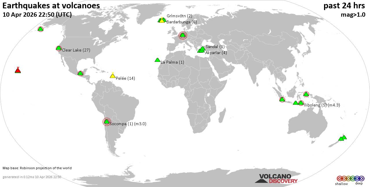 World map showing volcanoes with shallow (less than 50 km) earthquakes within 20 km radius during the past 24 hours on 10 Apr 2026 Number in brackets indicate nr of quakes. Quakes detected near: Akyarlar (3 quakes between mag 1.8-2.2), Bardarbunga (6 quakes between mag 0.1-1.0), Bibinoi (1 quake mag 2.4), Clear Lake (28 quakes between mag 0.2-2.2), El Chichón (5 quakes between mag 1.8-2.3), Grímsvötn (2 quakes between mag 0.3-1.8)
Hrómundartindur (8 quakes between mag 0.0-1.5), Hulubelu (4 quakes between mag 2.1-2.2), Iliboleng (4 quakes between mag 2.1-4.3), Katla (2 quakes between mag 0.8-1.6), Kilauea (19 quakes between mag 1.0-2.6), Kolumbo (1 quake mag 2.4), La Palma (1 quake mag 1.5), Laacher See (1 quake mag 3.0), Loihi (1 quake mag 2.1), Martin (1 quake mag 1.9), Okataina (Tarawera) (1 quake mag 1.6), Ruapehu (1 quake mag 1.1), Sandal (1 quake mag 1.2), Socompa (1 quake mag 3.0), Stepovak Bay 4 (1 quake mag 2.2), Taranaki (1 quake mag 1.2), Tindfjallajökull (1 quake mag 1.1) (updated 20h50)
Note: Earthquakes within 20 km from and at depths less than 50 km under active volcanoes are reported. The list is not complete because many volcanoes are not monitored and/or seismic data in high resolution is not available publicly.
Volcanoes with recent earthquakes above magnitude 2 or more than 10 quakes are listed below:
Akyarlar volcano (Turkey): 3 earthquakes up to magnitude 2.23 earthquakes occurred near (under) the volcano during 11 minutes, the last being recorded quake 7 hours ago. Hypocenter depths ranged between 13.90 and 8.00 km. Earthquake details: 2.2 quake Aegean Sea, 17 km east of Nisi Kos Island, Dodecanese, South Aegean, Greece, Apr 10, 2026 04:15 pm (GMT +3) (17 km S) 1.8 quake Aegean Sea, 11 km east of Nisi Kos Island, Dodecanese, South Aegean, Greece, Apr 10, 2026 04:27 pm (GMT +3) (19 km SSW) 1.8 quake Aegean Sea, 17 km east of Nisi Kos Island, Dodecanese, South Aegean, Greece, Apr 10, 2026 04:16 pm (GMT +3) (16 km S) All earthquakes at AkyarlarBibinoi volcano (Halmahera): magnitude 2.4 earthquakeA magnitude 2.4 earthquake occurred at the volcano 7 hours ago. The quake, which might be volcanic in origin, was located at a depth of 10.00 km depth at 11 km distance NNE from the volcano. Earthquake details: 2.4 quake Maluku Sea, 32 km east of Labuha, Indonesia, Apr 10, 2026 10:48 pm (GMT +9) (11 km NNE) All earthquakes at BibinoiClear Lake volcano (California): 28 earthquakes up to magnitude 2.2Possible earthquake swarm: 28 earthquakes occurred near (under) the volcano during 21 hours, the last being recorded quake 2 hours ago. Hypocenter depths ranged between 5.17 and 0.83 km. Earthquake details: (only 5 largest) 2.2 quake Sonoma County, 14 mi southwest of Clearlake, Lake County, California, United States, Apr 10, 2026 10:30 am (GMT -7) (17 km S) 1.9 quake Sonoma County, 14 mi southwest of Clearlake, Lake County, California, United States, Apr 10, 2026 10:29 am (GMT -7) (17 km S) 1.7 quake Sonoma County, 13 mi southwest of Clearlake, Lake County, California, United States, Apr 9, 2026 04:28 pm (GMT -7) (16 km S) 1.3 quake 27 mi north of Santa Rosa, Sonoma County, California, United States, Apr 10, 2026 12:51 am (GMT -7) (16 km S) 1.2 quake 28 mi north of Santa Rosa, Sonoma County, California, United States, Apr 10, 2026 01:38 am (GMT -7) (16 km SSW) All earthquakes at Clear LakeEl Chichón volcano (Southern Mexico): 5 earthquakes up to magnitude 2.35 earthquakes occurred near (under) the volcano during 9 hours, the last being recorded quake 14 hours ago. Hypocenter depths ranged between 3.00 and 3.00 km. Earthquake details: 2.3 quake Estado de Chiapas, 37 km southwest of Teapa, Estado de Tabasco, Mexico, Apr 9, 2026 04:02 pm (GMT -6) (1 km SE) 2.1 quake Estado de Chiapas, 35 km southwest of Teapa, Estado de Tabasco, Mexico, Apr 10, 2026 12:49 am (GMT -6) (2 km E) 2.1 quake Estado de Chiapas, 37 km southwest of Teapa, Estado de Tabasco, Mexico, Apr 9, 2026 04:03 pm (GMT -6) (1 km NW) 2.0 quake Estado de Chiapas, 36 km southwest of Teapa, Estado de Tabasco, Mexico, Apr 9, 2026 07:49 pm (GMT -6) (1 km NNE) 1.8 quake 20 km southwest of Pichucalco, Estado de Chiapas, Mexico, Apr 9, 2026 04:01 pm (GMT -6) (0 km NNW) All earthquakes at El ChichónHulubelu volcano (Sumatra): 4 earthquakes up to magnitude 2.24 earthquakes occurred near (under) the volcano during 37 minutes, the last being recorded quake 6 hours ago. Hypocenter depths ranged between 8.00 and 4.00 km. Earthquake details: 2.2 quake Kabupaten Tanggamus, 70 km west of Bandar Lampung, Indonesia, Apr 10, 2026 09:27 pm (GMT +7) (12 km SSE) 2.1 quake Kabupaten Tanggamus, 68 km west of Bandar Lampung, Indonesia, Apr 10, 2026 09:27 pm (GMT +7) (12 km SE) 2.1 quake Kabupaten Tanggamus, 68 km west of Bandar Lampung, Indonesia, Apr 10, 2026 10:04 pm (GMT +7) (12 km SE) 2.1 quake Kabupaten Tanggamus, 68 km west of Bandar Lampung, Indonesia, Apr 10, 2026 09:28 pm (GMT +7) (9 km E) All earthquakes at HulubeluIliboleng volcano (Lesser Sunda Islands): 4 earthquakes up to magnitude 4.34 earthquakes occurred near (under) the volcano during 5 hours, the last being recorded quake 15 hours ago. Hypocenter depths ranged between 7.00 and 3.00 km. Earthquake details: 4.3 quake Kabupaten Flores Timur, 31 km west of Lewoleba, Indonesia, Apr 10, 2026 01:39 pm (Makassar time) (16 km SW) 2.8 quake 31 km west of Lewoleba, Kabupaten Lembata, East Nusa Tenggara, Indonesia, Apr 10, 2026 01:41 pm (GMT +8) (16 km SW) 2.2 quake Kabupaten Flores Timur, 32 km west of Lewoleba, Indonesia, Apr 10, 2026 02:04 pm (GMT +8) (17 km SW) 2.1 quake Savu Sea, 14 km southeast of Pulau Adonara Island, East Nusa Tenggara, Indonesia, Apr 10, 2026 09:22 am (GMT +8) (10 km SSW) All earthquakes at IlibolengKilauea volcano (Hawai'i (Big Island)): 19 earthquakes up to magnitude 2.6Possible earthquake swarm: 19 earthquakes occurred near (under) the volcano during 16 hours, the last being recorded quake 3 hours ago. Hypocenter depths ranged between 31.24 and 0.04 km. Earthquake details: (only 5 largest) 2.6 quake 34 mi southwest of Hilo, Hawaii County, Hawaii, United States, Apr 9, 2026 04:25 pm (GMT -10) (13 km SSW) 2.0 quake 26 mi southwest of Hilo, Hawaii County, Hawaii, United States, Apr 9, 2026 04:37 pm (GMT -10) (2 km SE) 1.9 quake 4.5 mi southwest of Volcano, Hawaii County, Hawaii, United States, Apr 9, 2026 05:19 pm (GMT -10) (2 km SSE) 1.9 quake 26 mi southwest of Hilo, Hawaii County, Hawaii, United States, Apr 9, 2026 05:03 pm (GMT -10) (1 km SE) 1.9 quake 26 mi southwest of Hilo, Hawaii County, Hawaii, United States, Apr 9, 2026 07:37 pm (GMT -10) (2 km ESE) All earthquakes at KilaueaKolumbo volcano (Greece): magnitude 2.4 earthquakeA magnitude 2.4 earthquake occurred at the volcano 17 hours ago. The quake, which might be volcanic in origin, was located at a depth of 15.00 km depth at 12 km distance ENE from the volcano. Earthquake details: 2.4 quake Aegean Sea, 21 km northeast of Santorini Island, Greece, Apr 10, 2026 07:01 am (GMT +3) (12 km ENE) All earthquakes at KolumboLaacher See volcano (Germany): magnitude 3.0 earthquakeA magnitude 3.0 earthquake occurred at the volcano 10 hours ago. The quake, which might be volcanic in origin, was located at a depth of 10.00 km depth at 18 km distance SE from the volcano. Earthquake details: Reported seismic-like event (likely no quake): 8.8 km southwest of Koblenz, Germany, Apr 10, 2026 01:13 pm (GMT +2) (18 km SE) All earthquakes at Laacher SeeLoihi volcano (Hawai'i (Big Island)): magnitude 2.1 earthquakeA magnitude 2.1 earthquake occurred at the volcano 6 hours ago. The quake, which might be volcanic in origin, was located at a depth of 12.42 km depth at 14 km distance SE from the volcano. Earthquake details: 2.1 quake North Pacific Ocean, 63 mi south of Hilo, Hawaii County, Hawaii, United States, Apr 10, 2026 05:02 am (GMT -10) (14 km SE) All earthquakes at LoihiSocompa volcano (Northern Chile, Bolivia and Argentina): magnitude 3.0 earthquakeA magnitude 3.0 earthquake occurred at the volcano 4 hours ago. The quake, which might be volcanic in origin, was located at a depth of 10.00 km depth at 11 km distance WSW from the volcano. Earthquake details: Unconfirmed earthquake or seismic-like event: 192 km southeast of Baquedano, Provincia de Antofagasta, Region de Antofagasta, Chile, Apr 10, 2026 02:11 pm (GMT -3) (11 km WSW) All earthquakes at SocompaStepovak Bay 4 volcano (Alaska Peninsula): magnitude 2.2 earthquakeA magnitude 2.2 earthquake occurred at the volcano 4 hours ago. The quake, which might be volcanic in origin, was located at a depth of 6.60 km depth at 7 km distance E from the volcano. Earthquake details: 2.2 quake Lake and Peninsula Borough, 50 mi northeast of Sand Point, Aleutians East Borough, Alaska, United States, Apr 10, 2026 08:48 am (GMT -8) (7 km E) All earthquakes at Stepovak Bay 4https://www.volcanodiscovery.com/earthquakes-volcanoes/news/299640/Volcano-earthquake-report-for-Friday-10-Apr-2026.html
|
|


CMS The Best Conveyancing solicitors conveyancing quotes throughout the UK
For any webhosting enquiries please email webmaster@aus-city.com
|
|
Forums60
Topics768,629
Posts803,394
Members2,958
| |
Most Online17,963
Jan 15th, 2026
|
|
|
|
|
Copyright 1996 - 2026 by David Cottle. Designed by David Bate Jr. All Rights Reserved.
By using this forum, the user agrees not to transfer any data or technical information received under the agreement, to any other entity without the express approval of the AUS-CITY Forum Admins and/or authors of individual posts (Forum Admins and DoD/USSPACECOM for the analysis of satellite tracking data).
Two-line elements (TLE) and all other satellite data presented and distributed via this forum and e-mail lists of AUS-CITY are distributed with permission from DoD/USSTRATCOM.

Reprise Hosting

|

|


 - Click image for larger picture.")


