|
|
|
0 members (),
937
guests, and
24
robots. |
|
Key:
Admin,
Global Mod,
Mod
|
|
S |
M |
T |
W |
T |
F |
S |
|
|
|
1
|
2
|
3
|
4
|
5
|
|
6
|
7
|
8
|
9
|
10
|
11
|
12
|
|
13
|
14
|
15
|
16
|
17
|
18
|
19
|
|
20
|
21
|
22
|
23
|
24
|
25
|
26
|
|
27
|
28
|
29
|
30
|
|
|
|
Volcano earthquake report for Wednesday, 16 September 2026
• Strong mag. 5.1 earthquake - New Britain Region, Papua New Guinea, on Wedne...
• World Earthquake Report for Wednesday, 16 September 2026
• Strong mag. 5.0 earthquake - Departamento del Choco, 86 km west of La Union...
• Strong mag. 5.1 earthquake - Hawke's Bay, New Zealand, on Thursday, Sep 17,...
• M 1.6 - 17 km SW of Petersville, Alaska
|
 SPC MD 2302
Webmaster
Yesterday at 09:15 PM
SPC MD 2302
Webmaster
Yesterday at 09:15 PM
SPC MD 2302MD 2302 CONCERNING SEVERE POTENTIAL...WATCH UNLIKELY FOR EAST-CENTRAL INDIANA INTO CENTRAL OHIO 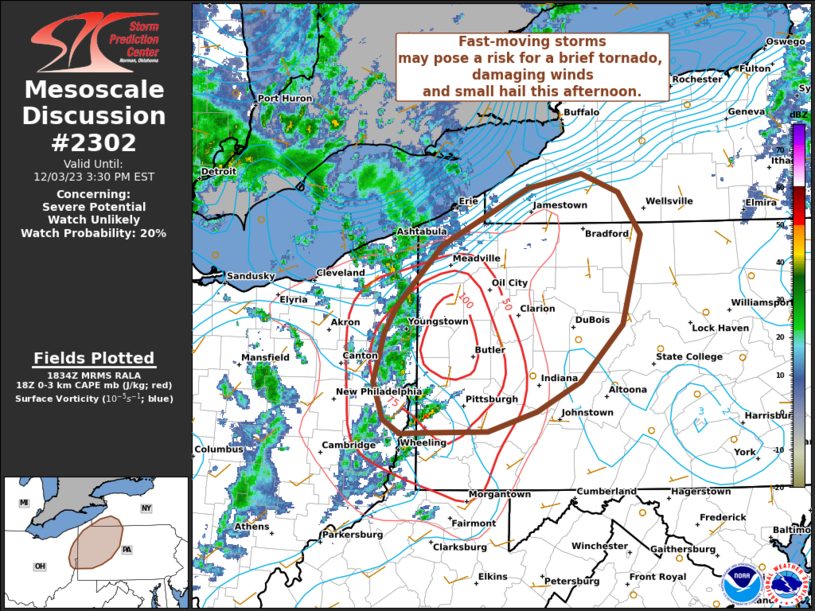
Mesoscale Discussion 2302
NWS Storm Prediction Center Norman OK
0246 PM CDT Wed Sep 16 2026

Areas affected...east-central Indiana into central Ohio

Concerning...Severe potential...Watch unlikely

Valid 161946Z - 162145Z

Probability of Watch Issuance...5 percent

SUMMARY...Isolated gusty winds of 45-60 mph will be possible with
stronger thunderstorms developing through early evening. Overall
risk is expected to remain limited, and a severe thunderstorm watch
is not expected.

DISCUSSION...Isolated thunderstorms are developing near the IN/OH
state border this afternoon. This activity is developing ahead of a
stalled front and on the southern periphery of stronger effective
shear located north of this boundary. Stronger heating across
east-central IN into central OH has allowed temperatures to warm
into the 80s to near 90 F amid mid 70s F dewpoints, resulting in
moderate instability. Effective shear magnitudes around 20-30 kt may
allow for some storm organization. However, weak midlevel lapse
rates will limit longevity of any stronger/better organized
updrafts. Nevertheless, steepened low-level lapse rates and high PW
values could support sporadic strong outflow wind gusts. Overall,
the risk is expected to remain limited and mostly sub-severe wind
gusts are anticipated, precluding watch issuance.

..Leitman/Hart.. 09/16/2026

...Please see www.spc.noaa.gov for graphic product...

ATTN...WFO...PBZ...RLX...CLE...ILN...IWX...IND...

LAT...LON   40178559 40798440 40878292 40458191 40008182 39698200
            39448292 39368434 39548533 39888566 40178559

MOST PROBABLE PEAK WIND GUST...UP TO 60 MPH
Read morehttps://www.spc.noaa.gov/products/md/md2302.html
0
30
Read More
|
SPC MD 2303
Webmaster
Yesterday at 09:15 PM
SPC MD 2303MD 2303 CONCERNING SEVERE POTENTIAL...WATCH UNLIKELY FOR PORTIONS OF NORTHEASTERN UTAH 
Mesoscale Discussion 2303
NWS Storm Prediction Center Norman OK
0353 PM CDT Wed Sep 16 2026

Areas affected...portions of northeastern Utah

Concerning...Severe potential...Watch unlikely

Valid 162053Z - 162300Z

Probability of Watch Issuance...20 percent

SUMMARY...Isolated to widely scattered thunderstorms will bring a
chance for occasional large hail and damaging wind gusts. Watch
issuance is unlikely.

DISCUSSION...Regional radar imagery depicts a developing supercell
across portions of central/northeastern Utah. While available
buoyancy remains relatively modest (generally 500-1000 J/kg MLCAPE),
strong upper-level flow is contributing to effective shear of 40-50
kts, which will continue to support a supercellular storm mode as
convection evolves eastward through this evening. The primary risk
with this activity will be large hail owing to elongated, relatively
straight hodographs; however, mid-level lapse rates remain somewhat
modest (around 7 C/km), which should temper the overall magnitude of
the large hail threat. Isolated damaging/severe wind gusts are also
possible, especially with any stronger downdrafts and/or evolving
clusters. The overall magnitude and spatial extent of the severe
risk are expected to remain too limited to warrant watch issuance,
however.

..Chalmers/Thompson.. 09/16/2026

...Please see www.spc.noaa.gov for graphic product...

ATTN...WFO...GJT...SLC...

LAT...LON   39121136 39221161 39451177 39661184 40031177 40361117
            40461010 40370944 40150916 39830909 39540918 39340951
            39191018 39121136

MOST PROBABLE PEAK WIND GUST...UP TO 60 MPH
MOST PROBABLE PEAK HAIL SIZE...1.00-1.75 IN
Read morehttps://www.spc.noaa.gov/products/md/md2303.html
0
29
Read More
|
Volcano earthquake report for Wednesday, 16 September 2026
Webmaster
Yesterday at 08:50 PM
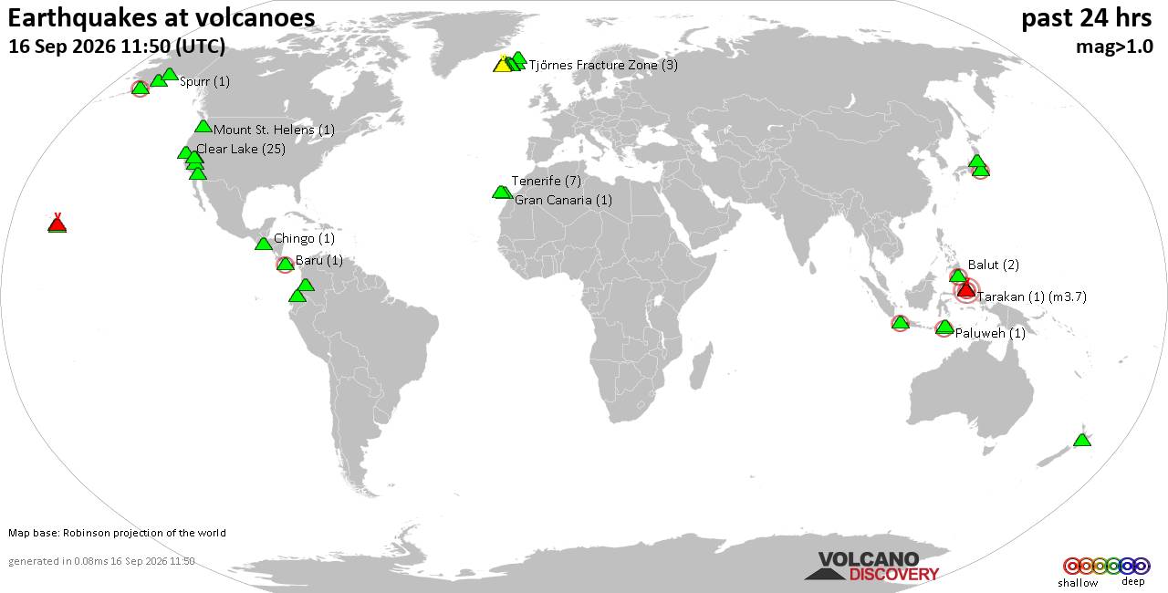
Volcano earthquake report for Wednesday, 16 September 2026World map showing volcanoes with shallow (less than 50 km) earthquakes within 20 km radius during the past 24 hours on 16 Sep 2026 Number in brackets indicate nr of quakes. Quakes detected near: Augustine (1 quake mag 1.7), Balut (4 quakes between mag 1.7-3.3), Bardarbunga (3 quakes between mag 0.0-1.9), Baru (1 quake mag 2.1), Brennisteinsfjöll (5 quakes between mag 0.1-1.0), Clear Lake (19 quakes between mag 0.3-1.6)
Coso (4 quakes between mag 1.0-2.1), Ebulobo (1 quake mag 2.5), Eldey (8 quakes between mag 0.7-2.5), Hekla (3 quakes between mag 0.6-1.2), Ibu (1 quake mag 3.3), Katmai (1 quake mag 1.2), Kilauea (2 quakes between mag 1.1-1.7), Ljósufjöll (3 quakes between mag 0.8-1.4), Loihi (1 quake mag 1.8), Mammoth Mountain (1 quake mag 1.2), Maroa (1 quake mag 1.6), Michoacán-Guanajuato (1 quake mag 4.0), Nevado del Huila (2 quakes between mag 1.4-2.3), Ngauruhoe (1 quake mag 1.6), Nii-jima (1 quake mag 2.5), Okataina (Tarawera) (1 quake mag 1.6), Omanago (1 quake mag 2.6), Paluweh (2 quakes between mag 2.1-3.4), Papandayan (10 quakes between mag 2.0-3.2), Pocdol Mountains (1 quake mag 1.7), Prestahnukur (28 quakes between mag 0.3-2.0), Pululahua (1 quake mag 1.9), Spurr (1 quake mag 1.3), Svartsengi (9 quakes between mag 0.2-1.8), Tarakan (1 quake mag 3.7), Tecuamburro (1 quake mag 1.6), Tenerife (5 quakes between mag 0.4-1.2), Tjörnes Fracture Zone (2 quakes between mag 1.0-1.2), Tobaru (1 quake mag 3.7), Torfajökull (4 quakes between mag 0.1-1.8), Tsurumi (1 quake mag 2.6) (updated 20h50)\n\nNote: Earthquakes within 20 km from and at depths less than 50 km under active volcanoes are reported. The list is not complete because many volcanoes are not monitored and/or seismic data in high resolution is not available publicly.\n
Volcanoes with recent earthquakes above magnitude 2 or more than 10 quakes are listed below:
Balut volcano (Mindanao): 4 earthquakes up to magnitude 3.34 earthquakes occurred near (under) the volcano during 7 hours, the last being recorded quake 1 hour 57 minutes ago. Hypocenter depths ranged between 33.00 and 15.00 km. Earthquake details: 3.3 quake Celebes Sea, 23 km west of Sarangani Island, Philippines, Sep 16, 2026 10:37 pm (GMT +8) (13 km WNW) 2.5 quake 12 km west of Sarangani, Davao Occidental, Davao, Philippines, Sep 17, 2026 02:53 am (GMT +8) (3 km NW) 1.8 quake Celebes Sea, 25 km southwest of Sarangani Island, Philippines, Sep 16, 2026 08:00 pm (GMT +8) (13 km SW) 1.7 quake Celebes Sea, 23 km southwest of Sarangani Island, Philippines, Sep 16, 2026 11:58 pm (GMT +8) (12 km SSW) All earthquakes at BalutBalut is an 840 m island stratovolcano south of Mindanao whose last known eruption occurred between about 2 million and 11,700 years ago. Hot springs and thermally altered ground occur on its western and southwestern flanks. Baru volcano (Panama): magnitude 2.1 earthquakeA magnitude 2.1 earthquake occurred at the volcano 14 hours ago. The quake, which might be volcanic in origin, was located at a depth of 8.00 km depth at 18 km distance S from the volcano. Earthquake details: 2.1 quake 29 km northwest of David, Provincia de Chiriqui, Panama, Sep 16, 2026 01:58 am (Costa_Rica time) (18 km S) All earthquakes at BaruClear Lake volcano (California): 19 earthquakes up to magnitude 1.6Possible earthquake swarm: 19 earthquakes occurred near (under) the volcano during 21 hours, the last being recorded quake 29 minutes ago. Hypocenter depths ranged between 18.00 and 0.55 km. Earthquake details: (only 5 largest) 1.6 quake Sonoma County, 14 mi southwest of Clearlake, Lake County, California, United States, Sep 16, 2026 04:36 am (GMT -7) (16 km SSW) 1.1 quake Lake County, 28 mi north of Santa Rosa, Sonoma County, California, United States, Sep 16, 2026 08:20 pm (Universal Time) (15 km S) 1.1 quake 28 mi north of Santa Rosa, Sonoma County, California, United States, Sep 16, 2026 06:45 pm (Universal Time) (15 km SSW) 1.1 quake 25 mi north of Santa Rosa, Sonoma County, California, United States, Sep 16, 2026 03:25 pm (Universal Time) (19 km S) 1.1 quake 26 mi north of Santa Rosa, Sonoma County, California, United States, Sep 16, 2026 12:06 pm (Universal Time) (17 km S) All earthquakes at Clear LakeCoso volcano (California): 4 earthquakes up to magnitude 2.14 earthquakes occurred near (under) the volcano during 15 hours, the last being recorded quake 5 hours ago. Hypocenter depths ranged between 5.30 and 1.00 km. Earthquake details: 2.1 quake Inyo County, 28 mi north of Ridgecrest, Kern County, California, United States, Sep 15, 2026 08:58 pm (GMT -7) (2 km SSE) 1.5 quake Inyo County, 34 mi north of Ridgecrest, Kern County, California, United States, Sep 16, 2026 08:55 am (GMT -7) (9 km NW) 1.4 quake Inyo County, 29 mi north of Ridgecrest, Kern County, California, United States, Sep 15, 2026 09:54 pm (GMT -7) (4 km E) 1.0 quake Inyo County, 34 mi north of Ridgecrest, Kern County, California, United States, Sep 15, 2026 06:06 pm (GMT -7) (9 km NW) All earthquakes at CosoCoso is a 400 km² volcanic field of rhyolitic domes, basaltic cones and lava flows east of the Sierra Nevada Range. Its youngest dated eruption occurred about 39,000 ± 33,000 years ago, while active fumaroles and thermal springs mark an important geothermal area. Ebulobo volcano (Flores): magnitude 2.5 earthquakeA magnitude 2.5 earthquake occurred at the volcano 16 hours ago. The quake, which might be volcanic in origin, was located at a depth of 10.00 km depth at 10 km distance NNE from the volcano. Earthquake details: 2.5 quake Kabupaten Nagekeo, 50 km west of Ende, Indonesia, Sep 16, 2026 12:55 pm (GMT +8) (10 km NNE) All earthquakes at EbuloboEbulobo is a 2,096 m stratovolcano in central Flores, Indonesia. Seven confirmed eruptive periods are recorded between 1830 and 1969, while an ash plume in 2017 was classified as an uncertain eruption. Eldey volcano (Iceland): 8 earthquakes up to magnitude 2.58 earthquakes occurred near (under) the volcano during 5 hours, the last being recorded quake 18 hours ago. Hypocenter depths ranged between 45.80 and 0.00 km. Earthquake details: (only 5 largest) 2.5 quake Iceland: 2.3 km ESE of Geirfugladrangur Sep 15, 2026 10:20 pm (Reykjavik time) (14 km WSW) 2.2 quake Iceland: 7.0 km SE of Geirfugladrangur Sep 16, 2026 03:02 am (Reykjavik time) (15 km SW) 1.6 quake 3.3 km WNW of Geirfugladrangur Sep 15, 2026 10:32 pm (Universal Time) (18 km WSW) 1.5 quake 9.5 km NNW of Geirfugladrangur Sep 15, 2026 10:44 pm (Universal Time) (19 km W) 1.2 quake Iceland: 7.5 km SE of Eldey Sep 15, 2026 10:32 pm (Reykjavik time) (9 km ESE) All earthquakes at EldeyEldey is a mostly submarine volcanic system south of Iceland, with only an island and several rocky skerries above water. Five eruptions are confirmed from 1211 to 1926, and an additional event in 1884 is uncertain. Ibu volcano (Halmahera): magnitude 3.3 earthquakeA magnitude 3.3 earthquake occurred at the volcano 18 hours ago. The quake, which might be volcanic in origin, was located at a depth of 10.00 km depth at 13 km distance ENE from the volcano. Earthquake details: 3.3 quake 37 km southwest of Tobelo, Kabupaten Halmahera Utara, North Maluku, Indonesia, Sep 16, 2026 12:08 pm (GMT +9) (13 km ENE) All earthquakes at IbuIbu is an active stratovolcano on Halmahera, Indonesia, with nested summit craters and a growing lava dome. An eruption that began in April 2008 was still producing daily eruptive events in August 2026. Michoacán-Guanajuato volcano (Western & Central Mexico): magnitude 4.0 earthquakeA magnitude 4.0 earthquake occurred at the volcano 20 hours ago. The quake, which might be volcanic in origin, was located at a depth of 6.00 km depth at 19 km distance E from the volcano. Earthquake details: 4.0 quake 4.5 km east of Patzcuaro, Estado de Michoacan de Ocampo, Mexico, Sep 15, 2026 06:41 pm (Mexico City time) (19 km E) All earthquakes at Michoacán-GuanajuatoThis extensive volcanic field in west-central Mexico has more than 1,400 vents. Its best-known cinder cones are Jorullo, active in 1759-74, and Parícutin, which arose in a former cornfield and erupted from 1943 to 1952. Nevado del Huila volcano (Colombia): 2 earthquakes up to magnitude 2.32 earthquakes occurred near (under) the volcano during 5 hours, the last being recorded quake 13 hours ago. Hypocenter depths ranged between 10.00 and 7.00 km. Earthquake details: 2.3 quake Departamento del Huila, 35 km north of Belalcazar, Colombia, Sep 16, 2026 02:56 am (GMT -5) (3 km NNE) 1.4 quake Departamento de Tolima, 38 km southeast of Miranda, Colombia, Sep 15, 2026 09:53 pm (GMT -5) (10 km NNE) All earthquakes at Nevado del HuilaNevado del Huila is the highest peak in the Colombian Andes. After centuries without a recorded eruption, it reawakened in 2007; a major eruption and lahars killed ten people in 2008. Nii-jima volcano (Izu Islands): magnitude 2.5 earthquakeA magnitude 2.5 earthquake occurred at the volcano 18 hours ago. The quake, which might be volcanic in origin, was located at a depth of 45.70 km depth at 14 km distance S from the volcano. Earthquake details: 2.5 quake Philippine Sea, 15 km northeast of Kozu Shima Island, Tokyo, Japan, Sep 16, 2026 12:13 pm (GMT +9) (14 km S) All earthquakes at Nii-jimaNii-jima is a rhyolitic volcanic island in Japan’s Izu Volcanic Arc. Its last known eruption, at Mukai-yama in 886 CE, combined explosive activity with lava-dome formation. Omanago volcano (Honshu): magnitude 2.6 earthquakeA magnitude 2.6 earthquake occurred at the volcano 12 hours ago. The quake, which might be volcanic in origin, was located at a depth of 4.00 km depth at 4 km distance WNW from the volcano. Earthquake details: 2.6 quake 18 km northwest of Nikko, Tochigi, Japan, Sep 16, 2026 05:21 pm (GMT +9) (4 km WNW) All earthquakes at OmanagoOmanago is a closely spaced group of lava domes in Japan’s Nikko National Park. Its only known eruptive period formed a dome at Mitsudake around 3050 BCE, though the date is uncertain. Paluweh volcano (Lesser Sunda Islands): 2 earthquakes up to magnitude 3.42 earthquakes occurred near (under) the volcano during 17 hours, the last being recorded quake 6 hours ago. Hypocenter depths ranged between 48.00 and 11.00 km. Earthquake details: 3.4 quake Flores Sea, 57 km north of Ende, Kabupaten Ende, East Nusa Tenggara, Indonesia, Sep 16, 2026 10:50 pm (GMT +8) (18 km W) 2.1 quake Flores Sea, 48 km north of Ende, Kabupaten Ende, East Nusa Tenggara, Indonesia, Sep 16, 2026 05:27 am (GMT +8) (18 km SW) All earthquakes at PaluwehPaluweh is an island-forming stratovolcano north of Flores, Indonesia. Its major eruptions include a destructive, tsunami-producing event in 1928 and deadly pyroclastic flows in 2013. Papandayan volcano (West Java): 10 earthquakes up to magnitude 3.210 earthquakes occurred near (under) the volcano during 17 hours, the last being recorded quake 4 hours ago. Hypocenter depths ranged between 10.00 and 10.00 km. Earthquake details: (only 5 largest) 3.2 quake 18 km southeast of Banjar, Kabupaten Bandung, Jawa Barat, Indonesia, Sep 16, 2026 11:12 am (GMT +7) (17 km WNW) 3.1 quake 22 km south of Banjaran, Kabupaten Bandung, Jawa Barat, Indonesia, Sep 16, 2026 08:11 am (GMT +7) (14 km NW) 2.9 quake 20 km east of Banjar, Kabupaten Bandung, Jawa Barat, Indonesia, Sep 16, 2026 09:35 am (GMT +7) (16 km WNW) 2.8 quake 20 km east of Banjar, Kabupaten Bandung, Jawa Barat, Indonesia, Sep 16, 2026 11:14 am (GMT +7) (16 km WNW) 2.7 quake 20 km east of Banjar, Kabupaten Bandung, Jawa Barat, Indonesia, Sep 16, 2026 05:14 pm (GMT +7) (16 km WNW) All earthquakes at PapandayanPapandayan is an active Indonesian stratovolcano whose 1772 eruption and flank collapse destroyed 40 villages and killed almost 3,000 people. Its crater complex remains marked by strong fumarolic activity. Prestahnukur volcano (Iceland): 28 earthquakes up to magnitude 2.0Possible earthquake swarm: 28 earthquakes occurred near (under) the volcano during 23 hours, the last being recorded quake 39 minutes ago. Hypocenter depths ranged between 16.30 and 0.00 km. Earthquake details: (only 5 largest) 2.0 quake 11.5 km S of Eiríksjökull Sep 16, 2026 06:56 pm (Universal Time) (13 km NE) 1.9 quake Iceland: 13.1 km S of Eiríksjökull Sep 16, 2026 08:11 pm (Reykjavik time) (9 km NE) 1.9 quake Iceland: 11.6 km S of Eiríksjökull Sep 16, 2026 05:34 pm (Reykjavik time) (13 km NE) 1.5 quake 11.6 km SSE of Eiríksjökull Sep 16, 2026 02:21 pm (Universal Time) (13 km ENE) 1.5 quake 11.9 km S of Eiríksjökull Sep 16, 2026 08:16 am (Universal Time) (12 km NE) All earthquakes at PrestahnukurPrestahnúkur is a roughly 90-km-long volcanic system beside the Langjökull icecap in Iceland. Its three known eruptions occurred during the past 10,000 years, the last at approximately 3350 BCE. Tarakan volcano (Halmahera): magnitude 3.7 earthquakeA magnitude 3.7 earthquake occurred at the volcano 24 hours ago. The quake, which might be volcanic in origin, was located at a depth of 10.00 km depth at 6 km distance SSW from the volcano. Earthquake details: 3.7 quake 23 km west of Tobelo, Kabupaten Halmahera Utara, North Maluku, Indonesia, Sep 16, 2026 05:56 am (GMT +9) (6 km SSW) All earthquakes at TarakanTarakan comprises two basaltic cinder cones on northern Halmahera, Indonesia. Both have prominent summit craters, but their last eruption is undated and no historical activity is known. Tobaru volcano (Halmahera): magnitude 3.7 earthquakeA magnitude 3.7 earthquake occurred at the volcano 19 hours ago. The quake, which might be volcanic in origin, was located at a depth of 10.00 km depth at 10 km distance SSE from the volcano. Earthquake details: 3.7 quake Kabupaten Halmahera Barat, 39 km southwest of Tobelo, Indonesia, Sep 16, 2026 11:03 am (GMT +9) (10 km SSE) All earthquakes at TobaruTobaru is a little-known stratovolcano in northern Halmahera, Indonesia, also associated with the names Loloda and Lolodai. No eruption during approximately the past 12,000 years has been identified, and its last eruption is undated. Tsurumi volcano (Kyushu): magnitude 2.6 earthquakeA magnitude 2.6 earthquake occurred at the volcano 7 hours ago. The quake, which might be volcanic in origin, was located at a depth of 10.10 km depth at 11 km distance WSW from the volcano. Earthquake details: 2.6 quake 17 km west of Beppu, Oita Prefecture, Japan, Sep 16, 2026 10:43 pm (GMT +9) (11 km WSW) All earthquakes at TsurumiTsurumi is part of the Yufu-Tsurumi lava-dome complex above Beppu on Kyushu. Its three known eruptive periods culminated in explosive summit activity in 867 CE. https://www.volcanodiscovery.com/earthquakes-volcanoes/news/355764/Volcano-earthquake-report-2026-09-16.html
0
227
Read More
|
|
Forums60
Topics829,271
Posts864,065
Members2,960
| |
Most Online102,106
Jul 10th, 2026
|
|
|
|
|

|