|
|
|
0 members (),
629
guests, and
27
robots. |
|
Key:
Admin,
Global Mod,
Mod
|
|
S |
M |
T |
W |
T |
F |
S |
|
|
1
|
2
|
3
|
4
|
5
|
6
|
|
7
|
8
|
9
|
10
|
11
|
12
|
13
|
|
14
|
15
|
16
|
17
|
18
|
19
|
20
|
|
21
|
22
|
23
|
24
|
25
|
26
|
27
|
|
28
|
29
|
30
|
31
|
|
|
|
|
There are no members with birthdays on this day. |
 SPC Day 1 Fire Weather Outlook
Webmaster
1 hour ago
SPC Day 1 Fire Weather Outlook
Webmaster
1 hour ago
SPC Day 1 Fire Weather OutlookSPC Day 1 Fire Weather Outlook 
Day 1 Fire Weather Outlook
NWS Storm Prediction Center Norman OK
1058 AM CST Wed Dec 17 2025

Valid 171700Z - 181200Z

The previous forecast remains on track with only minor expansions
made across southeast CO/southwest KS to reflect latest high-res
guidance. 16 UTC surface observations show winds beginning to
increase along the northern CO Front Range, but the strongest winds
are expected later this afternoon (mainly between 20-00 UTC) as the
mid-level jet begins to impinge on the northern Rockies. It remains
unclear exactly how severe RH reductions will be in the lee of the
immediate front range where peak winds are expected. While some
guidance shows RH minimums near 20%, morning solutions don't appear
to be accurately capturing recent satellite trends with more
widespread cloud cover noted in GOES imagery than depicted in recent
HRRR/RRFS runs. This continues to limit confidence in the potential
for widespread critical fire weather conditions, though localized
critical conditions may emerge if sufficient clearing can occur.
Regardless, the strong winds coupled with slowly increasing ERC
values (near the 70th percentile) should still support a wind-driven
fire weather risk. See the previous discussion below for additional
details.

..Moore.. 12/17/2025

.PREV DISCUSSION... /ISSUED 1150 PM CST Tue Dec 16 2025/

...Synopsis...
A potent upper trough will move through the Northwest and reach the
Plains by Thursday morning. At the surface, a cyclone will deepen in
the northern Plains with a trough extending into the
central/southern Plains.

...Central/southern High Plains...
Strong mid-level winds will be nearly perpendicular to the Rockies.
This, coupled with a strong cross-Divide pressure gradient, will
foster strong sustained winds and stronger gusts in the immediate
lee of the terrain. Sustained 20-30 mph winds will be probable in
the terrain-favored areas. A period of wind gusts to 60-70 mph are
expected in the lower foothills. Farther east and south, 15-20 mph
will become more common. RH will be above elevated criteria in many
places, but 15-25% will be possible from Wyoming into Colorado.
Farther south, RH will more likely be around 15-20%. With fuels
having continued to dry, the strong surface winds will still lead to
elevated to locally critical fire weather.

...Piedmont...
Dry and modestly breezy conditions appear possible within the region
during the afternoon. RH could fall as low as 20-25%, but there is
variability within guidance. Winds will generally be light at around
10 mph. Locally elevated conditions are possible, but the
duration/spatial extent is too limited and uncertain for highlights.

...Please see www.spc.noaa.gov/fire for graphic product...
Read morehttps://www.spc.noaa.gov/products/fire_wx/fwdy1.html
0
6
Read More
|
SPC Dec 17, 2025 1630 UTC Day 1 Convective Outlook
Webmaster
1 hour ago
SPC Dec 17, 2025 1630 UTC Day 1 Convective OutlookSPC 1630Z Day 1 Outlook 
Day 1 Convective Outlook
NWS Storm Prediction Center Norman OK
1022 AM CST Wed Dec 17 2025

Valid 171630Z - 181200Z

...THERE IS A MARGINAL RISK OF SEVERE THUNDERSTORMS ACROSS PARTS OF
SOUTHERN IDAHO AND NORTHERN UTAH...

...SUMMARY...
While strong to locally severe winds may occur with low-topped
convection through early afternoon across parts of southern Idaho
and northern Utah, the overall threat for organized severe
thunderstorms appears low.

...Interior Northwest and Northern Great Basin/Rockies...
A powerful mid-level shortwave trough and associated sub-980 mb
surface low will move quickly eastward today across the interior
Northwest/northern Rockies and adjacent western Canada. A strong
surface cold front will likewise translate east-southeastward over
the northern Intermountain/Great Basin region late this morning into
the afternoon. Widespread cloud cover remains prevalent ahead of the
front across southern ID into northern UT and vicinity, with cool
surface temperatures and very limited low-level moisture also
present. MUCAPE is expected to remain only barely sufficient to
support convection. But, given the enhanced flow at low levels noted
on recent VWPs from KCBX/KSFX, it is not entirely out of the
question that convectively augmented gusts may exceed the already
strong background gradient winds on a localized basis. The Marginal
Risk has therefore been maintained for parts of southern ID/northern
UT and vicinity, even though the overall threat for organized severe
thunderstorms will remain low.

..Gleason/Weinman.. 12/17/2025
Read morehttps://www.spc.noaa.gov/products/outlook/day1otlk_1630.html
0
2
Read More
|
SPC Dec 17, 2025 1300 UTC Day 1 Convective Outlook
Webmaster
5 hours ago
SPC Dec 17, 2025 1300 UTC Day 1 Convective OutlookSPC 1300Z Day 1 Outlook
Day 1 Convective Outlook
NWS Storm Prediction Center Norman OK
0655 AM CST Wed Dec 17 2025

Valid 171300Z - 181200Z

...THERE IS A MARGINAL RISK OF SEVERE THUNDERSTORMS ACROSS PARTS OF
THE NORTHWEST AND NORTHERN INTERMOUNTAIN REGION...

...SUMMARY...
Sporadic severe wind gusts may accompany low-topped convection
across parts of the Northwest and northern Intermountain region this
morning into midday.

...Northwest/Northern Intermountain region...
A progressive/vigorous shortwave trough will continue to modestly
amplify and otherwise race east-southeastward from the
Washington/British Columbia border vicinity this morning to the
northern Plains tonight. Intense deep-tropospheric flow (highlighted
by 55-85 kt at 700 mb) will accompany this wave, yielding widespread
high winds across much of the Northwest to the northern Great
Plains.

Low-topped convection, occasionally capable of lightning and
semi-organized line segments, will continue in association with the
east/southeastward-advancing cold front, with convection potentially
expanding by late morning towards the Snake River Plain/Yellowstone
vicinity and potentially other parts of the northeast Great Basin by
afternoon. Surface-based instability will be very limited, but some
convectively enhanced wind gusts may occur.

..Guyer/Lyons.. 12/17/2025
Read morehttps://www.spc.noaa.gov/products/outlook/day1otlk_1300.html
0
2
Read More
|
World Earthquake Report for Tuesday, 16 December 2025
Webmaster
Yesterday at 07:20 PM
World Earthquake Report for Tuesday, 16 December 2025 Worldwide earthquakes above magnitude 3 during the past 24 hours on 16 Dec 2025 Magnitude 5+: 8 earthquakes Magnitude 4+: 37 earthquakes Magnitude 3+: 172 earthquakes Magnitude 2+: 423 earthquakes No quakes of magnitude 6 or higher 10 largest earthquakes in the world (past 24 hours)Tuesday, Dec 16, 2025, at 09:06 am (GMT +10) - Tuesday, Dec 16, 2025, at 06:33 am (GMT +11) - Tuesday, Dec 16, 2025, at 08:18 pm (GMT +11) - Tuesday, Dec 16, 2025, at 01:41 am (GMT +2) - Tuesday, Dec 16, 2025, at 03:38 pm (GMT +10) - Tuesday, Dec 16, 2025, at 12:44 pm (GMT -1) - Tuesday, Dec 16, 2025, at 12:45 pm (GMT -1) - Monday, Dec 15, 2025, at 11:48 pm (GMT +4) - Tuesday, Dec 16, 2025, at 09:08 pm (Sakhalin time) - Tuesday, Dec 16, 2025, at 11:39 pm (GMT +12) - Earthquakes reported feltTuesday, Dec 16, 2025, at 01:01 am (GMT +1) - Monday, Dec 15, 2025, at 10:55 pm (Managua time) - Tuesday, Dec 16, 2025, at 01:41 am (GMT +2) - Tuesday, Dec 16, 2025, at 12:50 am (Karachi time) - Tuesday, Dec 16, 2025, at 09:06 am (GMT +10) - Tuesday, Dec 16, 2025, at 04:42 am (Santiago time) - Tuesday, Dec 16, 2025, at 12:14 am (Puerto Rico time) - Tuesday, Dec 16, 2025, at 06:33 am (GMT +11) - Tuesday, Dec 16, 2025, at 04:11 pm (Istanbul time) - Tuesday, Dec 16, 2025, at 05:53 am (GMT -8) - Monday, Dec 15, 2025, at 06:12 pm (GMT -8) - Tuesday, Dec 16, 2025, at 03:10 am (Santiago time) - Tuesday, Dec 16, 2025, at 07:06 am (GMT -8) - Monday, Dec 15, 2025, at 05:29 pm (GMT -8) - Tuesday, Dec 16, 2025, at 11:45 am (GMT +9) - Tuesday, Dec 16, 2025, at 05:39 am (GMT +7) - Tuesday, Dec 16, 2025, at 08:30 am (GMT +2) - Monday, Dec 15, 2025, at 10:21 pm (GMT +2) - Tuesday, Dec 16, 2025, at 06:06 am (GMT +9) - Earthquake stats  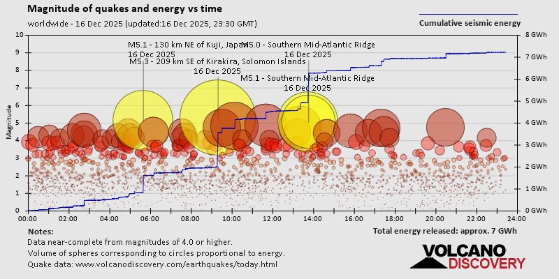 https://www.volcanodiscovery.com/earthquake/news/289533/World-Earthquake-Report-for-Tuesday-16-December-2025.html https://www.volcanodiscovery.com/earthquake/news/289533/World-Earthquake-Report-for-Tuesday-16-December-2025.html
0
27
Read More
|
World Earthquake Report for December 2025
Webmaster
Yesterday at 07:00 PM
World Earthquake Report for December 2025 Worldwide earthquakes above magnitude 5.5 during December 2025 Magnitude 9+: none Magnitude 8+: none Magnitude 7+: 2 earthquakes Magnitude 6+: 2 earthquakes Magnitude 5+: 89 earthquakes Magnitude 4+: 754 earthquakes Magnitude 3+: 3378 earthquakes Magnitude 2+: 6768 earthquakes No quakes of magnitude 8 or higher List of 10 largest earthquakes in the world during December 2025:Monday, Dec 8, 2025, at 11:15 pm (GMT +9) - Saturday, Dec 6, 2025, at 11:41 am (Yakutat time) - Thursday, Dec 4, 2025, at 01:44 pm (Urumqi time) - Tuesday, Dec 9, 2025, at 04:56 am (GMT +10) - Sunday, Dec 7, 2025, at 05:56 pm (Whitehorse time) - Monday, Dec 8, 2025, at 03:34 am (GMT +11) - Wednesday, Dec 3, 2025, at 11:35 am (GMT +12) - Sunday, Dec 7, 2025, at 11:16 pm (Efate time) - Friday, Dec 5, 2025, at 12:33 pm (GMT -7) - Monday, Dec 8, 2025, at 04:41 pm (GMT -2) - Earthquake stats: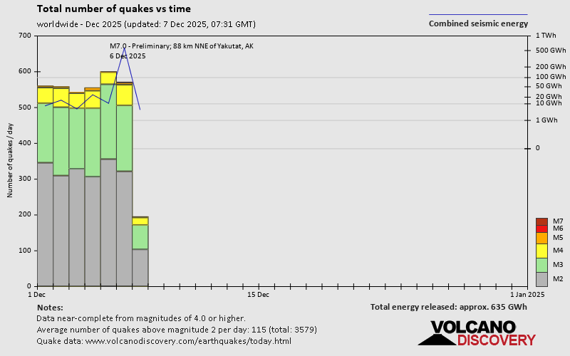 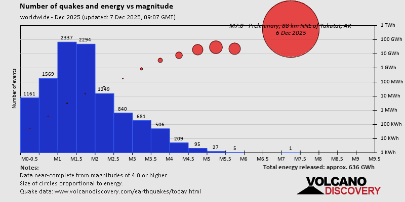 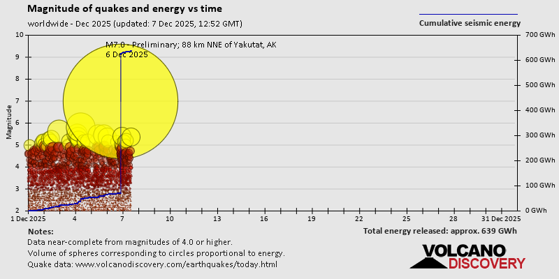 https://www.volcanodiscovery.com/view_news/288462/World-Earthquake-Report-for-December-2025.html https://www.volcanodiscovery.com/view_news/288462/World-Earthquake-Report-for-December-2025.html
0
25
Read More
|
Volcano earthquake report for Tuesday, 16 Dec 2025
Webmaster
Yesterday at 06:50 PM
Volcano earthquake report for Tuesday, 16 Dec 2025 World map showing volcanoes with shallow (less than 50 km) earthquakes within 20 km radius during the past 24 hours on 16 Dec 2025 Number in brackets indicate nr of quakes. Quakes detected near: Akuseki-jima (3 quakes between mag 1.1-1.9), Apaneca Range (1 quake mag 2.1), Apo (5 quakes between mag 1.7-2.7), Aso (38 quakes between mag 0.2-3.6), Brennisteinsfjöll (8 quakes between mag 0.1-1.6), Clear Lake (27 quakes between mag 0.2-1.3)
El Chichón (6 quakes between mag 2.1-2.7), Etna (1 quake mag 1.3), Fourpeaked (5 quakes between mag 0.3-2.1), Geureudong (1 quake mag 2.8), Gran Canaria (2 quakes between mag 1.3-1.6), Katla (2 quakes between mag 0.6-1.1), Kilauea (4 quakes between mag 1.1-2.1), Kirishima (4 quakes between mag 0.1-1.8), Kolumbo (3 quakes between mag 1.8-2.7), Kozushima (1 quake mag 2.0), Krísuvík (5 quakes between mag 0.1-1.2), Kukak (1 quake mag 2.4), La Palma (1 quake mag 1.0), Ljósufjöll (4 quakes between mag 0.4-1.0), Loki-Fögrufjöll volcano (9 quakes between mag 0.3-1.6), Long Valley (2 quakes between mag 0.8-1.0), Masaya (1 quake mag 3.0), Mayotte Island (1 quake mag 1.0), Methana (3 quakes between mag 1.2-1.3), Nakano-shima (2 quakes between mag 1.4-1.4), Paluweh (1 quake mag 2.5), Prestahnukur (1 quake mag 1.2), Salton Buttes (2 quakes between mag 1.4-1.8), Sandal (2 quakes between mag 0.9-1.2), Svartsengi (2 quakes between mag 0.8-1.0), Torfajökull (6 quakes between mag 1.2-2.1) (updated 18h50)
Note: Earthquakes within 20 km from and at depths less than 50 km under active volcanoes are reported. The list is not complete because many volcanoes are not monitored and/or seismic data in high resolution is not available publicly.
Volcanoes with recent earthquakes above magnitude 2 or more than 10 quakes are listed below:
Apaneca Range volcano (El Salvador): magnitude 2.1 earthquakeA magnitude 2.1 earthquake occurred at the volcano 8 hours ago. The quake, which might be volcanic in origin, was located at a depth of 5.00 km depth at 7 km distance E from the volcano. Earthquake details: 2.1 quake 18 km north of Sonsonate, Departamento de Sonsonate, El Salvador, Dec 16, 2025 04:46 am (GMT -6) (7 km E) All earthquakes at Apaneca RangeApo volcano (Mindanao): 5 earthquakes up to magnitude 2.75 earthquakes occurred near (under) the volcano during 10 hours, the last being recorded quake 5 hours ago. Hypocenter depths ranged between 33.00 and 7.00 km. Earthquake details: 2.7 quake 32 km west of Davao City, Province of Davao del Sur, Davao, Philippines, Dec 16, 2025 11:26 am (GMT +8) (15 km NNE) 2.2 quake Province of Davao del Sur, 25 km northeast of Kidapawan, Philippines, Dec 16, 2025 07:57 pm (GMT +8) (14 km N) 2.2 quake 28 km west of Davao City, Province of Davao del Sur, Davao, Philippines, Dec 16, 2025 11:24 am (GMT +8) (18 km NE) 2.0 quake 30 km west of Davao City, Province of Davao del Sur, Davao, Philippines, Dec 16, 2025 09:47 pm (GMT +8) (15 km NNE) 1.7 quake 17 km east of Kidapawan, Cotabato, Soccsksargen, Philippines, Dec 16, 2025 11:19 am (GMT +8) (4 km SW) All earthquakes at ApoApo volcano (2938 m) on Mindanao forms the highest peak of the Philippines. Its volcanic history is not well known, but although there are no historic eruptions it is considered to be active. The volcano has an extensive hydrothermal field with ongoing geothermal exploration. Small shallow earthquakes related to this activity are common. Aso volcano (Kyushu): 38 earthquakes up to magnitude 3.6Possible earthquake swarm: 38 earthquakes occurred near (under) the volcano during 19 hours, the last being recorded quake 5 hours ago. Hypocenter depths ranged between 10.90 and 3.20 km. Earthquake details: (only 5 largest) 3.6 quake 42 km northeast of Koto, Kumamoto, Japan, Dec 16, 2025 11:13 pm (GMT +9) (12 km N) 2.1 quake 6.9 km northeast of Aso, Kumamoto, Japan, Dec 16, 2025 07:04 am (GMT +9) (12 km N) 1.9 quake 6.7 km northeast of Aso, Kumamoto, Japan, Dec 16, 2025 06:38 am (GMT +9) (12 km N) 1.9 quake 3.5 km northwest of Aso, Kumamoto, Japan, Dec 16, 2025 08:34 am (GMT +9) (10 km NNW) 1.7 quake 7.1 km northeast of Aso, Kumamoto, Japan, Dec 16, 2025 06:32 am (GMT +9) (12 km N) All earthquakes at AsoClear Lake volcano (California): 27 earthquakes up to magnitude 1.3Possible earthquake swarm: 27 earthquakes occurred near (under) the volcano during 21 hours, the last being recorded quake 1 hour 25 minutes ago. Hypocenter depths ranged between 3.45 and 0.28 km. Earthquake details: (only 5 largest) 1.3 quake 25 mi north of Santa Rosa, Sonoma County, California, United States, Dec 16, 2025 02:51 am (GMT -8) (19 km S) 1.3 quake 27 mi north of Santa Rosa, Sonoma County, California, United States, Dec 16, 2025 05:32 am (GMT -8) (17 km S) 1.1 quake 28 mi north of Santa Rosa, Sonoma County, California, United States, Dec 16, 2025 04:50 am (GMT -8) (16 km SSW) 1.1 quake Lake County, 28 mi north of Santa Rosa, Sonoma County, California, United States, Dec 16, 2025 01:10 am (GMT -8) (15 km SSW) 1.0 quake 26 mi north of Santa Rosa, Sonoma County, California, United States, Dec 15, 2025 12:16 pm (GMT -8) (17 km S) All earthquakes at Clear LakeEl Chichón volcano (Southern Mexico): 6 earthquakes up to magnitude 2.76 earthquakes occurred near (under) the volcano during 7 hours, the last being recorded quake 15 hours ago. Hypocenter depths ranged between 3.20 and 3.00 km. Earthquake details: (only 5 largest) 2.7 quake Estado de Chiapas, 38 km southwest of Teapa, Estado de Tabasco, Mexico, Dec 15, 2025 02:49 pm (GMT -6) (2 km SSE) 2.5 quake Estado de Chiapas, 37 km southwest of Teapa, Estado de Tabasco, Mexico, Dec 15, 2025 10:00 pm (GMT -6) (2 km SSE) 2.3 quake Estado de Chiapas, 36 km southwest of Teapa, Estado de Tabasco, Mexico, Dec 15, 2025 04:04 pm (GMT -6) (1 km ESE) 2.2 quake Estado de Chiapas, 36 km southwest of Teapa, Estado de Tabasco, Mexico, Dec 15, 2025 07:31 pm (GMT -6) (2 km ESE) 2.2 quake Estado de Chiapas, 36 km southwest of Teapa, Estado de Tabasco, Mexico, Dec 15, 2025 04:02 pm (GMT -6) (1 km NNE) All earthquakes at El ChichónFourpeaked volcano (Alaska Peninsula): 5 earthquakes up to magnitude 2.15 earthquakes occurred near (under) the volcano during 4 hours, the last being recorded quake 19 hours ago. Hypocenter depths ranged between 16.30 and 3.96 km. Earthquake details: 2.1 quake 81 mi northwest of Kodiak, Kodiak Island Borough, Alaska, United States, Dec 15, 2025 10:19 am (GMT -9) (6 km SSW) 1.8 quake Kenai Peninsula Borough, 82 mi northwest of Kodiak, Kodiak Island Borough, Alaska, United States, Dec 15, 2025 02:20 pm (GMT -9) (5 km WSW) 0.7 quake Kenai Peninsula Borough, 84 mi northwest of Kodiak, Kodiak Island Borough, Alaska, United States, Dec 15, 2025 11:39 am (GMT -9) (9 km WSW) 0.7 quake Kenai Peninsula Borough, 84 mi northwest of Kodiak, Kodiak Island Borough, Alaska, United States, Dec 15, 2025 11:56 am (GMT -9) (8 km WSW) 0.3 quake Kenai Peninsula Borough, 83 mi northwest of Kodiak, Kodiak Island Borough, Alaska, United States, Dec 15, 2025 02:20 pm (GMT -9) (8 km WSW) All earthquakes at FourpeakedGeureudong volcano (Sumatra): magnitude 2.8 earthquakeA magnitude 2.8 earthquake occurred at the volcano 1 hour 35 minutes ago. The quake, which might be volcanic in origin, was located at a depth of 3.00 km depth at 3 km distance SSW from the volcano. Earthquake details: 2.8 quake Kabupaten Bener Meriah, 61 km southwest of Lhokseumawe, Indonesia, Dec 17, 2025 12:14 am (GMT +7) (3 km SSW) All earthquakes at GeureudongKilauea volcano (Hawai'i (Big Island)): 4 earthquakes up to magnitude 2.14 earthquakes occurred near (under) the volcano during 4 hours, the last being recorded quake 16 hours ago. Hypocenter depths ranged between 32.43 and 3.29 km. Earthquake details: 2.1 quake 36 mi southwest of Hilo, Hawaii County, Hawaii, United States, Dec 15, 2025 04:54 pm (GMT -10) (16 km SSW) 1.9 quake 27 mi south of Hilo, Hawaii County, Hawaii, United States, Dec 15, 2025 02:47 pm (GMT -10) (16 km ESE) 1.8 quake 27 mi south of Hilo, Hawaii County, Hawaii, United States, Dec 15, 2025 01:02 pm (GMT -10) (16 km ESE) 1.1 quake 27 mi south of Hilo, Hawaii County, Hawaii, United States, Dec 15, 2025 02:47 pm (GMT -10) (16 km ESE) All earthquakes at KilaueaKolumbo volcano (Greece): 3 earthquakes up to magnitude 2.73 earthquakes occurred near (under) the volcano during 2 hours, the last being recorded quake 17 hours ago. Hypocenter depths ranged between 16.00 and 10.64 km. Earthquake details: 2.7 quake Aegean Sea, 26 km northeast of Santorini Island, Greece, Dec 16, 2025 01:41 am (GMT +2) (14 km ENE) 2.6 quake Aegean Sea, 18 km north of Santorini Island, Greece, Dec 16, 2025 04:06 am (GMT +2) (6 km NW) 1.8 quake Aegean Sea, 90 km east of Adamantas, Nomos Kykladon, South Aegean, Greece, Dec 16, 2025 04:09 am (GMT +2) (11 km NNW) All earthquakes at KolumboKukak volcano (Alaska Peninsula): magnitude 2.4 earthquakeA magnitude 2.4 earthquake occurred at the volcano 14 hours ago. The quake, which might be volcanic in origin, was located at a depth of 5.00 km depth at 8 km distance ENE from the volcano. Earthquake details: 2.4 quake 82 mi northwest of Kodiak, Kodiak Island Borough, Alaska, United States, Dec 15, 2025 07:42 pm (GMT -9) (8 km ENE) All earthquakes at KukakMasaya volcano (Nicaragua): magnitude 3.0 earthquakeA magnitude 3.0 earthquake occurred at the volcano 13 hours ago. The quake, which might be volcanic in origin, was located at a depth of 10.00 km depth at 11 km distance NW from the volcano. Earthquake details: Reported seismic-like event (likely no quake): 8.3 km southeast of Managua, Departamento de Managua, Nicaragua, Dec 15, 2025 11:43 pm (GMT -6) (11 km NW) All earthquakes at MasayaPaluweh volcano (Lesser Sunda Islands): magnitude 2.5 earthquakeA magnitude 2.5 earthquake occurred at the volcano 22 hours ago. The quake, which might be volcanic in origin, was located at a depth of 1.00 km depth at 19 km distance E from the volcano. Earthquake details: 2.5 quake Kabupaten Ende, 50 km northwest of Maumere, Indonesia, Dec 16, 2025 05:00 am (GMT +8) (19 km E) All earthquakes at PaluwehTorfajökull volcano (Iceland): 6 earthquakes up to magnitude 2.16 earthquakes occurred near (under) the volcano during 4 hours, the last being recorded quake 17 hours ago. Hypocenter depths ranged between 3.50 and 0.10 km. Earthquake details: (only 5 largest) 2.1 quake 2.1 km W of Landmannalaugar Dec 15, 2025 10:10 pm (Universal Time) (7 km NNE) 1.9 quake 2.5 km W of Landmannalaugar Dec 15, 2025 10:07 pm (Universal Time) (7 km NNE) 1.6 quake 9.7 km WSW of Landmannalaugar Dec 16, 2025 12:37 am (Universal Time) (4 km NW) 1.3 quake 7.1 km WSW of Landmannalaugar Dec 16, 2025 02:08 am (Universal Time) (5 km NNW) 1.3 quake 2.3 km W of Landmannalaugar Dec 15, 2025 10:09 pm (Universal Time) (8 km NNE) All earthquakes at Torfajökullhttps://www.volcanodiscovery.com/earthquakes-volcanoes/news/289516/Volcano-earthquake-report-for-Tuesday-16-Dec-2025.html
0
28
Read More
|
Small earthquake of magnitude 3.0 just reported 72 km southwest of La Ciotat, France
Webmaster
Yesterday at 06:13 PM
Small earthquake of magnitude 3.0 just reported 72 km southwest of La Ciotat, France A magnitude 3.0 earthquake near La Ciotat, Bouches-du-Rhône, Provence-Alpes-Cote d'Azur, France, was reported only 9 minutes ago by France's Réseau National de Surveillance Sismique (RéNaSS), considered the main national agency that monitors seismic activity in this part of the world. The earthquake occurred at a very shallow depth of 5. km beneath the epicenter early evening on Tuesday, December 16th, 2025, at 6:03 pm local time. The exact magnitude, epicenter, and depth of the quake might be revised within the next few hours or minutes as seismologists review data and refine their calculations, or as other agencies issue their report.
A second report was later issued by the European-Mediterranean Seismological Centre (EMSC), which listed it as a magnitude 2.7 earthquake.
According to preliminary calculations, we do not expect that the quake was felt by many people and did not cause any damage. In La Ciotat (pop. 33,100, 72 km away), the quake was probably not felt.
Earthquake data: Date & time: Dec 16, 2025 06:03 pm (GMT +0) local time (16 Dec 2025 18:03 GMT)Magnitude: 3.0 Depth: 5.00 km Epicenter latitude / longitude: 42.61°N / 5.17°E  ( France) Primary data source: RENASShttps://www.volcanodiscovery.com/earthquake/news/289564/Small-earthquake-of-magnitude-30-just-reported-72-km-southwest-of-La-Ciotat-France.html
0
31
Read More
|
Seismic-like event, possible earthquake, reported few minutes ago near Fukushima, Fukushima, Japan
Webmaster
Yesterday at 03:18 PM
Seismic-like event, possible earthquake, reported few minutes ago near Fukushima, Fukushima, Japan Unconfirmed quake or seismic-like event reported: 26 km east of Fukushima, Fukushima, Japan, 4 minutes ago We are receiving unverified early reports of ground shaking possibly caused by seismic activity in or near Fukushima, Fukushima, Japan on 16 Dec 2025 (GMT) at approximately 15:14 GMT.
There are no details yet on the magnitude or depth of this possible quake. If confirmed, we can expect more accurate data to emerge in the next few minutes. The location, magnitude and time mentioned are indicative, based on our best-fit seismic model. They are temporary until our AllQuakes monitoring service receives more exact scientific data from a national or international seismological agency. Check back here shortly and stay safe.
Earthquake data: Date & time: Dec 17, 2025 12:14 am (GMT +9) local time (16 Dec 2025 15:14 GMT)Magnitude: unspecified Depth: unspecified Epicenter latitude / longitude: 37.72°N / 140.76°E  ( Fukushima, Japan) Primary data source: VolcanoDiscoveryhttps://www.volcanodiscovery.com/earthquake/news/289558/Seismic-like-event-possible-earthquake-reported-few-minutes-ago-near-Fukushima-Fukushima-Japan.html
0
40
Read More
|
Small magnitude 3.8 earthquake 26 miles southwest of Kalifornsky, Alaska, United States
Webmaster
Yesterday at 11:49 AM
Small magnitude 3.8 earthquake 26 miles southwest of Kalifornsky, Alaska, United States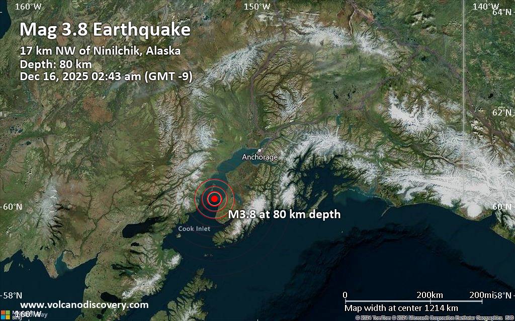 A magnitude 3.8 earthquake near Kalifornsky, Kenai Peninsula, Alaska, USA, was reported only 4 minutes ago by the United States Geological Survey, considered the key international and national agency that monitors seismic activity in the US. The earthquake occurred at an intermediate depth of 50 miles beneath the epicenter early morning on Tuesday, December 16th, 2025, at 2:43 am local time. The exact magnitude, epicenter, and depth of the quake might be revised within the next few hours or minutes as seismologists review data and refine their calculations, or as other agencies issue their report.
Our monitoring service identified a second report from The Incorporated Research Institutions for Seismology (IRIS) which listed the quake at magnitude 3.8 as well. A third agency, the European-Mediterranean Seismological Centre (EMSC), reported the same quake at magnitude 3.8.
According to preliminary calculations, we do not expect that the quake was felt by many people and did not cause any damage. In Ninilchik (pop. 880, 11 miles away), Cohoe (pop. 1,400, 24 miles away), Kalifornsky (pop. 7,900, 26 miles away), Anchor Point (pop. 1,900, 27 miles away), Kenai (pop. 7,700, 34 miles away), Soldotna (pop. 4,500, 35 miles away), Homer (pop. 5,500, 38 miles away), and Nikiski (pop. 4,500, 41 miles away), the quake was probably not felt.
Earthquake data: Date & time: Dec 16, 2025 02:43 am (GMT -9) local time (16 Dec 2025 11:43 GMT)Magnitude: 3.8 Depth: 79.80 km Epicenter latitude / longitude: 60.17°N / 151.87°W  (Kenai Peninsula, Alaska, United States) Primary data source: USGShttps://www.volcanodiscovery.com/earthquake/news/289552/Small-magnitude-38-earthquake-26-miles-southwest-of-Kalifornsky-Alaska-United-States.html
0
20
Read More
|
|
Forums60
Topics752,467
Posts787,156
Members2,958
| |
Most Online11,610
Dec 2nd, 2025
|
|
|
|
|
Copyright 1996 - 2024 by David Cottle. Designed by David Bate Jr. All Rights Reserved.
By using this forum, the user agrees not to transfer any data or technical information received under the agreement, to any other entity without the express approval of the AUS-CITY Forum Admins and/or authors of individual posts (Forum Admins and DoD/USSPACECOM for the analysis of satellite tracking data).
Two-line elements (TLE) and all other satellite data presented and distributed via this forum and e-mail lists of AUS-CITY are distributed with permission from DoD/USSTRATCOM.


Reprise Hosting

|

|


 - Click image for larger picture.")


