|
|
|
0 members (),
4,385
guests, and
27
robots. |
|
Key:
Admin,
Global Mod,
Mod
|
|
S |
M |
T |
W |
T |
F |
S |
|
|
|
|
|
1
|
2
|
3
|
|
4
|
5
|
6
|
7
|
8
|
9
|
10
|
|
11
|
12
|
13
|
14
|
15
|
16
|
17
|
|
18
|
19
|
20
|
21
|
22
|
23
|
24
|
|
25
|
26
|
27
|
28
|
29
|
30
|
31
|
|
There are no members with birthdays on this day. |
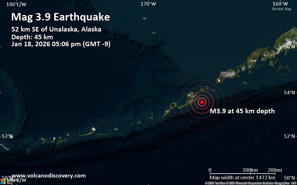
 Small magnitude 3.9 earthquake 32 miles southeast of Unalaska, Alaska, United States
Webmaster
3 hours ago
Small magnitude 3.9 earthquake 32 miles southeast of Unalaska, Alaska, United States
Webmaster
3 hours ago
Small magnitude 3.9 earthquake 32 miles southeast of Unalaska, Alaska, United StatesAn earthquake of magnitude 3.9 occurred in the afternoon on Sunday, January 18th, 2026, at 5:06 pm local time near Unalaska, Aleutians West, Alaska, USA, as reported by the United States Geological Survey.
According to preliminary data, the quake was located at a moderately shallow depth of 28 miles. The exact magnitude, epicenter, and depth of the quake might be revised within the next few hours or minutes as seismologists review data and refine their calculations, or as other agencies issue their report.
Our monitoring service identified a second report from the European-Mediterranean Seismological Centre (EMSC) which listed the quake at magnitude 3.9 as well.
Towns or cities near the epicenter where the quake might have been felt as very weak shaking include Unalaska (pop. 4,500) located 32 miles from the epicenter, Dutch Harbor (pop. 4,400) 33 miles away, and Akutan (pop. 1000) 40 miles away.
Earthquake data: Date & time: Jan 19, 2026 02:06 am (Universal Time) local time (19 Jan 2026 02:06 GMT)Magnitude: 3.9 Depth: 44.86 km Epicenter latitude / longitude: 53.56°N / 165.94°W  (Aleutians West, Alaska, United States) Primary data source: USGShttps://www.volcanodiscovery.com/earthquake/news/292297/Small-magnitude-39-earthquake-32-miles-southeast-of-Unalaska-Alaska-United-States.html
0
20
Read More
|
Small 2.9 quake hits near Fontana, San Bernardino County, California, USA
Webmaster
4 hours ago
Small 2.9 quake hits near Fontana, San Bernardino County, California, USA A magnitude 2.9 earthquake near Fontana, San Bernardino County, California, USA, was reported only 16 minutes ago by the United States Geological Survey, considered the key international and national agency that monitors seismic activity in the US. The earthquake occurred at a very shallow depth of 4.8 miles beneath the epicenter in the afternoon on Sunday, January 18th, 2026, at 5:41 pm local time. The exact magnitude, epicenter, and depth of the quake might be revised within the next few hours or minutes as seismologists review data and refine their calculations, or as other agencies issue their report.
Our monitoring service identified a second report from The Incorporated Research Institutions for Seismology (IRIS) which listed the quake at magnitude 2.9 as well. A third agency, the European-Mediterranean Seismological Centre (EMSC), reported the same quake at magnitude 2.9.
Towns or cities near the epicenter where the quake might have been felt as very weak shaking include Fontana (pop. 212,700) located 5 miles from the epicenter, Rialto (pop. 103,100) 5 miles away, San Bernardino (pop. 216,100) 8 miles away, Colton (pop. 54,600) 9 miles away, Rancho Cucamonga (pop. 175,200) 10 miles away, Upland (pop. 76,400) 13 miles away, Riverside (pop. 317,300) 14 miles away, and Ontario (pop. 171,200) 14 miles away. In Anaheim (pop. 350,700, 36 miles away), the quake was probably not felt.
Earthquake data: Date & time: Jan 18, 2026 05:41 pm (GMT -8) local time (19 Jan 2026 01:41 GMT)Magnitude: 2.9 Depth: 7.70 km Epicenter latitude / longitude: 34.16°N / 117.43°W ( San Bernardino County, California, United States) Primary data source: USGShttps://www.volcanodiscovery.com/earthquake/news/292293/Small-29-quake-hits-near-Fontana-San-Bernardino-County-California-USA.html
0
20
Read More
|
Volcano earthquake report for Monday, 19 Jan 2026
Webmaster
4 hours ago
Volcano earthquake report for Monday, 19 Jan 2026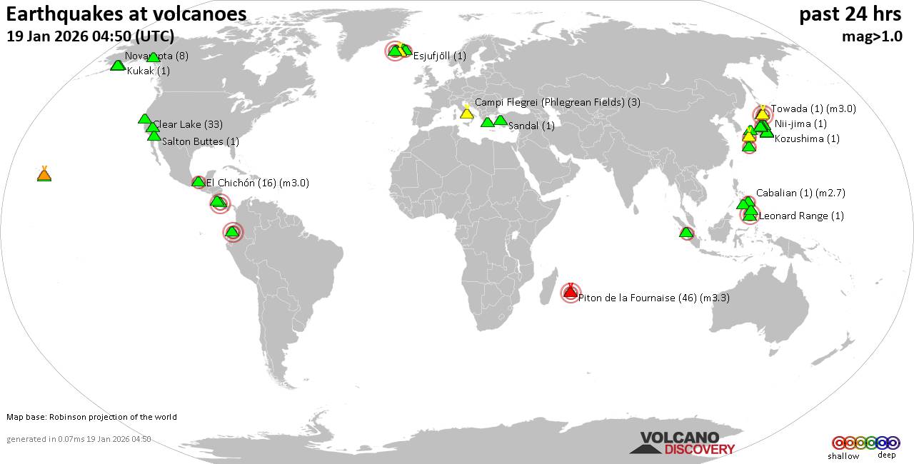 World map showing volcanoes with shallow (less than 50 km) earthquakes within 20 km radius during the past 24 hours on 19 Jan 2026 Number in brackets indicate nr of quakes. Quakes detected near: Abu (25 quakes between mag 0.1-1.2), Akuseki-jima (1 quake mag 2.1), Arenal (1 quake mag 1.9), Aso (6 quakes between mag 0.2-3.2), Balut (1 quake mag 3.0), Bardarbunga (2 quakes between mag 0.7-1.5)
Brennisteinsfjöll (1 quake mag 3.0), Cabalian (1 quake mag 2.7), Campi Flegrei (Phlegrean Fields) (3 quakes between mag 0.1-1.4), Churchill (1 quake mag 1.2), Clear Lake (30 quakes between mag 0.2-1.3), Coso (8 quakes between mag 0.7-1.5), Cuernos de Negros (1 quake mag 3.0), El Chichón (10 quakes between mag 2.2-2.9), Esjufjöll (1 quake mag 2.0), Guagua Pichincha (1 quake mag 3.0), Hiuchi (5 quakes between mag 0.1-1.4), Hrómundartindur (2 quakes between mag 0.8-1.1), Irazu (1 quake mag 3.0), Katla (1 quake mag 1.5), Katmai (2 quakes between mag 0.7-1.3), Kilauea (6 quakes between mag 1.7-1.9), Kukak (1 quake mag 1.1), Leonard Range (1 quake mag 1.8), Loihi (2 quakes between mag 1.7-2.2), Miravalles (1 quake mag 2.5), Myoko (39 quakes between mag 0.1-2.1), Nii-jima (1 quake mag 1.2), Norikura (7 quakes between mag 0.2-1.1), Novarupta (8 quakes between mag 0.6-1.2), Oshima (1 quake mag 1.0), Piton de la Fournaise (44 quakes between mag 0.0-3.3), Salton Buttes (1 quake mag 1.0), Sanbe (1 quake mag 3.0), Sandal (1 quake mag 1.3), Snowy Mountain (4 quakes between mag 0.9-2.3), Sousaki (1 quake mag 1.7), Tandikat (1 quake mag 2.1), Tenorio (1 quake mag 3.0), To-shima (1 quake mag 1.5), Torfajökull (2 quakes between mag 1.5-1.7), Towada (1 quake mag 3.0), Washiba-Kumonotaira (35 quakes between mag 0.1-1.9) (updated 01h50)
Note: Earthquakes within 20 km from and at depths less than 50 km under active volcanoes are reported. The list is not complete because many volcanoes are not monitored and/or seismic data in high resolution is not available publicly.
Volcanoes with recent earthquakes above magnitude 2 or more than 10 quakes are listed below:
Abu volcano (Honshu): 25 earthquakes up to magnitude 1.2Possible earthquake swarm: 25 earthquakes occurred near (under) the volcano during 20 hours, the last being recorded quake 1 hour 44 minutes ago. Hypocenter depths ranged between 33.20 and 28.70 km. Earthquake details: (only 5 largest) 1.2 quake 30 km north of Yamaguchi, Yamaguchi, Japan, Jan 18, 2026 12:54 pm (GMT +9) (7 km SSW) 0.9 quake 29 km north of Yamaguchi, Yamaguchi, Japan, Jan 18, 2026 03:50 pm (GMT +9) (8 km SSW) 0.8 quake 31 km north of Yamaguchi, Yamaguchi, Japan, Jan 19, 2026 07:41 am (GMT +9) (6 km S) 0.7 quake 30 km north of Yamaguchi, Yamaguchi, Japan, Jan 18, 2026 03:28 pm (GMT +9) (8 km S) 0.6 quake 29 km north of Yamaguchi, Yamaguchi, Japan, Jan 18, 2026 04:11 pm (GMT +9) (8 km S) All earthquakes at AbuAkuseki-jima volcano (Ryukyu Islands): magnitude 2.1 earthquakeA magnitude 2.1 earthquake occurred at the volcano 18 hours ago. The quake, which might be volcanic in origin, was located at a depth of 10.30 km depth at 14 km distance SSW from the volcano. Earthquake details: 2.1 quake East China Sea, Kagoshima-ken, 36 km southwest of Suwanose-jima Island, Japan, Jan 18, 2026 05:15 pm (GMT +9) (14 km SSW) All earthquakes at Akuseki-jimaAso volcano (Kyushu): 6 earthquakes up to magnitude 3.26 earthquakes occurred near (under) the volcano during 17 hours, the last being recorded quake 1 hour 2 minutes ago. Hypocenter depths ranged between 10.40 and 7.30 km. Earthquake details: (only 5 largest) 3.2 quake 32 km northeast of Kumamoto, Kumamoto, Japan, Jan 19, 2026 09:47 am (GMT +9) (11 km WNW) 2.9 quake 7.5 km west of Aso, Kumamoto, Japan, Jan 19, 2026 09:47 am (GMT +9) (11 km WNW) 0.7 quake 44 km northeast of Kumamoto, Kumamoto, Japan, Jan 19, 2026 04:20 am (GMT +9) (14 km N) 0.5 quake 45 km northeast of Kumamoto, Kumamoto, Japan, Jan 19, 2026 03:33 am (GMT +9) (12 km N) 0.4 quake 44 km northeast of Kumamoto, Kumamoto, Japan, Jan 19, 2026 12:07 am (GMT +9) (12 km N) All earthquakes at AsoBalut volcano (Mindanao): magnitude 3.0 earthquakeA magnitude 3.0 earthquake occurred at the volcano 17 hours ago. The quake, which might be volcanic in origin, was located at a depth of 10.00 km depth at 2 km distance N from the volcano. Earthquake details: Reported quake or seismic-like event: 30 km east of General Santos, Philippines, Jan 18, 2026 05:04 pm (GMT +8) (2 km N) All earthquakes at BalutBrennisteinsfjöll volcano (Reykjanes Peninsula, Iceland): magnitude 3.0 earthquakeA magnitude 3.0 earthquake occurred at the volcano 2 hours ago. The quake, which might be volcanic in origin, was located at a depth of 10.00 km depth at 19 km distance NNW from the volcano. Earthquake details: Reported seismic-like event (likely no quake): 5.3 km south of Reykjavik, Capital Region, Iceland, Jan 18, 2026 11:43 pm (GMT +0) (19 km NNW) All earthquakes at BrennisteinsfjöllCabalian volcano (Central Philippines): magnitude 2.7 earthquakeA magnitude 2.7 earthquake occurred at the volcano 5 hours ago. The quake, which might be volcanic in origin, was located at a depth of 1.00 km depth at 11 km distance WNW from the volcano. Earthquake details: 2.7 quake 40 km northeast of Maasin, Philippines, Jan 19, 2026 04:52 am (GMT +8) (11 km WNW) All earthquakes at CabalianClear Lake volcano (California): 30 earthquakes up to magnitude 1.3Possible earthquake swarm: 30 earthquakes occurred near (under) the volcano during 23 hours, the last being recorded quake 43 minutes ago. Hypocenter depths ranged between 14.82 and 0.70 km. Earthquake details: (only 5 largest) 1.3 quake 28 mi north of Santa Rosa, Sonoma County, California, United States, Jan 18, 2026 07:59 am (GMT -8) (16 km SSW) 1.3 quake 28 mi north of Santa Rosa, Sonoma County, California, United States, Jan 17, 2026 10:49 pm (GMT -8) (16 km SSW) 1.2 quake 26 mi north of Santa Rosa, Sonoma County, California, United States, Jan 18, 2026 05:07 pm (GMT -8) (18 km S) 1.1 quake 27 mi north of Santa Rosa, Sonoma County, California, United States, Jan 18, 2026 01:30 am (GMT -8) (18 km SSW) 1.0 quake Lake County, 28 mi north of Santa Rosa, Sonoma County, California, United States, Jan 18, 2026 10:32 am (GMT -8) (15 km S) All earthquakes at Clear LakeCuernos de Negros volcano (Central Philippines): magnitude 3.0 earthquakeA magnitude 3.0 earthquake occurred at the volcano 8 hours ago. The quake, which might be volcanic in origin, was located at a depth of 10.00 km depth at 11 km distance SE from the volcano. Earthquake details: Reported seismic-like event (likely no quake): 16 km southwest of Dumaguete, Philippines, Jan 19, 2026 02:14 am (GMT +8) (11 km SE) All earthquakes at Cuernos de NegrosEl Chichón volcano (Southern Mexico): 10 earthquakes up to magnitude 2.910 earthquakes occurred near (under) the volcano during 10 hours, the last being recorded quake 8 hours ago. Hypocenter depths ranged between 3.70 and 1.30 km. Earthquake details: (only 5 largest) 2.9 quake Estado de Chiapas, 37 km southwest of Teapa, Estado de Tabasco, Mexico, Jan 18, 2026 11:44 am (GMT -6) (1 km WSW) 2.9 quake Estado de Chiapas, 47 km southwest of Teapa, Estado de Tabasco, Mexico, Jan 18, 2026 02:04 am (GMT -6) (11 km SSW) 2.9 quake Estado de Chiapas, 37 km southwest of Teapa, Estado de Tabasco, Mexico, Jan 18, 2026 02:46 am (GMT -6) (1 km WSW) 2.7 quake Estado de Chiapas, 36 km southwest of Teapa, Estado de Tabasco, Mexico, Jan 18, 2026 02:19 am (GMT -6) (1 km N) 2.6 quake Estado de Chiapas, 38 km southwest of Teapa, Estado de Tabasco, Mexico, Jan 18, 2026 02:54 am (GMT -6) (1 km SW) All earthquakes at El ChichónGuagua Pichincha volcano (Ecuador): magnitude 3.0 earthquakeA magnitude 3.0 earthquake occurred at the volcano 5 hours ago. The quake, which might be volcanic in origin, was located at a depth of 10.00 km depth at 11 km distance E from the volcano. Earthquake details: Reported seismic-like event (likely no quake): 6.6 km northeast of Quito, Provincia de Pichincha, Ecuador, Jan 18, 2026 03:34 pm (GMT -5) (11 km E) All earthquakes at Guagua PichinchaIrazu volcano (Costa Rica): magnitude 3.0 earthquakeA magnitude 3.0 earthquake occurred at the volcano 18 hours ago. The quake, which might be volcanic in origin, was located at a depth of 10.00 km depth at 18 km distance SSE from the volcano. Earthquake details: Reported seismic-like event (likely no quake): 7.4 km east of Paraiso, Provincia de Cartago, Costa Rica, Jan 18, 2026 01:23 am (GMT -6) (18 km SSE) All earthquakes at IrazuLoihi volcano (Hawai'i (Big Island)): 2 earthquakes up to magnitude 2.22 earthquakes occurred near (under) the volcano during 3 hours, the last being recorded quake 21 hours ago. Hypocenter depths ranged between 33.39 and 21.35 km. Earthquake details: 2.2 quake North Pacific Ocean, 15 mi southeast of Pāhala, Hawaii County, Hawaii, United States, Jan 17, 2026 04:19 pm (GMT -10) (14 km NW) 1.7 quake North Pacific Ocean, 41 mi southeast of of Hawai‘i Island, Hawaii County, Hawaii, United States, Jan 17, 2026 07:14 pm (GMT -10) (16 km NNW) All earthquakes at LoihiMiravalles volcano (Costa Rica): magnitude 2.5 earthquakeA magnitude 2.5 earthquake occurred at the volcano 23 hours ago. The quake, which might be volcanic in origin, was located at a depth of 9.00 km depth at 11 km distance SW from the volcano. Earthquake details: 2.5 quake 23 km east of Liberia, Provincia de Guanacaste, Costa Rica, Jan 17, 2026 09:14 pm (GMT -6) (11 km SW) All earthquakes at MiravallesMyoko volcano (Honshu): 39 earthquakes up to magnitude 2.1Possible earthquake swarm: 39 earthquakes occurred near (under) the volcano during 9 hours, the last being recorded quake 1 hour 59 minutes ago. Hypocenter depths ranged between 4.30 and 0.00 km. Earthquake details: (only 5 largest) 2.1 quake Niigata, 21 km northwest of Nagano, Nagano, Japan, Jan 19, 2026 02:58 am (GMT +9) (9 km SSW) 2.1 quake Niigata, 21 km northwest of Nagano, Nagano, Japan, Jan 19, 2026 01:00 am (GMT +9) (9 km SSW) 1.5 quake Niigata, 21 km northwest of Nagano, Nagano, Japan, Jan 19, 2026 02:58 am (GMT +9) (8 km SSW) 1.3 quake Niigata, 21 km northwest of Nagano, Nagano, Japan, Jan 19, 2026 08:00 am (GMT +9) (9 km SSW) 1.2 quake Niigata, 21 km northwest of Nagano, Nagano, Japan, Jan 19, 2026 08:10 am (GMT +9) (9 km SSW) All earthquakes at MyokoPiton de la Fournaise volcano (Indian Ocean): 44 earthquakes up to magnitude 3.3Possible earthquake swarm: 44 earthquakes occurred near (under) the volcano during 5 hours, the last being recorded quake 9 hours ago. Hypocenter depths ranged between 1.50 and 0.10 km. Earthquake details: (only 5 largest) 3.3 quake 49 km southeast of Saint-Denis, Reunion, Jan 18, 2026 06:39 pm (GMT +4) (1 km SSE) 1.6 quake 21 km east of Le Tampon, Reunion, Jan 18, 2026 06:18 pm (GMT +4) (1 km E) 1.4 quake 48 km southeast of Saint-Denis, Reunion, Jan 18, 2026 07:06 pm (GMT +4) (0 km N) 1.3 quake 48 km southeast of Saint-Denis, Reunion, Jan 18, 2026 04:56 pm (GMT +4) (1 km N) 1.2 quake 49 km southeast of Saint-Denis, Reunion, Jan 18, 2026 04:53 pm (GMT +4) (1 km NE) All earthquakes at Piton de la FournaiseSanbe volcano (Honshu): magnitude 3.0 earthquakeA magnitude 3.0 earthquake occurred at the volcano 19 hours ago. The quake, which might be volcanic in origin, was located at a depth of 10.00 km depth at 17 km distance ESE from the volcano. Earthquake details: Reported seismic-like event (likely no quake): 25 km east of Anan, Tokushima, Japan, Jan 18, 2026 04:19 pm (GMT +9) (17 km ESE) All earthquakes at SanbeSnowy Mountain volcano (Alaska Peninsula): 4 earthquakes up to magnitude 2.34 earthquakes occurred near (under) the volcano during 4 hours, the last being recorded quake 20 hours ago. Hypocenter depths ranged between 8.80 and 0.00 km. Earthquake details: 2.3 quake Lake and Peninsula Borough, 99 mi northwest of Kodiak, Kodiak Island Borough, Alaska, United States, Jan 17, 2026 04:56 pm (GMT -9) (13 km NW) 1.6 quake Lake and Peninsula Borough, 99 mi northwest of Kodiak, Kodiak Island Borough, Alaska, United States, Jan 17, 2026 05:00 pm (GMT -9) (15 km NW) 1.2 quake Lake and Peninsula Borough, 99 mi northwest of Kodiak, Kodiak Island Borough, Alaska, United States, Jan 17, 2026 08:41 pm (GMT -9) (14 km NW) 0.9 quake Lake and Peninsula Borough, 98 mi northwest of Kodiak, Kodiak Island Borough, Alaska, United States, Jan 17, 2026 05:23 pm (GMT -9) (11 km NW) All earthquakes at Snowy MountainTandikat volcano (Sumatra): magnitude 2.1 earthquakeA magnitude 2.1 earthquake occurred at the volcano 9 hours ago. The quake, which might be volcanic in origin, was located at a depth of 3.00 km depth at 13 km distance SE from the volcano. Earthquake details: 2.1 quake Kabupaten Tanah Datar, 4.9 km south of Padangpanjang, Indonesia, Jan 19, 2026 12:13 am (GMT +7) (13 km SE) All earthquakes at TandikatTenorio volcano (Costa Rica): magnitude 3.0 earthquakeA magnitude 3.0 earthquake occurred at the volcano 21 hours ago. The quake, which might be volcanic in origin, was located at a depth of 10.00 km depth at 6 km distance NW from the volcano. Earthquake details: Reported seismic-like event (likely no quake): 28 km south of San José, Provincia de Alajuela, Costa Rica, Jan 17, 2026 11:02 pm (GMT -6) (6 km NW) All earthquakes at TenorioTowada volcano (Honshu): magnitude 3.0 earthquakeA magnitude 3.0 earthquake occurred at the volcano 21 hours ago. The quake, which might be volcanic in origin, was located at a depth of 10.00 km depth at 5 km distance NNW from the volcano. Earthquake details: Reported seismic-like event (likely no quake): 39 km northeast of Odate, Akita, Japan, Jan 18, 2026 01:55 pm (GMT +9) (5 km NNW) All earthquakes at TowadaWashiba-Kumonotaira volcano (Honshu): 35 earthquakes up to magnitude 1.9Possible earthquake swarm: 35 earthquakes occurred near (under) the volcano during 20 hours, the last being recorded quake 2 hours ago. Hypocenter depths ranged between 8.10 and 0.00 km. Earthquake details: (only 5 largest) 1.9 quake 26 km west of Azumino, Nagano, Japan, Jan 18, 2026 10:23 pm (GMT +9) (5 km SSE) 1.7 quake 27 km northwest of Azumino, Nagano, Japan, Jan 18, 2026 08:41 pm (GMT +9) (3 km SE) 1.4 quake 23 km northwest of Azumino, Nagano, Japan, Jan 19, 2026 03:47 am (GMT +9) (6 km SE) 1.1 quake 25 km west of Azumino, Nagano, Japan, Jan 19, 2026 12:00 am (GMT +9) (5 km SSE) 0.9 quake 25 km northwest of Azumino, Nagano, Japan, Jan 19, 2026 01:45 am (GMT +9) (4 km SE) All earthquakes at Washiba-Kumonotairahttps://www.volcanodiscovery.com/earthquakes-volcanoes/news/292290/Volcano-earthquake-report-for-Monday-19-Jan-2026.html
0
17
Read More
|
Moderate 4.6 quake hits near Cilegon, Kota Cilegon, Banten, Indonesia
Webmaster
4 hours ago
Moderate 4.6 quake hits near Cilegon, Kota Cilegon, Banten, Indonesia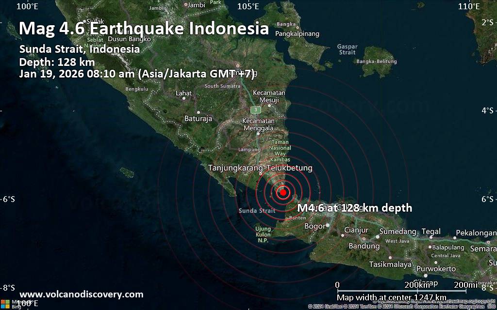 An earthquake of magnitude 4.6 occurred only 7 minutes ago 34 km northwest of Cilegon, Indonesia, Indonesia's Meteorology, Climatology, and Geophysical Agency reported.
The quake hit at an intermediate depth of 128. km beneath the epicenter near Cilegon, Kota Cilegon, Banten, Indonesia, in the morning on Monday, January 19th, 2026, at 8:10 am local time. The exact magnitude, epicenter, and depth of the quake might be revised within the next few hours or minutes as seismologists review data and refine their calculations, or as other agencies issue their report.
Our monitoring service identified a second report from the citizen-seismograph network of RaspberryShake which listed the quake at magnitude 4.6 as well.
Towns or cities near the epicenter where the quake might have been felt as very weak shaking include Cilegon (pop. 450,300) located 34 km from the epicenter, Pandeglang (pop. 92,300) 62 km away, Kresek (pop. 110,200) 72 km away, Bandar Lampung (pop. 1,166,100) 75 km away, Rangkasbitung (pop. 137,000) 76 km away, Pasarkemis (pop. 273,700) 89 km away, Cikupa (pop. 174,000) 90 km away, and Metro (pop. 178,400) 98 km away.
VolcanoDiscovery will automatically update magnitude and depth if these change and follow up if other significant news about the quake become available. If you’re in the area, please send us your experience through our reporting mechanism, either online or via our mobile app. This will help us provide more first-hand updates to anyone around the globe who wants to know more about this quake.
Earthquake data: Date & time: Jan 19, 2026 08:10 am (Jakarta time) local time (19 Jan 2026 01:10 GMT)Magnitude: 4.6 Depth: 128.00 km Epicenter latitude / longitude: 5.85°S / 105.79°E  (South Lampung Regency, Lampung, Indonesia) Primary data source: BMKGhttps://www.volcanodiscovery.com/earthquake/news/292291/Moderate-46-quake-hits-near-Cilegon-Kota-Cilegon-Banten-Indonesia.html
0
23
Read More
|
SPC Jan 19, 2026 0100 UTC Day 1 Convective Outlook
Webmaster
5 hours ago
SPC Jan 19, 2026 0100 UTC Day 1 Convective OutlookSPC 0100Z Day 1 Outlook 
Day 1 Convective Outlook
NWS Storm Prediction Center Norman OK
0654 PM CST Sun Jan 18 2026

Valid 190100Z - 191200Z

...NO THUNDERSTORM AREAS FORECAST...

...SUMMARY...
Thunderstorms are not forecast across the U.S. this evening and
tonight.

...DISCUSSION...
A large-scale upper-level trough will move across the east-central
U.S. tonight, as a cyclonic flow pattern remains in place over much
of nation. At the surface, a large area of high pressure will be
located over the Great Plains and Southeast. This dry and cold
airmass will make conditions unfavorable for thunderstorms today and
tonight across the continental U.S.

..Broyles.. 01/19/2026
Read morehttps://www.spc.noaa.gov/products/outlook/day1otlk_0100.html
0
5
Read More
|
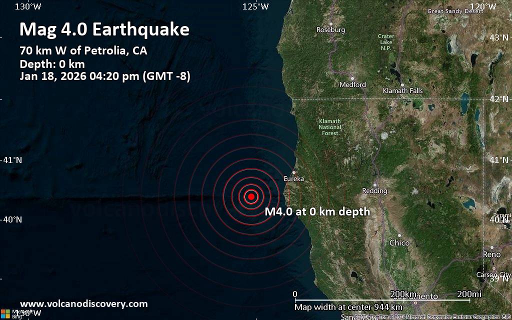
Moderate 4.0 quake hits near Eureka, Humboldt County, California, USA
Webmaster
5 hours ago
Moderate 4.0 quake hits near Eureka, Humboldt County, California, USAJust 7 minutes ago, a 4.0-magnitude earthquake struck near Eureka, Humboldt County, California, USA. The tremor was recorded in the afternoon on Sunday, January 18th, 2026, at 4:20 pm local time, at a very shallow depth of 0.2 miles below the surface.
The event was filed by the United States Geological Survey, the first seismological agency to report it.
A second report was later issued by the European-Mediterranean Seismological Centre (EMSC), which listed it as a magnitude 4.0 earthquake as well.
Towns or cities near the epicenter where the quake might have been felt as very weak shaking include Ferndale (pop. 1,400) located 46 miles from the epicenter, Fortuna (pop. 12,000) 52 miles away, Rio Dell (pop. 3,400) 53 miles away, Humboldt Hill (pop. 3,400) 54 miles away, Pine Hills (pop. 3,100) 56 miles away, Eureka (pop. 27,000) 57 miles away, and Myrtletown (pop. 4,700) 58 miles away.
Earthquake data: Date & time: Jan 19, 2026 12:20 am (Universal Time) local time (19 Jan 2026 00:20 GMT)Magnitude: 4.0 Depth: 0.35 km Epicenter latitude / longitude: 40.39°N / 125.11°W ( California, United States) Primary data source: USGShttps://www.volcanodiscovery.com/earthquake/news/292288/Moderate-40-quake-hits-near-Eureka-Humboldt-County-California-USA.html
0
17
Read More
|
World Earthquake Report for Sunday, 18 January 2026
Webmaster
5 hours ago
World Earthquake Report for Sunday, 18 January 2026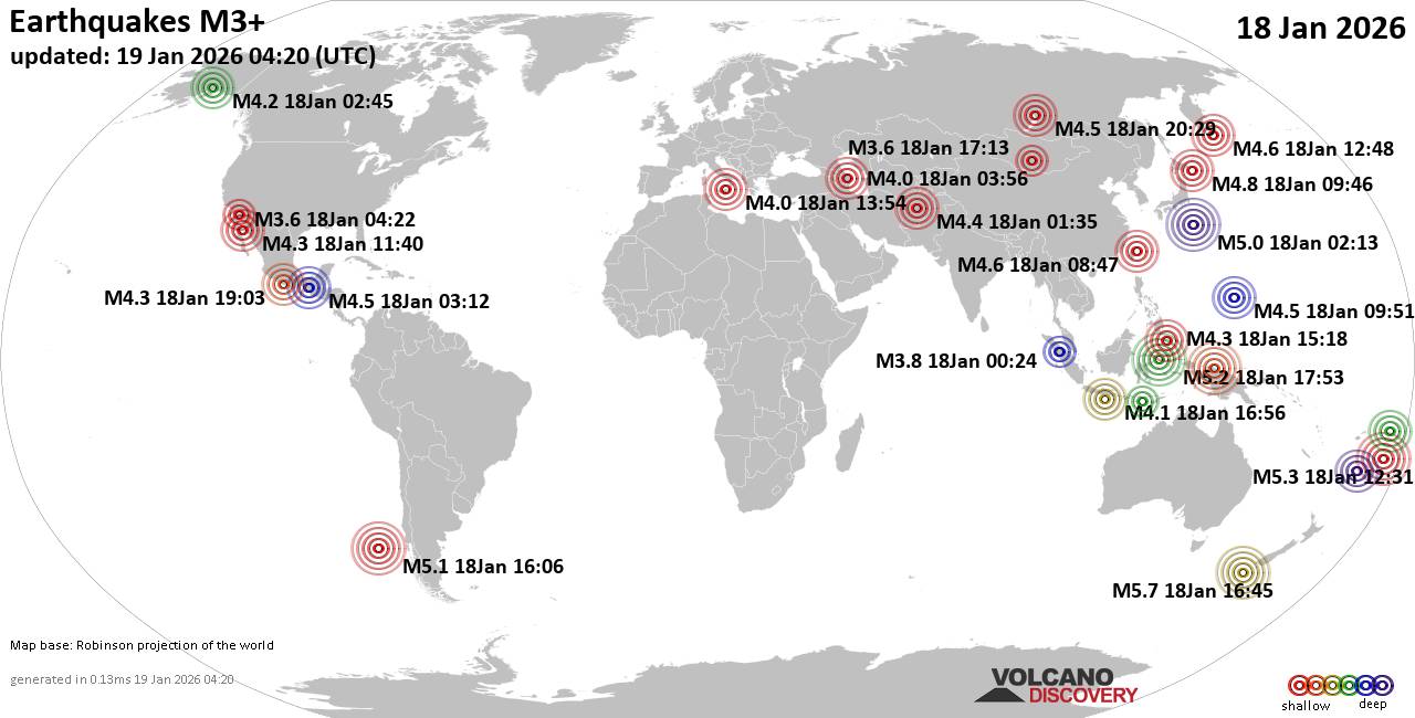 Worldwide earthquakes above magnitude 3 during the past 24 hours on 19 Jan 2026 Magnitude 5+: 6 earthquakes Magnitude 4+: 41 earthquakes Magnitude 3+: 131 earthquakes Magnitude 2+: 350 earthquakes No quakes of magnitude 6 or higher 10 largest earthquakes in the world (18 Jan 2026)Monday, Jan 19, 2026, at 05:45 am (GMT +13) - Monday, Jan 19, 2026, at 01:31 am (GMT +13) - Monday, Jan 19, 2026, at 01:53 am (GMT +8) - Sunday, Jan 18, 2026, at 11:06 am (GMT -5) - Sunday, Jan 18, 2026, at 03:38 pm (Jayapura time) - Sunday, Jan 18, 2026, at 11:13 am (GMT +9) - Sunday, Jan 18, 2026, at 10:15 am (Jayapura time) - Sunday, Jan 18, 2026, at 12:16 pm (GMT +8) - Sunday, Jan 18, 2026, at 07:46 pm (GMT +10) - Sunday, Jan 18, 2026, at 07:27 pm (GMT +8) - Earthquakes reported feltSunday, Jan 18, 2026, at 01:01 pm (GMT +2) - Sunday, Jan 18, 2026, at 02:54 pm (GMT +1) - Monday, Jan 19, 2026, at 07:52 am (GMT +13) - Sunday, Jan 18, 2026, at 06:54 am (GMT -8) - Sunday, Jan 18, 2026, at 01:06 am (GMT +1) - Saturday, Jan 17, 2026, at 05:45 pm (Anchorage time) - Sunday, Jan 18, 2026, at 12:16 pm (GMT +8) - Sunday, Jan 18, 2026, at 01:03 pm (Mexico City time) - Sunday, Jan 18, 2026, at 08:21 am (GMT -8) - Sunday, Jan 18, 2026, at 07:51 pm (GMT +10) - Monday, Jan 19, 2026, at 05:45 am (GMT +13) - Saturday, Jan 17, 2026, at 10:28 pm (GMT -5) - Sunday, Jan 18, 2026, at 07:56 am (GMT +4) - Sunday, Jan 18, 2026, at 04:02 pm (GMT +6:30) - Sunday, Jan 18, 2026, at 10:34 pm (GMT +8) - Sunday, Jan 18, 2026, at 11:55 am (GMT +8) - Sunday, Jan 18, 2026, at 06:05 am (GMT +4:30) - Sunday, Jan 18, 2026, at 11:13 am (GMT +9) - Earthquake stats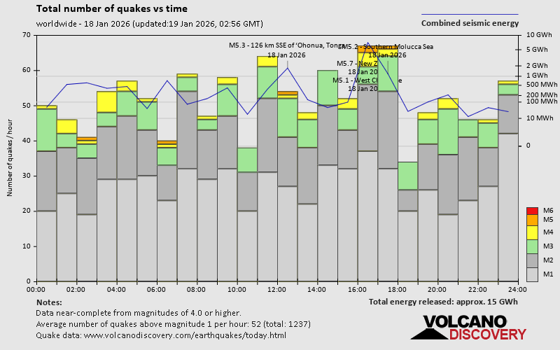 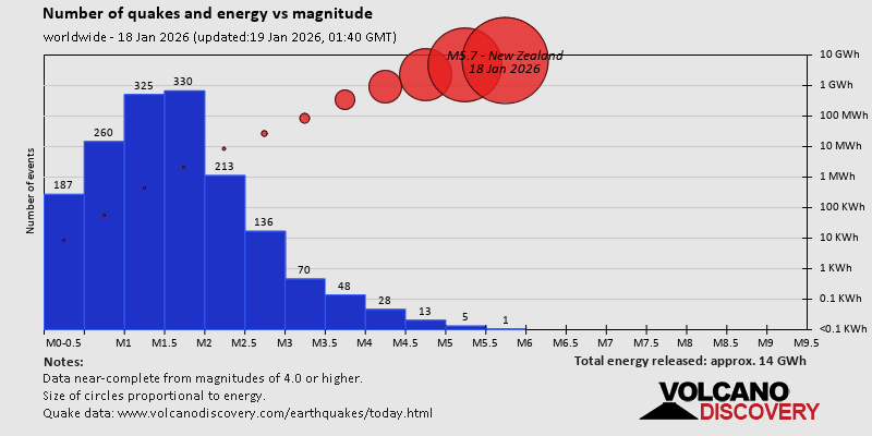 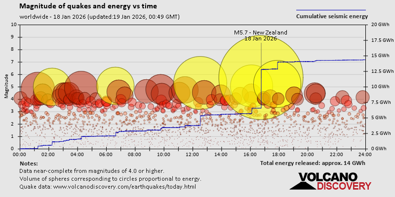 https://www.volcanodiscovery.com/earthquake/news/292231/World-Earthquake-Report-for-Sunday-18-January-2026.html https://www.volcanodiscovery.com/earthquake/news/292231/World-Earthquake-Report-for-Sunday-18-January-2026.html
0
15
Read More
|
Volcano earthquake report for Sunday, 18 Jan 2026
Webmaster
Yesterday at 11:50 PM
Volcano earthquake report for Sunday, 18 Jan 2026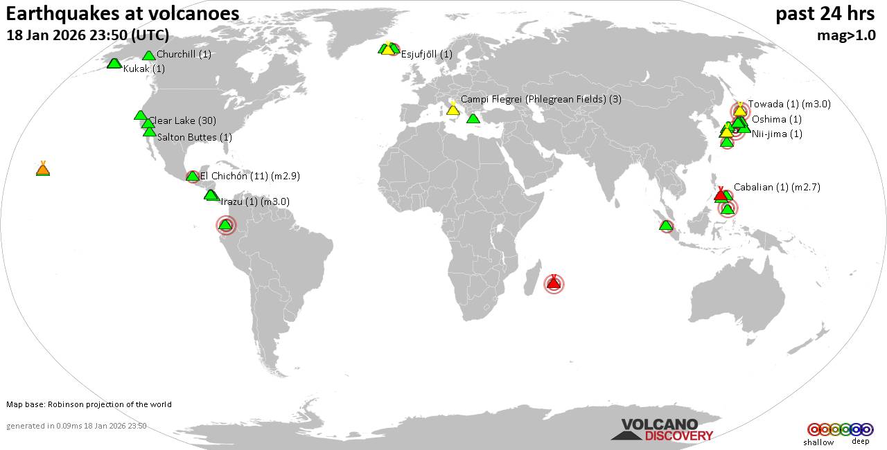 World map showing volcanoes with shallow (less than 50 km) earthquakes within 20 km radius during the past 24 hours on 18 Jan 2026 Number in brackets indicate nr of quakes. Quakes detected near: Abu (23 quakes between mag 0.1-1.2), Akuseki-jima (1 quake mag 2.1), Arenal (1 quake mag 1.9), Aso (5 quakes between mag 0.2-1.0), Balut (1 quake mag 3.0), Bardarbunga (2 quakes between mag 0.7-1.5)
Cabalian (1 quake mag 2.7), Campi Flegrei (Phlegrean Fields) (3 quakes between mag 0.1-1.4), Canlaon (1 quake mag 1.8), Churchill (1 quake mag 1.2), Clear Lake (30 quakes between mag 0.2-1.3), Coso (9 quakes between mag 0.5-1.5), Cuernos de Negros (1 quake mag 3.0), El Chichón (11 quakes between mag 2.2-2.9), Esjufjöll (1 quake mag 2.0), Guagua Pichincha (1 quake mag 3.0), Hiuchi (2 quakes between mag 0.1-1.3), Hrómundartindur (2 quakes between mag 0.8-1.1), Irazu (1 quake mag 3.0), Katla (1 quake mag 1.5), Katmai (2 quakes between mag 0.7-1.3), Kilauea (5 quakes between mag 1.7-1.9), Kukak (1 quake mag 1.1), Loihi (2 quakes between mag 1.7-2.2), Miravalles (1 quake mag 2.5), Myoko (31 quakes between mag 0.1-2.1), Nii-jima (1 quake mag 1.2), Norikura (10 quakes between mag 0.2-1.1), Novarupta (7 quakes between mag 0.6-1.2), Oshima (1 quake mag 1.0), Piton de la Fournaise (41 quakes between mag 0.0-3.3), Salton Buttes (1 quake mag 1.0), Sanbe (1 quake mag 3.0), Snowy Mountain (4 quakes between mag 0.9-2.3), Sousaki (1 quake mag 1.7), Tandikat (1 quake mag 2.1), Tenorio (1 quake mag 3.0), To-shima (1 quake mag 1.5), Torfajökull (2 quakes between mag 1.5-1.7), Towada (1 quake mag 3.0), Unzen (1 quake mag 1.1), Washiba-Kumonotaira (39 quakes between mag 0.1-1.9) (updated 23h50)
Note: Earthquakes within 20 km from and at depths less than 50 km under active volcanoes are reported. The list is not complete because many volcanoes are not monitored and/or seismic data in high resolution is not available publicly.
Volcanoes with recent earthquakes above magnitude 2 or more than 10 quakes are listed below:
Abu volcano (Honshu): 23 earthquakes up to magnitude 1.2Possible earthquake swarm: 23 earthquakes occurred near (under) the volcano during 16 hours, the last being recorded quake 4 hours ago. Hypocenter depths ranged between 33.20 and 28.70 km. Earthquake details: (only 5 largest) 1.2 quake 30 km north of Yamaguchi, Yamaguchi, Japan, Jan 18, 2026 12:54 pm (GMT +9) (7 km SSW) 0.9 quake 29 km north of Yamaguchi, Yamaguchi, Japan, Jan 18, 2026 03:50 pm (GMT +9) (8 km SSW) 0.7 quake 30 km north of Yamaguchi, Yamaguchi, Japan, Jan 18, 2026 03:28 pm (GMT +9) (8 km S) 0.6 quake 29 km north of Yamaguchi, Yamaguchi, Japan, Jan 18, 2026 04:11 pm (GMT +9) (8 km S) 0.6 quake 30 km north of Yamaguchi, Yamaguchi, Japan, Jan 18, 2026 02:26 pm (GMT +9) (8 km SSW) All earthquakes at AbuAkuseki-jima volcano (Ryukyu Islands): magnitude 2.1 earthquakeA magnitude 2.1 earthquake occurred at the volcano 16 hours ago. The quake, which might be volcanic in origin, was located at a depth of 10.30 km depth at 14 km distance SSW from the volcano. Earthquake details: 2.1 quake East China Sea, Kagoshima-ken, 36 km southwest of Suwanose-jima Island, Japan, Jan 18, 2026 05:15 pm (GMT +9) (14 km SSW) All earthquakes at Akuseki-jimaBalut volcano (Mindanao): magnitude 3.0 earthquakeA magnitude 3.0 earthquake occurred at the volcano 15 hours ago. The quake, which might be volcanic in origin, was located at a depth of 10.00 km depth at 2 km distance N from the volcano. Earthquake details: Reported quake or seismic-like event: 30 km east of General Santos, Philippines, Jan 18, 2026 05:04 pm (GMT +8) (2 km N) All earthquakes at BalutCabalian volcano (Central Philippines): magnitude 2.7 earthquakeA magnitude 2.7 earthquake occurred at the volcano 3 hours ago. The quake, which might be volcanic in origin, was located at a depth of 1.00 km depth at 11 km distance WNW from the volcano. Earthquake details: 2.7 quake 40 km northeast of Maasin, Philippines, Jan 19, 2026 04:52 am (GMT +8) (11 km WNW) All earthquakes at CabalianClear Lake volcano (California): 30 earthquakes up to magnitude 1.3Possible earthquake swarm: 30 earthquakes occurred near (under) the volcano during 20 hours, the last being recorded quake 4 hours ago. Hypocenter depths ranged between 14.82 and 0.70 km. Earthquake details: (only 5 largest) 1.3 quake 28 mi north of Santa Rosa, Sonoma County, California, United States, Jan 18, 2026 07:59 am (GMT -8) (16 km SSW) 1.3 quake 28 mi north of Santa Rosa, Sonoma County, California, United States, Jan 17, 2026 10:49 pm (GMT -8) (16 km SSW) 1.1 quake 27 mi north of Santa Rosa, Sonoma County, California, United States, Jan 18, 2026 01:30 am (GMT -8) (18 km SSW) 1.0 quake 28 mi north of Santa Rosa, Sonoma County, California, United States, Jan 17, 2026 03:56 pm (GMT -8) (18 km SSW) 1.0 quake 26 mi north of Santa Rosa, Sonoma County, California, United States, Jan 17, 2026 08:20 pm (GMT -8) (18 km S) All earthquakes at Clear LakeCuernos de Negros volcano (Central Philippines): magnitude 3.0 earthquakeA magnitude 3.0 earthquake occurred at the volcano 6 hours ago. The quake, which might be volcanic in origin, was located at a depth of 10.00 km depth at 11 km distance SE from the volcano. Earthquake details: Reported seismic-like event (likely no quake): 16 km southwest of Dumaguete, Philippines, Jan 19, 2026 02:14 am (GMT +8) (11 km SE) All earthquakes at Cuernos de NegrosEl Chichón volcano (Southern Mexico): 11 earthquakes up to magnitude 2.9Possible earthquake swarm: 11 earthquakes occurred near (under) the volcano during 17 hours, the last being recorded quake 6 hours ago. Hypocenter depths ranged between 3.70 and 1.30 km. Earthquake details: (only 5 largest) 2.9 quake Estado de Chiapas, 37 km southwest of Teapa, Estado de Tabasco, Mexico, Jan 18, 2026 11:44 am (GMT -6) (1 km WSW) 2.9 quake Estado de Chiapas, 47 km southwest of Teapa, Estado de Tabasco, Mexico, Jan 18, 2026 02:04 am (GMT -6) (11 km SSW) 2.9 quake Estado de Chiapas, 37 km southwest of Teapa, Estado de Tabasco, Mexico, Jan 18, 2026 02:46 am (GMT -6) (1 km WSW) 2.7 quake Estado de Chiapas, 36 km southwest of Teapa, Estado de Tabasco, Mexico, Jan 18, 2026 02:19 am (GMT -6) (1 km N) 2.6 quake Estado de Chiapas, 38 km southwest of Teapa, Estado de Tabasco, Mexico, Jan 18, 2026 02:54 am (GMT -6) (1 km SW) All earthquakes at El ChichónGuagua Pichincha volcano (Ecuador): magnitude 3.0 earthquakeA magnitude 3.0 earthquake occurred at the volcano 3 hours ago. The quake, which might be volcanic in origin, was located at a depth of 10.00 km depth at 11 km distance E from the volcano. Earthquake details: Reported seismic-like event (likely no quake): 6.6 km northeast of Quito, Provincia de Pichincha, Ecuador, Jan 18, 2026 03:34 pm (GMT -5) (11 km E) All earthquakes at Guagua PichinchaIrazu volcano (Costa Rica): magnitude 3.0 earthquakeA magnitude 3.0 earthquake occurred at the volcano 16 hours ago. The quake, which might be volcanic in origin, was located at a depth of 10.00 km depth at 18 km distance SSE from the volcano. Earthquake details: Reported seismic-like event (likely no quake): 7.4 km east of Paraiso, Provincia de Cartago, Costa Rica, Jan 18, 2026 01:23 am (GMT -6) (18 km SSE) All earthquakes at IrazuLoihi volcano (Hawai'i (Big Island)): 2 earthquakes up to magnitude 2.22 earthquakes occurred near (under) the volcano during 3 hours, the last being recorded quake 19 hours ago. Hypocenter depths ranged between 33.39 and 21.35 km. Earthquake details: 2.2 quake North Pacific Ocean, 15 mi southeast of Pāhala, Hawaii County, Hawaii, United States, Jan 17, 2026 04:19 pm (GMT -10) (14 km NW) 1.7 quake North Pacific Ocean, 41 mi southeast of of Hawai‘i Island, Hawaii County, Hawaii, United States, Jan 17, 2026 07:14 pm (GMT -10) (16 km NNW) All earthquakes at LoihiMiravalles volcano (Costa Rica): magnitude 2.5 earthquakeA magnitude 2.5 earthquake occurred at the volcano 21 hours ago. The quake, which might be volcanic in origin, was located at a depth of 9.00 km depth at 11 km distance SW from the volcano. Earthquake details: 2.5 quake 23 km east of Liberia, Provincia de Guanacaste, Costa Rica, Jan 17, 2026 09:14 pm (GMT -6) (11 km SW) All earthquakes at MiravallesMyoko volcano (Honshu): 31 earthquakes up to magnitude 2.1Possible earthquake swarm: 31 earthquakes occurred near (under) the volcano during 7 hours, the last being recorded quake 1 hour 45 minutes ago. Hypocenter depths ranged between 3.50 and 0.00 km. Earthquake details: (only 5 largest) 2.1 quake Niigata, 21 km northwest of Nagano, Nagano, Japan, Jan 19, 2026 02:58 am (GMT +9) (9 km SSW) 2.1 quake Niigata, 21 km northwest of Nagano, Nagano, Japan, Jan 19, 2026 01:00 am (GMT +9) (9 km SSW) 1.5 quake Niigata, 21 km northwest of Nagano, Nagano, Japan, Jan 19, 2026 02:58 am (GMT +9) (8 km SSW) 1.0 quake Niigata, 20 km northwest of Nagano, Nagano, Japan, Jan 19, 2026 06:10 am (GMT +9) (9 km SSW) 0.9 quake Niigata, 21 km northwest of Nagano, Nagano, Japan, Jan 19, 2026 06:32 am (GMT +9) (9 km SSW) All earthquakes at MyokoPiton de la Fournaise volcano (Indian Ocean): 41 earthquakes up to magnitude 3.3Possible earthquake swarm: 41 earthquakes occurred near (under) the volcano during 5 hours, the last being recorded quake 7 hours ago. Hypocenter depths ranged between 1.50 and 0.10 km. Earthquake details: (only 5 largest) 3.3 quake 49 km southeast of Saint-Denis, Reunion, Jan 18, 2026 06:39 pm (GMT +4) (1 km SSE) 1.6 quake 21 km east of Le Tampon, Reunion, Jan 18, 2026 06:18 pm (GMT +4) (1 km E) 1.4 quake 48 km southeast of Saint-Denis, Reunion, Jan 18, 2026 07:06 pm (GMT +4) (0 km N) 1.3 quake 48 km southeast of Saint-Denis, Reunion, Jan 18, 2026 04:56 pm (GMT +4) (1 km N) 1.2 quake 49 km southeast of Saint-Denis, Reunion, Jan 18, 2026 04:53 pm (GMT +4) (1 km NE) All earthquakes at Piton de la FournaiseSanbe volcano (Honshu): magnitude 3.0 earthquakeA magnitude 3.0 earthquake occurred at the volcano 17 hours ago. The quake, which might be volcanic in origin, was located at a depth of 10.00 km depth at 17 km distance ESE from the volcano. Earthquake details: Reported seismic-like event (likely no quake): 25 km east of Anan, Tokushima, Japan, Jan 18, 2026 04:19 pm (GMT +9) (17 km ESE) All earthquakes at SanbeSnowy Mountain volcano (Alaska Peninsula): 4 earthquakes up to magnitude 2.34 earthquakes occurred near (under) the volcano during 4 hours, the last being recorded quake 18 hours ago. Hypocenter depths ranged between 8.80 and 0.00 km. Earthquake details: 2.3 quake Lake and Peninsula Borough, 99 mi northwest of Kodiak, Kodiak Island Borough, Alaska, United States, Jan 17, 2026 04:56 pm (GMT -9) (13 km NW) 1.6 quake Lake and Peninsula Borough, 99 mi northwest of Kodiak, Kodiak Island Borough, Alaska, United States, Jan 17, 2026 05:00 pm (GMT -9) (15 km NW) 1.2 quake Lake and Peninsula Borough, 99 mi northwest of Kodiak, Kodiak Island Borough, Alaska, United States, Jan 17, 2026 08:41 pm (GMT -9) (14 km NW) 0.9 quake Lake and Peninsula Borough, 98 mi northwest of Kodiak, Kodiak Island Borough, Alaska, United States, Jan 17, 2026 05:23 pm (GMT -9) (11 km NW) All earthquakes at Snowy MountainTandikat volcano (Sumatra): magnitude 2.1 earthquakeA magnitude 2.1 earthquake occurred at the volcano 7 hours ago. The quake, which might be volcanic in origin, was located at a depth of 3.00 km depth at 13 km distance SE from the volcano. Earthquake details: 2.1 quake Kabupaten Tanah Datar, 4.9 km south of Padangpanjang, Indonesia, Jan 19, 2026 12:13 am (GMT +7) (13 km SE) All earthquakes at TandikatTenorio volcano (Costa Rica): magnitude 3.0 earthquakeA magnitude 3.0 earthquake occurred at the volcano 19 hours ago. The quake, which might be volcanic in origin, was located at a depth of 10.00 km depth at 6 km distance NW from the volcano. Earthquake details: Reported seismic-like event (likely no quake): 28 km south of San José, Provincia de Alajuela, Costa Rica, Jan 17, 2026 11:02 pm (GMT -6) (6 km NW) All earthquakes at TenorioTowada volcano (Honshu): magnitude 3.0 earthquakeA magnitude 3.0 earthquake occurred at the volcano 19 hours ago. The quake, which might be volcanic in origin, was located at a depth of 10.00 km depth at 5 km distance NNW from the volcano. Earthquake details: Reported seismic-like event (likely no quake): 39 km northeast of Odate, Akita, Japan, Jan 18, 2026 01:55 pm (GMT +9) (5 km NNW) All earthquakes at TowadaWashiba-Kumonotaira volcano (Honshu): 39 earthquakes up to magnitude 1.9Possible earthquake swarm: 39 earthquakes occurred near (under) the volcano during 22 hours, the last being recorded quake 2 hours ago. Hypocenter depths ranged between 12.70 and 0.00 km. Earthquake details: (only 5 largest) 1.9 quake 26 km west of Azumino, Nagano, Japan, Jan 18, 2026 10:23 pm (GMT +9) (5 km SSE) 1.7 quake 27 km northwest of Azumino, Nagano, Japan, Jan 18, 2026 08:41 pm (GMT +9) (3 km SE) 1.4 quake 23 km northwest of Azumino, Nagano, Japan, Jan 19, 2026 03:47 am (GMT +9) (6 km SE) 1.3 quake Gifu, 25 km west of Azumino, Nagano, Japan, Jan 18, 2026 08:58 am (GMT +9) (7 km SSE) 1.1 quake 25 km west of Azumino, Nagano, Japan, Jan 19, 2026 12:00 am (GMT +9) (5 km SSE) All earthquakes at Washiba-Kumonotairahttps://www.volcanodiscovery.com/earthquakes-volcanoes/news/292216/Volcano-earthquake-report-for-Sunday-18-Jan-2026.html
0
4
Read More
|
Tuesday: Light Cloud, Minimum Temperature: 6°C (43°F) Maximum Temperature: 10°C (50°F)
Webmaster
Yesterday at 10:01 PM
Maximum Temperature: 10°C (50°F), Minimum Temperature: 6°C (43°F), Wind Direction: South Easterly, Wind Speed: 11mph, Visibility: Very Good, Pressure: 1010mb, Humidity: 82%, UV Risk: 1, Pollution: Low, Sunrise: 08:12 GMT, Sunset: 16:29 GMT Source: Tuesday: Light Cloud, Minimum Temperature: 6°C (43°F) Maximum Temperature: 10°C (50°F)
0
14
Read More
|
Monday: Light Rain, Minimum Temperature: 6°C (44°F) Maximum Temperature: 10°C (50°F)
Webmaster
Yesterday at 10:01 PM
Maximum Temperature: 10°C (50°F), Minimum Temperature: 6°C (44°F), Wind Direction: South Easterly, Wind Speed: 3mph, Visibility: Poor, Pressure: 1013mb, Humidity: 93%, UV Risk: 1, Pollution: Low, Sunrise: 08:13 GMT, Sunset: 16:27 GMT Source: Monday: Light Rain, Minimum Temperature: 6°C (44°F) Maximum Temperature: 10°C (50°F)
0
19
Read More
|
World Earthquake Report for January 2026
Webmaster
Yesterday at 07:00 PM
World Earthquake Report for January 2026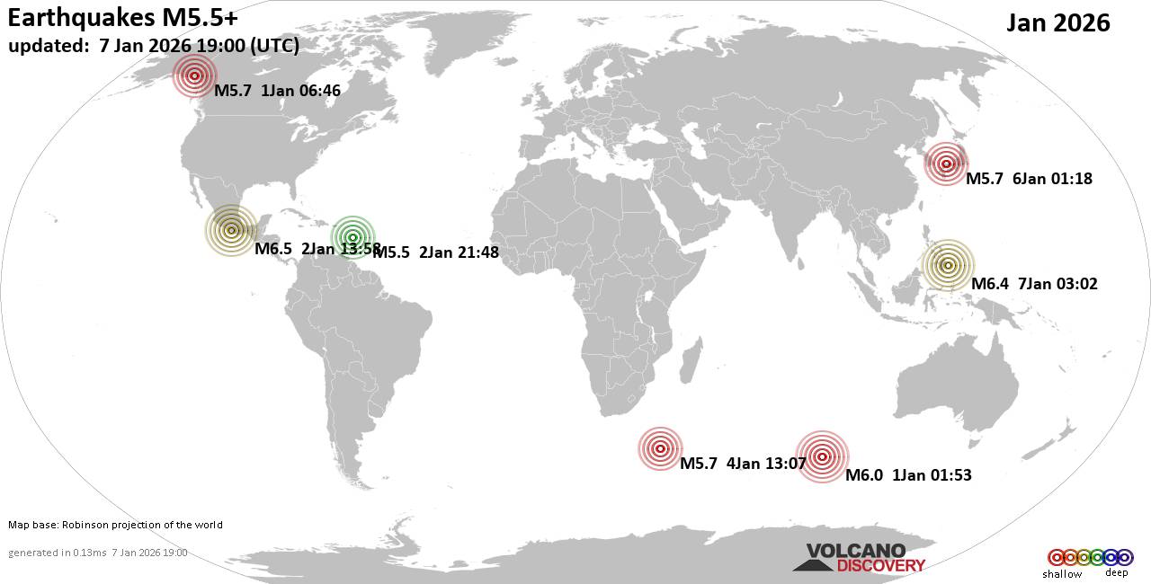 Worldwide earthquakes above magnitude 5.5 during January 2026 Magnitude 9+: none Magnitude 8+: none Magnitude 7+: none Magnitude 6+: 6 earthquakes Magnitude 5+: 92 earthquakes Magnitude 4+: 760 earthquakes Magnitude 3+: 3470 earthquakes Magnitude 2+: 7679 earthquakes No quakes of magnitude 7 or higher List of 10 largest earthquakes in the world during January 2026:Friday, Jan 2, 2026, at 07:58 am (Mexico City time) - Wednesday, Jan 7, 2026, at 11:02 am (Manila time) - Thursday, Jan 1, 2026, at 07:53 am (GMT +6) - Saturday, Jan 3, 2026, at 04:07 pm (GMT +6) - Wednesday, Dec 31, 2025, at 11:46 pm (Whitehorse time) - Tuesday, Jan 6, 2026, at 10:18 am (GMT +9) - Sunday, Jan 4, 2026, at 04:07 pm (GMT +3) - Friday, Jan 2, 2026, at 05:48 pm (GMT -4) - Wednesday, Jan 7, 2026, at 12:12 pm (GMT +8) - Earthquake stats: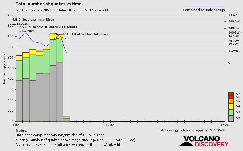 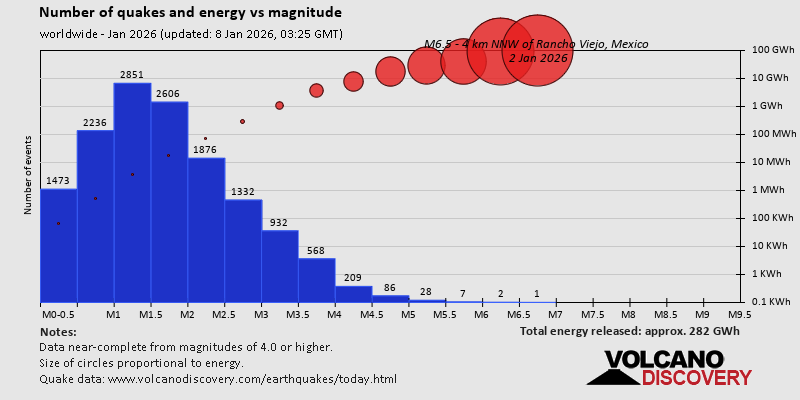 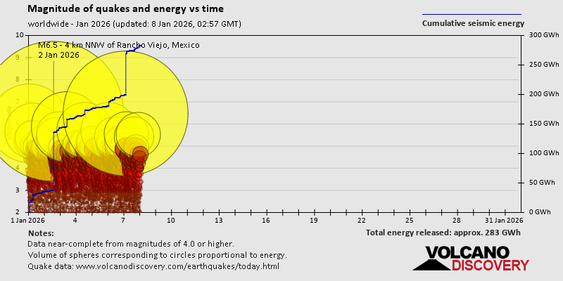 https://www.volcanodiscovery.com/view_news/290900/World-Earthquake-Report-for-January-2026.html https://www.volcanodiscovery.com/view_news/290900/World-Earthquake-Report-for-January-2026.html
0
4
Read More
|
|
Forums60
Topics757,123
Posts791,829
Members2,958
| |
Most Online17,963
Jan 15th, 2026
|
|
|
|
|
Copyright 1996 - 2026 by David Cottle. Designed by David Bate Jr. All Rights Reserved.
By using this forum, the user agrees not to transfer any data or technical information received under the agreement, to any other entity without the express approval of the AUS-CITY Forum Admins and/or authors of individual posts (Forum Admins and DoD/USSPACECOM for the analysis of satellite tracking data).
Two-line elements (TLE) and all other satellite data presented and distributed via this forum and e-mail lists of AUS-CITY are distributed with permission from DoD/USSTRATCOM.


Reprise Hosting

|

|


 - Click image for larger picture.")


