|
|
|
0 members (),
2,874
guests, and
26
robots. |
|
Key:
Admin,
Global Mod,
Mod
|
|
S |
M |
T |
W |
T |
F |
S |
|
|
|
|
1
|
2
|
3
|
4
|
|
5
|
6
|
7
|
8
|
9
|
10
|
11
|
|
12
|
13
|
14
|
15
|
16
|
17
|
18
|
|
19
|
20
|
21
|
22
|
23
|
24
|
25
|
|
26
|
27
|
28
|
29
|
30
|
|
|
|
There are no members with birthdays on this day. |
 DTM 2026: Full 21-car entry list
Webmaster
5 hours ago
DTM 2026: Full 21-car entry list
Webmaster
5 hours ago
Following the end of the registration deadline on 31 March, the DTM has announced the full entry list for its 2026 season. A total of 21 cars from eight manufacturers will take to the track this year. For comparison, there were 24 cars from nine manufacturers in the series last year. "The quality of the DTM driver line-up is tremendous, and drivers from eleven nations underscore the ... Keep readingSource: DTM 2026: Full 21-car entry list
0
5
Read More
|
SPC Apr 1, 2026 1300 UTC Day 1 Convective Outlook
Webmaster
7 hours ago
SPC Apr 1, 2026 1300 UTC Day 1 Convective OutlookSPC 1300Z Day 1 Outlook 
Day 1 Convective Outlook
NWS Storm Prediction Center Norman OK
0751 AM CDT Wed Apr 01 2026

Valid 011300Z - 021200Z

...THERE IS AN ENHANCED RISK OF SEVERE THUNDERSTORMS ACROSS
NORTHWEST TEXAS...WESTERN/CENTRAL OKLAHOMA...AND SOUTH-CENTRAL
KANSAS...

...THERE IS A SLIGHT RISK OF SEVERE THUNDERSTORMS PORTIONS OF THE
MIDDLE OHIO VALLEY AND MID-ATLANTIC...

...SUMMARY...
Severe thunderstorms with damaging wind gusts, large hail and a few
tornadoes are likely across the southern and central Plains this
afternoon and evening. Strong to severe storms are also possible
from parts of the Ohio Valley, central Appalachians and
Mid-Atlantic.

...Synopsis...
Early morning radar and satellite imagery shows a cluster of
thunderstorms moving through central MO, just to the north and east
of a surface low over far southwest MO. Surface analysis shows a
cold front extending from this low northeastward across the OH
Valley and Northeast to another low over NH. A stationary boundary
also extends southwestward from the southwest MO low across central
and southwest OK, and northwest TX to another low over the Permian
Basin. Thunderstorms are expected to focus on each of these
boundaries today, particularly from the middle OH Valley into the
Mid-Atlantic and over large portion of the central/southern Plains
and Mid MS Valley. Severe thunderstorms are possible across these
regions as well, with the highest severe thunderstorm coverage
expected from northwest TX through western OK into south-central KS.

...Central/Southern Plains...
Low-level moisture advection is anticipated across the southern
Plains today as the shortwave trough currently moving through the
southern Great Basin continues quickly eastward, reaching the
central Plains by early tomorrow. General expectation is for the
stationary boundary mentioned in the synopsis to push north as warm
front and for mid 60s dewpoints to cover much of OK by the late
afternoon. This increasing low-level moisture beneath steep lapse
rates (over 7 to 7.5 deg C per 12Z soundings and recent
mesoanalysis) will support moderate to strong buoyancy from
southwest TX into much of central and western OK. Height falls
attendant to the approaching shortwave will begin spreading over
this destabilizing airmass by the early afternoon, combining with
low-level convergence along the front and dryline to support
convective initiation between 21Z and 00Z.

Given the expectation that convective inhibition will be limited, if
present at all, widespread development is anticipated from western
OK into southwest TX. Kinematic profiles support supercells, but the
persistent ascent and extensive nature of the convective initiation
suggest that a discrete convective mode will be difficult to
maintain and a quick transition to a convective line appears
probable. As such, strong gusts appear to be the primary severe
risk. Even so, steep lapse rates should still support large hail,
even within the convective line. Very large hail (i.e. 2"+ in
diameter) is possible if a discrete mode can be maintained. A
discrete mode could also increase the tornado potential, but higher
probabilities (i.e. 10%) were not introduced given the likely storm
interactions and expected quick convective evolution into a line.
Some tornado risk will still be present within the line,
particularly during the 00-04Z period as low-level hodographs
lengthen amid a strengthening low-level jet.

This strengthening low-level jet is also expected to support a
secondary area of thunderstorm development from northeast
OK/southeast KS into central/southern MO during the late afternoon.
Large hail (with some isolated instances of hail around 2") is the
primary risk with these storms, most likely early in their
convective cycles.

...Ohio Valley into Mid-Atlantic...
Ongoing cluster over MO will gradually move eastward with time, with
the airmass south of the front mentioned in the synopsis
destabilizing throughout the day. This destabilization coupled with
moderate westerly flow aloft could lead to a reintensification of
this cluster and/or new development ahead of it. Vertical shear will
be modest but still sufficient for bowing line segments capable of
damaging gusts. Greatest storm coverage (and attendant greatest
severe potential) is expected over the middle Ohio Valley and the
Mid-Atlantic States.

..Mosier/Bentley.. 04/01/2026
Read morehttps://www.spc.noaa.gov/products/outlook/day1otlk_1300.html
0
13
Read More
|
Volcano earthquake report for Wednesday, 1 Apr 2026
Webmaster
7 hours ago
Volcano earthquake report for Wednesday, 1 Apr 2026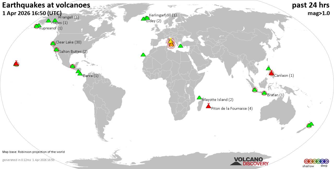 World map showing volcanoes with shallow (less than 50 km) earthquakes within 20 km radius during the past 24 hours on 1 Apr 2026 Number in brackets indicate nr of quakes. Quakes detected near: Aniakchak (1 quake mag 1.0), Barva (1 quake mag 2.1), Bratan (2 quakes between mag 2.0-2.4), Campi Flegrei (Phlegrean Fields) (2 quakes between mag 0.7-3.0), Canlaon (1 quake mag 2.4), Clear Lake (29 quakes between mag 0.2-2.1)
El Chichón (6 quakes between mag 2.2-3.0), Eldey (2 quakes between mag 1.4-1.5), Etna (1 quake mag 3.0), Hayes (1 quake mag 1.0), Hiuchi (1 quake mag 3.0), Hulubelu (3 quakes between mag 2.5-2.5), Kerlingarfjöll (1 quake mag 1.1), Kilauea (3 quakes between mag 1.7-2.2), Kolumbo (2 quakes between mag 1.2-1.6), Loihi (2 quakes between mag 1.7-2.1), Loki-Fögrufjöll volcano (3 quakes between mag 0.9-1.3), Maunaloa (1 quake mag 2.7), Mayotte Island (1 quake mag 1.2), Piton de la Fournaise (5 quakes between mag 0.5-1.4), Ruapehu (1 quake mag 2.0), Salton Buttes (2 quakes between mag 2.1-2.4), Stepovak Bay 4 (2 quakes between mag 1.4-2.3), Tenerife (5 quakes between mag 0.9-1.7), Wrangell (1 quake mag 1.5) (updated 12h50)
Note: Earthquakes within 20 km from and at depths less than 50 km under active volcanoes are reported. The list is not complete because many volcanoes are not monitored and/or seismic data in high resolution is not available publicly.
Volcanoes with recent earthquakes above magnitude 2 or more than 10 quakes are listed below:
Barva volcano (Costa Rica): magnitude 2.1 earthquakeA magnitude 2.1 earthquake occurred at the volcano 6 hours ago. The quake, which might be volcanic in origin, was located at a depth of 16.00 km depth at 15 km distance ENE from the volcano. Earthquake details: 2.1 quake Provincia de Heredia, 31 km northeast of San Jose, Costa Rica, Apr 1, 2026 01:14 am (Costa_Rica time) (15 km ENE) All earthquakes at BarvaBratan volcano (Bali): 2 earthquakes up to magnitude 2.42 earthquakes occurred near (under) the volcano during 2 hours, the last being recorded quake 18 hours ago. Hypocenter depths ranged between 10.00 and 10.00 km. Earthquake details: 2.4 quake Kabupaten Tabanan, 16 km south of Banjar, Indonesia, Apr 1, 2026 02:36 am (GMT +8) (17 km WSW) 2.0 quake Kabupaten Tabanan, 15 km south of Banjar, Indonesia, Apr 1, 2026 12:31 am (GMT +8) (17 km WSW) All earthquakes at BratanCampi Flegrei (Phlegrean Fields) volcano (Italy): 2 earthquakes up to magnitude 3.02 earthquakes occurred near (under) the volcano during 3 hours, the last being recorded quake 19 hours ago. Hypocenter depths ranged between 10.00 and 2.00 km. Earthquake details: Reported seismic-like event (likely no quake): 4.1 km west of Naples, Napoli, Campania, Italy, Mar 31, 2026 07:47 pm (GMT +2) (7 km ENE) 0.7 quake 3.3 km southwest of Pianura, Napoli, Campania, Italy, Mar 31, 2026 04:23 pm (GMT +2) (2 km N) All earthquakes at Campi Flegrei (Phlegrean Fields)Canlaon volcano (Central Philippines): magnitude 2.4 earthquakeA magnitude 2.4 earthquake occurred at the volcano 18 hours ago. The quake, which might be volcanic in origin, was located at a depth of 14.00 km depth at 10 km distance NW from the volcano. Earthquake details: 2.4 quake 9.7 km east of Maao, Province of Negros Occidental, Western Visayas, Philippines, Apr 1, 2026 02:58 am (GMT +8) (10 km NW) All earthquakes at CanlaonClear Lake volcano (California): 29 earthquakes up to magnitude 2.1Possible earthquake swarm: 29 earthquakes occurred near (under) the volcano during 21 hours, the last being recorded quake 1 hour 4 minutes ago. Hypocenter depths ranged between 33.24 and 0.59 km. Earthquake details: (only 5 largest) 2.1 quake Sonoma County, 14 mi southwest of Clearlake, Lake County, California, United States, Apr 1, 2026 03:34 am (GMT -7) (16 km SSW) 1.9 quake 26 mi north of Santa Rosa, Sonoma County, California, United States, Mar 31, 2026 06:54 pm (GMT -7) (19 km SSW) 1.6 quake 12 mi southwest of Clearlake, Lake County, California, United States, Mar 31, 2026 07:05 pm (GMT -7) (15 km S) 1.5 quake Sonoma County, 14 mi southwest of Clearlake, Lake County, California, United States, Apr 1, 2026 04:46 am (GMT -7) (18 km S) 1.3 quake Lake County, 26 mi north of Santa Rosa, Sonoma County, California, United States, Mar 31, 2026 11:17 pm (GMT -7) (17 km S) All earthquakes at Clear LakeEl Chichón volcano (Southern Mexico): 6 earthquakes up to magnitude 3.06 earthquakes occurred near (under) the volcano during 17 hours, the last being recorded quake 3 hours ago. Hypocenter depths ranged between 3.20 and 2.50 km. Earthquake details: (only 5 largest) 3.0 quake Estado de Chiapas, 37 km southwest of Teapa, Estado de Tabasco, Mexico, Apr 1, 2026 04:18 am (GMT -6) (1 km WSW) 2.7 quake Estado de Chiapas, 37 km southwest of Teapa, Estado de Tabasco, Mexico, Mar 31, 2026 01:53 pm (GMT -6) (1 km NNW) 2.6 quake Estado de Chiapas, 37 km southwest of Teapa, Estado de Tabasco, Mexico, Mar 31, 2026 01:25 pm (GMT -6) (1 km WNW) 2.5 quake Estado de Chiapas, 37 km southwest of Teapa, Estado de Tabasco, Mexico, Mar 31, 2026 03:52 pm (GMT -6) (0 km N) 2.4 quake Estado de Chiapas, 37 km southwest of Teapa, Estado de Tabasco, Mexico, Mar 31, 2026 11:24 am (GMT -6) (0 km NNE) All earthquakes at El ChichónEtna volcano (Italy): magnitude 3.0 earthquakeA magnitude 3.0 earthquake occurred at the volcano 14 hours ago. The quake, which might be volcanic in origin, was located at a depth of 10.00 km depth at 17 km distance SW from the volcano. Earthquake details: Reported seismic-like event (likely no quake): 25 km northwest of Catania, Catania, Sicily, Italy, Apr 1, 2026 12:48 am (GMT +2) (17 km SW) All earthquakes at EtnaHiuchi volcano (Honshu): magnitude 3.0 earthquakeA magnitude 3.0 earthquake occurred at the volcano 22 hours ago. The quake, which might be volcanic in origin, was located at a depth of 10.00 km depth at 8 km distance NNW from the volcano. Earthquake details: Unconfirmed earthquake or seismic-like event: 36 km southeast of Uonuma, Niigata, Japan, Apr 1, 2026 12:13 am (GMT +9) (8 km NNW) All earthquakes at HiuchiHulubelu volcano (Sumatra): 3 earthquakes up to magnitude 2.53 earthquakes occurred near (under) the volcano during 8 minutes, the last being recorded quake 7 hours ago. Hypocenter depths ranged between 4.00 and 3.00 km. Earthquake details: 2.5 quake Kabupaten Tanggamus, 74 km west of Bandar Lampung, Indonesia, Apr 1, 2026 01:01 pm (GMT +7) (9 km S) 2.5 quake Kabupaten Tanggamus, 78 km west of Bandar Lampung, Indonesia, Apr 1, 2026 12:59 pm (GMT +7) (13 km S) 2.5 quake Kabupaten Tanggamus, 75 km west of Bandar Lampung, Indonesia, Apr 1, 2026 12:53 pm (GMT +7) (2 km SSE) All earthquakes at HulubeluKilauea volcano (Hawai'i (Big Island)): 3 earthquakes up to magnitude 2.23 earthquakes occurred near (under) the volcano during 22 hours, the last being recorded quake 52 minutes ago. Hypocenter depths ranged between 28.65 and 5.12 km. Earthquake details: 2.2 quake 29 mi south of Hilo, Hawaii County, Hawaii, United States, Apr 1, 2026 01:58 am (GMT -10) (13 km SE) 1.9 quake 35 mi southwest of Hilo, Hawaii County, Hawaii, United States, Mar 31, 2026 10:21 am (GMT -10) (17 km WSW) 1.7 quake 21 mi southwest of Hilo, Hawaii County, Hawaii, United States, Mar 31, 2026 03:52 am (GMT -10) (8 km NE) All earthquakes at KilaueaLoihi volcano (Hawai'i (Big Island)): 2 earthquakes up to magnitude 2.12 earthquakes occurred near (under) the volcano during 9 hours, the last being recorded quake 11 hours ago. Hypocenter depths ranged between 32.81 and 31.60 km. Earthquake details: 2.1 quake North Pacific Ocean, 12 mi southeast of Pāhala, Hawaii County, Hawaii, United States, Mar 31, 2026 03:22 pm (GMT -10) (19 km NW) 1.7 quake North Pacific Ocean, 40 mi southeast of of Hawai‘i Island, Hawaii County, Hawaii, United States, Mar 31, 2026 06:18 am (GMT -10) (17 km NW) All earthquakes at LoihiMaunaloa volcano (Hawai'i (Big Island)): magnitude 2.7 earthquakeA magnitude 2.7 earthquake occurred at the volcano 20 minutes ago. The quake, which might be volcanic in origin, was located at a depth of 2.05 km depth at 11 km distance E from the volcano. Earthquake details: 2.7 quake 32 mi southwest of Hilo, Hawaii County, Hawaii, United States, Apr 1, 2026 02:30 am (GMT -10) (11 km E) All earthquakes at MaunaloaSalton Buttes volcano (California): 2 earthquakes up to magnitude 2.42 earthquakes occurred near (under) the volcano during 34 seconds, the last being recorded quake 5 hours ago. Hypocenter depths ranged between 3.29 and 3.22 km. Earthquake details: 2.4 quake 14 mi northwest of Brawley, Imperial County, California, United States, Apr 1, 2026 01:04 am (GMT -7) (4 km SSW) 2.1 quake 14 mi northwest of Brawley, Imperial County, California, United States, Apr 1, 2026 01:04 am (GMT -7) (5 km SSW) All earthquakes at Salton ButtesStepovak Bay 4 volcano (Alaska Peninsula): 2 earthquakes up to magnitude 2.32 earthquakes occurred near (under) the volcano during 18 minutes, the last being recorded quake 9 hours ago. Hypocenter depths ranged between 10.10 and 8.50 km. Earthquake details: 2.3 quake Lake and Peninsula Borough, 49 mi northeast of Sand Point, Aleutians East Borough, Alaska, United States, Mar 31, 2026 07:41 pm (GMT -8) (11 km ESE) 1.4 quake Lake and Peninsula Borough, 49 mi northeast of Sand Point, Aleutians East Borough, Alaska, United States, Mar 31, 2026 08:00 pm (GMT -8) (9 km ESE) All earthquakes at Stepovak Bay 4Unnamed 24.00°N/121.83°E volcano (Taiwan): magnitude 4.2 earthquakeA magnitude 4.2 earthquake occurred at the volcano 21 hours ago. The quake, which might be volcanic in origin, was located at a depth of 16.80 km depth at 12 km distance ESE from the volcano. Earthquake details: 4.2 quake Philippine Sea, 33 km east of Hualien City, Taiwan, Mar 31, 2026 11:43 pm (Taipei time) (12 km ESE) All earthquakes at Unnamed 24.00°N/121.83°Ehttps://www.volcanodiscovery.com/earthquakes-volcanoes/news/298987/Volcano-earthquake-report-for-Wednesday-1-Apr-2026.html
0
17
Read More
|
Arjun, son of Sachin, makes honest admission: 'I don't have cricketer friends'
Webmaster
7 hours ago
Arjun Tendulkar, now with Lucknow Super Giants, shared insights into his simple personal life, saying he spends time with his dogs and has few cricketer friends. Unfazed by trolling, he said, "No, I'm not" scared of criticism. After limited chances at Mumbai Indians, he faces fresh competition but hopes to prove himself and step out of his father’s shadow. Source: Arjun, son of Sachin, makes honest admission: 'I don't have cricketer friends'
0
14
Read More
|
Significant 5.1 quake hits near Waisai, Raja Ampat Regency, Southwest Papua, Indonesia
Webmaster
7 hours ago
Significant 5.1 quake hits near Waisai, Raja Ampat Regency, Southwest Papua, Indonesia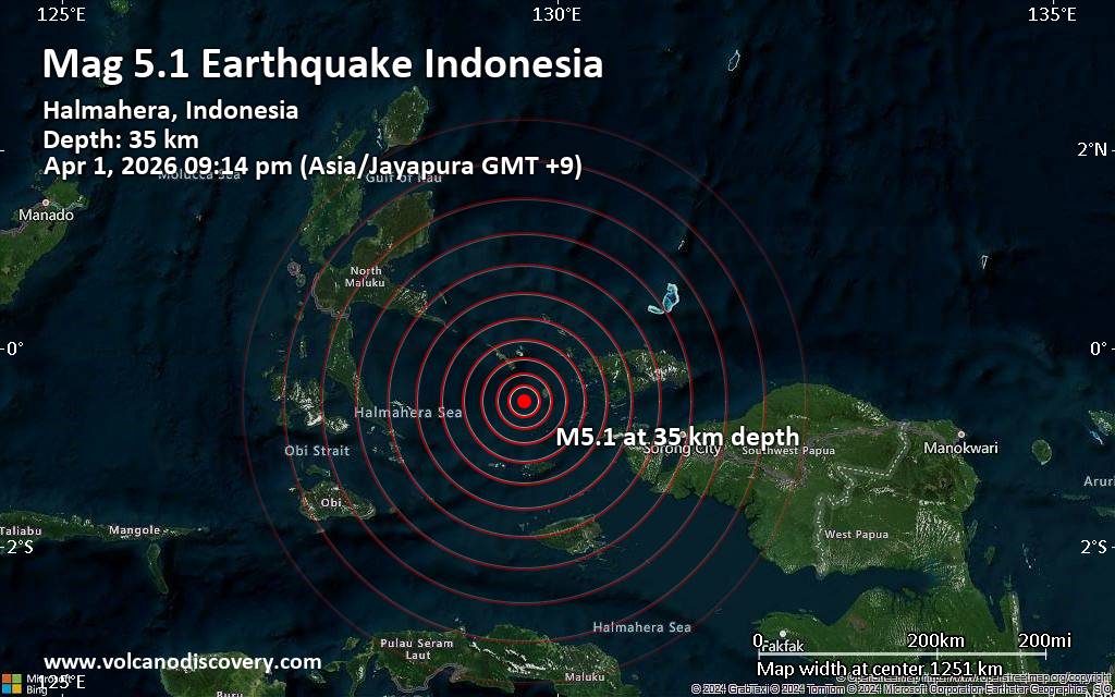 An earthquake of magnitude 5.1 occurred in the evening on Wednesday, April 1st, 2026, at 9:14 pm local time near Waisai, Raja Ampat Regency, Southwest Papua, Indonesia, as reported by the European-Mediterranean Seismological Centre (EMSC).
According to preliminary data, the quake was located at a moderately shallow depth of 35. km. The exact magnitude, epicenter, and depth of the quake might be revised within the next few hours or minutes as seismologists review data and refine their calculations, or as other agencies issue their report.
A second report was later issued by Indonesia's Meteorology, Climatology, and Geophysical Agency, which listed it as a magnitude 5.3 earthquake. Other agencies reporting the same quake include the German Research Centre for Geosciences (GFZ) at magnitude 5.1, and the citizen-seismograph network of RaspberryShake at magnitude 5.1.
Generally quakes of this magnitude are recorded by more than one agency and the results can vary, with subsequent reports that come in after the first one often showing more accuracy.
Based on the preliminary seismic data, the quake should not have caused any significant damage, but was probably felt by many people as light vibration in the area of the epicenter.
Weak shaking might have been felt in Waisai (pop. 22,500) located 99 km from the epicenter.
VolcanoDiscovery will automatically update magnitude and depth if these change and follow up if other significant news about the quake become available. If you’re in the area, please send us your experience through our reporting mechanism, either online or via our mobile app. This will help us provide more first-hand updates to anyone around the globe who wants to know more about this quake.
Earthquake data: Date & time: Apr 1, 2026 09:14 pm (Jayapura time) local time (1 Apr 2026 12:14 GMT)Magnitude: 5.1 Depth: 35.00 km Epicenter latitude / longitude: 0.54°S / 129.67°E  (Raja Ampat Regency, Provinsi Papua Barat, Indonesia) Primary data source: EMSChttps://www.volcanodiscovery.com/earthquake/news/299021/Significant-51-quake-hits-near-Waisai-Raja-Ampat-Regency-Southwest-Papua-Indonesia.html
0
2
Read More
|
World Earthquake Report for Wednesday, 1 April 2026
Webmaster
7 hours ago
World Earthquake Report for Wednesday, 1 April 2026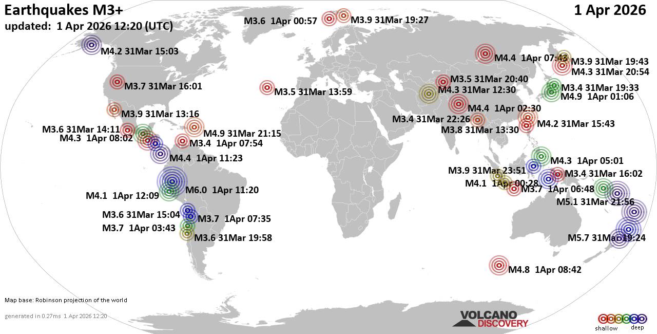 Worldwide earthquakes above magnitude 3 during the past 24 hours on 1 Apr 2026 Magnitude 6+: 1 earthquake Magnitude 5+: 3 earthquakes Magnitude 4+: 37 earthquakes Magnitude 3+: 154 earthquakes Magnitude 2+: 349 earthquakes No quakes of magnitude 7 or higher 10 largest earthquakes in the world (past 24 hours)Wednesday, Apr 1, 2026, at 06:20 am (Lima time) - Wednesday, Apr 1, 2026, at 08:24 am (GMT +13) - Tuesday, Mar 31, 2026, at 06:08 pm (GMT -12) - Wednesday, Apr 1, 2026, at 08:56 am (GMT +11) - Wednesday, Apr 1, 2026, at 10:06 am (GMT +9) - Tuesday, Mar 31, 2026, at 05:15 pm (GMT -4) - Wednesday, Apr 1, 2026, at 05:09 am (GMT +12) - Wednesday, Apr 1, 2026, at 04:42 pm (GMT +8) - Wednesday, Apr 1, 2026, at 08:17 pm (GMT +11) - Wednesday, Apr 1, 2026, at 05:54 pm (GMT +13) - Earthquakes reported feltWednesday, Apr 1, 2026, at 10:06 am (GMT +9) - Wednesday, Apr 1, 2026, at 06:20 am (Lima time) - Wednesday, Apr 1, 2026, at 02:02 am (GMT -6) - Tuesday, Mar 31, 2026, at 05:15 pm (GMT -4) - Tuesday, Mar 31, 2026, at 08:24 pm (GMT -4) - Wednesday, Apr 1, 2026, at 12:43 am (GMT -3) - Wednesday, Apr 1, 2026, at 08:24 am (GMT +13) - Tuesday, Mar 31, 2026, at 11:43 pm (Taipei time) - Tuesday, Mar 31, 2026, at 04:58 pm (GMT -3) - Wednesday, Apr 1, 2026, at 10:08 am (GMT -1) - Wednesday, Apr 1, 2026, at 01:13 am (GMT +3) - Wednesday, Apr 1, 2026, at 12:08 am (GMT +2) - Earthquake stats 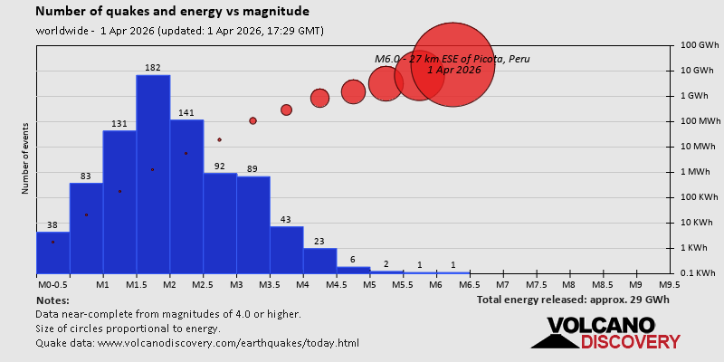 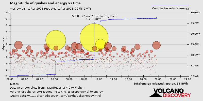 https://www.volcanodiscovery.com/earthquake/news/298995/World-Earthquake-Report-for-Wednesday-1-April-2026.html https://www.volcanodiscovery.com/earthquake/news/298995/World-Earthquake-Report-for-Wednesday-1-April-2026.html
0
2
Read More
|
|
Forums60
Topics767,365
Posts802,127
Members2,958
| |
Most Online17,963
Jan 15th, 2026
|
|
|
|
|
Copyright 1996 - 2026 by David Cottle. Designed by David Bate Jr. All Rights Reserved.
By using this forum, the user agrees not to transfer any data or technical information received under the agreement, to any other entity without the express approval of the AUS-CITY Forum Admins and/or authors of individual posts (Forum Admins and DoD/USSPACECOM for the analysis of satellite tracking data).
Two-line elements (TLE) and all other satellite data presented and distributed via this forum and e-mail lists of AUS-CITY are distributed with permission from DoD/USSTRATCOM.


Reprise Hosting

|

|


 - Click image for larger picture.")


