|
|
|
0 members (),
2,211
guests, and
25
robots. |
|
Key:
Admin,
Global Mod,
Mod
|
|
S |
M |
T |
W |
T |
F |
S |
|
1
|
2
|
3
|
4
|
5
|
6
|
7
|
|
8
|
9
|
10
|
11
|
12
|
13
|
14
|
|
15
|
16
|
17
|
18
|
19
|
20
|
21
|
|
22
|
23
|
24
|
25
|
26
|
27
|
28
|
|
There are no members with birthdays on this day. |
SPC MD 102
by Webmaster - Fri 20 Feb 2026 12:15:AM
|
SPC MD 103
by Webmaster - Fri 20 Feb 2026 12:15:AM
|
SPC MD 104
by Webmaster - Fri 20 Feb 2026 12:15:AM
|
|
|
|
|
|
|
|
|
|
|
|
|
|
|
 SPC MD 102
Webmaster
1 hour ago
SPC MD 102
Webmaster
1 hour ago
SPC MD 102MD 0102 CONCERNING TORNADO WATCH 10... FOR PORTIONS OF WESTERN/SOUTHERN INDIANA 
Mesoscale Discussion 0102
NWS Storm Prediction Center Norman OK
0526 PM CST Thu Feb 19 2026

Areas affected...Portions of western/southern Indiana

Concerning...Tornado Watch 10...

Valid 192326Z - 200100Z

The severe weather threat for Tornado Watch 10 continues.

SUMMARY...Tornado Watch #10 continues until 0200 UTC. A supercell
thunderstorm currently tracking across northern portions of the
watch in far western/southern Indiana is the primary focus for
severe activity in the short term, and has a history of rotation and
brief tornadoes.

DISCUSSION...The supercell thunderstorm tracking across the northern
portions of Tornado Watch #10 is the primary concern for severe
weather in the next 1-2 hours, with a history of rotation and
tornado production. While further north in the cooler air, VWP
profiles from KIND show strong curvature of the hodograph in the
lowest levels which will help support continued mesocyclone and
tornado development, with values in the 0-500m layer 120 m2/s2. Even
further south away from the frontal boundary, profiles from KLVX
still show strong support for low-topped supercell longevity.
However, some uncertainty exists in how far eastward current
convection will be maintained given only modest dewpoints in the
low-to-mid 50s F. In spite of this, the cooler temperatures aloft
and buoyancy evident in proximity sounding profiles, combined with
the strong kinematics discussed and history of tornado production,
the expectation is that severe convection should continue eastward
into central Indiana for at least the next two hours. This supercell
will continue to be capable of all hazards, including a strong
tornado.

..Halbert/Gleason.. 02/19/2026

...Please see www.spc.noaa.gov for graphic product...

ATTN...WFO...IND...

LAT...LON   38928700 38938715 38998724 39048731 39158730 39248725
            39348711 39398689 39438668 39478645 39498625 39518605
            39488595 39478587 39438578 39308570 39248569 39148570
            39068580 39018600 38978628 38958652 38948670 38928700

MOST PROBABLE PEAK TORNADO INTENSITY...120-150 MPH
MOST PROBABLE PEAK WIND GUST...55-70 MPH
MOST PROBABLE PEAK HAIL SIZE...1.50-2.50 IN
Read morehttps://www.spc.noaa.gov/products/md/md0102.html
0
1
Read More
|
SPC MD 103
Webmaster
1 hour ago
SPC MD 103MD 0103 CONCERNING TORNADO WATCH 10... FOR PORTIONS OF SOUTHERN ILLINOIS TO THE INDIANA BORDER 
Mesoscale Discussion 0103
NWS Storm Prediction Center Norman OK
0603 PM CST Thu Feb 19 2026

Areas affected...Portions of southern Illinois to the Indiana border

Concerning...Tornado Watch 10...

Valid 200003Z - 200130Z

The severe weather threat for Tornado Watch 10 continues.

SUMMARY...Tornado Watch #10 continues until 0200 UTC. A cluster of
supercellular thunderstorms in south-central Illinois is advancing
into the watch area, and will pose a threat for all hazards over the
next few hours.

DISCUSSION...As a cluster of supercell thunderstorms enters
west-northwestern potions of WW10 across south-central Illinois, the
threat for all hazards, including tornadoes, will persist over the
next few hours.

While VWPs from KLSX shows winds in the low levels beginning to veer
into more straight-line hodographs, the environment downstream of
the ongoing supercells (e.g. KILX, KVWX) still show strong curvature
of the hodograph in the low levels. Buoyancy remains relatively
modest, but when combined with observed kinematics, the environment
could continue to support mesocyclone development and maintenance as
storms continue to mature and enter the watch area. There is still
some uncertainty in this longevity given cooler temperatures and
lower dewpoints -- particularly where storms have already tracked
earlier this afternoon. Recent radar scans may indicate some
down-trending of convective activity is occurring (potentially due
to poor thermodynamics). Still, the environment does support a
continued severe threat, particularly with any long-lived/mature
supercell thunderstorms.

..Halbert/Gleason.. 02/20/2026

...Please see www.spc.noaa.gov for graphic product...

ATTN...WFO...IND...PAH...ILX...LSX...

LAT...LON   38448865 38598869 38758877 38818897 38928913 39028914
            39228907 39708862 39838821 39808764 39538731 39258723
            39038715 38858716 38678750 38568794 38458837 38448854
            38448865

MOST PROBABLE PEAK TORNADO INTENSITY...100-130 MPH
MOST PROBABLE PEAK WIND GUST...55-70 MPH
MOST PROBABLE PEAK HAIL SIZE...1.00-1.75 IN
Read morehttps://www.spc.noaa.gov/products/md/md0103.html
0
1
Read More
|
SPC MD 104
Webmaster
1 hour ago
SPC MD 104MD 0104 CONCERNING HEAVY SNOW FOR PORTIONS OF IOWA 
Mesoscale Discussion 0104
NWS Storm Prediction Center Norman OK
0607 PM CST Thu Feb 19 2026

Areas affected...Portions of Iowa

Concerning...Heavy snow

Valid 200007Z - 200600Z

SUMMARY...Snow rates possibly exceeding 1 inch per hour are expected
from western into central Iowa this evening.

DISCUSSION...Water-vapor imagery suggests significant midlevel
drying is spreading across southeast NE into southern IA, just south
of expected 700mb low track. Latest radar data supports this with a
well-developed corridor of heavy snow currently noted across eastern
NE into western IA. Large-scale ascent is beginning to increase
downstream into central IA, and precipitation is gradually expanding
into this region within the warm advection zone. Forecast soundings
exhibit steep midlevel lapse rates across  central IA, and
reflectively suggests some convective nature with this new
development that is spreading north. Over the next few hours a
southwest-northeast oriented band of heavy snow should establish
itself as the 700mb circulation advances east. Snow rates could
exceed 1 inch per hour at times.

..Darrow.. 02/20/2026

...Please see www.spc.noaa.gov for graphic product...

ATTN...WFO...DVN...ARX...DMX...FSD...OAX...

LAT...LON   41199564 41499378 42119201 43019227 42729386 42109584
            41199564
Read morehttps://www.spc.noaa.gov/products/md/md0104.html
0
1
Read More
|
SPC Tornado Watch 10 Status Reports
Webmaster
1 hour ago
SPC Tornado Watch 10 Status ReportsWW 0010 Status Updates 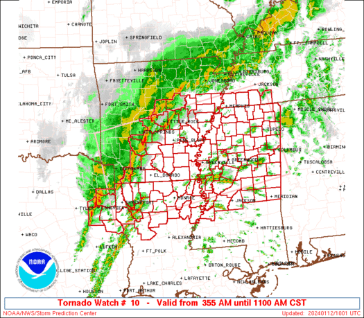
STATUS REPORT ON WW 3

SEVERE WEATHER THREAT CONTINUES RIGHT OF A LINE FROM 20 SE SEM TO
35 SSW ANB TO 20 SSE RMG.

FOR ADDITIONAL INFORMATION SEE MESOSCALE DISCUSSION 0020

..WEINMAN..01/10/26

ATTN...WFO...BMX...MOB...FFC...LIX...JAN...


STATUS REPORT FOR WT 3

SEVERE WEATHER THREAT CONTINUES FOR THE FOLLOWING AREAS

ALC005-011-017-025-027-051-081-085-087-101-109-111-113-123-129-
131-101640-

AL
.    ALABAMA COUNTIES INCLUDED ARE

BARBOUR              BULLOCK             CHAMBERS
CLARKE               CLAY                ELMORE
LEE                  LOWNDES             MACON
MONTGOMERY           PIKE                RANDOLPH
RUSSELL              TALLAPOOSA          WASHINGTON
WILCOX


GAC045-149-101640-

GA
.    GEORGIA COUNTIES INCLUDED ARE

CARROLL              HEARD


MSC041-111-101640-
Read morehttps://www.spc.noaa.gov/products/watch/ws0010.html
0
1
Read More
|
SPC Tornado Watch 10
Webmaster
1 hour ago
SPC Tornado Watch 10WW 10 TORNADO IL IN KY 191815Z - 200200Z
URGENT - IMMEDIATE BROADCAST REQUESTED
Tornado Watch Number 10
NWS Storm Prediction Center Norman OK
115 PM EST Thu Feb 19 2026

The NWS Storm Prediction Center has issued a

* Tornado Watch for portions of
  Southeast Illinois
  Southern Indiana
  Western and Central Kentucky

* Effective this Thursday afternoon and evening from 115 PM until
  900 PM EST.

* Primary threats include...
  A few tornadoes and a couple intense tornadoes possible
  Scattered large hail and isolated very large hail events to 2
    inches in diameter possible
  Scattered damaging wind gusts to 70 mph possible

SUMMARY...Thunderstorm development is anticipated this afternoon
from southeast Illinois into southern Indiana and western/central
Kentucky. In these areas, increasing low-level moisture will lead to
airmass destabilization. Strong vertical shear is in place,
supporting the potential for some of these storms to organize into
supercells. All severe hazards are possible with any supercells that
develop, including very large hail greater than 2" in diameter and
tornadoes. Low-level shear is strong enough to support the potential
for a strong (EF2+) tornado.

The tornado watch area is approximately along and 75 statute miles
north and south of a line from 50 miles west of Evansville IN to 50
miles east northeast of Louisville KY. For a complete depiction of
the watch see the associated watch outline update (WOUS64 KWNS
WOU0).

PRECAUTIONARY/PREPAREDNESS ACTIONS...

REMEMBER...A Tornado Watch means conditions are favorable for
tornadoes and severe thunderstorms in and close to the watch
area. Persons in these areas should be on the lookout for
threatening weather conditions and listen for later statements
and possible warnings.

&&

AVIATION...Tornadoes and a few severe thunderstorms with hail
surface and aloft to 2 inches. Extreme turbulence and surface wind
gusts to 60 knots. A few cumulonimbi with maximum tops to 500. Mean
storm motion vector 24035.

...Mosier
Read morehttps://www.spc.noaa.gov/products/watch/ww0010.html
0
1
Read More
|
SPC Day 3-8 Fire Weather Outlook
Webmaster
Yesterday at 09:59 PM
SPC Day 3-8 Fire Weather OutlookSPC Day 3-8 Fire Weather Outlook 
Day 3-8 Fire Weather Outlook
NWS Storm Prediction Center Norman OK
0354 PM CST Thu Feb 19 2026

Valid 211200Z - 271200Z

...Synopsis...
As upper-level troughing shifts eastward, a dry cold front sweeps
across the Southern Plains bringing dry northerly flow and fire
weather concerns to southern TX Day 3/Saturday. Widespread rainfall
across much of the Southeast should temporarily alleviate fire
weather concerns over the weekend. Rainfall should be limited
farther south across the Gulf Coast and FL, with particular concern
for FL where dry-post frontal northerly flow could increase the fire
weather threat for Day 4/Sunday and 5/Monday. The upper ridge will
begin to break down D6/Sunday, introducing dry return flow and
downslope winds across the Central and Southern Plains, potentially
increasing fire weather concerns through the extended period.

...Day 3/Saturday - Southern Texas...
Post frontal northerly winds behind a prominent dry cold front move
into TX Day 3/Saturday. Heightened fire weather concerns should
exist across portions of central and southern TX where RH will drop
to 10-20 percent with sustained northerly winds of 10-20 mph spread
across a dry fuelscape. 40% Critical probabilities have been
maintained.

...Day 4/Sunday and Day 5/Monday - Florida and Southern Plains...
Deep layer northwesterly flow develops across the Southeast and FL
behind a surface cold front underlying an amplifying upper-level
trough across the Northeast. Widespread wetting rainfall from Day
4/Sunday is expected to remain north of the Gulf Coast, with minimal
precipitation across FL. A cold front will pass through the northern
FL peninsula early afternoon D4/Sunday bringing post frontal
northwesterly winds and low RH. Coincident dry fuels should increase
the fire weather threat where 40% Critical probabilities have been
added. D5/Monday dry northwesterly flow is expected to shift to
southern FL where even lower RH is anticipated, maintaining 40%
Critical probabilities. There is uncertainty in the RH reductions
under a cooler, dry return flow pattern across the Southern Plains
on D5/Monday, which precludes introductions of Critical
probabilities at this time.

...Day 6/Tuesday - Southern and Central Plains...
Fire weather concerns reemerge across portions of the central and
southern High Plains via dry return flow and increasing westerly
winds aloft as the upper-level ridge across the Intermountain West
breaks down. 40% critical probabilities have been added where a
combination of low RH and strong westerly winds overlap dry fuels in
eastern NM, TX Panhandle, and southwestern OK. Beneath the
upper-level ridge a surface low will emerge in the lee of the
northern Rockies, tightening a surface pressure gradient across
eastern WY and western NE. Strong downslope winds may occur, though
cooler temperatures and RH uncertainties have limited the
introduction of Critical probabilities for now.

...Day 7/8 Wednesday/Thursday - West Texas...
40% probabilities have been introduced across the West TX region on
D7/Wednesday as long-range models are hinting at hot, dry, windy
conditions. Increasing northwest flow aloft and induced surface lee
troughing will support increased fire weather concerns. Uncertainty
is too high for D8/Thursday, though the anticipated pattern could
suggest an ongoing fire weather threat through the forecast period.

..Elizalde-Garcia/Williams.. 02/19/2026

...Please see www.spc.noaa.gov/fire for graphic product...
Read morehttps://www.spc.noaa.gov/products/exper/fire_wx/
0
1
Read More
|
World Earthquake Report for Thursday, 19 February 2026
Webmaster
Yesterday at 09:20 PM
World Earthquake Report for Thursday, 19 February 2026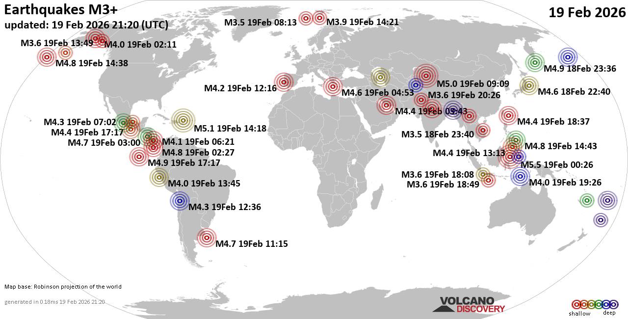 Worldwide earthquakes above magnitude 3 during the past 24 hours on 19 Feb 2026 Magnitude 5+: 3 earthquakes Magnitude 4+: 47 earthquakes Magnitude 3+: 116 earthquakes Magnitude 2+: 338 earthquakes No quakes of magnitude 6 or higher 10 largest earthquakes in the world (past 24 hours)Thursday, Feb 19, 2026, at 08:26 am (GMT +8) - Thursday, Feb 19, 2026, at 10:18 am (GMT -4) - Thursday, Feb 19, 2026, at 03:09 pm (Urumqi time) - Thursday, Feb 19, 2026, at 09:36 am (Ust-Nera time) - Thursday, Feb 19, 2026, at 11:17 am (GMT -6) - Thursday, Feb 19, 2026, at 04:02 pm (GMT +9) - Thursday, Feb 19, 2026, at 10:43 pm (Manila time) - Thursday, Feb 19, 2026, at 04:38 am (GMT -10) - Wednesday, Feb 18, 2026, at 09:27 pm (GMT -5) - Thursday, Feb 19, 2026, at 11:34 am (GMT -6) - Earthquakes reported feltThursday, Feb 19, 2026, at 12:13 pm (Universal Time) - Thursday, Feb 19, 2026, at 12:16 pm (Universal Time) - Wednesday, Feb 18, 2026, at 09:00 pm (Managua time) - Thursday, Feb 19, 2026, at 07:15 am (GMT -4) - Wednesday, Feb 18, 2026, at 11:38 pm (GMT +1) - Thursday, Feb 19, 2026, at 10:18 am (GMT -4) - Thursday, Feb 19, 2026, at 06:53 am (Athens time) - Thursday, Feb 19, 2026, at 10:43 pm (Manila time) - Thursday, Feb 19, 2026, at 03:09 pm (Urumqi time) - Thursday, Feb 19, 2026, at 07:28 pm (GMT +2) - Wednesday, Feb 18, 2026, at 08:15 pm (GMT -8) - Thursday, Feb 19, 2026, at 07:26 pm (GMT +2) - Thursday, Feb 19, 2026, at 06:48 am (GMT -6) - Thursday, Feb 19, 2026, at 08:34 pm (GMT +1) - #15: Mag 3.9 Costa Rica - 5 reportsThursday, Feb 19, 2026, at 01:21 pm (GMT -5) - Thursday, Feb 19, 2026, at 09:13 pm (GMT +8) - Thursday, Feb 19, 2026, at 12:35 am (GMT -5) - Thursday, Feb 19, 2026, at 04:21 pm (GMT +1) - Thursday, Feb 19, 2026, at 09:10 pm (GMT +2) - Thursday, Feb 19, 2026, at 05:24 pm (GMT +9) - Thursday, Feb 19, 2026, at 02:22 am (GMT -5) - Thursday, Feb 19, 2026, at 11:17 am (GMT +3) - Thursday, Feb 19, 2026, at 11:17 am (GMT -6) - Thursday, Feb 19, 2026, at 08:26 am (GMT +8) - Thursday, Feb 19, 2026, at 08:47 pm (GMT +2) - Wednesday, Feb 18, 2026, at 04:22 pm (GMT -9) - Wednesday, Feb 18, 2026, at 05:11 pm (GMT -9) - Thursday, Feb 19, 2026, at 07:40 am (GMT +9) - Earthquake stats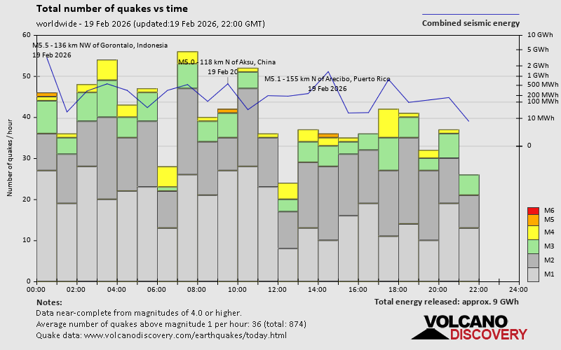 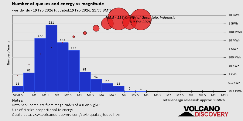 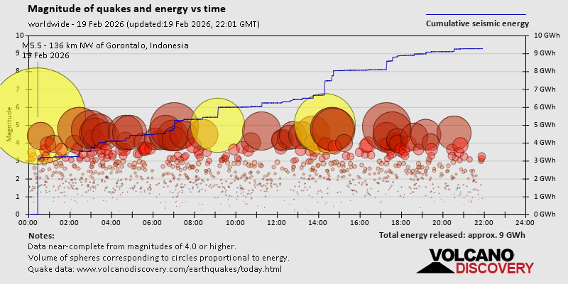 https://www.volcanodiscovery.com/earthquake/news/295281/World-Earthquake-Report-for-Thursday-19-February-2026.html https://www.volcanodiscovery.com/earthquake/news/295281/World-Earthquake-Report-for-Thursday-19-February-2026.html
0
15
Read More
|
Volcano earthquake report for Thursday, 19 Feb 2026
Webmaster
Yesterday at 08:50 PM
Volcano earthquake report for Thursday, 19 Feb 2026 World map showing volcanoes with shallow (less than 50 km) earthquakes within 20 km radius during the past 24 hours on 19 Feb 2026 Number in brackets indicate nr of quakes. Quakes detected near: Askja (2 quakes between mag 0.3-1.1), Bibinoi (1 quake mag 2.3), Churchill (1 quake mag 1.4), Clear Lake (23 quakes between mag 0.2-1.6), Coatepeque (1 quake mag 3.9), Coso (2 quakes between mag 0.8-1.0)
El Chichón (10 quakes between mag 1.1-2.6), Girekol (1 quake mag 1.3), Hrómundartindur (4 quakes between mag 0.0-1.2), Iwaki (1 quake mag 2.7), Katla (8 quakes between mag 0.0-2.8), Katmai (1 quake mag 1.0), Kirishima (1 quake mag 3.0), Kolumbo (1 quake mag 1.9), Laacher See (4 quakes between mag 0.5-1.0), Ljósufjöll (7 quakes between mag 0.4-1.3), Loihi (1 quake mag 1.7), Osorno (1 quake mag 3.0), Pacaya (1 quake mag 3.0), Paluweh (1 quake mag 3.0), Reventador (1 quake mag 1.6), San Miguel (1 quake mag 3.0), Semisopochnoi (1 quake mag 1.4), Tacana (1 quake mag 3.0), Tambora (1 quake mag 2.4), Taranaki (1 quake mag 2.6), Torfajökull (2 quakes between mag 1.3-2.0), White Island (1 quake mag 2.3) (updated 20h50)
Note: Earthquakes within 20 km from and at depths less than 50 km under active volcanoes are reported. The list is not complete because many volcanoes are not monitored and/or seismic data in high resolution is not available publicly.
Volcanoes with recent earthquakes above magnitude 2 or more than 10 quakes are listed below:
Bibinoi volcano (Halmahera): magnitude 2.3 earthquakeA magnitude 2.3 earthquake occurred at the volcano 17 hours ago. The quake, which might be volcanic in origin, was located at a depth of 3.00 km depth at 17 km distance WSW from the volcano. Earthquake details: 2.3 quake 22 km southeast of Labuha, Kabupaten Halmahera Selatan, North Maluku, Indonesia, Feb 19, 2026 01:16 pm (GMT +9) (17 km WSW) All earthquakes at BibinoiClear Lake volcano (California): 23 earthquakes up to magnitude 1.6Possible earthquake swarm: 23 earthquakes occurred near (under) the volcano during 24 hours, the last being recorded quake 14 minutes ago. Hypocenter depths ranged between 3.39 and 0.94 km. Earthquake details: (only 5 largest) 1.6 quake 12 mi southwest of Clearlake, Lake County, California, United States, Feb 18, 2026 02:02 pm (GMT -8) (17 km S) 1.5 quake 26 mi north of Santa Rosa, Sonoma County, California, United States, Feb 18, 2026 06:07 pm (GMT -8) (18 km S) 1.4 quake 26 mi north of Santa Rosa, Sonoma County, California, United States, Feb 19, 2026 02:50 am (GMT -8) (18 km SSW) 1.2 quake 28 mi north of Santa Rosa, Sonoma County, California, United States, Feb 19, 2026 06:56 am (GMT -8) (16 km SSW) 1.1 quake 25 mi north of Santa Rosa, Sonoma County, California, United States, Feb 19, 2026 08:15 am (GMT -8) (19 km S) All earthquakes at Clear LakeCoatepeque volcano (El Salvador): magnitude 3.9 earthquakeA magnitude 3.9 earthquake occurred at the volcano 13 hours ago. The quake, which might be volcanic in origin, was located at a depth of 3.00 km depth at 14 km distance E from the volcano. Earthquake details: 3.9 quake Departamento de La Libertad, 33 km northwest of San Salvador, El Salvador, Feb 19, 2026 01:58 am (GMT -6) (14 km E) All earthquakes at CoatepequeEl Chichón volcano (Southern Mexico): 10 earthquakes up to magnitude 2.610 earthquakes occurred near (under) the volcano during 13 hours, the last being recorded quake 10 hours ago. Hypocenter depths ranged between 3.00 and 2.40 km. Earthquake details: (only 5 largest) 2.6 quake Estado de Chiapas, 37 km southwest of Teapa, Estado de Tabasco, Mexico, Feb 18, 2026 03:37 pm (GMT -6) (1 km NNW) 2.5 quake Estado de Chiapas, 36 km southwest of Teapa, Estado de Tabasco, Mexico, Feb 18, 2026 09:45 pm (GMT -6) (1 km N) 2.3 quake Estado de Chiapas, 36 km southwest of Teapa, Estado de Tabasco, Mexico, Feb 18, 2026 09:59 pm (GMT -6) (1 km N) 2.2 quake Estado de Chiapas, 36 km southwest of Teapa, Estado de Tabasco, Mexico, Feb 19, 2026 04:20 am (GMT -6) (1 km N) 2.1 quake Estado de Chiapas, 37 km southwest of Teapa, Estado de Tabasco, Mexico, Feb 18, 2026 05:19 pm (GMT -6) (1 km NNW) All earthquakes at El ChichónIwaki volcano (Honshu): magnitude 2.7 earthquakeA magnitude 2.7 earthquake occurred at the volcano 24 hours ago. The quake, which might be volcanic in origin, was located at a depth of 11.10 km depth at 15 km distance E from the volcano. Earthquake details: 2.7 quake 7 km north of Hirosaki, Aomori, Japan, Feb 19, 2026 06:13 am (GMT +9) (15 km E) All earthquakes at IwakiKatla volcano (Iceland): 8 earthquakes up to magnitude 2.88 earthquakes occurred near (under) the volcano during 8 hours, the last being recorded quake 2 hours ago. Hypocenter depths ranged between 6.80 and 0.00 km. Earthquake details: (only 5 largest) 2.8 quake 58 km east of Vestmannaeyjar, South, Iceland, Feb 19, 2026 10:29 am (Reykjavik time) (6 km SW) 1.2 quake 5.0 km N of Hábunga Feb 19, 2026 06:31 pm (Universal Time) (3 km WSW) 1.2 quake Iceland: 4.8 km N of Hábunga Feb 19, 2026 10:46 am (Reykjavik time) (2 km WSW) 0.9 quake 3.9 km NNW of Hábunga Feb 19, 2026 10:30 am (Universal Time) (4 km WSW) 0.6 quake 3.4 km NNW of Hábunga Feb 19, 2026 10:28 am (Universal Time) (4 km SW) All earthquakes at KatlaKirishima volcano (Kyushu): magnitude 3.0 earthquakeA magnitude 3.0 earthquake occurred at the volcano 6 hours ago. The quake, which might be volcanic in origin, was located at a depth of 10.00 km depth at 6 km distance WNW from the volcano. Earthquake details: Reported seismic-like event (likely no quake): 35 km northwest of Miyakonojo, Miyazaki, Japan, Feb 19, 2026 11:37 pm (GMT +9) (6 km WNW) All earthquakes at KirishimaOsorno volcano (Southern Chile and Argentina): magnitude 3.0 earthquakeA magnitude 3.0 earthquake occurred at the volcano 5 hours ago. The quake, which might be volcanic in origin, was located at a depth of 10.00 km depth at 1 km distance SSW from the volcano. Earthquake details: Reported seismic-like event (likely no quake): 12 km north of Ensenada, Provincia de Llanquihue, Region de los Lagos, Chile, Feb 19, 2026 01:02 pm (GMT -3) (1 km SSW) All earthquakes at OsornoPacaya volcano (Guatemala): magnitude 3.0 earthquakeA magnitude 3.0 earthquake occurred at the volcano 15 hours ago. The quake, which might be volcanic in origin, was located at a depth of 10.00 km depth at 17 km distance N from the volcano. Earthquake details: Reported quake or seismic-like event: 15 km southwest of Guatemala City, Departamento de Guatemala, Guatemala, Feb 19, 2026 12:06 am (GMT -6) (17 km N) All earthquakes at PacayaPaluweh volcano (Lesser Sunda Islands): magnitude 3.0 earthquakeA magnitude 3.0 earthquake occurred at the volcano 20 hours ago. The quake, which might be volcanic in origin, was located at a depth of 4.00 km depth at 13 km distance W from the volcano. Earthquake details: 3.0 quake Flores Sea, 57 km north of Ende, Kabupaten Ende, East Nusa Tenggara, Indonesia, Feb 19, 2026 08:38 am (GMT +8) (13 km W) All earthquakes at PaluwehSan Miguel volcano (El Salvador): magnitude 3.0 earthquakeA magnitude 3.0 earthquake occurred at the volcano 16 hours ago. The quake, which might be volcanic in origin, was located at a depth of 10.00 km depth at 19 km distance S from the volcano. Earthquake details: Reported seismic-like event (likely no quake): 24 km south of San Miguel, Departamento de San Miguel, El Salvador, Feb 18, 2026 10:35 pm (GMT -6) (19 km S) All earthquakes at San MiguelTacana volcano (Southern Mexico): magnitude 3.0 earthquakeA magnitude 3.0 earthquake occurred at the volcano 24 minutes ago. The quake, which might be volcanic in origin, was located at a depth of 10.00 km depth at 19 km distance SSW from the volcano. Earthquake details: Unconfirmed quake or seismic-like event reported: 13 km northeast of Tapachula, Estado de Chiapas, Mexico, Feb 19, 2026 02:26 pm (GMT -6) (19 km SSW) All earthquakes at TacanaTambora volcano (Sumbawa): magnitude 2.4 earthquakeA magnitude 2.4 earthquake occurred at the volcano 21 hours ago. The quake, which might be volcanic in origin, was located at a depth of 13.00 km depth at 19 km distance NW from the volcano. Earthquake details: 2.4 quake Kabupaten Bima, 65 km northeast of Sumbawa Besar, Indonesia, Feb 19, 2026 07:40 am (GMT +8) (19 km NW) All earthquakes at TamboraTaranaki volcano (North Island): magnitude 2.6 earthquakeA magnitude 2.6 earthquake occurred at the volcano 7 hours ago. The quake, which might be volcanic in origin, was located at a depth of 10.70 km depth at 15 km distance NNE from the volcano. Earthquake details: 2.6 quake 15 km southeast of New Plymouth, Taranaki, New Zealand, Feb 20, 2026 02:44 am (GMT +13) (15 km NNE) All earthquakes at TaranakiUnnamed 24.00°N/121.83°E volcano (Taiwan): magnitude 3.9 earthquakeA magnitude 3.9 earthquake occurred at the volcano 7 hours ago. The quake, which might be volcanic in origin, was located at a depth of 34.50 km depth at 19 km distance SW from the volcano. Earthquake details: 3.9 quake Philippine Sea, 13 km southeast of Hualien City, Taiwan, Feb 19, 2026 10:09 pm (Taipei time) (19 km SW) All earthquakes at Unnamed 24.00°N/121.83°EWhite Island volcano (New Zealand): magnitude 2.3 earthquakeA magnitude 2.3 earthquake occurred at the volcano 6 hours ago. The quake, which might be volcanic in origin, was located at a depth of 5.00 km depth at 19 km distance SSE from the volcano. Earthquake details: 2.3 quake South Pacific Ocean, 37 km northeast of Whakatane, Bay of Plenty, New Zealand, Feb 20, 2026 03:29 am (GMT +13) (19 km SSE) All earthquakes at White Islandhttps://www.volcanodiscovery.com/earthquakes-volcanoes/news/295265/Volcano-earthquake-report-for-Thursday-19-Feb-2026.html
0
16
Read More
|
SPC Feb 19, 2026 2000 UTC Day 1 Convective Outlook
Webmaster
Yesterday at 08:02 PM
SPC Feb 19, 2026 2000 UTC Day 1 Convective OutlookSPC 2000Z Day 1 Outlook 
Day 1 Convective Outlook
NWS Storm Prediction Center Norman OK
0159 PM CST Thu Feb 19 2026

Valid 192000Z - 201200Z

...THERE IS AN ENHANCED RISK OF SEVERE THUNDERSTORMS ACROSS SOUTHERN
ILLINOIS AND SOUTHERN INDIANA...

...SUMMARY...
Severe thunderstorms including a few tornadoes, large hail and
damaging wind gusts are expected across parts of the Midwest and
lower Ohio Valley today.

...20Z Update...
No changes to the ongoing forecast appear to be needed at this time.
Dewpoints have had a tendency to mix into the upper 50s F this
afternoon in the lower Ohio Valley region. Convection has thus far
struggled to mature/intensify as a result. Areas of southern
Illinois into southwestern Indiana should be favored for more robust
storm initiation over the next few hours as the shortwave trough
moves in from the west. See the previous discussion for additional
details.

..Wendt.. 02/19/2026

.PREV DISCUSSION... /ISSUED 1022 AM CST Thu Feb 19 2026/

...Midwest/Ohio Valley...
Recent surface analysis places a low over eastern KS with a dryline
extending southwestward from this low through central OK and into
west TX. A warm front also extends eastward from this low across
central MO through central IL and central IN, separating the
moistening airmass south from the stable and cold airmass north.
Surface observations currently show mid 50s dewpoints through
southern IL and southern IN, with the 60s dewpoints farther south
into western KY. This surface low is forecast to progress
northeastward across central MO and into west-central IL today
before continuing northeastward into the southern Lake Michigan
vicinity by early tomorrow. Continued northward moisture advection
is anticipated as this low progresses, but this low-level moistening
will be countered somewhat by boundary-layer mixing, resulting in
some uncertainty to how high the dewpoints will reach across the OH
Valley this afternoon. General consensus places upper 50s dewpoints
into the I-70 corridor by the late afternoon.

These increasing dewpoints coupled with cold temperatures aloft and
afternoon temperatures in the upper 60s/low 70s should result in
modest airmass destabilization within the warm sector, despite a
relatively warm layer between 850-700 mb. In addition to improving
thermodynamics, the deep-layer southwesterly flow is forecast to
strengthen as well. The strongest mid-level flow will likely be
displaced just south of the better thermodynamics, but forecast
shear profiles are still quite robust across the OH Valley. The
general expectation is for this robust vertical shear (i.e.
effective bulk shear over 50 kt this afternoon) to somewhat
compensate for the more modest buoyancy, resulting in an organized
storm mode and supercells.

The dryline will likely remain west of this region during the
afternoon, with the lift over the warm sector provided by a subtle
lead shortwave currently moving through southern MO. This shortwave
should interact with the warm sector across the OH Valley this
afternoon, supporting thunderstorm development. Overall coverage is
not expected to be high, but any storms that do mature could produce
all severe hazards, including tornadoes. Additionally, the robust
shear suggests that once a storm matures, it could persist for
several hours. Given this updraft persistence in the presence of
veering low-level wind profiles, a strong (EF2+) tornado is
possible.

Additional thunderstorms are possible along the front during the
evening and overnight from the TN Valley eastward into the central
Appalachians. A few strong to severe storms are possible, but
limited buoyancy should keep this potential isolated. Greatest
probability for a severe storm along the front currently appears to
be across western/middle TN and southern-central KY this evening.
Read morehttps://www.spc.noaa.gov/products/outlook/day1otlk_2000.html
0
1
Read More
|
|
Forums60
Topics762,306
Posts797,036
Members2,957
| |
Most Online17,963
Jan 15th, 2026
|
|
|
|
|
Copyright 1996 - 2026 by David Cottle. Designed by David Bate Jr. All Rights Reserved.
By using this forum, the user agrees not to transfer any data or technical information received under the agreement, to any other entity without the express approval of the AUS-CITY Forum Admins and/or authors of individual posts (Forum Admins and DoD/USSPACECOM for the analysis of satellite tracking data).
Two-line elements (TLE) and all other satellite data presented and distributed via this forum and e-mail lists of AUS-CITY are distributed with permission from DoD/USSTRATCOM.


Reprise Hosting

|

|


 - Click image for larger picture.")


