|
|
|
0 members (),
1,372
guests, and
27
robots. |
|
Key:
Admin,
Global Mod,
Mod
|
|
S |
M |
T |
W |
T |
F |
S |
|
1
|
2
|
3
|
4
|
5
|
6
|
7
|
|
8
|
9
|
10
|
11
|
12
|
13
|
14
|
|
15
|
16
|
17
|
18
|
19
|
20
|
21
|
|
22
|
23
|
24
|
25
|
26
|
27
|
28
|
|
There are no members with birthdays on this day. |
 Volcano earthquake report for Wednesday, 25 Feb 2026
Webmaster
2 hours ago
Volcano earthquake report for Wednesday, 25 Feb 2026
Webmaster
2 hours ago
Volcano earthquake report for Wednesday, 25 Feb 2026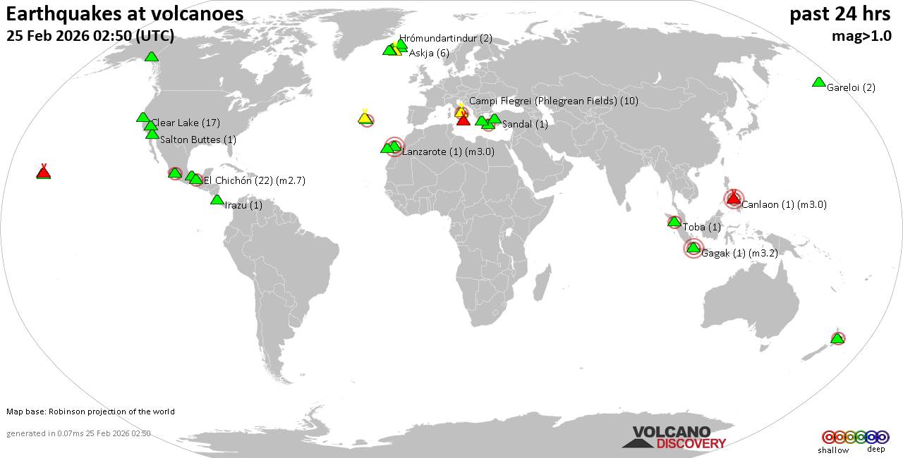 World map showing volcanoes with shallow (less than 50 km) earthquakes within 20 km radius during the past 24 hours on 25 Feb 2026 Number in brackets indicate nr of quakes. Quakes detected near: Askja (6 quakes between mag 0.0-1.4), Brennisteinsfjöll (2 quakes between mag 0.6-1.3), Campi Flegrei (Phlegrean Fields) (8 quakes between mag 0.1-2.1), Canlaon (1 quake mag 3.0), Churchill (1 quake mag 1.8), Clear Lake (18 quakes between mag 0.6-1.6)
Don Joao de Castro Bank (1 quake mag 2.8), El Chichón (8 quakes between mag 2.1-2.7), Etna (4 quakes between mag 0.9-3.5), Gagak (1 quake mag 3.2), Gareloi (2 quakes between mag 0.8-1.1), Hrómundartindur (3 quakes between mag 0.1-1.6), Irazu (1 quake mag 1.7), Katla (4 quakes between mag 0.5-1.3), Kilauea (2 quakes between mag 1.8-1.9), Kolumbo (1 quake mag 2.7), Krísuvík (2 quakes between mag 0.7-1.0), Lanzarote (1 quake mag 3.0), Loihi (3 quakes between mag 1.7-1.9), Maunaloa (1 quake mag 1.5), Michoacán-Guanajuato (1 quake mag 2.8), Prestahnukur (2 quakes between mag 1.1-1.5), Salton Buttes (1 quake mag 1.3), San Martín (1 quake mag 4.2), Sandal (1 quake mag 1.3), Sousaki (1 quake mag 1.0), Tenerife (2 quakes between mag 0.2-3.0), Terceira (1 quake mag 2.0), Tjörnes Fracture Zone (1 quake mag 1.4), Toba (1 quake mag 2.5) (updated 00h50)
Note: Earthquakes within 20 km from and at depths less than 50 km under active volcanoes are reported. The list is not complete because many volcanoes are not monitored and/or seismic data in high resolution is not available publicly.
Volcanoes with recent earthquakes above magnitude 2 or more than 10 quakes are listed below:
Campi Flegrei (Phlegrean Fields) volcano (Italy): 8 earthquakes up to magnitude 2.18 earthquakes occurred near (under) the volcano during 12 hours, the last being recorded quake 1 hour 57 minutes ago. Hypocenter depths ranged between 4.53 and 0.01 km. Earthquake details: (only 5 largest) 2.1 quake 12 km west of Naples, Napoli, Campania, Italy, Feb 24, 2026 11:39 pm (GMT +1) (7 km NW) 2.0 quake Tyrrhenian Sea, 19 km northeast of Isola d'Ischia Island, Italy, Feb 24, 2026 11:40 am (GMT +1) (3 km SW) 0.5 quake Tyrrhenian Sea, 19 km northeast of Isola d'Ischia Island, Italy, Feb 24, 2026 10:12 pm (GMT +1) (4 km SSW) 0.1 quake 2 km southeast of Pozzuoli, Napoli, Campania, Italy, Feb 24, 2026 11:49 pm (GMT +1) (2 km WNW) 0.1 quake 2.7 km northwest of Monterusciello, Napoli, Campania, Italy, Feb 24, 2026 11:52 pm (GMT +1) (9 km NW) All earthquakes at Campi Flegrei (Phlegrean Fields)Canlaon volcano (Central Philippines): magnitude 3.0 earthquakeA magnitude 3.0 earthquake occurred at the volcano 20 hours ago. The quake, which might be volcanic in origin, was located at a depth of 10.00 km depth at 18 km distance NW from the volcano. Earthquake details: Reported seismic-like event (likely no quake): 18 km south of Bacolod City, Philippines, Feb 24, 2026 12:33 pm (GMT +8) (18 km NW) All earthquakes at CanlaonClear Lake volcano (California): 18 earthquakes up to magnitude 1.6Possible earthquake swarm: 18 earthquakes occurred near (under) the volcano during 22 hours, the last being recorded quake 1 hour 41 minutes ago. Hypocenter depths ranged between 22.91 and 1.07 km. Earthquake details: (only 5 largest) 1.6 quake Sonoma County, 14 mi southwest of Clearlake, Lake County, California, United States, Feb 24, 2026 03:09 pm (GMT -8) (17 km S) 1.6 quake 12 mi southwest of Clearlake, Lake County, California, United States, Feb 24, 2026 10:47 am (GMT -8) (15 km S) 1.5 quake 27 mi north of Santa Rosa, Sonoma County, California, United States, Feb 24, 2026 01:59 pm (GMT -8) (18 km SSW) 1.5 quake Sonoma County, 13 mi southwest of Clearlake, Lake County, California, United States, Feb 23, 2026 05:15 pm (GMT -8) (16 km SSW) 1.3 quake Lake County, 27 mi north of Santa Rosa, Sonoma County, California, United States, Feb 23, 2026 08:09 pm (GMT -8) (16 km S) All earthquakes at Clear LakeDon Joao de Castro Bank volcano (Azores): magnitude 2.8 earthquakeA magnitude 2.8 earthquake occurred at the volcano 18 hours ago. The quake, which might be volcanic in origin, was located at a depth of 2.00 km depth at 16 km distance SE from the volcano. Earthquake details: 2.8 quake North Atlantic Ocean, 85 km northwest of Ponta Delgada, Azores, Portugal, Feb 24, 2026 06:10 am (GMT -1) (16 km SE) All earthquakes at Don Joao de Castro BankEl Chichón volcano (Southern Mexico): 8 earthquakes up to magnitude 2.78 earthquakes occurred near (under) the volcano during 7 hours, the last being recorded quake 15 hours ago. Hypocenter depths ranged between 3.00 and 1.50 km. Earthquake details: (only 5 largest) 2.7 quake Estado de Chiapas, 36 km southwest of Teapa, Estado de Tabasco, Mexico, Feb 24, 2026 02:19 am (GMT -6) (1 km N) 2.6 quake Estado de Chiapas, 37 km southwest of Teapa, Estado de Tabasco, Mexico, Feb 24, 2026 01:22 am (GMT -6) (1 km NNW) 2.6 quake Estado de Chiapas, 37 km southwest of Teapa, Estado de Tabasco, Mexico, Feb 24, 2026 02:46 am (GMT -6) (1 km S) 2.4 quake Estado de Chiapas, 36 km southwest of Teapa, Estado de Tabasco, Mexico, Feb 23, 2026 10:36 pm (GMT -6) (2 km N) 2.2 quake Estado de Chiapas, 38 km southwest of Teapa, Estado de Tabasco, Mexico, Feb 24, 2026 03:22 am (GMT -6) (1 km SW) All earthquakes at El ChichónEtna volcano (Italy): 4 earthquakes up to magnitude 3.54 earthquakes occurred near (under) the volcano during 10 hours, the last being recorded quake 9 hours ago. Hypocenter depths ranged between 10.00 and 0.75 km. Earthquake details: 3.5 quake Province of Messina, 23 km northwest of Giarre, Catania, Sicily, Italy, Feb 24, 2026 07:40 am (GMT +1) (19 km NNE) 1.7 quake 8.9 km northeast of Adrano, Catania, Sicily, Italy, Feb 24, 2026 01:35 pm (GMT +1) (10 km WSW) 1.1 quake 11 km west of Giarre, Catania, Sicily, Italy, Feb 24, 2026 12:12 pm (GMT +1) (6 km E) 0.9 quake 36 km north of Catania, Catania, Sicily, Italy, Feb 24, 2026 05:15 pm (GMT +1) (9 km NE) All earthquakes at EtnaGagak volcano (West Java): magnitude 3.2 earthquakeA magnitude 3.2 earthquake occurred at the volcano 22 hours ago. The quake, which might be volcanic in origin, was located at a depth of 5.00 km depth at 10 km distance W from the volcano. Earthquake details: 3.2 quake Bogor Regency, 25 km west of Cicurug, Kabupaten Sukabumi, Jawa Barat, Indonesia, Feb 24, 2026 10:08 am (GMT +7) (10 km W) All earthquakes at GagakKolumbo volcano (Greece): magnitude 2.7 earthquakeA magnitude 2.7 earthquake occurred at the volcano 16 hours ago. The quake, which might be volcanic in origin, was located at a depth of 13.70 km depth at 11 km distance E from the volcano. Earthquake details: 2.7 quake Aegean Sea, 20 km northeast of Santorini Island, Greece, Feb 24, 2026 11:16 am (GMT +2) (11 km E) All earthquakes at KolumboLanzarote volcano (Canary Islands): magnitude 3.0 earthquakeA magnitude 3.0 earthquake occurred at the volcano 20 hours ago. The quake, which might be volcanic in origin, was located at a depth of 10.00 km depth at 17 km distance SSW from the volcano. Earthquake details: Reported quake or seismic-like event: 28 km southwest of Arrecife, Las Palmas, Canary Islands, Spain, Feb 24, 2026 05:20 am (GMT +0) (17 km SSW) All earthquakes at LanzaroteMichoacán-Guanajuato volcano (Western & Central Mexico): magnitude 2.8 earthquakeA magnitude 2.8 earthquake occurred at the volcano 17 hours ago. The quake, which might be volcanic in origin, was located at a depth of 10.90 km depth at 9 km distance SW from the volcano. Earthquake details: 2.8 quake 27 km west of Uruapan, Estado de Michoacan de Ocampo, Mexico, Feb 24, 2026 01:56 am (GMT -6) (9 km SW) All earthquakes at Michoacán-GuanajuatoSan Martín volcano (Western & Central Mexico): magnitude 4.2 earthquakeA magnitude 4.2 earthquake occurred at the volcano 11 hours ago. The quake, which might be volcanic in origin, was located at a depth of 42.90 km depth at 5 km distance SSW from the volcano. Earthquake details: 4.2 quake 13 km southeast of Crucecita, Estado de Oaxaca, Mexico, Feb 24, 2026 07:46 am (GMT -6) (5 km SSW) All earthquakes at San MartínTenerife volcano (Canary Islands): 2 earthquakes up to magnitude 3.02 earthquakes occurred near (under) the volcano during 10 hours, the last being recorded quake 3 hours ago. Hypocenter depths ranged between 10.00 and 8.00 km. Earthquake details: Reported seismic-like event (likely no quake): 30 km west of Santa Cruz de Tenerife, Spain, Feb 24, 2026 11:36 am (GMT +0) (18 km NNE) 0.2 quake 15 km north of Arona, Santa Cruz de Tenerife, Canary Islands, Spain, Feb 24, 2026 09:36 pm (Universal Time) (6 km SSE) All earthquakes at TenerifeToba volcano (Sumatra): magnitude 2.5 earthquakeA magnitude 2.5 earthquake occurred at the volcano 9 hours ago. The quake, which might be volcanic in origin, was located at a depth of 4.00 km depth at 9 km distance WSW from the volcano. Earthquake details: 2.5 quake Kabupaten Humbang Hasundutan, 41 km northwest of Tarutung, Indonesia, Feb 24, 2026 10:21 pm (GMT +7) (9 km WSW) All earthquakes at Tobahttps://www.volcanodiscovery.com/earthquakes-volcanoes/news/295853/Volcano-earthquake-report-for-Wednesday-25-Feb-2026.html
0
2
Read More
|
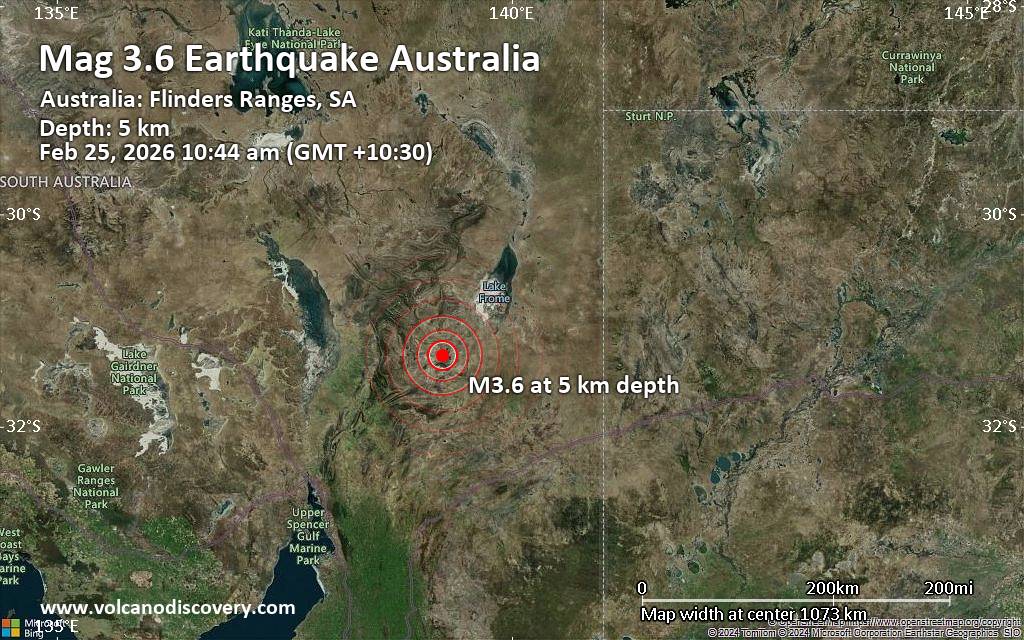
Magnitude 3.6 earthquake strikes near Blinman, South Australia, Australia
Webmaster
2 hours ago
Magnitude 3.6 earthquake strikes near Blinman, South Australia, AustraliaJust 12 minutes ago, a 3.6-magnitude earthquake struck near Blinman, South Australia, Australia. The tremor was recorded in the morning on Wednesday, February 25th, 2026, at 10:14 am local time, at a very shallow depth of 3.1 miles below the surface.
The event was filed by Geoscience Australia (GeoAu), the first seismological agency to report it.
Our monitoring service identified a second report from the European-Mediterranean Seismological Centre (EMSC) which listed the quake at magnitude 3.6 as well.
Towns or cities near the epicenter where the quake might have been felt as very weak shaking include Blinman (pop. 63) located 35 miles from the epicenter.
Earthquake data: Date & time: Feb 25, 2026 10:44 am (GMT +10:30) local time (25 Feb 2026 00:14 GMT)Magnitude: 3.6 Depth: 5.00 km Epicenter latitude / longitude: 31.34°S / 139.23°E  ( South Australia, Australia) Primary data source: GeoAuhttps://www.volcanodiscovery.com/earthquake/news/295849/Magnitude-36-earthquake-strikes-near-Blinman-South-Australia-Australia.html
0
Read More
|
World Earthquake Report for Tuesday, 24 February 2026
Webmaster
2 hours ago
World Earthquake Report for Tuesday, 24 February 2026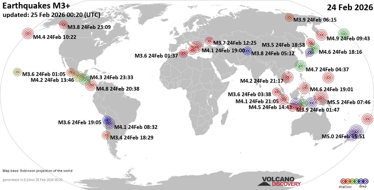 Worldwide earthquakes above magnitude 3 during the past 24 hours on 25 Feb 2026 Magnitude 5+: 2 earthquakes Magnitude 4+: 29 earthquakes Magnitude 3+: 139 earthquakes Magnitude 2+: 367 earthquakes No quakes of magnitude 6 or higher 10 largest earthquakes in the world (past 24 hours)Tuesday, Feb 24, 2026, at 04:46 pm (Jayapura time) - Wednesday, Feb 25, 2026, at 03:51 am (GMT +12) - Tuesday, Feb 24, 2026, at 09:43 pm (GMT +12) - Tuesday, Feb 24, 2026, at 08:03 pm (GMT +13) - Tuesday, Feb 24, 2026, at 03:38 pm (Panama time) - Tuesday, Feb 24, 2026, at 12:37 pm (Taipei time) - Tuesday, Feb 24, 2026, at 12:48 pm (GMT +10) - Wednesday, Feb 25, 2026, at 03:01 am (GMT +8) - Wednesday, Feb 25, 2026, at 03:16 am (GMT +9) - Wednesday, Feb 25, 2026, at 10:48 am (GMT +11) - Earthquakes reported feltTuesday, Feb 24, 2026, at 03:38 pm (Panama time) - Tuesday, Feb 24, 2026, at 08:00 pm (GMT +1) - Tuesday, Feb 24, 2026, at 05:42 am (GMT -8) - Tuesday, Feb 24, 2026, at 07:46 am (GMT -6) - Tuesday, Feb 24, 2026, at 07:07 pm (GMT +1) - Tuesday, Feb 24, 2026, at 12:37 pm (Taipei time) - Tuesday, Feb 24, 2026, at 02:37 am (GMT +1) - Tuesday, Feb 24, 2026, at 08:07 pm (GMT +1) - Tuesday, Feb 24, 2026, at 10:35 am (GMT +1) - Tuesday, Feb 24, 2026, at 02:21 am (GMT -8) - Tuesday, Feb 24, 2026, at 03:58 pm (GMT -5) - Tuesday, Feb 24, 2026, at 03:53 pm (GMT -5) - Tuesday, Feb 24, 2026, at 12:21 pm (GMT -3) - Tuesday, Feb 24, 2026, at 05:33 am (GMT +4) - Tuesday, Feb 24, 2026, at 05:13 pm (GMT +2) - Tuesday, Feb 24, 2026, at 05:46 pm (GMT +1) - Tuesday, Feb 24, 2026, at 11:39 pm (GMT +1) - Tuesday, Feb 24, 2026, at 02:45 pm (GMT -6) - Tuesday, Feb 24, 2026, at 02:25 am (GMT -10) - Tuesday, Feb 24, 2026, at 11:17 am (GMT +2) - Wednesday, Feb 25, 2026, at 01:23 am (GMT +8) - Tuesday, Feb 24, 2026, at 01:27 pm (GMT +9) - Tuesday, Feb 24, 2026, at 05:33 pm (GMT -6) - Tuesday, Feb 24, 2026, at 10:08 am (GMT +7) - Monday, Feb 23, 2026, at 08:17 pm (GMT -6) - Earthquake stats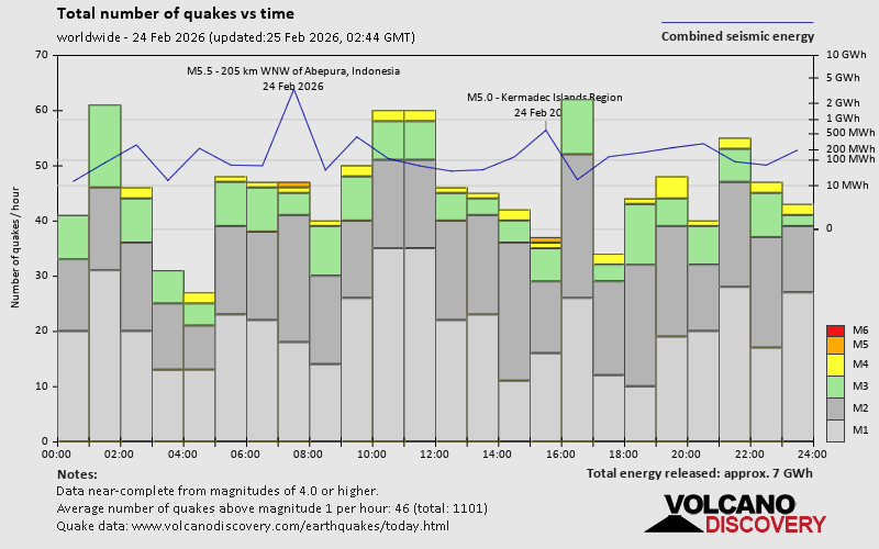 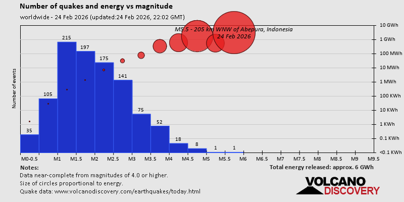 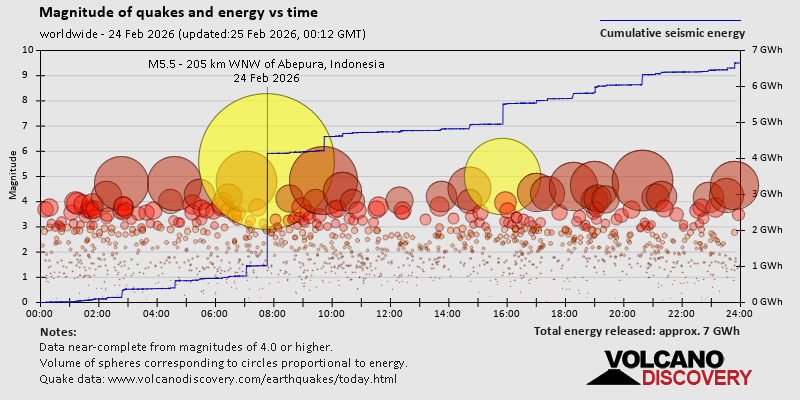 https://www.volcanodiscovery.com/earthquake/news/295766/World-Earthquake-Report-for-Tuesday-24-February-2026.html https://www.volcanodiscovery.com/earthquake/news/295766/World-Earthquake-Report-for-Tuesday-24-February-2026.html
0
Read More
|
Volcano earthquake report for Tuesday, 24 Feb 2026
Webmaster
Yesterday at 11:50 PM
Volcano earthquake report for Tuesday, 24 Feb 2026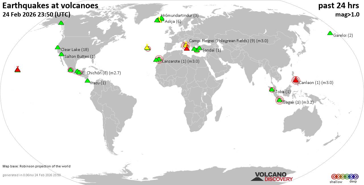 World map showing volcanoes with shallow (less than 50 km) earthquakes within 20 km radius during the past 24 hours on 24 Feb 2026 Number in brackets indicate nr of quakes. Quakes detected near: Askja (6 quakes between mag 0.0-1.4), Brennisteinsfjöll (2 quakes between mag 0.6-1.3), Campi Flegrei (Phlegrean Fields) (9 quakes between mag 0.1-3.0), Canlaon (1 quake mag 3.0), Churchill (1 quake mag 1.8), Clear Lake (18 quakes between mag 0.6-1.6)
Don Joao de Castro Bank (1 quake mag 2.8), El Chichón (8 quakes between mag 2.1-2.7), Etna (4 quakes between mag 0.9-3.5), Gagak (1 quake mag 3.2), Gareloi (2 quakes between mag 0.8-1.1), Hrómundartindur (3 quakes between mag 0.1-1.6), Irazu (1 quake mag 1.7), Katla (3 quakes between mag 0.5-1.3), Kilauea (2 quakes between mag 1.8-1.9), Kolumbo (1 quake mag 2.7), Krísuvík (2 quakes between mag 0.7-1.0), Lanzarote (1 quake mag 3.0), Loihi (2 quakes between mag 1.8-2.1), Maunaloa (1 quake mag 1.5), Michoacán-Guanajuato (1 quake mag 2.8), Prestahnukur (2 quakes between mag 1.1-1.5), Salton Buttes (1 quake mag 1.3), San Martín (1 quake mag 4.2), Sandal (1 quake mag 1.3), Sousaki (1 quake mag 1.0), Tenerife (2 quakes between mag 0.2-3.0), Terceira (1 quake mag 2.0), Tjörnes Fracture Zone (1 quake mag 1.4), Toba (1 quake mag 2.5) (updated 23h50)
Note: Earthquakes within 20 km from and at depths less than 50 km under active volcanoes are reported. The list is not complete because many volcanoes are not monitored and/or seismic data in high resolution is not available publicly.
Volcanoes with recent earthquakes above magnitude 2 or more than 10 quakes are listed below:
Campi Flegrei (Phlegrean Fields) volcano (Italy): 9 earthquakes up to magnitude 3.09 earthquakes occurred near (under) the volcano during 12 hours, the last being recorded quake 51 minutes ago. Hypocenter depths ranged between 10.00 and 0.01 km. Earthquake details: (only 5 largest) Unconfirmed quake or seismic-like event reported: 16 km west of Naples, Napoli, Campania, Italy, Feb 24, 2026 11:59 pm (GMT +1) (5 km W) 2.1 quake 12 km west of Naples, Napoli, Campania, Italy, Feb 24, 2026 11:39 pm (GMT +1) (7 km NW) 2.0 quake Tyrrhenian Sea, 19 km northeast of Isola d'Ischia Island, Italy, Feb 24, 2026 11:40 am (GMT +1) (3 km SW) 0.5 quake Tyrrhenian Sea, 19 km northeast of Isola d'Ischia Island, Italy, Feb 24, 2026 10:12 pm (GMT +1) (4 km SSW) 0.1 quake 2.7 km northwest of Monterusciello, Napoli, Campania, Italy, Feb 24, 2026 11:52 pm (GMT +1) (9 km NW) All earthquakes at Campi Flegrei (Phlegrean Fields)Canlaon volcano (Central Philippines): magnitude 3.0 earthquakeA magnitude 3.0 earthquake occurred at the volcano 19 hours ago. The quake, which might be volcanic in origin, was located at a depth of 10.00 km depth at 18 km distance NW from the volcano. Earthquake details: Reported seismic-like event (likely no quake): 18 km south of Bacolod City, Philippines, Feb 24, 2026 12:33 pm (GMT +8) (18 km NW) All earthquakes at CanlaonClear Lake volcano (California): 18 earthquakes up to magnitude 1.6Possible earthquake swarm: 18 earthquakes occurred near (under) the volcano during 22 hours, the last being recorded quake 41 minutes ago. Hypocenter depths ranged between 22.91 and 1.07 km. Earthquake details: (only 5 largest) 1.6 quake Sonoma County, 14 mi southwest of Clearlake, Lake County, California, United States, Feb 24, 2026 03:09 pm (GMT -8) (17 km S) 1.6 quake 12 mi southwest of Clearlake, Lake County, California, United States, Feb 24, 2026 10:47 am (GMT -8) (15 km S) 1.5 quake 27 mi north of Santa Rosa, Sonoma County, California, United States, Feb 24, 2026 01:59 pm (GMT -8) (18 km SSW) 1.5 quake Sonoma County, 13 mi southwest of Clearlake, Lake County, California, United States, Feb 23, 2026 05:15 pm (GMT -8) (16 km SSW) 1.3 quake Lake County, 27 mi north of Santa Rosa, Sonoma County, California, United States, Feb 23, 2026 08:09 pm (GMT -8) (16 km S) All earthquakes at Clear LakeDon Joao de Castro Bank volcano (Azores): magnitude 2.8 earthquakeA magnitude 2.8 earthquake occurred at the volcano 17 hours ago. The quake, which might be volcanic in origin, was located at a depth of 2.00 km depth at 16 km distance SE from the volcano. Earthquake details: 2.8 quake North Atlantic Ocean, 85 km northwest of Ponta Delgada, Azores, Portugal, Feb 24, 2026 06:10 am (GMT -1) (16 km SE) All earthquakes at Don Joao de Castro BankEl Chichón volcano (Southern Mexico): 8 earthquakes up to magnitude 2.78 earthquakes occurred near (under) the volcano during 7 hours, the last being recorded quake 14 hours ago. Hypocenter depths ranged between 3.00 and 1.50 km. Earthquake details: (only 5 largest) 2.7 quake Estado de Chiapas, 36 km southwest of Teapa, Estado de Tabasco, Mexico, Feb 24, 2026 02:19 am (GMT -6) (1 km N) 2.6 quake Estado de Chiapas, 37 km southwest of Teapa, Estado de Tabasco, Mexico, Feb 24, 2026 01:22 am (GMT -6) (1 km NNW) 2.6 quake Estado de Chiapas, 37 km southwest of Teapa, Estado de Tabasco, Mexico, Feb 24, 2026 02:46 am (GMT -6) (1 km S) 2.4 quake Estado de Chiapas, 36 km southwest of Teapa, Estado de Tabasco, Mexico, Feb 23, 2026 10:36 pm (GMT -6) (2 km N) 2.2 quake Estado de Chiapas, 38 km southwest of Teapa, Estado de Tabasco, Mexico, Feb 24, 2026 03:22 am (GMT -6) (1 km SW) All earthquakes at El ChichónEtna volcano (Italy): 4 earthquakes up to magnitude 3.54 earthquakes occurred near (under) the volcano during 10 hours, the last being recorded quake 8 hours ago. Hypocenter depths ranged between 10.00 and 0.75 km. Earthquake details: 3.5 quake Province of Messina, 23 km northwest of Giarre, Catania, Sicily, Italy, Feb 24, 2026 07:40 am (GMT +1) (19 km NNE) 1.7 quake 8.9 km northeast of Adrano, Catania, Sicily, Italy, Feb 24, 2026 01:35 pm (GMT +1) (10 km WSW) 1.1 quake 11 km west of Giarre, Catania, Sicily, Italy, Feb 24, 2026 12:12 pm (GMT +1) (6 km E) 0.9 quake 36 km north of Catania, Catania, Sicily, Italy, Feb 24, 2026 05:15 pm (GMT +1) (9 km NE) All earthquakes at EtnaGagak volcano (West Java): magnitude 3.2 earthquakeA magnitude 3.2 earthquake occurred at the volcano 21 hours ago. The quake, which might be volcanic in origin, was located at a depth of 5.00 km depth at 10 km distance W from the volcano. Earthquake details: 3.2 quake Bogor Regency, 25 km west of Cicurug, Kabupaten Sukabumi, Jawa Barat, Indonesia, Feb 24, 2026 10:08 am (GMT +7) (10 km W) All earthquakes at GagakKolumbo volcano (Greece): magnitude 2.7 earthquakeA magnitude 2.7 earthquake occurred at the volcano 15 hours ago. The quake, which might be volcanic in origin, was located at a depth of 13.70 km depth at 11 km distance E from the volcano. Earthquake details: 2.7 quake Aegean Sea, 20 km northeast of Santorini Island, Greece, Feb 24, 2026 11:16 am (GMT +2) (11 km E) All earthquakes at KolumboLanzarote volcano (Canary Islands): magnitude 3.0 earthquakeA magnitude 3.0 earthquake occurred at the volcano 19 hours ago. The quake, which might be volcanic in origin, was located at a depth of 10.00 km depth at 17 km distance SSW from the volcano. Earthquake details: Reported quake or seismic-like event: 28 km southwest of Arrecife, Las Palmas, Canary Islands, Spain, Feb 24, 2026 05:20 am (GMT +0) (17 km SSW) All earthquakes at LanzaroteLoihi volcano (Hawai'i (Big Island)): 2 earthquakes up to magnitude 2.12 earthquakes occurred near (under) the volcano during 8 hours, the last being recorded quake 5 hours ago. Hypocenter depths ranged between 32.55 and 31.75 km. Earthquake details: 2.1 quake North Pacific Ocean, 12 mi southeast of Pāhala, Hawaii County, Hawaii, United States, Feb 24, 2026 08:44 am (GMT -10) (19 km NW) 1.8 quake North Pacific Ocean, 39 mi southeast of of Hawai‘i Island, Hawaii County, Hawaii, United States, Feb 24, 2026 01:00 am (GMT -10) (18 km NW) All earthquakes at LoihiMichoacán-Guanajuato volcano (Western & Central Mexico): magnitude 2.8 earthquakeA magnitude 2.8 earthquake occurred at the volcano 16 hours ago. The quake, which might be volcanic in origin, was located at a depth of 10.90 km depth at 9 km distance SW from the volcano. Earthquake details: 2.8 quake 27 km west of Uruapan, Estado de Michoacan de Ocampo, Mexico, Feb 24, 2026 01:56 am (GMT -6) (9 km SW) All earthquakes at Michoacán-GuanajuatoSan Martín volcano (Western & Central Mexico): magnitude 4.2 earthquakeA magnitude 4.2 earthquake occurred at the volcano 10 hours ago. The quake, which might be volcanic in origin, was located at a depth of 42.90 km depth at 5 km distance SSW from the volcano. Earthquake details: 4.2 quake 13 km southeast of Crucecita, Estado de Oaxaca, Mexico, Feb 24, 2026 07:46 am (GMT -6) (5 km SSW) All earthquakes at San MartínTenerife volcano (Canary Islands): 2 earthquakes up to magnitude 3.02 earthquakes occurred near (under) the volcano during 10 hours, the last being recorded quake 2 hours ago. Hypocenter depths ranged between 10.00 and 8.00 km. Earthquake details: Reported seismic-like event (likely no quake): 30 km west of Santa Cruz de Tenerife, Spain, Feb 24, 2026 11:36 am (GMT +0) (18 km NNE) 0.2 quake 15 km north of Arona, Santa Cruz de Tenerife, Canary Islands, Spain, Feb 24, 2026 09:36 pm (Universal Time) (6 km SSE) All earthquakes at TenerifeToba volcano (Sumatra): magnitude 2.5 earthquakeA magnitude 2.5 earthquake occurred at the volcano 8 hours ago. The quake, which might be volcanic in origin, was located at a depth of 4.00 km depth at 9 km distance WSW from the volcano. Earthquake details: 2.5 quake Kabupaten Humbang Hasundutan, 41 km northwest of Tarutung, Indonesia, Feb 24, 2026 10:21 pm (GMT +7) (9 km WSW) All earthquakes at Tobahttps://www.volcanodiscovery.com/earthquakes-volcanoes/news/295761/Volcano-earthquake-report-for-Tuesday-24-Feb-2026.html
0
Read More
|
Moderate 4.9 quake hits near David, David District, Provincia de Chiriqui, Panama
Webmaster
Yesterday at 08:49 PM
Moderate 4.9 quake hits near David, David District, Provincia de Chiriqui, Panama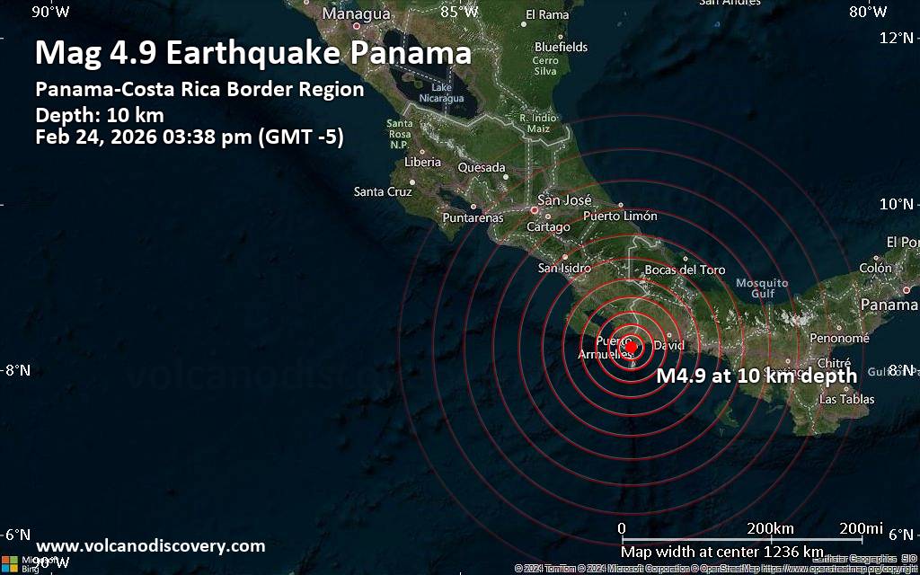 A magnitude 4.9 earthquake near David, David District, Provincia de Chiriqui, Panama, was reported only 10 minutes ago by the German Research Centre for Geosciences (GFZ), considered one of the key international agencies that monitor seismic activity worldwide. The earthquake occurred at a shallow depth of 10. km beneath the epicenter early afternoon on Tuesday, February 24th, 2026, at 3:38 pm local time. The exact magnitude, epicenter, and depth of the quake might be revised within the next few hours or minutes as seismologists review data and refine their calculations, or as other agencies issue their report.
Based on the preliminary seismic data, the quake was probably felt by many people in the area of the epicenter. It should not have caused significant damage, other than objects falling from shelves, broken windows, etc.
In Monte Verde (pop. 530) located 4 km from the epicenter, Puerto Armuelles (pop. 11,700) 5 km away, El Palmar (pop. 4,500) 7 km away, Manaca Civil (pop. 1,200) 11 km away, Manaca Norte (pop. 1,300) 13 km away, and Progreso (pop. 2,200) 20 km away, the quake should have been felt as light shaking.
Weak shaking might have been felt in La Concepcion (pop. 17,700) located 41 km from the epicenter, Pedregal (pop. 17,400) 54 km away, and David (pop. 82,000) 55 km away.
VolcanoDiscovery will automatically update magnitude and depth if these change and follow up if other significant news about the quake become available. If you’re in the area, please send us your experience through our reporting mechanism, either online or via our mobile app. This will help us provide more first-hand updates to anyone around the globe who wants to know more about this quake.
Earthquake data: Date & time: Feb 24, 2026 08:38 pm (Universal Time) local time (24 Feb 2026 20:38 GMT)Magnitude: 5.0 Depth: 18.00 km Epicenter latitude / longitude: 8.29°N / 82.85°W  ( Provincia de Chiriqui, Panama) Primary data source: EMSChttps://www.volcanodiscovery.com/earthquake/news/295837/Moderate-49-quake-hits-near-David-David-District-Provincia-de-Chiriqui-Panama.html
0
Read More
|
Seismic-like event, possible earthquake, reported few minutes ago near Volcan, Chiriquí Province, Panama
Webmaster
Yesterday at 08:41 PM
Seismic-like event, possible earthquake, reported few minutes ago near Volcan, Chiriquí Province, Panama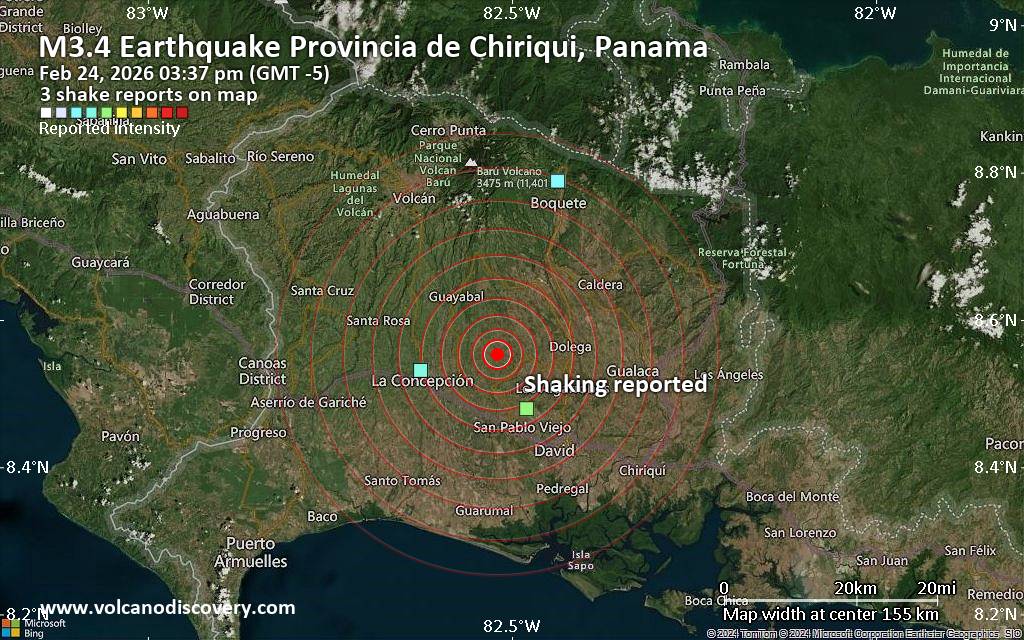 Unconfirmed quake or seismic-like event reported: 22 km east of Volcan, Provincia de Chiriqui, Panama, 4 minutes ago We are receiving unverified early reports of ground shaking possibly caused by seismic activity in or near Volcan, Chiriquí Province, Panama on 24 Feb 2026 (GMT) at approximately 20:37 GMT.
There are no details yet on the magnitude or depth of this possible quake. If confirmed, we can expect more accurate data to emerge in the next few minutes. The location, magnitude and time mentioned are indicative, based on our best-fit seismic model. They are temporary until our AllQuakes monitoring service receives more exact scientific data from a national or international seismological agency. Check back here shortly and stay safe.
Earthquake data: Date & time: Feb 24, 2026 03:37 pm (GMT -5) local time (24 Feb 2026 20:37 GMT)Magnitude: unspecified Depth: unspecified Epicenter latitude / longitude: 8.55°N / 82.52°W ( Provincia de Chiriqui, Panama) Primary data source: VolcanoDiscoveryhttps://www.volcanodiscovery.com/earthquake/news/295833/Seismic-like-event-possible-earthquake-reported-few-minutes-ago-near-Volcan-Chiriqui-Province-Panama.html
0
Read More
|
Moderate 4.2 quake hits near Lushnje, Bashkia Lushnje, Qarku i Fierit, Albania
Webmaster
Yesterday at 07:13 PM
Moderate 4.2 quake hits near Lushnje, Bashkia Lushnje, Qarku i Fierit, Albania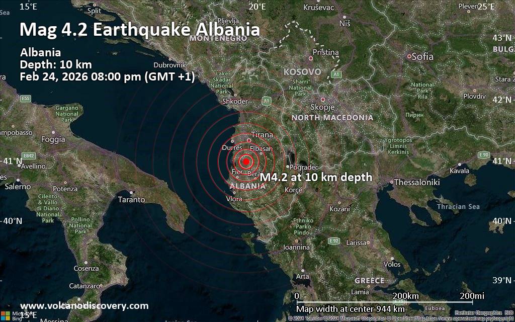 Just 12 minutes ago, a 4.2-magnitude earthquake struck near Lushnje, Bashkia Lushnje, Qarku i Fierit, Albania. The tremor was recorded in the evening on Tuesday, February 24th, 2026, at 8:00 pm local time, at a shallow depth of 10. km below the surface.
The event was filed by the European-Mediterranean Seismological Centre (EMSC), the first seismological agency to report it.
A second report was later issued by The Seismological Survey of Serbia (SSS), which listed it as a magnitude 4.2 earthquake as well. Other agencies reporting the same quake include the National Observatory of Athens (NOA) at magnitude 4.1, the German Research Centre for Geosciences (GFZ) at magnitude 4.2, The Seismological Laboratory of the University of Athens (UOA) at magnitude 4.1, the citizen-seismograph network of RaspberryShake at magnitude 4.2, and The Aristotle University of Thessaloniki Geophysical Lab. (AUTH) at magnitude 3.9.
Based on the preliminary seismic data, the quake was probably felt by many people in the area of the epicenter. It should not have caused significant damage, other than objects falling from shelves, broken windows, etc.
In Golem (pop. 7,000) located 6 km from the epicenter, Peqin (pop. 16,600) 6 km away, and Lushnje (pop. 63,100) 7 km away, the quake should have been felt as light shaking.
Weak shaking might have been felt in Kucove (pop. 31,100) located 25 km from the epicenter, Kavaje (pop. 30,000) 27 km away, Fier (pop. 56,300) 34 km away, Patos (pop. 16,000) 36 km away, Tirana (pop. 418,500) 38 km away, and Patos Fshat (pop. 22,700) 39 km away.
Other towns or cities near the epicenter where the quake might have been felt as very weak shaking include Durres (pop. 195,900) located 45 km from the epicenter.
Earthquake data: Date & time: Feb 24, 2026 07:00 pm (Universal Time) local time (24 Feb 2026 19:00 GMT)Magnitude: 4.2 Depth: 15.00 km Epicenter latitude / longitude: 40.99°N / 19.88°E  (Bashkia Lushnje, Qarku i Fierit, Albania) Primary data source: EMSChttps://www.volcanodiscovery.com/earthquake/news/295831/Moderate-42-quake-hits-near-Lushnje-Bashkia-Lushnje-Qarku-i-Fierit-Albania.html
0
Read More
|
Magnitude 4.7 earthquake strikes near Kalamansig, Sultan Kudarat, Soccsksargen, Philippines
Webmaster
Yesterday at 07:10 PM
Magnitude 4.7 earthquake strikes near Kalamansig, Sultan Kudarat, Soccsksargen, Philippines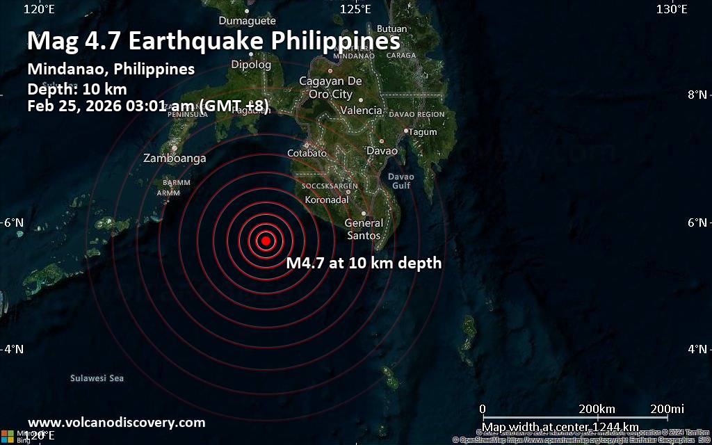 Indonesia's Meteorology, Climatology, and Geophysical Agency reported a magnitude 4.7 quake in the Philippines near Kalamansig, Sultan Kudarat, Soccsksargen, only 8 minutes ago. The earthquake hit early morning on Wednesday, February 25th, 2026, at 3:01 am local time at a shallow depth of 10. km. The exact magnitude, epicenter, and depth of the quake might be revised within the next few hours or minutes as seismologists review data and refine their calculations, or as other agencies issue their report.
A second report was later issued by the citizen-seismograph network of RaspberryShake, which listed it as a magnitude 4.7 earthquake as well.
Towns or cities near the epicenter where the quake might have been felt as very weak shaking include Palimbang (pop. 4,900) located 87 km from the epicenter, Sangay (pop. 3,800) 97 km away, Malisbeng (pop. 4,500) 97 km away, and Kalamansig (pop. 52,300) 107 km away.
VolcanoDiscovery will automatically update magnitude and depth if these change and follow up if other significant news about the quake become available. If you’re in the area, please send us your experience through our reporting mechanism, either online or via our mobile app. This will help us provide more first-hand updates to anyone around the globe who wants to know more about this quake.
Earthquake data: Date & time: Feb 25, 2026 03:01 am (GMT +8) local time (24 Feb 2026 19:01 GMT)Magnitude: 4.7 Depth: 10.00 km Epicenter latitude / longitude: 5.71°N / 123.58°E  ( Philippines) Primary data source: BMKGhttps://www.volcanodiscovery.com/earthquake/news/295829/Magnitude-47-earthquake-strikes-near-Kalamansig-Sultan-Kudarat-Soccsksargen-Philippines.html
0
Read More
|
World Earthquake Report for February 2026
Webmaster
Yesterday at 07:00 PM
World Earthquake Report for February 2026 Worldwide earthquakes above magnitude 5.5 during February 2026 Magnitude 9+: none Magnitude 8+: none Magnitude 7+: 1 earthquake Magnitude 6+: 11 earthquakes Magnitude 5+: 110 earthquakes Magnitude 4+: 984 earthquakes Magnitude 3+: 4175 earthquakes Magnitude 2+: 9278 earthquakes No quakes of magnitude 8 or higher List of 10 largest earthquakes in the world during February 2026:Saturday, Feb 14, 2026, at 01:27 pm (Efate time) - Tuesday, Feb 10, 2026, at 08:44 am (GMT -12) - Thursday, Feb 12, 2026, at 10:34 am (Santiago time) - Wednesday, Feb 4, 2026, at 11:39 pm (GMT +13) - Monday, Feb 16, 2026, at 02:58 am (GMT +11) - Saturday, Feb 7, 2026, at 06:20 am (Jayapura time) - Friday, Feb 6, 2026, at 01:06 am (GMT +7) - Tuesday, Feb 3, 2026, at 10:04 pm (Yangon time) - Sunday, Feb 8, 2026, at 03:42 pm (Mexico City time) - Sunday, Feb 8, 2026, at 01:23 pm (Santiago time) - Earthquake stats:   https://www.volcanodiscovery.com/view_news/293689/World-Earthquake-Report-for-February-2026.html https://www.volcanodiscovery.com/view_news/293689/World-Earthquake-Report-for-February-2026.html
0
Read More
|
Magnitude 5.1 earthquake strikes near Miyako, Miyako Shi, Iwate, Japan
Webmaster
Yesterday at 06:25 PM
Magnitude 5.1 earthquake strikes near Miyako, Miyako Shi, Iwate, Japan Just 7 minutes ago, a 5.1-magnitude earthquake struck near Miyako, Miyako Shi, Iwate, Japan. The tremor was recorded early morning on Wednesday, February 25th, 2026, at 3:16 am local time, at a moderately shallow depth of 53.50 km below the surface.
The event was filed by Japan's National Research Institute for Earth Science and Disaster Resilience (NIED), the first seismological agency to report it.
Based on the preliminary seismic data, the quake should not have caused any significant damage, but was probably felt by many people as light vibration in the area of the epicenter.
Weak shaking might have been felt in Yamada (pop. 15,200) located 12 km from the epicenter, Miyako (pop. 51,200) 13 km away, Kamaishi (pop. 43,100) 34 km away, Ofunato (pop. 35,500) 60 km away, Morioka (pop. 290,700) 78 km away, Hanamaki (pop. 94,700) 81 km away, Kitakami (pop. 93,000) 85 km away, and Oshu (pop. 112,900) 88 km away.
VolcanoDiscovery will automatically update magnitude and depth if these change and follow up if other significant news about the quake become available. If you’re in the area, please send us your experience through our reporting mechanism, either online or via our mobile app. This will help us provide more first-hand updates to anyone around the globe who wants to know more about this quake.
Earthquake data: Date & time: Feb 25, 2026 03:16 am (GMT +9) local time (24 Feb 2026 18:16 GMT)Magnitude: 5.1 Depth: 53.50 km Epicenter latitude / longitude: 39.56°N / 142.04°E  ( Miyako Shi, Iwate, Japan) Primary data source: NIEDhttps://www.volcanodiscovery.com/earthquake/news/295827/Magnitude-51-earthquake-strikes-near-Miyako-Miyako-Shi-Iwate-Japan.html
0
Read More
|
Thursday: Light Rain, Minimum Temperature: 9°C (49°F) Maximum Temperature: 12°C (54°F)
Webmaster
Yesterday at 05:00 PM
Maximum Temperature: 12°C (54°F), Minimum Temperature: 9°C (49°F), Wind Direction: south-westerly, Wind Speed: 11mph, Visibility: Good, Pressure: 1011mb, Humidity: 82%, UV Risk: 1, Pollution: Low, Sunrise: 07:05 GMT, Sunset: 17:40 GMT Source: Thursday: Light Rain, Minimum Temperature: 9°C (49°F) Maximum Temperature: 12°C (54°F)
0
25
Read More
|
Wednesday: Light Rain, Minimum Temperature: 10°C (49°F) Maximum Temperature: 14°C (58°F)
Webmaster
Yesterday at 05:00 PM
Maximum Temperature: 14°C (58°F), Minimum Temperature: 10°C (49°F), Wind Direction: southerly, Wind Speed: 9mph, Visibility: Good, Pressure: 1012mb, Humidity: 82%, UV Risk: 2, Pollution: Low, Sunrise: 07:07 GMT, Sunset: 17:38 GMT Source: Wednesday: Light Rain, Minimum Temperature: 10°C (49°F) Maximum Temperature: 14°C (58°F)
0
40
Read More
|
Magnitude 3.3 earthquake strikes near Lubin, Lubin County, Lower Silesian Voivodeship, Poland
Webmaster
Yesterday at 04:49 PM
Magnitude 3.3 earthquake strikes near Lubin, Lubin County, Lower Silesian Voivodeship, Poland A magnitude 3.3 earthquake near Lubin, Lubin County, Lower Silesian Voivodeship, Poland, was reported only 2 minutes ago by the European-Mediterranean Seismological Centre (EMSC), considered one of the key international agencies that monitor seismic activity worldwide. The earthquake occurred at a shallow depth of 10. km beneath the epicenter in the afternoon on Tuesday, February 24th, 2026, at 5:46 pm local time. The exact magnitude, epicenter, and depth of the quake might be revised within the next few hours or minutes as seismologists review data and refine their calculations, or as other agencies issue their report.
A second report was later issued by the German Research Centre for Geosciences (GFZ), which listed it as a magnitude 3.2 earthquake.
Based on the preliminary seismic data, the quake should not have caused any significant damage, but was probably felt by many people as light vibration in the area of the epicenter.
Weak shaking might have been felt in Lubin (pop. 77,500) located 5 km from the epicenter.
Other towns or cities near the epicenter where the quake might have been felt as very weak shaking include Polkowice (pop. 21,600) located 9 km from the epicenter, Legnica (pop. 106,000) 25 km away, Glogow (pop. 65,400) 26 km away, and Zlotoryja (pop. 15,600) 37 km away. In Jawor (pop. 23,900, 42 km away), Boleslawiec (pop. 40,700, 44 km away), Leszno (pop. 63,600, 55 km away), and Wroclaw (pop. 634,900, 72 km away), the quake was probably not felt.
Earthquake data: Date & time: Feb 24, 2026 04:46 pm (Universal Time) local time (24 Feb 2026 16:46 GMT)Magnitude: 3.3 Depth: 7.20 km Epicenter latitude / longitude: 51.46°N / 16.21°E  ( Lower Silesian Voivodeship, Poland) Primary data source: EMSChttps://www.volcanodiscovery.com/earthquake/news/295822/Magnitude-33-earthquake-strikes-near-Lubin-Lubin-County-Lower-Silesian-Voivodeship-Poland.html
0
Read More
|
Seismic-like event, possible earthquake, reported about 10 minutes ago near Salta, Salta, Argentina
Webmaster
Yesterday at 04:41 PM
Seismic-like event, possible earthquake, reported about 10 minutes ago near Salta, Salta, Argentina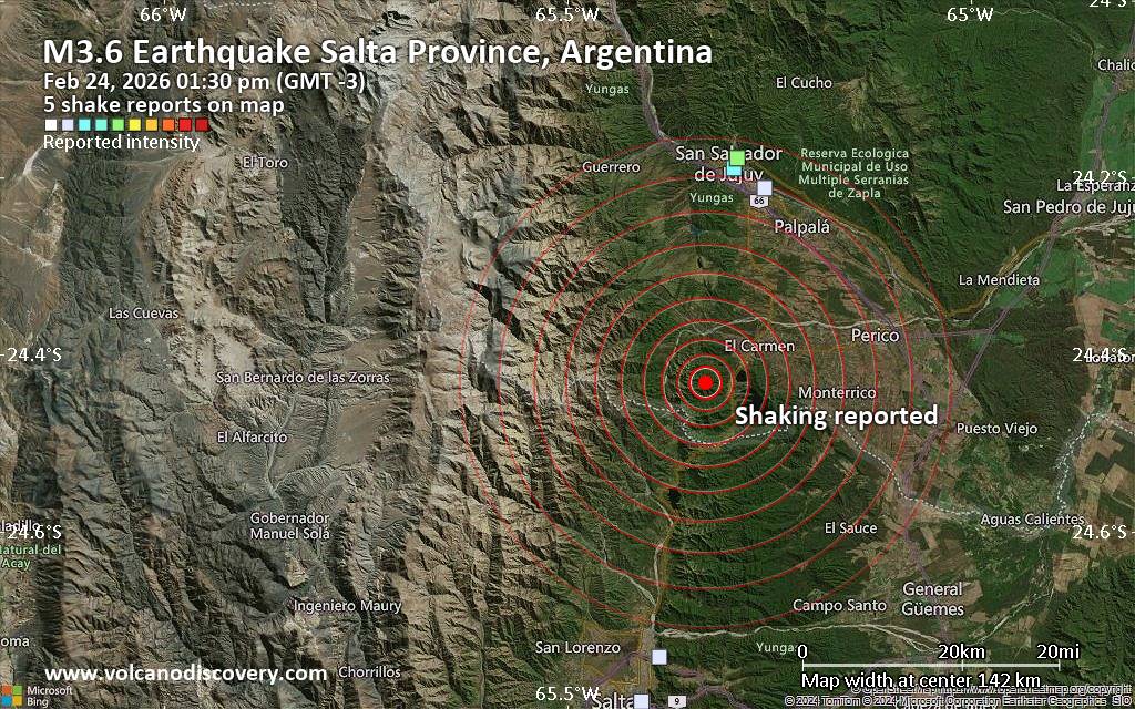 Unconfirmed quake or seismic-like event reported: 8 km northeast of Salta, Departamento Capital, Salta Province, Argentina, 11 minutes ago We are receiving unverified early reports of ground shaking possibly caused by seismic activity in or near Salta, Salta, Argentina on 24 Feb 2026 (GMT) at approximately 16:30 GMT.
There are no details yet on the magnitude or depth of this possible quake. If confirmed, we can expect more accurate data to emerge in the next few minutes. The location, magnitude and time mentioned are indicative, based on our best-fit seismic model. They are temporary until our AllQuakes monitoring service receives more exact scientific data from a national or international seismological agency. Check back here shortly and stay safe.
Earthquake data: Date & time: Feb 24, 2026 01:30 pm (GMT -3) local time (24 Feb 2026 16:30 GMT)Magnitude: unspecified Depth: unspecified Epicenter latitude / longitude: 24.43°S / 65.33°W  ( Salta Province, Argentina) Primary data source: VolcanoDiscoveryhttps://www.volcanodiscovery.com/earthquake/news/295820/Seismic-like-event-possible-earthquake-reported-about-10-minutes-ago-near-Salta-Salta-Argentina.html
0
Read More
|
|
Forums60
Topics763,219
Posts797,955
Members2,958
| |
Most Online17,963
Jan 15th, 2026
|
|
|
|
|
Copyright 1996 - 2026 by David Cottle. Designed by David Bate Jr. All Rights Reserved.
By using this forum, the user agrees not to transfer any data or technical information received under the agreement, to any other entity without the express approval of the AUS-CITY Forum Admins and/or authors of individual posts (Forum Admins and DoD/USSPACECOM for the analysis of satellite tracking data).
Two-line elements (TLE) and all other satellite data presented and distributed via this forum and e-mail lists of AUS-CITY are distributed with permission from DoD/USSTRATCOM.


Reprise Hosting

|

|


 - Click image for larger picture.")


