|
0 members (),
2,180
guests, and
51
robots. |
|
Key:
Admin,
Global Mod,
Mod
|
|
S |
M |
T |
W |
T |
F |
S |
|
|
|
|
|
|
|
1
|
|
2
|
3
|
4
|
5
|
6
|
7
|
8
|
|
9
|
10
|
11
|
12
|
13
|
14
|
15
|
|
16
|
17
|
18
|
19
|
20
|
21
|
22
|
|
23
|
24
|
25
|
26
|
27
|
28
|
29
|
|
30
|
31
|
|
|
|
|
|
|
There are no members with birthdays on this day. |
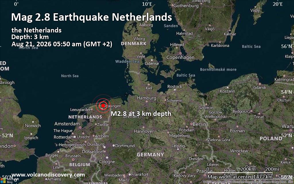
Small tremor of magnitude 2.8 just reported 20 km northeast of Groningen, Netherlands
|
 SPC Aug 21, 2026 Day 4-8 Severe Weather Outlook
Webmaster
2 hours ago
SPC Aug 21, 2026 Day 4-8 Severe Weather Outlook
Webmaster
2 hours ago
SPC Aug 21, 2026 Day 4-8 Severe Weather OutlookDay 4-8 Outlook 
Day 4-8 Convective Outlook
NWS Storm Prediction Center Norman OK
0354 AM CDT Fri Aug 21 2026

Valid 241200Z - 291200Z

...DISCUSSION...
A mid-level trough will move across the Northeast on Monday and the
surface front will be mostly offshore, reducing the severe weather
threat. As this trough departs, ridging will build across the
Rockies. This will eventually set up a pattern featuring individual
mid-level shortwave troughs within northwesterly flow from the
northern Plains to the Midwest. Some severe weather will likely
occur with mid-level shortwave troughs within this flow, but these
details likely will not become more clear until the short term.

Model consensus indicates a stronger mid-level shortwave trough
traversing the Pacific Northwest on D7/Thursday. This pattern would
be favorable for some severe weather threat across Montana, but at
this time, it appears moisture will stay farther east. Therefore, no
severe weather is anticipated.
Read morehttps://www.spc.noaa.gov/products/exper/day4-8/
0
10
Read More
|
SPC Aug 21, 2026 0730 UTC Day 3 Severe Thunderstorm Outlook
Webmaster
3 hours ago
SPC Aug 21, 2026 0730 UTC Day 3 Severe Thunderstorm OutlookSPC 0730Z Day 3 Outlook 
Day 3 Convective Outlook
NWS Storm Prediction Center Norman OK
0231 AM CDT Fri Aug 21 2026

Valid 231200Z - 241200Z

...THERE IS A MARGINAL RISK OF SEVERE THUNDERSTORMS ACROSS SOUTHWEST
TO CENTRAL MONTANA AND ACROSS PARTS OF THE NORTHEAST...

...SUMMARY...
Strong to severe thunderstorms capable of large hail and wind gusts
are possible in portions of the Northeast and across parts of
southwest and central Montana.

...Southwest into central Montana...
A mid-level shortwave trough will move across the Pacific Northwest
and into eastern British Columbia. While the parent trough is
forecast to deamplify through the period, moderate mid-level flow is
forecast to remain across much of Montana. Weak to potentially
moderate instability is forecast to develop across southwest into
central Montana. The moderate mid-level flow should provide ample
shear for storm organization including some supercell potential.
Strong heating will support steep low-level lapse rates and some
severe wind gust threat with the strongest storms.

...Portions of the Northeast...
A mid-level trough will become negatively tilted as it pivots from
the Great Lakes to the Northeast on Sunday. A broad 1006-1010mb
surface low is forecast somewhere in the vicinity of western New
York, southeast Ontario and southern Quebec. Storms are forecast by
mid-day along a cold front that should extend from New York into
central Pennsylvania on Sunday morning and move eastward through the
day. The environment ahead of this front is forecast to have
moderate to strong shear and relatively weak instability. Forecast
soundings show a lower storm top environment due to warmer
temperatures aloft. However, despite the weak instability, the
expectation for at least some supercell threat, combined with decent
instability within the hail growth zone and strong shear may support
some large hail and damaging wind gusts Sunday afternoon/evening.

..Bentley.. 08/21/2026
Read morehttps://www.spc.noaa.gov/products/outlook/day3otlk_0730.html
0
9
Read More
|
SPC Day 2 Fire Weather Outlook
Webmaster
3 hours ago
SPC Day 2 Fire Weather OutlookSPC Day 2 Fire Weather Outlook 
Day 2 Fire Weather Outlook
NWS Storm Prediction Center Norman OK
0201 AM CDT Fri Aug 21 2026

Valid 221200Z - 231200Z

...CRITICAL FIRE WEATHER AREA FOR PARTS OF NORTHEAST
CALIFORNIA...NORTHWEST NEVADA...AND SOUTH-CENTRAL/SOUTHEAST
OREGON...

...Synopsis...
A robust midlevel trough and accompanying south-southwesterly jet
max will overspread the Northwest through the period -- along the
northwestern periphery of an upper ridge centered on the Rockies. In
the low-levels, a cold front will move eastward across parts of WA
and OR during the day.

...Northern/Central Intermountain West...
Beneath the midlevel jet streak, enhanced deep-layer
south-southwesterly flow will overspread a dry antecedent air mass
across parts of the northern and central Intermountain West. This
will result in a broad area of 15-20 mph sustained
west-southwesterly surface winds and 15-20 percent RH during the
afternoon. Given receptive fuels across the region, elevated
fire-weather conditions are expected. Over parts of northeast CA,
northwest NV, and south-central/southeast OR, the overlap of 20-25
mph sustained southwesterly surface winds and around 15 percent RH
will favor critical fire-weather conditions. Locally critical
conditions will also be possible within the Cascade gaps, though
these conditions appear too localized for an additional Critical
area at this time.

...Dry Thunderstorms...
Robust midlevel height falls/forcing for ascent accompanying the
midlevel trough will overspread the northern Intermountain West into
the northern Rockies during the day. Here, deep boundary-layer
mixing beneath a midlevel moisture plume will yield sufficient
buoyancy for isolated to widely scattered high-based thunderstorms
regionally. While 0.7-1 inch PW will support a mix of wet and dry
storms, quick storm motions and the deep/dry boundary layer should
tend to limit overall rainfall. Therefore, isolated
lightning-induced ignitions will be possible atop increasingly
dry/receptive fuels. Additionally, the stronger storms will be
capable of producing strong to severe outflow winds (especially
toward the northern Rockies). For details on the severe risk, see
the SPC Day 2 Convective Outlook.

..Weinman.. 08/21/2026

...Please see www.spc.noaa.gov/fire for graphic product...
Read morehttps://www.spc.noaa.gov/products/fire_wx/fwdy2.html
0
8
Read More
|
SPC Day 1 Fire Weather Outlook
Webmaster
4 hours ago
SPC Day 1 Fire Weather OutlookSPC Day 1 Fire Weather Outlook 
Day 1 Fire Weather Outlook
NWS Storm Prediction Center Norman OK
0158 AM CDT Fri Aug 21 2026

Valid 211200Z - 221200Z

...Synopsis...
Along the northwestern periphery of an expansive upper ridge over
the West, a midlevel low will track slowly northeastward off the
Pacific Northwest coast. Accompanying this feature, a belt of
enhanced deep-layer south-southwesterly flow will overspread parts
of the central and northern Great Basin. Deep boundary-layer mixing
amid this enhanced flow aloft will yield 15-20 percent RH and around
15 mph sustained south-southwesterly surface winds across parts of
northeast CA, northwest NV, and southern OR. These dry/breezy
conditions atop dry fuels will result in elevated fire-weather
conditions during the afternoon.

Farther north, midlevel height falls/forcing for ascent preceding
the midlevel low will gradually overspread parts of the Pacific
Northwest late in the forecast period (generally after 06Z). Ample
midlevel moisture and steepening midlevel lapse rates will
contribute to sufficient instability for isolated thunderstorm
development during this time frame, and given receptive fuels,
lightning-induced ignitions will be a concern. Isolated high-based
thunderstorms will also be possible along the Cascades in OR during
the afternoon, though limited large-scale forcing for ascent casts
uncertainty on overall storm coverage compared to areas farther
north late in the period.

..Weinman.. 08/21/2026

...Please see www.spc.noaa.gov/fire for graphic product...
Read morehttps://www.spc.noaa.gov/products/fire_wx/fwdy1.html
0
8
Read More
|
SPC Aug 21, 2026 0600 UTC Day 1 Convective Outlook
Webmaster
4 hours ago
SPC Aug 21, 2026 0600 UTC Day 1 Convective OutlookSPC 1200Z Day 1 Outlook 
Day 1 Convective Outlook CORR 1
NWS Storm Prediction Center Norman OK
0146 AM CDT Fri Aug 21 2026

Valid 211200Z - 221200Z

...THERE IS A SLIGHT RISK OF SEVERE THUNDERSTORMS OVER PORTIONS OF
THE CENTRAL PLAINS...THE MIDWEST AND THE CAROLINAS...

CORRECTED FOR TEXT

...SUMMARY...
Scattered damaging hail (some greater than 2 inch diameter) and
severe wind gusts may occur over parts of the central Plains this
afternoon and evening. Scattered storms, some with severe wind gusts
and hail, also are possible across parts of the Midwest. Scattered
to numerous storms with damaging wind gusts are possible over the
Carolinas and Southeast.

...Central Plains...
Mid-level ridging over the western US is forecast to intensify,
strengthening northwesterly flow aloft over much of the central US.
Several embedded disturbances will pass overhead with the enhanced
northwesterlies through the day. A surface low will move
southeastward through the Great Lakes as a weak trailing cold front
moves southward through the central Plains and Midwest.

Ahead of the front, a plume of steep mid-level lapse rates will
shift eastward across the central Plains toward the Mid-MO Valley
atop a corridor of rich low-level moisture. Diurnal destabilization
should result in 3000-4000 J/kg of MLCAPE from SD to NE. Isolated to
widely scattered thunderstorm development is expected from the Black
Hills southeastward along the cold front. Elongated/straight
hodographs and 45+ kt effective shear will favor initial supercells.
Large to very large hail (some greater than 2 inches diameter) will
be possible. With time, a forward propagating cluster or two may
develop and move southeast across parts of NE and KS with the
potential for severe gusts (a few near 70-80 mph). It is unclear
exactly how far southeast any storms will persist overnight, but any
more substantial clustering could allow at least an isolated severe
threat to continue into early Saturday.

A much drier and hotter environment over the High Plains to the west
could also support isolated to widely scattered high-based storms
from eastern CO into western KS. Very steep lapse rates in the
lowest 2-3 km with modest buoyancy aloft could allow a few severe
gusts.

...Midwest...
Beneath the upper trough over the western Great Lakes, cool
mid-level temperatures and robust surface moisture should result in
moderate destabilization from WI into eastern IA and northwest IL.
Scattered thunderstorms by mid afternoon ahead of the cold front
spreading southeastward. Enhanced northwesterly flow with deep-layer
shear of 30-40 kt will promote a mix of organized clusters and
supercells. The large buoyancy will support a risk for damaging
gusts and some hail.

...Southeast and Gulf Coast...
A broad upper trough will move across the central US into parts of
the southern Appalachians while a weak cold front moves southward
from the mid Atlantic today and tonight. Weak ascent from the upper
trough and near the front should focus diurnal thunderstorm activity
across the Carolinas and southern Appalachians. Warm surface
temperatures and plentiful boundary-layer moisture will support
large buoyancy (3000+ J/kg MLCAPE) through the afternoon and evening
despite modest mid-level lapse rates. With scattered to numerous
storms expected, a few organized clusters may emerge with a risk
primarily for damaging wind gusts. Slight enhancement of the
westerly flow aloft could also support some isolated hail with the
stronger updrafts.

Farther south and west, a very humid and warm air mass is forecast
to become strongly unstable by early afternoon across the lower MS
Valley and Gulf Coast. Scattered to numerous thunderstorms are
expected along prior outflows and a weak, southward moving cold
front from East TX into LA/MS. The very strong buoyancy and high
PWAT content will support clustering and strong downdrafts with
sporadic damaging gust potential. Otherwise, weak vertical shear
will limit overall organization.

..Lyons/Weinman.. 08/21/2026
Read morehttps://www.spc.noaa.gov/products/outlook/day1otlk_1200.html
0
9
Read More
|
SPC Aug 21, 2026 0600 UTC Day 2 Convective Outlook
Webmaster
5 hours ago
SPC Aug 21, 2026 0600 UTC Day 2 Convective OutlookSPC 0600Z Day 2 Outlook 
Day 2 Convective Outlook
NWS Storm Prediction Center Norman OK
1248 AM CDT Fri Aug 21 2026

Valid 221200Z - 231200Z

...THERE IS A MARGINAL RISK OF SEVERE THUNDERSTORMS FOR NORTHERN
IDAHO AND WESTERN MONTANA...THE CENTRAL HIGH PLAINS...ARKANSAS AND
VICINITY...AND THE OHIO VALLEY...

...SUMMARY...
Strong to severe thunderstorms capable of wind gusts and isolated
large hail will be possible in the Ohio Valley and Arkansas
vicinity. Severe gusts are possible across the central High Plains
and northern Idaho into western Montana.

...Northern Idaho and western Montana...
A strong mid-level shortwave trough will move into the Northwest on
Saturday with modest diffluence ahead of it during the day. Strong
heating should result in steep lapse rates and weak instability
across the region. Storms should develop over the mountains by
midday and advance northeast. As 6km flow strengthens to ~40 knots
by mid-afternoon, adequate shear should be in place for a few
organized storms. The steep lapse rates and inverted-v thermodynamic
profile will support severe wind gusts as the primary threat.

...Central High Plains...
Diurnal, terrain driven thunderstorms will develop by early
afternoon and eventually move into the adjacent Plains by late
afternoon/evening. Forecast soundings show moderate to potentially
strong instability across the Plains with moderately steep lapse
rates and dewpoints perhaps into the low 60s. The primary limiting
factor will be shear with less than 30 knots of flow below 300mb.
However, enough flow should be present, when combined with the
moderate to strong instability, to support some storms capable of
severe wind gusts.

...Arkansas and Vicinity...
The most favorable environment across the CONUS on Saturday appears
to be from eastern Kansas to Arkansas beneath a belt of stronger
mid-level flow where moderate to strong instability may also be in
place. This environment would even support supercells. However,
storm coverage remains uncertain. Added a small 5% in the Arkansas
vicinity where at least isolated storms appear most likely. However,
with relatively nebulous forcing, perhaps related to remaining
convection from Friday, confidence is low where the strongest storms
may occur.

...Ohio Valley...
A mid-level shortwave trough will amplify across the Great Lakes on
Saturday and become negatively tilted toward the end of the period.
As this occurs, a surface low will deepen somewhat across southern
Ontario with a cold front sweeping across Ohio and northern Kentucky
through the day. Despite relatively weak heating across the region
due to extensive cloud cover, moderate instability is forecast to
develop amid upper 60s dewpoints and cooling temperatures aloft.
This, combined with 25 to 30 knots of shear, should be sufficient
for multicells and occasional supercells capable of primarily
damaging wind gusts.

..Bentley.. 08/21/2026
Read morehttps://www.spc.noaa.gov/products/outlook/day2otlk_0600.html
0
1
Read More
|
Small tremor of magnitude 2.8 just reported 20 km northeast of Groningen, Netherlands
Webmaster
6 hours ago
Small tremor of magnitude 2.8 just reported 20 km northeast of Groningen, NetherlandsThe European-Mediterranean Seismological Centre (EMSC) reported a magnitude 2.8 quake in the Netherlands near Groningen, Groningen. Municipality, Provincie Groningen, only 18 minutes ago. The earthquake hit early morning on Friday, August 21st, 2026, at 5:50 am local time at a very shallow depth of 3. km. The exact magnitude, epicenter, and depth of the quake might be revised within the next few hours or minutes as seismologists review data and refine their calculations, or as other agencies issue their report.
Our monitoring service identified a second report from The Royal Netherlands Meteorological Institute (KNMI) which listed the quake at magnitude 2.8 as well.
Based on the preliminary seismic data, the quake should not have caused any significant damage, but was probably felt by many people as light vibration in the area of the epicenter.
Weak shaking might have been felt in Doodstil (pop. 65) located 1 km from the epicenter, and Uithuizen (pop. 4,900) 2 km away.
Other towns or cities near the epicenter where the quake might have been felt as very weak shaking include Delfzijl (pop. 28,600) located 18 km from the epicenter, and Groningen (pop. 244,800) 20 km away. In Hoogezand (pop. 21,500, 26 km away), Leek (pop. 19,700, 31 km away), Veendam (pop. 28,200, 35 km away), Winschoten (pop. 18,500, 37 km away), and Drachten (pop. 45,200, 48 km away), the quake was probably not felt.
Earthquake data: Date & time: Aug 21, 2026 05:50 am (GMT +2) local time (21 Aug 2026 03:50 GMT)Magnitude: 2.8 Depth: 3.00 km Epicenter latitude / longitude: 53.39°N / 6.66°E  ( Het Hogeland, Provincie Groningen, Netherlands) Primary data source: EMSChttps://www.volcanodiscovery.com/earthquake/news/327509/Small-tremor-of-magnitude-28-just-reported-20-km-northeast-of-Groningen-Netherlands.html
0
118
Read More
|
Small tremor of magnitude 2.8 just reported 20 km northeast of Groningen, Netherlands
Webmaster
6 hours ago
Small tremor of magnitude 2.8 just reported 20 km northeast of Groningen, NetherlandsThe European-Mediterranean Seismological Centre (EMSC) reported a magnitude 2.8 quake in the Netherlands near Groningen, Groningen. Municipality, Provincie Groningen, only 18 minutes ago. The earthquake hit early morning on Friday, August 21st, 2026, at 5:50 am local time at a very shallow depth of 3. km. The exact magnitude, epicenter, and depth of the quake might be revised within the next few hours or minutes as seismologists review data and refine their calculations, or as other agencies issue their report.
Our monitoring service identified a second report from The Royal Netherlands Meteorological Institute (KNMI) which listed the quake at magnitude 2.8 as well.
Based on the preliminary seismic data, the quake should not have caused any significant damage, but was probably felt by many people as light vibration in the area of the epicenter.
Weak shaking might have been felt in Doodstil (pop. 65) located 1 km from the epicenter, and Uithuizen (pop. 4,900) 2 km away.
Other towns or cities near the epicenter where the quake might have been felt as very weak shaking include Delfzijl (pop. 28,600) located 18 km from the epicenter, and Groningen (pop. 244,800) 20 km away. In Hoogezand (pop. 21,500, 26 km away), Leek (pop. 19,700, 31 km away), Veendam (pop. 28,200, 35 km away), Winschoten (pop. 18,500, 37 km away), and Drachten (pop. 45,200, 48 km away), the quake was probably not felt.
Earthquake data: Date & time: Aug 21, 2026 05:50 am (GMT +2) local time (21 Aug 2026 03:50 GMT)Magnitude: 2.8 Depth: 3.00 km Epicenter latitude / longitude: 53.39°N / 6.66°E ( Het Hogeland, Provincie Groningen, Netherlands) Primary data source: EMSChttps://www.volcanodiscovery.com/earthquake/news/327509/Small-tremor-of-magnitude-28-just-reported-20-km-northeast-of-Groningen-Netherlands.html
0
122
Read More
|
Small tremor of magnitude 2.8 just reported 20 km northeast of Groningen, Netherlands
Webmaster
6 hours ago
Small tremor of magnitude 2.8 just reported 20 km northeast of Groningen, NetherlandsThe European-Mediterranean Seismological Centre (EMSC) reported a magnitude 2.8 quake in the Netherlands near Groningen, Groningen. Municipality, Provincie Groningen, only 18 minutes ago. The earthquake hit early morning on Friday, August 21st, 2026, at 5:50 am local time at a very shallow depth of 3. km. The exact magnitude, epicenter, and depth of the quake might be revised within the next few hours or minutes as seismologists review data and refine their calculations, or as other agencies issue their report.
Our monitoring service identified a second report from The Royal Netherlands Meteorological Institute (KNMI) which listed the quake at magnitude 2.8 as well.
Based on the preliminary seismic data, the quake should not have caused any significant damage, but was probably felt by many people as light vibration in the area of the epicenter.
Weak shaking might have been felt in Doodstil (pop. 65) located 1 km from the epicenter, and Uithuizen (pop. 4,900) 2 km away.
Other towns or cities near the epicenter where the quake might have been felt as very weak shaking include Delfzijl (pop. 28,600) located 18 km from the epicenter, and Groningen (pop. 244,800) 20 km away. In Hoogezand (pop. 21,500, 26 km away), Leek (pop. 19,700, 31 km away), Veendam (pop. 28,200, 35 km away), Winschoten (pop. 18,500, 37 km away), and Drachten (pop. 45,200, 48 km away), the quake was probably not felt.
Earthquake data: Date & time: Aug 21, 2026 05:50 am (GMT +2) local time (21 Aug 2026 03:50 GMT)Magnitude: 2.8 Depth: 3.00 km Epicenter latitude / longitude: 53.39°N / 6.66°E ( Het Hogeland, Provincie Groningen, Netherlands) Primary data source: EMSChttps://www.volcanodiscovery.com/earthquake/news/327509/Small-tremor-of-magnitude-28-just-reported-20-km-northeast-of-Groningen-Netherlands.html
0
123
Read More
|
Small tremor of magnitude 2.8 just reported 20 km northeast of Groningen, Netherlands
Webmaster
6 hours ago
Small tremor of magnitude 2.8 just reported 20 km northeast of Groningen, NetherlandsThe European-Mediterranean Seismological Centre (EMSC) reported a magnitude 2.8 quake in the Netherlands near Groningen, Groningen. Municipality, Provincie Groningen, only 18 minutes ago. The earthquake hit early morning on Friday, August 21st, 2026, at 5:50 am local time at a very shallow depth of 3. km. The exact magnitude, epicenter, and depth of the quake might be revised within the next few hours or minutes as seismologists review data and refine their calculations, or as other agencies issue their report.
Our monitoring service identified a second report from The Royal Netherlands Meteorological Institute (KNMI) which listed the quake at magnitude 2.8 as well.
Based on the preliminary seismic data, the quake should not have caused any significant damage, but was probably felt by many people as light vibration in the area of the epicenter.
Weak shaking might have been felt in Doodstil (pop. 65) located 1 km from the epicenter, and Uithuizen (pop. 4,900) 2 km away.
Other towns or cities near the epicenter where the quake might have been felt as very weak shaking include Delfzijl (pop. 28,600) located 18 km from the epicenter, and Groningen (pop. 244,800) 20 km away. In Hoogezand (pop. 21,500, 26 km away), Leek (pop. 19,700, 31 km away), Veendam (pop. 28,200, 35 km away), Winschoten (pop. 18,500, 37 km away), and Drachten (pop. 45,200, 48 km away), the quake was probably not felt.
Earthquake data: Date & time: Aug 21, 2026 05:50 am (GMT +2) local time (21 Aug 2026 03:50 GMT)Magnitude: 2.8 Depth: 3.00 km Epicenter latitude / longitude: 53.39°N / 6.66°E ( Het Hogeland, Provincie Groningen, Netherlands) Primary data source: EMSChttps://www.volcanodiscovery.com/earthquake/news/327509/Small-tremor-of-magnitude-28-just-reported-20-km-northeast-of-Groningen-Netherlands.html
0
118
Read More
|
Small tremor of magnitude 2.8 just reported 20 km northeast of Groningen, Netherlands
Webmaster
6 hours ago
Small tremor of magnitude 2.8 just reported 20 km northeast of Groningen, NetherlandsThe European-Mediterranean Seismological Centre (EMSC) reported a magnitude 2.8 quake in the Netherlands near Groningen, Groningen. Municipality, Provincie Groningen, only 18 minutes ago. The earthquake hit early morning on Friday, August 21st, 2026, at 5:50 am local time at a very shallow depth of 3. km. The exact magnitude, epicenter, and depth of the quake might be revised within the next few hours or minutes as seismologists review data and refine their calculations, or as other agencies issue their report.
Our monitoring service identified a second report from The Royal Netherlands Meteorological Institute (KNMI) which listed the quake at magnitude 2.8 as well.
Based on the preliminary seismic data, the quake should not have caused any significant damage, but was probably felt by many people as light vibration in the area of the epicenter.
Weak shaking might have been felt in Doodstil (pop. 65) located 1 km from the epicenter, and Uithuizen (pop. 4,900) 2 km away.
Other towns or cities near the epicenter where the quake might have been felt as very weak shaking include Delfzijl (pop. 28,600) located 18 km from the epicenter, and Groningen (pop. 244,800) 20 km away. In Hoogezand (pop. 21,500, 26 km away), Leek (pop. 19,700, 31 km away), Veendam (pop. 28,200, 35 km away), Winschoten (pop. 18,500, 37 km away), and Drachten (pop. 45,200, 48 km away), the quake was probably not felt.
Earthquake data: Date & time: Aug 21, 2026 05:50 am (GMT +2) local time (21 Aug 2026 03:50 GMT)Magnitude: 2.8 Depth: 3.00 km Epicenter latitude / longitude: 53.39°N / 6.66°E ( Het Hogeland, Provincie Groningen, Netherlands) Primary data source: EMSChttps://www.volcanodiscovery.com/earthquake/news/327509/Small-tremor-of-magnitude-28-just-reported-20-km-northeast-of-Groningen-Netherlands.html
0
121
Read More
|
Small tremor of magnitude 2.8 just reported 20 km northeast of Groningen, Netherlands
Webmaster
6 hours ago
Small tremor of magnitude 2.8 just reported 20 km northeast of Groningen, NetherlandsThe European-Mediterranean Seismological Centre (EMSC) reported a magnitude 2.8 quake in the Netherlands near Groningen, Groningen. Municipality, Provincie Groningen, only 18 minutes ago. The earthquake hit early morning on Friday, August 21st, 2026, at 5:50 am local time at a very shallow depth of 3. km. The exact magnitude, epicenter, and depth of the quake might be revised within the next few hours or minutes as seismologists review data and refine their calculations, or as other agencies issue their report.
Our monitoring service identified a second report from The Royal Netherlands Meteorological Institute (KNMI) which listed the quake at magnitude 2.8 as well.
Based on the preliminary seismic data, the quake should not have caused any significant damage, but was probably felt by many people as light vibration in the area of the epicenter.
Weak shaking might have been felt in Doodstil (pop. 65) located 1 km from the epicenter, and Uithuizen (pop. 4,900) 2 km away.
Other towns or cities near the epicenter where the quake might have been felt as very weak shaking include Delfzijl (pop. 28,600) located 18 km from the epicenter, and Groningen (pop. 244,800) 20 km away. In Hoogezand (pop. 21,500, 26 km away), Leek (pop. 19,700, 31 km away), Veendam (pop. 28,200, 35 km away), Winschoten (pop. 18,500, 37 km away), and Drachten (pop. 45,200, 48 km away), the quake was probably not felt.
Earthquake data: Date & time: Aug 21, 2026 05:50 am (GMT +2) local time (21 Aug 2026 03:50 GMT)Magnitude: 2.8 Depth: 3.00 km Epicenter latitude / longitude: 53.39°N / 6.66°E ( Het Hogeland, Provincie Groningen, Netherlands) Primary data source: EMSChttps://www.volcanodiscovery.com/earthquake/news/327509/Small-tremor-of-magnitude-28-just-reported-20-km-northeast-of-Groningen-Netherlands.html
0
121
Read More
|
Small tremor of magnitude 2.8 just reported 20 km northeast of Groningen, Netherlands
Webmaster
6 hours ago
Small tremor of magnitude 2.8 just reported 20 km northeast of Groningen, NetherlandsThe European-Mediterranean Seismological Centre (EMSC) reported a magnitude 2.8 quake in the Netherlands near Groningen, Groningen. Municipality, Provincie Groningen, only 18 minutes ago. The earthquake hit early morning on Friday, August 21st, 2026, at 5:50 am local time at a very shallow depth of 3. km. The exact magnitude, epicenter, and depth of the quake might be revised within the next few hours or minutes as seismologists review data and refine their calculations, or as other agencies issue their report.
Our monitoring service identified a second report from The Royal Netherlands Meteorological Institute (KNMI) which listed the quake at magnitude 2.8 as well.
Based on the preliminary seismic data, the quake should not have caused any significant damage, but was probably felt by many people as light vibration in the area of the epicenter.
Weak shaking might have been felt in Doodstil (pop. 65) located 1 km from the epicenter, and Uithuizen (pop. 4,900) 2 km away.
Other towns or cities near the epicenter where the quake might have been felt as very weak shaking include Delfzijl (pop. 28,600) located 18 km from the epicenter, and Groningen (pop. 244,800) 20 km away. In Hoogezand (pop. 21,500, 26 km away), Leek (pop. 19,700, 31 km away), Veendam (pop. 28,200, 35 km away), Winschoten (pop. 18,500, 37 km away), and Drachten (pop. 45,200, 48 km away), the quake was probably not felt.
Earthquake data: Date & time: Aug 21, 2026 05:50 am (GMT +2) local time (21 Aug 2026 03:50 GMT)Magnitude: 2.8 Depth: 3.00 km Epicenter latitude / longitude: 53.39°N / 6.66°E ( Het Hogeland, Provincie Groningen, Netherlands) Primary data source: EMSChttps://www.volcanodiscovery.com/earthquake/news/327509/Small-tremor-of-magnitude-28-just-reported-20-km-northeast-of-Groningen-Netherlands.html
0
113
Read More
|
Small tremor of magnitude 2.8 just reported 20 km northeast of Groningen, Netherlands
Webmaster
6 hours ago
Small tremor of magnitude 2.8 just reported 20 km northeast of Groningen, NetherlandsThe European-Mediterranean Seismological Centre (EMSC) reported a magnitude 2.8 quake in the Netherlands near Groningen, Groningen. Municipality, Provincie Groningen, only 18 minutes ago. The earthquake hit early morning on Friday, August 21st, 2026, at 5:50 am local time at a very shallow depth of 3. km. The exact magnitude, epicenter, and depth of the quake might be revised within the next few hours or minutes as seismologists review data and refine their calculations, or as other agencies issue their report.
Our monitoring service identified a second report from The Royal Netherlands Meteorological Institute (KNMI) which listed the quake at magnitude 2.8 as well.
Based on the preliminary seismic data, the quake should not have caused any significant damage, but was probably felt by many people as light vibration in the area of the epicenter.
Weak shaking might have been felt in Doodstil (pop. 65) located 1 km from the epicenter, and Uithuizen (pop. 4,900) 2 km away.
Other towns or cities near the epicenter where the quake might have been felt as very weak shaking include Delfzijl (pop. 28,600) located 18 km from the epicenter, and Groningen (pop. 244,800) 20 km away. In Hoogezand (pop. 21,500, 26 km away), Leek (pop. 19,700, 31 km away), Veendam (pop. 28,200, 35 km away), Winschoten (pop. 18,500, 37 km away), and Drachten (pop. 45,200, 48 km away), the quake was probably not felt.
Earthquake data: Date & time: Aug 21, 2026 05:50 am (GMT +2) local time (21 Aug 2026 03:50 GMT)Magnitude: 2.8 Depth: 3.00 km Epicenter latitude / longitude: 53.39°N / 6.66°E ( Het Hogeland, Provincie Groningen, Netherlands) Primary data source: EMSChttps://www.volcanodiscovery.com/earthquake/news/327509/Small-tremor-of-magnitude-28-just-reported-20-km-northeast-of-Groningen-Netherlands.html
0
Read More
|
Sunday: Sunny Intervals, Minimum Temperature: 9°C (48°F) Maximum Temperature: 20°C (69°F)
Webmaster
7 hours ago
Maximum Temperature: 20°C (69°F), Minimum Temperature: 9°C (48°F), Wind Direction: north-westerly, Wind Speed: 4mph, Visibility: Moderate, Pressure: 1025mb, Humidity: 68%, UV Risk: 4, Pollution: Low, Sunrise: 06:02 BST, Sunset: 20:21 BST Source: Sunday: Sunny Intervals, Minimum Temperature: 9°C (48°F) Maximum Temperature: 20°C (69°F)
0
4
Read More
|
Saturday: Sunny Intervals, Minimum Temperature: 8°C (46°F) Maximum Temperature: 19°C (67°F)
Webmaster
7 hours ago
Maximum Temperature: 19°C (67°F), Minimum Temperature: 8°C (46°F), Wind Direction: north-westerly, Wind Speed: 6mph, Visibility: Good, Pressure: 1023mb, Humidity: 68%, UV Risk: 4, Pollution: Low, Sunrise: 06:00 BST, Sunset: 20:23 BST Source: Saturday: Sunny Intervals, Minimum Temperature: 8°C (46°F) Maximum Temperature: 19°C (67°F)
0
4
Read More
|
Tonight: Sunny Intervals, Minimum Temperature: 10°C (50°F) Maximum Temperature: 18°C (65°F)
Webmaster
7 hours ago
Maximum Temperature: 18°C (65°F), Minimum Temperature: 10°C (50°F), Wind Direction: north-easterly, Wind Speed: 1mph, Visibility: Good, Pressure: 1013mb, Humidity: 89%, UV Risk: 0, Pollution: Low, Sunrise: 05:58 BST, Sunset: 20:25 BST Source: Tonight: Sunny Intervals, Minimum Temperature: 10°C (50°F) Maximum Temperature: 18°C (65°F)
0
4
Read More
|
|
Forums60
Topics800,409
Posts835,199
Members2,960
| |
Most Online102,106
Jul 10th, 2026
|
|
|






































