|
|
|
1 members (Alisa),
1,493
guests, and
24
robots. |
|
Key:
Admin,
Global Mod,
Mod
|
|
S |
M |
T |
W |
T |
F |
S |
|
|
|
|
|
1
|
2
|
3
|
|
4
|
5
|
6
|
7
|
8
|
9
|
10
|
|
11
|
12
|
13
|
14
|
15
|
16
|
17
|
|
18
|
19
|
20
|
21
|
22
|
23
|
24
|
|
25
|
26
|
27
|
28
|
29
|
30
|
31
|
|
There are no members with birthdays on this day. |
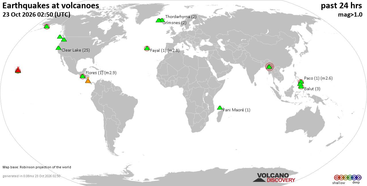
Volcano earthquake report for Friday, 23 October 2026
• M 4.7 - 94 km NNW of Coquimbo, Chile
• Moderate mag. 4.5 earthquake - 58 km SW of Atocha, Bolivia, on Friday, Oct ...
• M 0.3 - 55 km SSW of Skwentna, Alaska
• M 4.1 - 207 km ENE of Nagqu, China
• M 0.1 - 56 km SSW of Skwentna, Alaska
|
 Volcano earthquake report for Friday, 23 October 2026
Webmaster
1 hour ago
Volcano earthquake report for Friday, 23 October 2026World map showing volcanoes with shallow (less than 50 km) earthquakes within 20 km radius during the past 24 hours on 23 Oct 2026 Number in brackets indicate nr of quakes. Quakes detected near: Balut (3 quakes between mag 1.8-2.2), Clear Lake (25 quakes between mag 0.3-1.7), Fani Maoré (1 quake mag 1.6), Fayal (1 quake mag 2.8), Flores (1 quake mag 2.9), Grímsnes (2 quakes between mag 0.6-1.2)
Kilauea (1 quake mag 2.4), Krísuvík (8 quakes between mag 0.1-1.3), Loihi (4 quakes between mag 1.7-1.9), Martin (2 quakes between mag 1.1-2.3), Maunaloa (3 quakes between mag 1.5-2.7), Mount St. Helens (1 quake mag 1.7), Paco (1 quake mag 2.6), Poas (1 quake mag 1.9), Ragang (2 quakes between mag 2.5-3.4), Singu Plateau (1 quake mag 3.6), Thordarhyrna (2 quakes between mag 0.1-1.1), West Valley Segment (1 quake mag 2.1) (updated 02h50)\n\nNote: Earthquakes within 20 km from and at depths less than 50 km under active volcanoes are reported. The list is not complete because many volcanoes are not monitored and/or seismic data in high resolution is not available publicly.\n
Volcanoes with recent earthquakes above magnitude 2 or more than 10 quakes are listed below:
Balut volcano (Mindanao): 3 earthquakes up to magnitude 2.23 earthquakes occurred near (under) the volcano during 10 hours, the last being recorded quake 8 hours ago. Hypocenter depths ranged between 35.00 and 29.00 km. Earthquake details: 2.2 quake 13 km west of Sarangani, Davao Occidental, Davao, Philippines, Oct 23, 2026 03:13 am (GMT +8) (3 km WSW) 2.0 quake Celebes Sea, 25 km southwest of Sarangani Island, Philippines, Oct 22, 2026 09:25 pm (GMT +8) (14 km SW) 1.8 quake Philippine Sea, 12 km southwest of Sarangani Island, Philippines, Oct 22, 2026 04:56 pm (GMT +8) (3 km SSE) All earthquakes at BalutBalut is an 840 m island stratovolcano south of Mindanao whose last known eruption occurred between about 2 million and 11,700 years ago. Hot springs and thermally altered ground occur on its western and southwestern flanks. Clear Lake volcano (California): 25 earthquakes up to magnitude 1.7Possible earthquake swarm: 25 earthquakes occurred near (under) the volcano during 22 hours, the last being recorded quake 1 hour 35 minutes ago. Hypocenter depths ranged between 9.11 and 0.07 km. Earthquake details: (only 5 largest) 1.7 quake Sonoma County, 14 mi southwest of Clearlake, Lake County, California, United States, Oct 22, 2026 04:13 pm (GMT -7) (18 km SSW) 1.6 quake Sonoma County, 13 mi southwest of Clearlake, Lake County, California, United States, Oct 22, 2026 02:39 pm (GMT -7) (16 km SSW) 1.6 quake Sonoma County, 13 mi southwest of Clearlake, Lake County, California, United States, Oct 21, 2026 11:22 pm (GMT -7) (19 km S) 1.5 quake 25 mi north of Santa Rosa, Sonoma County, California, United States, Oct 22, 2026 06:14 pm (GMT -7) (19 km S) 1.5 quake 27 mi north of Santa Rosa, Sonoma County, California, United States, Oct 21, 2026 10:52 pm (GMT -7) (16 km SSW) All earthquakes at Clear LakeFayal volcano (Azores): magnitude 2.8 earthquakeA magnitude 2.8 earthquake occurred at the volcano 4 hours ago. The quake, which might be volcanic in origin, was located at a depth of 4.00 km depth at 19 km distance WNW from the volcano. Earthquake details: 2.8 quake North Atlantic Ocean, 33 km northwest of Ribeira Grande, Azores, Portugal, Oct 22, 2026 11:18 pm (Universal Time) (19 km WNW) All earthquakes at FayalFayal is a volcanic island in Portugal’s central Azores. Its 1957–58 Capelinhos eruption created new land offshore that soon joined the island’s western peninsula. Flores volcano (Guatemala): magnitude 2.9 earthquakeA magnitude 2.9 earthquake occurred at the volcano 20 hours ago. The quake, which might be volcanic in origin, was located at a depth of 5.00 km depth at 14 km distance WNW from the volcano. Earthquake details: 2.9 quake 22 km northeast of Cuilapa, Departamento de Santa Rosa, Guatemala, Oct 22, 2026 12:56 am (GMT -6) (14 km WNW) All earthquakes at FloresFlores, also known as Volcán Amayo, is a volcanic field about 10 km west of Jutiapa in southeastern Guatemala. Its last eruption is undated, and none are known from approximately the past 11,700 years. Kilauea volcano (Hawai'i (Big Island)): magnitude 2.4 earthquakeA magnitude 2.4 earthquake occurred at the volcano 5 hours ago. The quake, which might be volcanic in origin, was located at a depth of 1.76 km depth at 13 km distance SSE from the volcano. Earthquake details: 2.4 quake 9.5 mi south of Volcano, Hawaii County, Hawaii, United States, Oct 22, 2026 12:08 pm (GMT -10) (13 km SSE) All earthquakes at KilaueaMartin volcano (Alaska Peninsula): 2 earthquakes up to magnitude 2.32 earthquakes occurred near (under) the volcano during 9 hours, the last being recorded quake 14 hours ago. Hypocenter depths ranged between 5.00 and 5.00 km. Earthquake details: 2.3 quake Lake and Peninsula Borough, 112 mi west of Kodiak, Kodiak Island Borough, Alaska, United States, Oct 21, 2026 07:52 pm (GMT -8) (2 km NNE) 1.1 quake Lake and Peninsula Borough, 112 mi west of Kodiak, Kodiak Island Borough, Alaska, United States, Oct 22, 2026 04:25 am (GMT -8) (1 km SSW) All earthquakes at MartinMount Martin is a mostly ice-covered Alaskan stratovolcano distinguished by a steaming, ice-free summit crater containing a shallow acidic lake. Reported eruptions in 1951 and 1953 may have come from Martin, but both attributions are uncertain. Maunaloa volcano (Hawai'i (Big Island)): 3 earthquakes up to magnitude 2.73 earthquakes occurred near (under) the volcano during 7 hours, the last being recorded quake 7 hours ago. Hypocenter depths ranged between 10.05 and 0.05 km. Earthquake details: 2.7 quake 40 mi southwest of Hilo, Hawaii County, Hawaii, United States, Oct 22, 2026 09:32 am (GMT -10) (6 km S) 1.7 quake 35 mi southwest of Hilo, Hawaii County, Hawaii, United States, Oct 22, 2026 02:33 am (GMT -10) (5 km E) 1.5 quake 40 mi southwest of Hilo, Hawaii County, Hawaii, United States, Oct 22, 2026 09:32 am (GMT -10) (5 km S) All earthquakes at MaunaloaMaunaloa is a huge, frequently active shield volcano on Hawaiʻi’s Big Island. Its predominantly lava-producing eruptions include a well-documented episode in November–December 2022. Paco volcano (Mindanao): magnitude 2.6 earthquakeA magnitude 2.6 earthquake occurred at the volcano 12 hours ago. The quake, which might be volcanic in origin, was located at a depth of 5.00 km depth at 15 km distance WSW from the volcano. Earthquake details: 2.6 quake Philippine Sea, 30 km southwest of Surigao, Philippines, Oct 22, 2026 11:15 pm (GMT +8) (15 km WSW) All earthquakes at PacoPaco-Maniayao is a stratovolcano complex at the northeastern tip of Mindanao, distinguished by nested calderas, a breached crater and lava domes. Its youngest dated lava is about 90,000 ± 40,000 years old, while the date of its last eruption is unknown. Ragang volcano (Mindanao): 2 earthquakes up to magnitude 3.42 earthquakes occurred near (under) the volcano during 8 hours, the last being recorded quake 12 hours ago. Hypocenter depths ranged between 10.00 and 3.00 km. Earthquake details: 3.4 quake 41 km north of Midsayap, Cotabato, Soccsksargen, Philippines, Oct 22, 2026 03:01 pm (GMT +8) (15 km SSE) 2.5 quake Cotabato, Soccsksargen, 18 km west of Wao, Philippines, Oct 22, 2026 11:14 pm (GMT +8) (6 km S) All earthquakes at RagangRagang is a 2,790 m stratovolcano in central Mindanao with eight confirmed eruptive periods since the mid-18th century. Its last known eruption occurred in 1916 and included a lava flow. Singu Plateau volcano (Myanmar): magnitude 3.6 earthquakeA magnitude 3.6 earthquake occurred at the volcano 4 hours ago. The quake, which might be volcanic in origin, was located at a depth of 10.00 km depth at 19 km distance E from the volcano. Earthquake details: 3.6 quake Nay Pyi Taw, 42 km southwest of Mogok, Mandalay Region, Myanmar, Oct 23, 2026 05:28 am (GMT +6:30) (19 km E) All earthquakes at Singu PlateauSingu Plateau is a cluster of fissure vents and extensive lava flows in north-central Burma (Myanmar). Five of its youngest dated flows are approximately 250,000–310,000 years old. West Valley Segment volcano (North Pacific Ocean): magnitude 2.1 earthquakeA magnitude 2.1 earthquake occurred at the volcano 19 hours ago. The quake, which might be volcanic in origin, was located at a depth of 10.00 km depth at 8 km distance ESE from the volcano. Earthquake details: 2.1 quake North Pacific Ocean, 212 km southwest of Vernon, Regional District of Mount Waddington, British Columbia, Canada, Oct 21, 2026 10:24 pm (GMT -9) (8 km ESE) All earthquakes at West Valley SegmentWest Valley Segment is a submarine fissure-vent cluster at the northern end of the Juan de Fuca Ridge. No eruption is known during approximately the past 12,000 years, though nearly 14,000 earthquakes were detected there during unrest in September 2001. https://www.volcanodiscovery.com/earthquakes-volcanoes/news/385524/Volcano-earthquake-report-2026-10-23.html
0
3
Read More
|
Tropical Storm Vance Forecast Discussion Number 7
Webmaster
1 hour ago
Issued at 900 PM CST Thu Oct 22 2026 658
WTPZ42 KNHC 230239
TCDEP2
Tropical Storm Vance Discussion Number 7
NWS National Hurricane Center Miami FL EP222026
900 PM CST Thu Oct 22 2026
Satellite imagery indicates that Vance continues to become better
organized, with an expanding Central Dense Overcast, a well-defined
curved convective band wrapping into the circulation from the south,
and cloud-top temperatures as cold as -85 C. Upper-level outflow
remains well established, and recent microwave imagery reveals an
improvement in the inner-core structure compared to several hours
ago. The latest subjective Dvorak intensity estimate from TAFB was
T4.0/65 kt, in good agreement with UW-CIMSS objective estimates
ranging from 55 to 65 kt. Given these estimates and the continued
improvement in satellite presentation, the initial intensity is
raised to a conservative 60 kt.
Vance has turned northwestward, and the initial motion is estimated
at 325/5 kt. The cyclone should continue moving northwestward along
the southwestern periphery of a mid-level ridge extending over
Mexico into early Friday. A gradual turn toward the north-northwest
is expected during the next couple of days as the ridge weakens in
response to an upper-level trough over the southwestern United
States. The latest track guidance remains in good agreement through
about 60 h. Thereafter, the trough is expected to shift eastward,
leaving Vance in a region of weaker steering currents and resulting
in increasing spread among the guidance solutions. The regional
hurricane models and GFS favor a more westward track away from the
coast between days 4 and 5, while the GDMI, HCCA, TVCN, and ECMWF
maintain a more north-northwestward track toward the southwestern
and west-central coast of Mexico. Given these persistent differences
in the extended guidance, the NHC track forecast is largely
unchanged from the previous prediction and remains close to the GDMI
and HCCA aids.
Environmental conditions are expected to remain favorable for
significant strengthening during the next couple of days,
characterized by warm sea surface temperatures, low vertical wind
shear, and plenty of mid-level moisture. Guidance continues to
indicate a high likelihood of rapid intensification (RI), with
probabilities from the GFS- and ECMWF-based statistical guidance
reaching 65 to 80 percent during the next 24 h, well above
climatological values. Accordingly, the NHC intensity forecast
explicitly calls for RI during the next 24 h, with Vance forecast to
become a major hurricane by early Saturday. Thereafter, the cyclone
could encounter relatively cooler waters, potentially influenced by
upwelling associated with recent tropical cyclones, along with
increasing vertical wind shear. These factors should limit further
strengthening and support gradual weakening beginning around 60 h.
The NHC intensity forecast is similar to the previous prediction and
remains near the upper end of the guidance envelope through much of
the forecast period.
FORECAST POSITIONS AND MAX WINDS
INIT 23/0300Z 10.5N 101.9W 60 KT 70 MPH
12H 23/1200Z 10.9N 102.2W 80 KT 90 MPH
24H 24/0000Z 11.7N 102.8W 95 KT 110 MPH
36H 24/1200Z 12.5N 103.1W 105 KT 120 MPH
48H 25/0000Z 13.6N 103.5W 100 KT 115 MPH
60H 25/1200Z 14.7N 103.8W 95 KT 110 MPH
72H 26/0000Z 15.7N 104.1W 90 KT 105 MPH
96H 27/0000Z 16.7N 104.4W 90 KT 105 MPH
120H 28/0000Z 17.3N 104.6W 85 KT 100 MPH
$$
Forecaster Gibbs Source: Tropical Storm Vance Forecast Discussion Number 7
0
1
Read More
|
Tropical Storm Vance Wind Speed Probabilities Number 7
Webmaster
1 hour ago
Issued at 0300 UTC FRI OCT 23 2026 000
FOPZ12 KNHC 230238
PWSEP2
TROPICAL STORM VANCE WIND SPEED PROBABILITIES NUMBER 7
NWS NATIONAL HURRICANE CENTER MIAMI FL EP222026
0300 UTC FRI OCT 23 2026
AT 0300Z THE CENTER OF TROPICAL STORM VANCE WAS LOCATED NEAR
LATITUDE 10.5 NORTH...LONGITUDE 101.9 WEST WITH MAXIMUM SUSTAINED
WINDS NEAR 60 KTS...70 MPH...110 KM/H.
Z INDICATES COORDINATED UNIVERSAL TIME (GREENWICH)
PACIFIC DAYLIGHT TIME (PDT)...SUBTRACT 7 HOURS FROM Z TIME
HAWAIIAN STANDARD TIME (HST)...SUBTRACT 10 HOURS FROM Z TIME
WIND SPEED PROBABILITY TABLE FOR SPECIFIC LOCATIONS
CHANCES OF SUSTAINED (1-MINUTE AVERAGE) WIND SPEEDS OF AT LEAST
...34 KT (39 MPH... 63 KM/H)...
...50 KT (58 MPH... 93 KM/H)...
...64 KT (74 MPH...119 KM/H)...
FOR LOCATIONS AND TIME PERIODS DURING THE NEXT 5 DAYS
PROBABILITIES FOR LOCATIONS ARE GIVEN AS OP(CP) WHERE
OP IS THE PROBABILITY OF THE EVENT BEGINNING DURING
AN INDIVIDUAL TIME PERIOD (ONSET PROBABILITY)
(CP) IS THE PROBABILITY OF THE EVENT OCCURRING BETWEEN
00Z FRI AND THE FORECAST HOUR (CUMULATIVE PROBABILITY)
PROBABILITIES ARE GIVEN IN PERCENT
X INDICATES PROBABILITIES LESS THAN 1 PERCENT
PROBABILITIES FOR 34 KT AND 50 KT ARE SHOWN AT A GIVEN LOCATION WHEN
THE 5-DAY CUMULATIVE PROBABILITY IS AT LEAST 3 PERCENT.
PROBABILITIES FOR 34...50...64 KT SHOWN WHEN THE 5-DAY
64-KT CUMULATIVE PROBABILITY IS AT LEAST 1 PERCENT.
- - - - WIND SPEED PROBABILITIES FOR SELECTED LOCATIONS - - - -
FROM FROM FROM FROM FROM FROM FROM
TIME 00Z FRI 12Z FRI 00Z SAT 12Z SAT 00Z SUN 00Z MON 00Z TUE
PERIODS TO TO TO TO TO TO TO
12Z FRI 00Z SAT 12Z SAT 00Z SUN 00Z MON 00Z TUE 00Z WED
FORECAST HOUR (12) (24) (36) (48) (72) (96) (120)
- - - - - - - - - - - - - - - - - - - - - - - - - - - - - - - - - -
LOCATION KT
ISLAS MARIAS 34 X X( X) X( X) X( X) X( X) 1( 1) 6( 7)
SAN BLAS 34 X X( X) X( X) X( X) X( X) 1( 1) 6( 7)
P VALLARTA 34 X X( X) X( X) X( X) X( X) 1( 1) 3( 4)
15N 105W 34 X X( X) 2( 2) 20(22) 31(53) 3(56) 2(58)
15N 105W 50 X X( X) X( X) 2( 2) 16(18) 3(21) X(21)
15N 105W 64 X X( X) X( X) 1( 1) 7( 8) 2(10) X(10)
BARRA NAVIDAD 34 X X( X) X( X) X( X) 1( 1) 11(12) 11(23)
BARRA NAVIDAD 50 X X( X) X( X) X( X) X( X) 2( 2) 3( 5)
BARRA NAVIDAD 64 X X( X) X( X) X( X) X( X) X( X) 1( 1)
MANZANILLO 34 X X( X) X( X) X( X) 10(10) 24(34) 13(47)
MANZANILLO 50 X X( X) X( X) X( X) 1( 1) 8( 9) 7(16)
MANZANILLO 64 X X( X) X( X) X( X) X( X) 3( 3) 3( 6)
L CARDENAS 34 X X( X) X( X) X( X) 14(14) 12(26) 7(33)
L CARDENAS 50 X X( X) X( X) X( X) 1( 1) 2( 3) 2( 5)
L CARDENAS 64 X X( X) X( X) X( X) X( X) 1( 1) 1( 2)
ZIHUATANEJO 34 X X( X) X( X) X( X) 8( 8) 7(15) 5(20)
ZIHUATANEJO 50 X X( X) X( X) X( X) X( X) 2( 2) 1( 3)
15N 100W 34 X X( X) X( X) 2( 2) 1( 3) 1( 4) 2( 6)
ACAPULCO 34 X X( X) X( X) X( X) 2( 2) 1( 3) 2( 5)
$$
FORECASTER GIBBS Source: Tropical Storm Vance Wind Speed Probabilities Number 7
0
1
Read More
|
|
Forums60
Topics889,713
Posts924,510
Members2,960
| |
Most Online102,106
Jul 10th, 2026
|
|
|
|
|

|











































