|
|
|
0 members (),
2,616
guests, and
26
robots. |
|
Key:
Admin,
Global Mod,
Mod
|
|
S |
M |
T |
W |
T |
F |
S |
|
1
|
2
|
3
|
4
|
5
|
6
|
7
|
|
8
|
9
|
10
|
11
|
12
|
13
|
14
|
|
15
|
16
|
17
|
18
|
19
|
20
|
21
|
|
22
|
23
|
24
|
25
|
26
|
27
|
28
|
|
29
|
30
|
31
|
|
|
|
|
|
There are no members with birthdays on this day. |
Virgil
by Webmaster - Sun 01 Mar 2026 06:00:AM
|
|
|
|
|
|
|
|
|
|
|
|
|
|
|
|
|
|
|
|
|
Joined: Feb 2001
Posts: 381,904
Launch Director
|
OP

Launch Director
Joined: Feb 2001
Posts: 381,904 |
Small magnitude 3.0 earthquake 45 miles southwest of Warrnambool, Victoria, Australia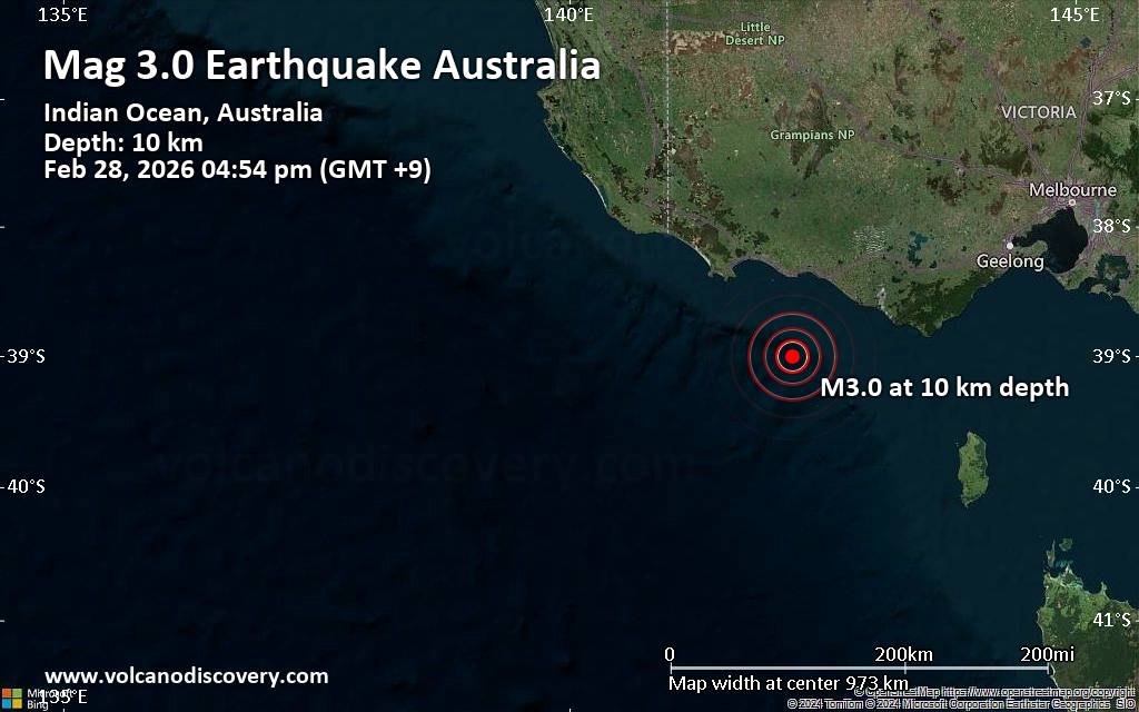 A magnitude 3.0 earthquake near Warrnambool, Victoria, Australia, was reported only 15 minutes ago by Geoscience Australia (GeoAu), considered the main national agency that monitors seismic activity in Australia. The earthquake occurred at a shallow depth of 6.2 miles beneath the epicenter in the afternoon on Saturday, February 28th, 2026, at 4:54 pm local time. The exact magnitude, epicenter, and depth of the quake might be revised within the next few hours or minutes as seismologists review data and refine their calculations, or as other agencies issue their report.
Our monitoring service identified a second report from the citizen-seismograph network of RaspberryShake which listed the quake at magnitude 3.0 as well. A third agency, the European-Mediterranean Seismological Centre (EMSC), reported the same quake at magnitude 3.0.
According to preliminary calculations, we do not expect that the quake was felt by many people and did not cause any damage. In Port Fairy (pop. 3,300, 43 miles away), Warrnambool (pop. 32,900, 45 miles away), and Dennington (pop. 1,800, 46 miles away), the quake was probably not felt.
Earthquake data: Date & time: Feb 28, 2026 04:54 pm (GMT +9) local time (28 Feb 2026 07:54 GMT)Magnitude: 3.0 Depth: 10.00 km Epicenter latitude / longitude: 39°S / 142.2°E  ( Australia) Primary data source: GeoAuhttps://www.volcanodiscovery.com/earthquake/news/296203/Small-magnitude-30-earthquake-45-miles-southwest-of-Warrnambool-Victoria-Australia.html
|
|


CMS The Best Conveyancing solicitors conveyancing quotes throughout the UK
For any webhosting enquiries please email webmaster@aus-city.com
|
|
Entire Thread
|

 Small magnitude 3.0 earthquake 45 miles southwest of Warrnambool, Victoria, Australia
|
Webmaster
|
Yesterday at 08:10 AM
|
|
Forums60
Topics763,969
Posts798,708
Members2,958
| |
Most Online17,963
Jan 15th, 2026
|
|
|
|
|
Copyright 1996 - 2026 by David Cottle. Designed by David Bate Jr. All Rights Reserved.
By using this forum, the user agrees not to transfer any data or technical information received under the agreement, to any other entity without the express approval of the AUS-CITY Forum Admins and/or authors of individual posts (Forum Admins and DoD/USSPACECOM for the analysis of satellite tracking data).
Two-line elements (TLE) and all other satellite data presented and distributed via this forum and e-mail lists of AUS-CITY are distributed with permission from DoD/USSTRATCOM.

Reprise Hosting

|

|


 - Click image for larger picture.")


