|
0 members (),
4,509
guests, and
23
robots. |
|
Key:
Admin,
Global Mod,
Mod
|
|
S |
M |
T |
W |
T |
F |
S |
|
|
|
1
|
2
|
3
|
4
|
5
|
|
6
|
7
|
8
|
9
|
10
|
11
|
12
|
|
13
|
14
|
15
|
16
|
17
|
18
|
19
|
|
20
|
21
|
22
|
23
|
24
|
25
|
26
|
|
27
|
28
|
29
|
30
|
|
|
|
|
There are no members with birthdays on this day. |
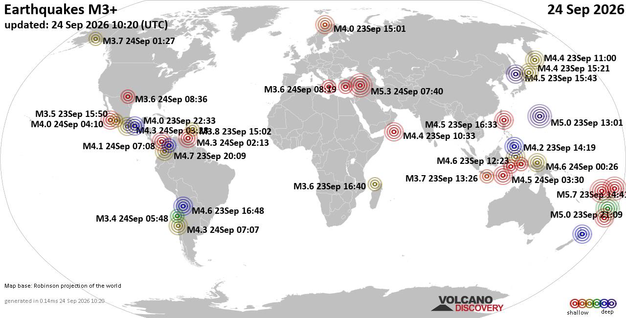
World Earthquake Report for Thursday, 24 September 2026
• Moderate mag. 4.3 earthquake - Madagascar: Mozambique Channel on Thursday, ...
• Small magnitude 3.9 earthquake hits near Hastings, Hastings District, Hawke...
• Volcano earthquake report for Thursday, 24 September 2026
• Light mag. 3.9 earthquake - South Pacific Ocean, 10.2 km south of Hastings,...
• Moderate magnitude 4.1 quake hits 31 miles southeast of Midland, Texas, Uni...
|
|
|
Joined: Feb 2001
Posts: 678,977
Launch Director
|
|
Launch Director
Joined: Feb 2001
Posts: 678,977 |
SPC Day 2 Fire Weather OutlookSPC Day 2 Fire Weather Outlook 
Day 2 Fire Weather Outlook
NWS Storm Prediction Center Norman OK
0142 PM CDT Thu Sep 24 2026

Valid 251200Z - 261200Z

Only minor adjustments were made to the Day 2/Friday Elevated fire
weather highlights across the northern Great Basin; otherwise, the
forecast remains on track. Please see the previous discussion for
details.

..Elizalde-Garcia.. 09/24/2026

.PREV DISCUSSION... /ISSUED 1256 AM CDT Thu Sep 24 2026/

...Synopsis...
A robust upper-level trough will enter the Pacific Northwest
D2/Friday. At the surface, a cold front progresses southeastward
reaching the Northern Rockies and Great Basin by late Friday.
Enhanced southwest winds prior to frontal passage will promote fire
weather concerns for northern NV into bordering OR/ID.

...Northern Nevada, far southeastern Oregon and southwestern
Idaho...
A 60-70 knot mid-level jet will shift over southeastern OR as the
upper trough pushes into the Pacific Northwest. The resultant deep
layer southwesterly flow bolstered by surface troughing stretching
from the Northern Rockies to the Great Basin will encourage
southwest winds of 15-20 mph (locally 25 mph) across portions of the
northern Great Basin. Minimum daytime RH within a well-mixed
boundary layer could reach 10-15% prior to frontal passage. Elevated
fire weather concerns are likely to evolve within the dry and breezy
conditions where adequately dry fuels exist over northern Northern
Nevada, far southeastern Oregon and southwestern Idaho. Gusty
post-frontal west/northwest winds could bring a secondary risk to
any potential wildfires but rising RH within the cooler air mass
will limit impact duration.

...Please see www.spc.noaa.gov/fire for graphic product...
Read morehttps://www.spc.noaa.gov/products/fire_wx/fwdy2.html
|
|



CMS The Best Conveyancing solicitors conveyancing quotes throughout the UK
For any webhosting enquiries please email webmaster@aus-city.com
|
|
Entire Thread
|

 SPC Day 2 Fire Weather Outlook
|
Webmaster
|
5 hours ago
|
|
Forums60
Topics840,452
Posts875,247
Members2,960
| |
Most Online102,106
Jul 10th, 2026
|
|
|





































