|
0 members (),
1,176
guests, and
26
robots. |
|
Key:
Admin,
Global Mod,
Mod
|
|
S |
M |
T |
W |
T |
F |
S |
|
|
|
|
1
|
2
|
3
|
4
|
|
5
|
6
|
7
|
8
|
9
|
10
|
11
|
|
12
|
13
|
14
|
15
|
16
|
17
|
18
|
|
19
|
20
|
21
|
22
|
23
|
24
|
25
|
|
26
|
27
|
28
|
29
|
30
|
31
|
|
|
There are no members with birthdays on this day. |
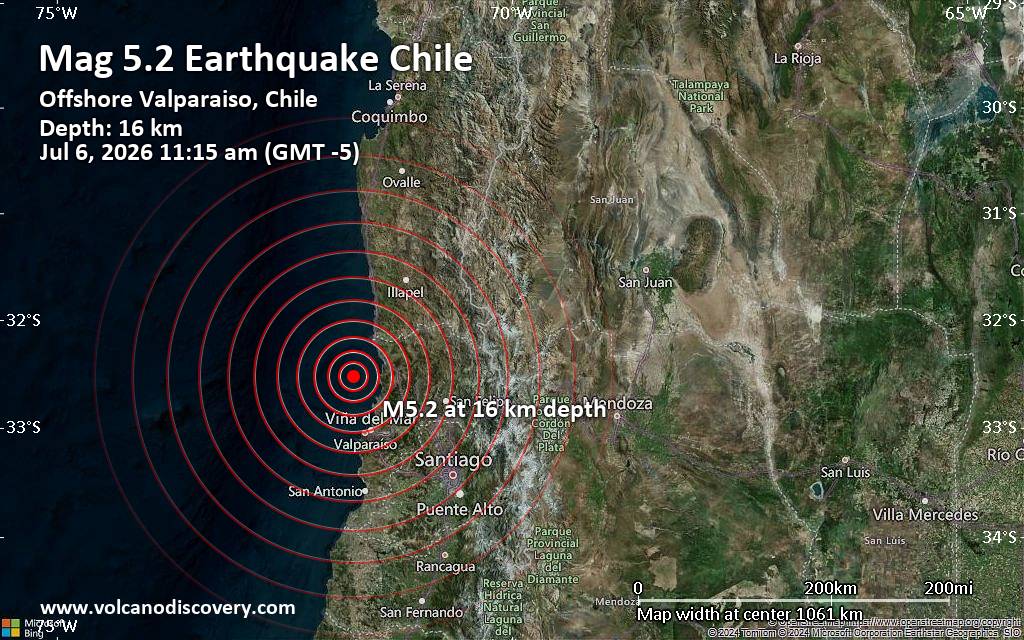
Significant magnitude 5.2 earthquake 58 km north of Valparaiso, Chile
• Small earthquake of magnitude 3.7 just reported 10 km southwest of Glogow, ...
• World Earthquake Report for Monday, 6 July 2026
• Significant 5.3 quake hits near Valparaiso, Provincia de Valparaíso, Regio...
• Moderate mag. 4.6 earthquake - South Pacific Ocean, 45 km north of Valparai...
• Strong mag. 5.2 earthquake - South Pacific Ocean, 58 km north of Valparaiso...
|

#763922
Tue 03 Jun 2025 01:01:AM
|
Joined: Feb 2001
Posts: 678,976
Launch Director
|
OP

Launch Director
Joined: Feb 2001
Posts: 678,976 |
SPC MD 1084MD 1084 CONCERNING SEVERE THUNDERSTORM WATCH 356...357... FOR SOUTHWEST AND SOUTH-CENTRAL NEBRASKA...NORTHWEST KANSAS 
Mesoscale Discussion 1084
NWS Storm Prediction Center Norman OK
0728 PM CDT Mon Jun 02 2025

Areas affected...Southwest and south-central Nebraska...northwest
Kansas

Concerning...Severe Thunderstorm Watch 356...357...

Valid 030028Z - 030230Z

The severe weather threat for Severe Thunderstorm Watch 356, 357
continues.

SUMMARY...A developing severe wind threat will soon impact northwest
Kansas. The severe threat is also expected to increase in southwest
and south-central Nebraska this evening. Severe wind gusts are the
main concern, though isolated large hail is also possible.

DISCUSSION...The strongest activity in WW 357 is within central
Nebraska. Here, inflow to storms along the front has been more
unstable/buoyant than farther northeast. The low-level jet is in the
process of strengthening per the KGLD/KDDC VAD. This should help to
sustain strong to severe storms into the evening. Furthermore,
ascent from a shortwave trough in eastern Colorado should also
contribute to an expansion of activity into southwest/south-central
Nebraska. The exact evolution of this activity is uncertain. A
cluster storms near Goodland, KS has shown a strong wind signature
on KGLD radar and has had a history of measure 64-79 mph winds. As
that activity continues north it will eventually interact with the
front to the north. The growing cluster of storms in central
Nebraska may also develop a strong enough cold pool to push
southward into larger MLCAPE.

..Wendt.. 06/03/2025

...Please see www.spc.noaa.gov for graphic product...

ATTN...WFO...OAX...GID...LBF...GLD...BOU...

LAT...LON   39760010 38970083 38970120 39080163 39350198 39740204
            40770206 41450043 41759938 41559826 41319820 40759825
            40289893 39760010

MOST PROBABLE PEAK TORNADO INTENSITY...UP TO 95 MPH
MOST PROBABLE PEAK WIND GUST...65-80 MPH
MOST PROBABLE PEAK HAIL SIZE...1.50-2.50 IN
Read morehttps://www.spc.noaa.gov/products/md/md1084.html
|
|



CMS The Best Conveyancing solicitors conveyancing quotes throughout the UK
For any webhosting enquiries please email webmaster@aus-city.com
|
|
Forums60
Topics787,241
Posts822,015
Members2,960
| |
Most Online22,463
May 9th, 2026
|
|
|