|
|
|
0 members (),
4,095
guests, and
25
robots. |
|
Key:
Admin,
Global Mod,
Mod
|
|
S |
M |
T |
W |
T |
F |
S |
|
|
1
|
2
|
3
|
4
|
5
|
6
|
|
7
|
8
|
9
|
10
|
11
|
12
|
13
|
|
14
|
15
|
16
|
17
|
18
|
19
|
20
|
|
21
|
22
|
23
|
24
|
25
|
26
|
27
|
|
28
|
29
|
30
|
|
|
|
|
|
There are no members with birthdays on this day. |

World Earthquake Report for Thursday, 4 June 2026
• Volcano earthquake report for Thursday, 4 Jun 2026
• Moderate mag. 4.1 earthquake - North Pacific Ocean, Estado de Michoacan de ...
• Moderate mag. 4.4 earthquake - Vinnytsya Oblast, 13 km southwest of Berdych...
• Moderate mag. 4.8 earthquake - Northern Mid-Atlantic Ridge on Thursday, Jun...
• Moderate mag. 4.0 earthquake - Banda Sea, 40 km southeast of Pulau Damar Is...
|

#775497
Thu 18 Sep 2025 11:50:PM
|
Joined: Feb 2001
Posts: 381,904
Launch Director
|
OP

Launch Director
Joined: Feb 2001
Posts: 381,904 |
Volcano earthquake report for Thursday, 18 Sep 2025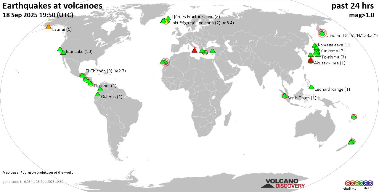 World map showing volcanoes with shallow (less than 50 km) earthquakes within 20 km radius during the past 24 hours on 18 Sep 2025 Number in brackets indicate nr of quakes. Quakes detected near: Abu (1 quake mag 1.0), Akuseki-jima (1 quake mag 2.0), Bardarbunga (2 quakes between mag 0.6-1.2), Clear Lake (19 quakes between mag 0.2-1.6), Coatepeque (1 quake mag 2.7), Coso (2 quakes between mag 0.8-1.3)
El Chichón (6 quakes between mag 2.1-2.4), Eldey (4 quakes between mag 0.3-1.0), Etna (2 quakes between mag 1.7-1.9), Fuerteventura (1 quake mag 3.0), Hrómundartindur (2 quakes between mag 0.8-1.0), Karapinar (1 quake mag 1.7), Katla (9 quakes between mag 0.6-2.9), Katmai (1 quake mag 1.2), Kilauea (1 quake mag 1.8), Klyuchevskoy (1 quake mag 1.1), Kolumbo (3 quakes between mag 0.6-2.5), Komaga-take (1 quake mag 1.0), Krísuvík (11 quakes between mag 0.1-1.3), Kuju (1 quake mag 1.6), Kurikoma (1 quake mag 1.3), Leonard Range (1 quake mag 1.5), Ljósufjöll (6 quakes between mag 0.7-2.1), Loki-Fögrufjöll volcano (2 quakes between mag 1.3-3.4), Nasu (1 quake mag 1.0), Nejapa-Miraflores (1 quake mag 1.9), Ngauruhoe (1 quake mag 1.0), Nikko-Shirane (1 quake mag 1.2), North Vate (1 quake mag 2.8), Okataina (Tarawera) (1 quake mag 2.4), Ontake-san (4 quakes between mag 0.2-1.9), Osore-yama (1 quake mag 1.2), Platanar (1 quake mag 2.0), Prestahnukur (1 quake mag 1.3), San Salvador (1 quake mag 3.0), Sarik-Gajah (1 quake mag 2.1), Suwanose-jima (28 quakes between mag 0.9-3.6), Tenerife (2 quakes between mag 0.6-1.2), Tjörnes Fracture Zone (5 quakes between mag 0.5-1.4), To-shima (7 quakes between mag 1.1-2.4), Tongariro (2 quakes between mag 1.4-1.7), Tor Zawar (1 quake mag 3.0) (updated 23h50)
Note: Earthquakes within 20 km from and at depths less than 50 km under active volcanoes are reported. The list is not complete because many volcanoes are not monitored and/or seismic data in high resolution is not available publicly.
Volcanoes with recent earthquakes above magnitude 2 or more than 10 quakes are listed below:
Clear Lake volcano (California): 19 earthquakes up to magnitude 1.6Possible earthquake swarm: 19 earthquakes occurred near (under) the volcano during 22 hours, the last being recorded quake 2 hours ago. Hypocenter depths ranged between 9.39 and 0.87 km. Earthquake details: (only 5 largest) 1.6 quake 12 mi southwest of Clearlake, Lake County, California, United States, Sep 18, 2025 11:49 am (GMT -7) (15 km S) 1.4 quake Lake County, 28 mi north of Santa Rosa, Sonoma County, California, United States, Sep 18, 2025 02:32 pm (GMT -7) (15 km S) 1.4 quake 25 mi north of Santa Rosa, Sonoma County, California, United States, Sep 18, 2025 04:54 am (GMT -7) (19 km S) 1.3 quake 27 mi north of Santa Rosa, Sonoma County, California, United States, Sep 18, 2025 12:26 am (GMT -7) (17 km SSW) 1.0 quake 27 mi north of Santa Rosa, Sonoma County, California, United States, Sep 17, 2025 08:37 pm (GMT -7) (18 km SSW) All earthquakes at Clear LakeCoatepeque volcano (El Salvador): magnitude 2.7 earthquakeA magnitude 2.7 earthquake occurred at the volcano 8 hours ago. The quake, which might be volcanic in origin, was located at a depth of 10.00 km depth at 14 km distance SE from the volcano. Earthquake details: 2.7 quake Departamento de La Libertad, 31 km west of San Salvador, El Salvador, Sep 18, 2025 09:51 am (GMT -6) (14 km SE) All earthquakes at CoatepequeEl Chichón volcano (Southern Mexico): 6 earthquakes up to magnitude 2.46 earthquakes occurred near (under) the volcano during 10 hours, the last being recorded quake 13 hours ago. Hypocenter depths ranged between 5.00 and 3.00 km. Earthquake details: (only 5 largest) 2.4 quake Estado de Chiapas, 36 km southwest of Teapa, Estado de Tabasco, Mexico, Sep 17, 2025 07:07 pm (GMT -6) (0 km S) 2.4 quake Estado de Chiapas, 37 km southwest of Teapa, Estado de Tabasco, Mexico, Sep 18, 2025 01:45 am (GMT -6) (1 km SSW) 2.4 quake Estado de Chiapas, 37 km southwest of Teapa, Estado de Tabasco, Mexico, Sep 18, 2025 04:59 am (GMT -6) (1 km S) 2.3 quake Estado de Chiapas, 35 km southwest of Teapa, Estado de Tabasco, Mexico, Sep 17, 2025 09:23 pm (GMT -6) (1 km E) 2.3 quake Estado de Chiapas, 37 km southwest of Teapa, Estado de Tabasco, Mexico, Sep 18, 2025 01:19 am (GMT -6) (1 km SSW) All earthquakes at El ChichónFuerteventura volcano (Canary Islands): magnitude 3.0 earthquakeA magnitude 3.0 earthquake occurred at the volcano 21 hours ago. The quake, which might be volcanic in origin, was located at a depth of 10.00 km depth at 15 km distance ENE from the volcano. Earthquake details: Reported seismic-like event (likely no quake): 11 km south of Puerto del Rosario, Las Palmas, Canary Islands, Spain, Sep 18, 2025 02:30 am (GMT +0) (15 km ENE) All earthquakes at FuerteventuraKatla volcano (Iceland): 9 earthquakes up to magnitude 2.99 earthquakes occurred near (under) the volcano during 21 hours, the last being recorded quake 1 hour 15 minutes ago. Hypocenter depths ranged between 1.10 and 0.10 km. Earthquake details: (only 5 largest) 2.9 quake South, 144 km east of Reykjavik, Capital Region, Iceland, Sep 18, 2025 10:34 pm (Reykjavik time) (6 km W) 2.2 quake 7.5 km NNE of Hábunga Sep 18, 2025 01:39 am (Universal Time) (2 km NNW) 1.3 quake Iceland: 8.0 km ENE of Goðabunga Sep 18, 2025 02:07 am (Reykjavik time) (3 km NW) 1.1 quake Iceland: 2.5 km ESE of Goðabunga Sep 18, 2025 10:35 pm (Reykjavik time) (7 km W) 1.1 quake Iceland: 7.8 km N of Hábunga Sep 18, 2025 01:39 am (Reykjavik time) (2 km NNW) All earthquakes at KatlaKolumbo volcano (Greece): 3 earthquakes up to magnitude 2.53 earthquakes occurred near (under) the volcano during 11 hours, the last being recorded quake 13 hours ago. Hypocenter depths ranged between 8.90 and 4.80 km. Earthquake details: 2.5 quake Aegean Sea, 28 km northeast of Santorini Island, Greece, Sep 18, 2025 01:50 pm (GMT +3) (18 km ENE) 2.3 quake Aegean Sea, 29 km northeast of Santorini Island, Greece, Sep 18, 2025 02:56 am (GMT +3) (18 km NE) 0.6 quake Aegean Sea, 6.3 km east of Santorini Island, Greece, Sep 18, 2025 06:23 am (GMT +3) (11 km SSE) All earthquakes at KolumboKrísuvík volcano (Reykjanes Peninsula, Iceland): 11 earthquakes up to magnitude 1.3Possible earthquake swarm: 11 earthquakes occurred near (under) the volcano during 14 hours, the last being recorded quake 9 hours ago. Hypocenter depths ranged between 6.50 and 2.80 km. Earthquake details: (only 5 largest) 1.3 quake Iceland: 2.9 km N of Krýsuvík Sep 18, 2025 03:05 pm (Reykjavik time) (2 km SE) 0.8 quake Iceland: 2.5 km NNE of Krýsuvík Sep 18, 2025 12:26 pm (Reykjavik time) (4 km SE) 0.8 quake Iceland: 3.9 km NNE of Krýsuvík Sep 18, 2025 12:28 pm (Reykjavik time) (4 km ESE) 0.8 quake Iceland: 4.6 km NNE of Krýsuvík Sep 18, 2025 12:41 pm (Reykjavik time) (4 km ESE) 0.6 quake Iceland: 4.0 km NE of Krýsuvík Sep 18, 2025 01:29 pm (Reykjavik time) (4 km ESE) All earthquakes at KrísuvíkLjósufjöll volcano (Iceland): 6 earthquakes up to magnitude 2.16 earthquakes occurred near (under) the volcano during 11 hours, the last being recorded quake 11 hours ago. Hypocenter depths ranged between 19.10 and 6.20 km. Earthquake details: (only 5 largest) 2.1 quake 26.2 km N of Borgarnes Sep 18, 2025 01:01 am (Universal Time) (17 km ESE) 1.9 quake Iceland: 36.0 km N of Borgarnes Sep 18, 2025 10:55 am (Reykjavik time) (13 km E) 1.6 quake 26.1 km N of Borgarnes Sep 18, 2025 04:05 am (Universal Time) (17 km ESE) 1.4 quake 25.5 km N of Borgarnes Sep 18, 2025 08:33 am (Universal Time) (18 km ESE) 0.8 quake Iceland: 29.1 km N of Borgarnes Sep 18, 2025 10:55 am (Reykjavik time) (15 km ESE) All earthquakes at LjósufjöllLoki-Fögrufjöll volcano volcano (Iceland): 2 earthquakes up to magnitude 3.42 earthquakes occurred near (under) the volcano during 5 minutes, the last being recorded quake 24 hours ago. Hypocenter depths ranged between 1.10 and 0.40 km. Earthquake details: 3.4 quake South, 212 km east of Reykjavik, Capital Region, Iceland, Sep 18, 2025 12:04 am (Universal Time) (10 km ENE) 1.3 quake 10.6 km E of Hamarinn Sep 18, 2025 12:09 am (Universal Time) (10 km ENE) All earthquakes at Loki-Fögrufjöll volcanoNorth Vate volcano (Vanuatu): magnitude 2.8 earthquakeA magnitude 2.8 earthquake occurred at the volcano 12 hours ago. The quake, which might be volcanic in origin, was located at a depth of 0 km depth at 6 km distance NNW from the volcano. Earthquake details: 2.8 quake 35 km north of Port Vila, Shefa Province, Vanuatu, Sep 18, 2025 11:07 pm (GMT +11) (6 km NNW) All earthquakes at North VateOkataina (Tarawera) volcano (New Zealand): magnitude 2.4 earthquakeA magnitude 2.4 earthquake occurred at the volcano 5 hours ago. The quake, which might be volcanic in origin, was located at a depth of 4.20 km depth at 4 km distance WSW from the volcano. Earthquake details: 2.4 quake 19 km east of Rotorua, Bay of Plenty, New Zealand, Sep 19, 2025 06:57 am (GMT +12) (4 km WSW) All earthquakes at Okataina (Tarawera)San Salvador volcano (El Salvador): magnitude 3.0 earthquakeA magnitude 3.0 earthquake occurred at the volcano 4 hours ago. The quake, which might be volcanic in origin, was located at a depth of 10.00 km depth at 14 km distance E from the volcano. Earthquake details: Reported seismic-like event (likely no quake): 5.6 km northeast of San Salvador, Departamento de San Salvador, El Salvador, Sep 18, 2025 01:45 pm (GMT -6) (14 km E) All earthquakes at San SalvadorSarik-Gajah volcano (Sumatra): magnitude 2.1 earthquakeA magnitude 2.1 earthquake occurred at the volcano 23 hours ago. The quake, which might be volcanic in origin, was located at a depth of 10.00 km depth at 9 km distance WSW from the volcano. Earthquake details: 2.1 quake Kabupaten Pasaman, 48 km northwest of Bukittinggi, Indonesia, Sep 18, 2025 08:12 am (GMT +7) (9 km WSW) All earthquakes at Sarik-GajahSuwanose-jima volcano (Ryukyu Islands): 28 earthquakes up to magnitude 3.6Possible earthquake swarm: 28 earthquakes occurred near (under) the volcano during 23 hours, the last being recorded quake 31 minutes ago. Hypocenter depths ranged between 14.80 and 0.00 km. Earthquake details: (only 5 largest) 3.6 quake 143 km north of Naze, Kagoshima-ken, Japan, Sep 19, 2025 08:07 am (GMT +9) (18 km ESE) 3.5 quake East China Sea, Kagoshima-ken, 8.8 km southeast of Suwanose-jima Island, Japan, Sep 19, 2025 08:11 am (GMT +9) (9 km ESE) 3.1 quake East China Sea, Kagoshima-ken, 8.8 km southeast of Suwanose-jima Island, Japan, Sep 19, 2025 01:46 am (GMT +9) (9 km ESE) 3.1 quake East China Sea, Kagoshima-ken, 12 km southeast of Suwanose-jima Island, Japan, Sep 19, 2025 01:45 am (GMT +9) (12 km ESE) 2.5 quake East China Sea, Kagoshima-ken, 5.5 km northwest of Suwanose-jima Island, Japan, Sep 19, 2025 06:20 am (GMT +9) (5 km NW) All earthquakes at Suwanose-jimaTo-shima volcano (Izu Islands): 7 earthquakes up to magnitude 2.47 earthquakes occurred near (under) the volcano during 6 hours, the last being recorded quake 15 hours ago. Hypocenter depths ranged between 14.00 and 8.40 km. Earthquake details: (only 5 largest) 2.4 quake North Pacific Ocean, Tokyo, 44 km southeast of Shimoda, Shizuoka, Japan, Sep 18, 2025 05:59 pm (GMT +9) (9 km E) 2.4 quake North Pacific Ocean, Tokyo, 45 km east of Shimoda, Shizuoka, Japan, Sep 18, 2025 12:31 pm (GMT +9) (14 km ENE) 1.6 quake North Pacific Ocean, Tokyo, 43 km east of Shimoda, Shizuoka, Japan, Sep 18, 2025 12:30 pm (GMT +9) (13 km ENE) 1.5 quake North Pacific Ocean, Tokyo, 42 km southeast of Shimoda, Shizuoka, Japan, Sep 18, 2025 04:33 pm (GMT +9) (7 km E) 1.3 quake North Pacific Ocean, 47 km northeast of Kozu Shima Island, Tokyo, Japan, Sep 18, 2025 06:17 pm (GMT +9) (17 km E) All earthquakes at To-shimaTor Zawar volcano (Pakistan): magnitude 3.0 earthquakeA magnitude 3.0 earthquake occurred at the volcano 2 hours ago. The quake, which might be volcanic in origin, was located at a depth of 10.00 km depth at 1 km distance SSE from the volcano. Earthquake details: Reported quake or seismic-like event: 41 km southeast of Indi, Bijapur, State of Karnataka, India, Sep 19, 2025 03:01 am (GMT +5:30) (1 km SSE) All earthquakes at Tor ZawarUnnamed 52.92°N/158.52°E volcano (Southern Kamchatka): 2 earthquakes up to magnitude 3.02 earthquakes occurred near (under) the volcano during 3 hours, the last being recorded quake 15 hours ago. Hypocenter depths ranged between 10.00 and 10.00 km. Earthquake details: Reported seismic-like event (likely no quake): 2.5 km southeast of Petropavlovsk-Kamchatskiy, Kamchatka, Russia, Sep 18, 2025 08:26 pm (GMT +12) (16 km NNE) Reported seismic-like event (likely no quake): 3.6 km west of Petropavlovsk-Kamchatskiy, Kamchatka, Russia, Sep 18, 2025 05:54 pm (GMT +12) (17 km NNE) All earthquakes at Unnamed 52.92°N/158.52°Ehttps://www.volcanodiscovery.com/earthquakes-volcanoes/news/281040/Volcano-earthquake-report-for-Thursday-18-Sep-2025.html
|
|


CMS The Best Conveyancing solicitors conveyancing quotes throughout the UK
For any webhosting enquiries please email webmaster@aus-city.com
|
|
Forums60
Topics778,622
Posts813,416
Members2,960
| |
Most Online22,463
May 9th, 2026
|
|
|
|
|
Copyright 1996 - 2026 by David Cottle. Designed by David Bate Jr. All Rights Reserved.
By using this forum, the user agrees not to transfer any data or technical information received under this agreement to any other entity without the express approval of the AUS-CITY Forum Admins and/or authors of individual posts (Forum Admins and DoD/USSPACECOM for the analysis of satellite tracking data).
Two-line elements (TLE) and all other satellite data presented and distributed via this forum and AUS-CITY mailing lists are distributed with permission from DoD/USSTRATCOM.

|

|


 - Click image for larger picture.")


