|
|
|
0 members (),
1,176
guests, and
26
robots. |
|
Key:
Admin,
Global Mod,
Mod
|
|
S |
M |
T |
W |
T |
F |
S |
|
|
|
|
1
|
2
|
3
|
4
|
|
5
|
6
|
7
|
8
|
9
|
10
|
11
|
|
12
|
13
|
14
|
15
|
16
|
17
|
18
|
|
19
|
20
|
21
|
22
|
23
|
24
|
25
|
|
26
|
27
|
28
|
29
|
30
|
31
|
|
|
There are no members with birthdays on this day. |
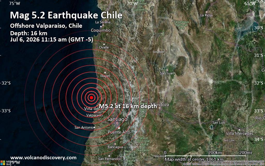
Significant magnitude 5.2 earthquake 58 km north of Valparaiso, Chile
• Small earthquake of magnitude 3.7 just reported 10 km southwest of Glogow, ...
• World Earthquake Report for Monday, 6 July 2026
• Significant 5.3 quake hits near Valparaiso, Provincia de Valparaíso, Regio...
• Moderate mag. 4.6 earthquake - South Pacific Ocean, 45 km north of Valparai...
• Strong mag. 5.2 earthquake - South Pacific Ocean, 58 km north of Valparaiso...
|

#822723
Thu 02 Jul 2026 04:27:PM
|
Joined: Feb 2001
Posts: 678,976
Launch Director
|
OP

Launch Director
Joined: Feb 2001
Posts: 678,976 |
SPC Jul 2, 2026 1630 UTC Day 1 Convective OutlookSPC 1630Z Day 1 Outlook 
Day 1 Convective Outlook
NWS Storm Prediction Center Norman OK
1124 AM CDT Thu Jul 02 2026

Valid 021630Z - 031200Z

...THERE IS AN ENHANCED RISK OF SEVERE THUNDERSTORMS THIS AFTERNOON
AND EVENING ACROSS PARTS OF EASTERN SOUTH DAKOTA...SOUTHWEST
MINNESOTA...AND NORTHWEST IOWA....

...THERE IS A SLIGHT RISK OF SEVERE THUNDERSTORMS FROM THE DAKOTAS
INTO THE WESTERN GREAT LAKES...OVER THE SOUTHERN APPALACHIANS AND
TENNESSEE VALLEY...AND OVER WESTERN KANSAS...

...SUMMARY...
Scattered severe storms will be possible from the northern Plains
into the Midwest and Great Lakes regions today into tonight, as well
as across the southern Appalachians and Tennessee Valley this
afternoon and early evening.

...SD to WI...
Morning water vapor imagery shows several weak and/or convectively
induced shortwave troughs moving across the northern Plains into the
Upper Midwest.  This area will have widespread marginal to moderate
afternoon CAPE and dewpoints in the 60s to lower 70s.  This leads to
a forecast of a large area of potential thunderstorm development,
but with weak/nebulous forcing and general height-rises aloft.  As
such, the overall confidence in this forecast is not very high.

Storms are likely to focus along a boundary currently evident from
southern SD into central IA.  Convection currently developing in
northern IA near the boundary should continue to intensify through
the afternoon and track into southern WI/northern IL with a severe
wind/hail threat.

Other intense thunderstorm clusters are expected to develop along
the SD/NE portion of the boundary by mid/late afternoon, also with a
risk of large hail and damaging wind gusts.

...Western KS...
Full sunshine and dewpoints in the 60s will lead to a region of
strong instability over western KS this afternoon. Most CAM
solutions suggest at least isolated thunderstorms form along the
KS/CO border and spread slowly eastward during the evening.  A
deeply mixed boundary layer and sufficient CAPE suggest a risk of
damaging wind gusts in the strongest cells.

...TN Valley/Southern Appalachians...
A widespread very moist and unstable air mass is present today
across this region, with full sunshine leading to steep low-level
lapse rates and MLCAPE values over 4000 J/kg.  Weak forcing under an
upper ridge limits confidence in timing/location of storms.
However, widely scattered thunderstorm development should eventually
result in merging outflows and the risk of gusty/damaging winds this
afternoon and early evening across the region.

..Hart/Halbert.. 07/02/2026
Read morehttps://www.spc.noaa.gov/products/outlook/day1otlk_1630.html
|
|



CMS The Best Conveyancing solicitors conveyancing quotes throughout the UK
For any webhosting enquiries please email webmaster@aus-city.com
|
|
Forums60
Topics787,241
Posts822,015
Members2,960
| |
Most Online22,463
May 9th, 2026
|
|
|
|
|
Copyright 1996 - 2026 by David Cottle. Designed by David Bate Jr. All Rights Reserved.
By using this forum, the user agrees not to transfer any data or technical information received under this agreement to any other entity without the express approval of the AUS-CITY Forum Admins and/or authors of individual posts (Forum Admins and DoD/USSPACECOM for the analysis of satellite tracking data).
Two-line elements (TLE) and all other satellite data presented and distributed via this forum and AUS-CITY mailing lists are distributed with permission from DoD/USSTRATCOM.

|

|