|
|
|
0 members (),
3,524
guests, and
21
robots. |
|
Key:
Admin,
Global Mod,
Mod
|
|
S |
M |
T |
W |
T |
F |
S |
|
|
|
|
1
|
2
|
3
|
4
|
|
5
|
6
|
7
|
8
|
9
|
10
|
11
|
|
12
|
13
|
14
|
15
|
16
|
17
|
18
|
|
19
|
20
|
21
|
22
|
23
|
24
|
25
|
|
26
|
27
|
28
|
29
|
30
|
|
|
|
There are no members with birthdays on this day. |
 SPC Apr 16, 2026 Day 4-8 Severe Weather Outlook
Webmaster
2 hours ago
SPC Apr 16, 2026 Day 4-8 Severe Weather Outlook
Webmaster
2 hours ago
SPC Apr 16, 2026 Day 4-8 Severe Weather OutlookDay 4-8 Outlook 
Day 4-8 Convective Outlook
NWS Storm Prediction Center Norman OK
0338 AM CDT Thu Apr 16 2026

Valid 191200Z - 241200Z

...DISCUSSION...
Severe thunderstorm potential will be low through at least Day
6/Tuesday. In the wake of a cold front moving offshore the Atlantic
coast and into the Gulf, strong surface high pressure will build
east of the Rockies and persist across parts of the South and East
through Day 6/Tuesday. As a result, a dry and stable boundary layer
will preclude severe thunderstorm potential.

By the middle of the week, and upper trough is forecast to
overspread the western U.S. As this occurs, lee surface troughing
will allow for increasing southerly winds over the Plains, and Gulf
moisture will begin to return northward Days 7-8/Wed-Thu. It remains
uncertain if the upper trough will begin to eject eastward toward
the Plains at the end of the period. If this occurs, some severe
potential may develop across the Plains, though predictability is
low.
Read morehttps://www.spc.noaa.gov/products/exper/day4-8/
0
7
Read More
|
SPC Apr 16, 2026 0730 UTC Day 3 Severe Thunderstorm Outlook
Webmaster
3 hours ago
SPC Apr 16, 2026 0730 UTC Day 3 Severe Thunderstorm OutlookSPC 0730Z Day 3 Outlook 
Day 3 Convective Outlook
NWS Storm Prediction Center Norman OK
0205 AM CDT Thu Apr 16 2026

Valid 181200Z - 191200Z

...THERE IS A SLIGHT RISK OF SEVERE THUNDERSTORMS ACROSS PORTIONS OF
THE OHIO VALLEY...

...SUMMARY...
Isolated strong to severe thunderstorms capable of damaging winds
and hail will be possible on Saturday across part of the Ohio
Valley.

...Ohio Valley...

A large-scale upper trough oriented over the Upper Midwest and
Plains will shift east over the Great Lakes, Midwest and TN Valley
on Saturday/Saturday night. Strong deep-layer southwesterly flow
will overspread the Ohio Valley ahead of an eastward-advancing cold
front. This front should be located from Lower MI into southeast MO
Saturday morning, moving across the Ohio Valley through early
evening. Modest boundary-layer moisture will be in place ahead of
the front. Daytime heating into the 70s and modestly steep midlevel
lapse rates will support weak destabilization (generally less than
1000 J/kg MLCAPE). While instability will be modest, strong low and
midlevel flow will support organized cells and/or line segments
capable of strong gusts. Any discrete cellular activity also may
produce marginally severe hail. These severe risk should gradually
wane during the evening with eastward extent.

...TX to the Lower MS Valley...

Thunderstorms are expected along a southeast-advancing cold front
Saturday afternoon and evening. Deep-layer flow will be oriented
parallel to the front, and convection may largely be anafrontal or
quickly undercut by the front. While weak MUCAPE is noted in
forecast soundings, severe potential is not expected at this time.

..Leitman.. 04/16/2026
Read morehttps://www.spc.noaa.gov/products/outlook/day3otlk_0730.html
0
6
Read More
|
SPC Day 2 Fire Weather Outlook
Webmaster
3 hours ago
SPC Day 2 Fire Weather OutlookSPC Day 2 Fire Weather Outlook 
Day 2 Fire Weather Outlook
NWS Storm Prediction Center Norman OK
0206 AM CDT Thu Apr 16 2026

Valid 171200Z - 181200Z

...CRITICAL FIRE WEATHER AREA FOR PORTIONS OF THE SOUTHERN HIGH
PLAINS....

...Synopsis...
An upper trough will move into the central U.S. and deepen Friday as
an associated mid-level speed max intensifies over the central
Plains. A deepening surface low and a strong cold front will promote
critical fire weather conditions over the southern Plains. A second
shortwave impulse will exit the eastern U.S. supporting above normal
temperatures and some lingering dry/breezy conditions over the
central Appalachians and Carolinas.

...TX/NM...
As the primary shortwave trough over the Great Basin begins to eject
eastward, strong flow aloft will overspread the southern High
Plains. The surface low in eastern CO is forecast to deepen as it
lifts northeastward, dragging the front southward. Gusty southwest
surface winds, bolstered by westerly flow aloft, will develop across
eastern NM, into the TX/OK Panhandles by mid morning. Gusts of 30-40
mph are possible. Warm temperatures west of the dryline will support
RH minimums below 15%. Widespread critical fire-weather conditions
are likely within dry fuels.

Farther north, gusty post-frontal winds are possible over parts of
southwestern KS and the central Plains. RH values will climb quickly
through the day as temperatures cool. Brief elevated fire-weather
conditions are possible where fuels have remained dry. The front
will continue to move south into TX/OK/NM Friday afternoon and into
the evening. This will likely result in a rapid wind shift which
could locally exacerbate burning conditions briefly. Adjustments to
the northern edge of the Elevated and Critical areas could also be
necessary as uncertainty on frontal timing is reduced in subsequent
updates.

...Central Appalachians...
In the wake of the departing shortwave trough, flow aloft is
forecast to weaken over much of the Appalachians. Still, residual
westerly flow may encourage lee troughing, helping to bolster
downslope winds to near 10 mph. With very warm/dry surface
conditions expected with subsequent mid-level ridging, low afternoon
RH is expected. This, in combination with no recent rainfall and
critical fuels, should support a few hours of elevated fire-weather
conditions from VA, into the western Carolinas.

..Lyons.. 04/16/2026

...Please see www.spc.noaa.gov/fire for graphic product...
Read morehttps://www.spc.noaa.gov/products/fire_wx/fwdy2.html
0
6
Read More
|
SPC Day 1 Fire Weather Outlook
Webmaster
3 hours ago
SPC Day 1 Fire Weather OutlookSPC Day 1 Fire Weather Outlook 
Day 1 Fire Weather Outlook
NWS Storm Prediction Center Norman OK
0204 AM CDT Thu Apr 16 2026

Valid 161200Z - 171200Z

...CRITICAL FIRE WEATHER AREA FOR FOR PORTIONS OF THE CENTRAL AND
SOUTHERN HIGH PLAINS....

...Synopsis...
An upper-level trough will deepen as it moves into the southern
Great Basin/Four Corners today and tonight. As the trough
intensifies, an initially modest subtropical jet will strengthen
across northern Mexico into the southern Plains. At the surface, a
strong low pressure system will deepen across SD as an associated
cold front moves southward into the central Plains. Another
shortwave trough will move over the eastern US bolstering low-level
winds across parts of the Appalachians and Mid Atlantic.

...Central and Southern High Plains...
As upper forcing from the approaching trough spreads over the
Rockies into the plains, the surface low will deepen and move
southeastward with the cold front. This should encourage a broad
area of strong west/southwesterly downslope winds from eastern WY
and SD, into parts of the central Plains. Sustained southwesterly
winds of 15-25 mph (gusts up to 30 mph) amid 10-15 percent RH are
expected atop very dry and receptive fuels, supporting critical fire
weather concerns. Fire-weather conditions will gradually end
overnight from north to south as the front moves south with the
surface low.

Farther south across OK/TX and NM, a surface pressure trough will
encourage gusty westerly low-level flow. Sustained winds of 15-25
mph are likely as the surface low gradually moves southward ahead of
the cold front. Low RH is also expected (10-15%) owing to downslope
trajectories and warm afternoon temperatures. While some areas have
seen rainfall in the past few days, several days of poor humidity
recoveries and gusty winds have allowed for significant drying and a
broad area of critical fuels.

...Central Appalachians and Mid Atlantic...
Strengthening southwesterly flow at the base of the shortwave tough
will encourage strengthening of a lee trough. This will aid gusty
downslope winds of 10-15 mph through the afternoon. Afternoon RH
values will drop to 25-30%. With little recent rainfall and very dry
fuels, several hours of elevated fire-weather conditions appear
likely. More localized fire-weather conditions could extend into
southern and central PA. However, here increased RH and weaker winds
amid areas of recent rainfall should limit broader concerns.

..Lyons.. 04/16/2026

...Please see www.spc.noaa.gov/fire for graphic product...
Read morehttps://www.spc.noaa.gov/products/fire_wx/fwdy1.html
0
6
Read More
|
SPC Apr 16, 2026 0600 UTC Day 1 Convective Outlook
Webmaster
4 hours ago
SPC Apr 16, 2026 0600 UTC Day 1 Convective OutlookSPC 1200Z Day 1 Outlook 
Day 1 Convective Outlook CORR 1
NWS Storm Prediction Center Norman OK
0109 AM CDT Thu Apr 16 2026

Valid 161200Z - 171200Z

...THERE IS A SLIGHT RISK OF SEVERE THUNDERSTORMS THIS AFTERNOON
ACROSS PARTS OF WESTERN AND CENTRAL NEW YORK INTO SOUTHERN
VERMONT...

CORRECTED FOR TYPOS AND WORDING

...SUMMARY...
A few severe thunderstorms are possible this afternoon in a corridor
across western through central New York (state) and adjacent
southern Vermont.

...Discussion...
A significant mid-level trough and embedded low now digging across
the Pacific Northwest is forecast to split as it continues inland
through this period.  One perturbation, perhaps including a
continuing cyclonic circulation, is forecast to turn eastward across
the northern Rockies through the central Canadian/U.S. border area.
Another perturbation is forecast to dig southeastward across the
Great Basin into early Friday.  It appears that the larger-scale
evolving troughing will be preceded by a significant cold frontal
surge to the lee of the northern U.S. Rockies, through much of the
northern and central Great Plains by 12Z Friday.

Downstream, initially prominent mid-level ridging centered near the
southern Atlantic Seaboard is forecast to become increasingly
suppressed, as one short wave trough, approaching southwestern
portions of the Great Lakes region early today, turns eastward then
southeastward across the lower Great Lakes vicinity into northern
Mid Atlantic.  It appears that this will be trailed by another
perturbation, which is forecast to progress east of the Ozark
Plateau through the lower Ohio and Tennessee Valleys, before digging
across the southern Appalachians, downstream of short wave ridging
building across and east of the mid/upper Mississippi Valley.

...Mid South into lower Great Lakes and Northeast...
The primary and trailing short wave troughs advancing to the east of
the Mississippi Valley are forecast to be preceded by the remnants
of overnight convection across parts of the lower Great Lakes, Ohio
Valley, and Mid South at the outset of the period.  The impacts of
associated cloud cover and outflow on destabilization within the
warm sector of a broad, but weak, surface low migrating northeast of
the lower Great Lakes during the day remain unclear.  However,
various model output, including convection allowing guidance,
suggest that destabilization and strengthening shear along a warm
frontal zone (as it strengthens with differential heating) may
become a focus for organized strong thunderstorm development across
New York state by afternoon.  It appears that this may include an
evolving cluster, perhaps preceded by more discrete thunderstorm
activity, in an environment conducive to evolving supercell
structures, with potential to produce severe hail, wind and a risk
for a couple of tornadoes.

Additional thunderstorm activity may eventually develop and
strengthen, accompanied by at least a risk for strong to severe wind
gusts by late afternoon, in a corridor of stronger daytime heating
ahead of a developing cold front spreading into the upper Ohio
Valley/Allegheny and Cumberland Plateau.

Farther west/southwest, there is not a well-defined signal in the
latest model output, but a corridor of differential surface heating
along weakening trailing convective outflow across the Mid South
vicinity could become a focus for supercell development.  It
currently appears that this potential could peak across north
central into northeastern Arkansas by late this afternoon, aided by
moderate boundary-layer destabilization and stronger mid-level
forcing for ascent associated with a cyclonic vorticity center
migrating across the region.

...Southern Great Plains...
Moderate to strong potential instability is forecast to develop
beneath steep lapse rates, along and east of a dryline which likely
will be retreating westward across the high plains by early this
evening.  While this will be conditionally supportive of severe
thunderstorm development, forcing to support initiation of sustained
thunderstorms remains unclear, aside from, perhaps, the higher
terrain near/east of the Texas Big Bend.  Beneath moderate to strong
southwesterly mid/upper flow, this could include an isolated
supercell or two which could propagate across the Rio Grande River,
before weakening in the presence of increasing inhibition this
evening.

..Kerr/Lyons.. 04/16/2026
Read morehttps://www.spc.noaa.gov/products/outlook/day1otlk_1200.html
0
7
Read More
|
SPC Apr 16, 2026 0600 UTC Day 2 Convective Outlook
Webmaster
4 hours ago
SPC Apr 16, 2026 0600 UTC Day 2 Convective OutlookSPC 0600Z Day 2 Outlook 
Day 2 Convective Outlook
NWS Storm Prediction Center Norman OK
1257 AM CDT Thu Apr 16 2026

Valid 171200Z - 181200Z

...THERE IS AN ENHANCED RISK OF SEVERE THUNDERSTORMS ACROSS PORTIONS
OF OKLAHOMA...KANSAS...MISSOURI...IOWA...ILLINOIS...FAR SOUTHEAST
MINNESOTA...AND WISCONSIN...

...SUMMARY...
Widespread severe thunderstorms are expected from parts of the
southern Plains to the Middle and Upper Mississippi Valley vicinity
Friday into Friday night. Tornadoes, possibly strong, very large
hail, and swaths of damaging winds will be possible.

...Southern Plains to Upper Midwest...

A potent upper trough from is expected to eject over the Plains and
Upper Midwest on Friday. Strong deep-layer southwesterly flow will
overspread the region early in the forecast period, with 850-700 mb
flow around 40-50 kt common from parts of OK/KS into WI. At the
surface, forecast guidance has trended a bit further north with the
position of a surface low Friday morning. This low is expected to be
located along the MO River near the SD/IA/NE border, and will
develop northeast into northern WI/MI U.P. by late afternoon. A
trailing cold front will push southeast across Upper MS/Mid-MO
Valley as this occur, becoming oriented from central MI to northwest
MO and southeast KS by 00z. Meanwhile, a second low is forecast to
develop over the TX Panhandle/western OK within strong heating near
a dryline extending southwest from western OK into
west-central/western TX. Ahead of these surface features, a
seasonally moist airmass will be in place, or, in the case of the
Upper Midwest, rapidly advect northward during the morning hours.

A plume of steep midlevel lapse rates, supported by cool to cold
temperatures aloft (near -16 C at 500 MB across portions of IA/MN/WI
at 21z, and -14 to -12 C further southwest) will overspread the
moist boundary layer. This will result in strong destabilization,
with MLCAPE around 2500-3500 J/kg expected across the warm sector.
This kinematic and thermodynamic environment will support robust
convective development near the Upper Midwest surface low
southwestward along the cold front into KS by midday. Initial
supercells are possible, especially closer to the surface low in the
Upper Midwest, and near the triple point/dryline in northwest
OK/south-central KS. More rapid upscale growth into a robust
line/LEWP is expected along the cold front from parts of IA into MO
and eastern KS. Given robust instability and very steep lapse rates,
significant damaging wind swaths will be possible. Additionally,
large to very large hail will be possible with any discrete
supercells, and possibly within line-embedded supercells. Low-level
wind profiles will also support a aerially extensive tornado risk,
both with QLCS mesovortex circulations, and with discrete
supercells. A corridor of perhaps greater tornado risk/coverage may
develop near the surface low from northeast IA into central WI.
Low-level SRH will be maximized in this area and forecast soundings
indicate large, curved hodographs becoming elongated above 2-3 km.
Furthermore, mixing ratios near 14 g/kg and very steep lapse rates
should support robust updrafts with low cloud bases. This are may
become a focused corridor for stronger tornadoes.

Linear convection should continue east across the MS River and Lake
Michigan during the evening and overnight hours, with a gradually
waning severe risk into portions of central/southern IL, Lower MI
and IN. Additional convection may develop during the evening and/or
overnight across parts of TX near the dryline, though this scenario
is more conditional. If storms do develop, large will be the main
risk.

..Leitman.. 04/16/2026
Read morehttps://www.spc.noaa.gov/products/outlook/day2otlk_0600.html
0
6
Read More
|
Volcano earthquake report for Thursday, 16 Apr 2026
Webmaster
6 hours ago
Volcano earthquake report for Thursday, 16 Apr 2026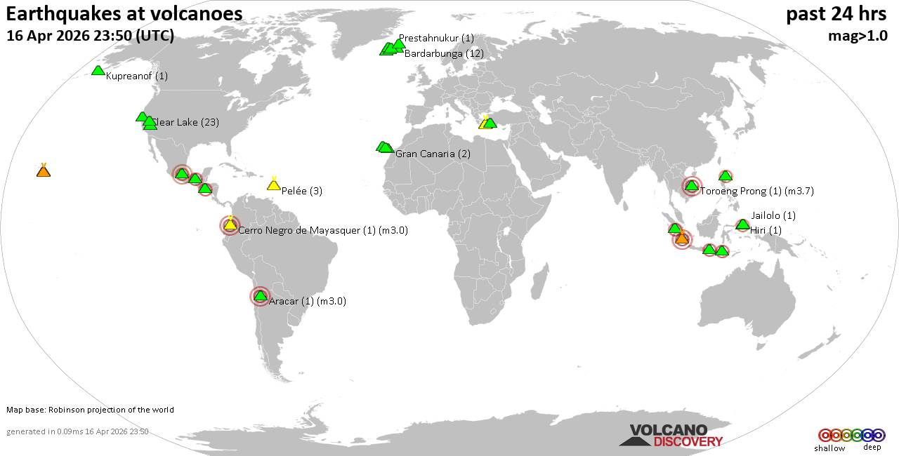 World map showing volcanoes with shallow (less than 50 km) earthquakes within 20 km radius during the past 24 hours on 16 Apr 2026 Number in brackets indicate nr of quakes. Quakes detected near: Baluran (3 quakes between mag 2.6-3.0), Clear Lake (31 quakes between mag 0.2-1.7), Davidof (1 quake mag 1.1), El Chichón (2 quakes between mag 2.1-2.2), Eldey (8 quakes between mag 0.6-1.3), Etna (1 quake mag 1.2)
Gran Canaria (1 quake mag 1.6), Hulubelu (2 quakes between mag 2.0-2.5), Iliboleng (1 quake mag 2.0), Kenger (1 quake mag 1.4), Kilauea (4 quakes between mag 1.4-1.9), Kolumbo (2 quakes between mag 1.8-2.1), Korovin (1 quake mag 1.2), Krísuvík (7 quakes between mag 0.0-1.4), La Palma (1 quake mag 1.6), Ljósufjöll (1 quake mag 1.9), Maunaloa (1 quake mag 1.6), Methana (1 quake mag 1.3), Muria (1 quake mag 2.4), Nemrut Dagi (1 quake mag 1.2), Newberry (1 quake mag 1.7), Patah (1 quake mag 3.3), Pelée (14 quakes between mag 0.2-1.5), Raung (1 quake mag 2.6), Taupo (1 quake mag 2.4), Tenerife (4 quakes between mag 0.9-1.4), Tjörnes Fracture Zone (5 quakes between mag 0.7-2.0), Vulcano (1 quake mag 1.8) (updated 04h50)
Note: Earthquakes within 20 km from and at depths less than 50 km under active volcanoes are reported. The list is not complete because many volcanoes are not monitored and/or seismic data in high resolution is not available publicly.
Volcanoes with recent earthquakes above magnitude 2 or more than 10 quakes are listed below:
Baluran volcano (East Java): 3 earthquakes up to magnitude 3.03 earthquakes occurred near (under) the volcano during 6 hours, the last being recorded quake 8 hours ago. Hypocenter depths ranged between 9.00 and 5.00 km. Earthquake details: 3.0 quake 16 km northwest of Wongsorejo, Kabupaten Banyuwangi, Jawa Timur, Indonesia, Apr 16, 2026 04:00 am (GMT +7) (9 km WSW) 2.6 quake Kabupaten Situbondo, 13 km north of Wongsorejo, Indonesia, Apr 15, 2026 09:49 pm (GMT +7) (4 km SSE) 2.6 quake Kabupaten Situbondo, 17 km north of Wongsorejo, Indonesia, Apr 15, 2026 10:04 pm (GMT +7) (2 km NE) All earthquakes at BaluranClear Lake volcano (California): 31 earthquakes up to magnitude 1.7Possible earthquake swarm: 31 earthquakes occurred near (under) the volcano during 23 hours, the last being recorded quake 34 minutes ago. Hypocenter depths ranged between 12.55 and 0.68 km. Earthquake details: (only 5 largest) 1.7 quake Sonoma County, 14 mi southwest of Clearlake, Lake County, California, United States, Apr 15, 2026 08:18 pm (GMT -7) (17 km SSW) 1.7 quake Sonoma County, 14 mi southwest of Clearlake, Lake County, California, United States, Apr 15, 2026 12:44 pm (GMT -7) (16 km SSW) 1.5 quake 26 mi north of Santa Rosa, Sonoma County, California, United States, Apr 15, 2026 07:25 pm (GMT -7) (18 km S) 1.3 quake Lake County, 28 mi north of Santa Rosa, Sonoma County, California, United States, Apr 15, 2026 01:00 pm (GMT -7) (15 km S) 1.3 quake 26 mi north of Santa Rosa, Sonoma County, California, United States, Apr 15, 2026 07:50 pm (GMT -7) (18 km S) All earthquakes at Clear LakeEl Chichón volcano (Southern Mexico): 2 earthquakes up to magnitude 2.22 earthquakes occurred near (under) the volcano during 13 hours, the last being recorded quake 9 hours ago. Hypocenter depths ranged between 3.00 and 3.00 km. Earthquake details: 2.2 quake Estado de Chiapas, 35 km southwest of Teapa, Estado de Tabasco, Mexico, Apr 15, 2026 12:53 am (GMT -6) (2 km E) 2.1 quake Estado de Chiapas, 36 km southwest of Teapa, Estado de Tabasco, Mexico, Apr 15, 2026 01:45 pm (GMT -6) (1 km ESE) All earthquakes at El ChichónHulubelu volcano (Sumatra): 2 earthquakes up to magnitude 2.52 earthquakes occurred near (under) the volcano during 9 hours, the last being recorded quake 13 hours ago. Hypocenter depths ranged between 4.00 and 3.00 km. Earthquake details: 2.5 quake Kabupaten Tanggamus, 73 km west of Bandar Lampung, Indonesia, Apr 15, 2026 02:11 pm (GMT +7) (4 km SE) 2.0 quake Kabupaten Tanggamus, 76 km west of Bandar Lampung, Indonesia, Apr 15, 2026 10:41 pm (GMT +7) (8 km NNE) All earthquakes at HulubeluKolumbo volcano (Greece): 2 earthquakes up to magnitude 2.12 earthquakes occurred near (under) the volcano during 18 hours, the last being recorded quake 4 hours ago. Hypocenter depths ranged between 13.40 and 8.60 km. Earthquake details: 2.1 quake Aegean Sea, 28 km northeast of Santorini Island, Greece, Apr 16, 2026 03:26 am (GMT +3) (16 km NE) 1.8 quake Aegean Sea, 24 km northeast of Santorini Island, Greece, Apr 15, 2026 09:18 am (GMT +3) (13 km NE) All earthquakes at KolumboMuria volcano (Central Java): magnitude 2.4 earthquakeA magnitude 2.4 earthquake occurred at the volcano 15 hours ago. The quake, which might be volcanic in origin, was located at a depth of 6.00 km depth at 10 km distance WSW from the volcano. Earthquake details: 2.4 quake 10.7 km northeast of Pecangaan, Indonesia, Apr 15, 2026 08:27 pm (GMT +7) (10 km WSW) All earthquakes at MuriaPatah volcano (Sumatra): magnitude 3.3 earthquakeA magnitude 3.3 earthquake occurred at the volcano 8 hours ago. The quake, which might be volcanic in origin, was located at a depth of 4.00 km depth at 16 km distance NNE from the volcano. Earthquake details: 3.3 quake Kota Pagar Alam, 15 km southeast of Pagar Alam, Indonesia, Apr 16, 2026 03:22 am (GMT +7) (16 km NNE) All earthquakes at PatahPelée volcano (Caribbean): 14 earthquakes up to magnitude 1.5Possible earthquake swarm: 14 earthquakes occurred near (under) the volcano during 14 hours, the last being recorded quake 9 hours ago. Hypocenter depths ranged between 0.38 and 0.00 km. Earthquake details: (only 5 largest) 1.5 quake 25 km northwest of Fort-de-France, Martinique, Apr 15, 2026 03:56 am (GMT -4) (1 km S) 1.1 quake 25 km northwest of Fort-de-France, Martinique, Apr 15, 2026 02:27 am (GMT -4) (1 km S) 0.9 quake 25 km northwest of Fort-de-France, Martinique, Apr 15, 2026 03:55 am (GMT -4) (1 km SSE) 0.8 quake 25 km northwest of Fort-de-France, Martinique, Apr 15, 2026 08:23 am (GMT -4) (1 km SSE) 0.8 quake 26 km northwest of Fort-de-France, Martinique, Apr 15, 2026 03:55 am (GMT -4) (1 km S) All earthquakes at PeléeRaung volcano (East Java): magnitude 2.6 earthquakeA magnitude 2.6 earthquake occurred at the volcano 15 hours ago. The quake, which might be volcanic in origin, was located at a depth of 8.00 km depth at 13 km distance NW from the volcano. Earthquake details: 2.6 quake 21 km southeast of Bondowoso, Kabupaten Bondowoso, Jawa Timur, Indonesia, Apr 15, 2026 08:46 pm (GMT +7) (13 km NW) All earthquakes at RaungTaupo volcano (New Zealand): magnitude 2.4 earthquakeA magnitude 2.4 earthquake occurred at the volcano 23 hours ago. The quake, which might be volcanic in origin, was located at a depth of 5.00 km depth at 19 km distance NNE from the volcano. Earthquake details: 2.4 quake 2.5 km north of Taupo, Waikato, New Zealand, Apr 15, 2026 05:41 pm (GMT +12) (19 km NNE) All earthquakes at Taupohttps://www.volcanodiscovery.com/earthquakes-volcanoes/news/300044/Volcano-earthquake-report-for-Thursday-16-Apr-2026.html
0
13
Read More
|
Seismic-like event, possible earthquake, reported few minutes ago Indonesia
Webmaster
7 hours ago
Seismic-like event, possible earthquake, reported few minutes ago Indonesia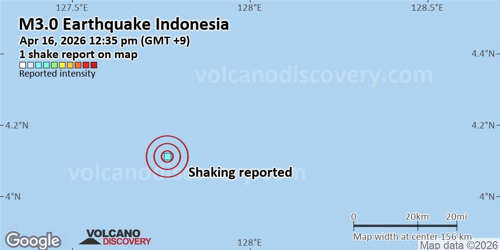 Unconfirmed quake or seismic-like event reported: 207 km southeast of Miangas, Sulawesi Utara, Indonesia, 4 minutes ago We are receiving unverified early reports of ground shaking possibly caused by seismic activity in or near Indonesia on 16 Apr 2026 (GMT) at approximately 03:35 GMT.
There are no details yet on the magnitude or depth of this possible quake. If confirmed, we can expect more accurate data to emerge in the next few minutes. The location, magnitude and time mentioned are indicative, based on our best-fit seismic model. They are temporary until our AllQuakes monitoring service receives more exact scientific data from a national or international seismological agency. Check back here shortly and stay safe.
Earthquake data: Date & time: Apr 16, 2026 12:35 pm (GMT +9) local time (16 Apr 2026 03:35 GMT)Magnitude: unspecified Depth: unspecified Epicenter latitude / longitude: 4.11°N / 127.77°E  ( Sulawesi Utara, Indonesia) Primary data source: VolcanoDiscoveryhttps://www.volcanodiscovery.com/earthquake/news/300049/Seismic-like-event-possible-earthquake-reported-few-minutes-ago-Indonesia.html
0
48
Read More
|
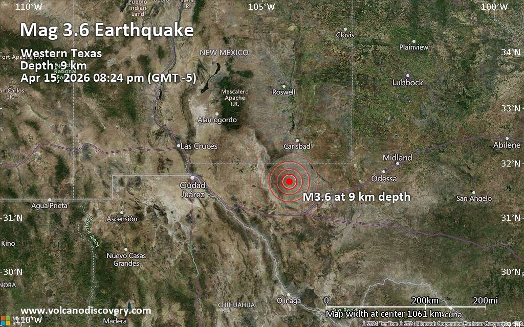
Small magnitude 3.6 earthquake 53 miles south of Carlsbad, Texas, United States
Webmaster
9 hours ago
Small magnitude 3.6 earthquake 53 miles south of Carlsbad, Texas, United StatesJust 12 minutes ago, a 3.6-magnitude earthquake struck near Carlsbad, Eddy County, New Mexico, USA. The tremor was recorded in the evening on Wednesday, April 15th, 2026, at 8:24 pm local time, at a very shallow depth of 5.3 miles below the surface.
The event was filed by the European-Mediterranean Seismological Centre (EMSC), the first seismological agency to report it.
According to preliminary calculations, we do not expect that the quake was felt by many people and did not cause any damage. In Malaga (pop. 150, 43 miles away), Van Horn (pop. 1,900, 50 miles away), and Carlsbad (pop. 29,000, 53 miles away), the quake was probably not felt.
Earthquake data: Date & time: Apr 16, 2026 01:24 am (Universal Time) local time (16 Apr 2026 01:24 GMT)Magnitude: 3.5 Depth: 6.10 km Epicenter latitude / longitude: 31.67°N / 104.39°W  ( Culberson County, Texas, United States) Primary data source: USGShttps://www.volcanodiscovery.com/earthquake/news/300045/Small-magnitude-36-earthquake-53-miles-south-of-Carlsbad-Texas-United-States.html
0
102
Read More
|
World Earthquake Report for Wednesday, 15 April 2026
Webmaster
10 hours ago
World Earthquake Report for Wednesday, 15 April 2026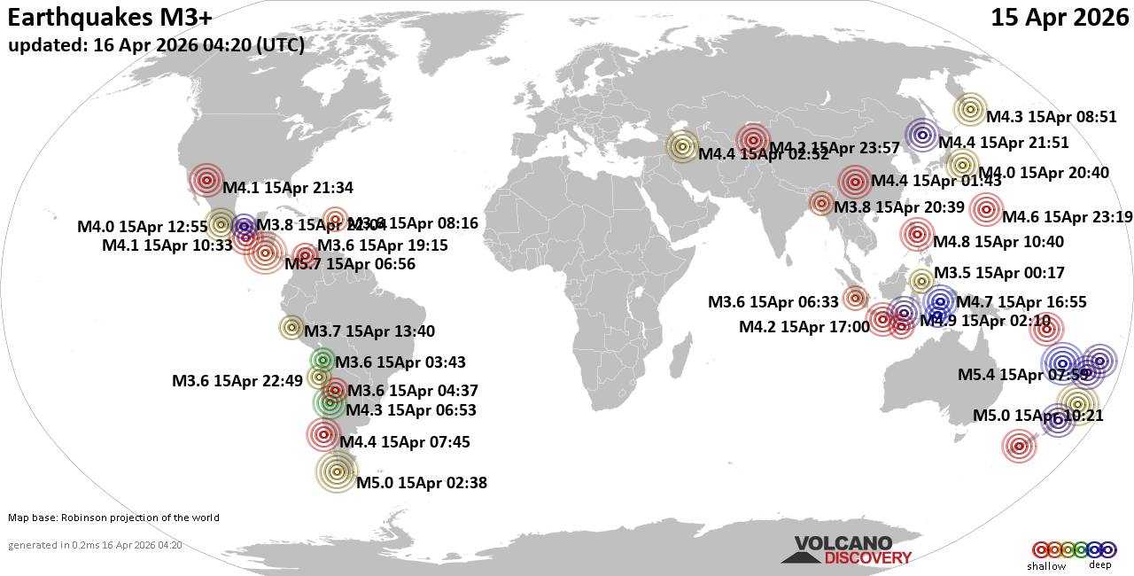 Worldwide earthquakes above magnitude 3 during the past 24 hours on 16 Apr 2026 Magnitude 5+: 5 earthquakes Magnitude 4+: 37 earthquakes Magnitude 3+: 179 earthquakes Magnitude 2+: 346 earthquakes No quakes of magnitude 6 or higher 10 largest earthquakes in the world (15 Apr 2026)Wednesday, Apr 15, 2026, at 12:56 am (GMT -6) - Wednesday, Apr 15, 2026, at 12:56 pm (GMT -6) - Wednesday, Apr 15, 2026, at 06:59 pm (GMT +11) - Tuesday, Apr 14, 2026, at 11:38 pm (GMT -3) - Wednesday, Apr 15, 2026, at 10:21 pm (GMT +12) - Wednesday, Apr 15, 2026, at 10:10 am (GMT +8) - Wednesday, Apr 15, 2026, at 06:27 pm (GMT +11) - Wednesday, Apr 15, 2026, at 06:40 pm (GMT +8) - Thursday, Apr 16, 2026, at 01:55 am (GMT +9) - Wednesday, Apr 15, 2026, at 05:09 am (GMT -12) - Earthquakes reported feltWednesday, Apr 15, 2026, at 12:56 am (GMT -6) - Wednesday, Apr 15, 2026, at 04:07 pm (GMT +2) - Wednesday, Apr 15, 2026, at 02:07 pm (GMT +2) - Wednesday, Apr 15, 2026, at 09:55 am (GMT -6) - Wednesday, Apr 15, 2026, at 09:21 am (GMT +8) - Thursday, Apr 16, 2026, at 07:18 am (GMT +12) - Wednesday, Apr 15, 2026, at 04:00 am (GMT +2) - Wednesday, Apr 15, 2026, at 10:10 am (GMT +8) - Wednesday, Apr 15, 2026, at 06:40 pm (GMT +8) - Tuesday, Apr 14, 2026, at 06:40 pm (GMT -6) - Wednesday, Apr 15, 2026, at 02:34 pm (GMT -7) - Wednesday, Apr 15, 2026, at 07:26 am (GMT +7) - Wednesday, Apr 15, 2026, at 03:53 am (GMT -3) - Thursday, Apr 16, 2026, at 01:30 am (GMT +3) - Thursday, Apr 16, 2026, at 01:02 am (GMT +2) - Wednesday, Apr 15, 2026, at 07:51 am (GMT -7) - Thursday, Apr 16, 2026, at 12:03 am (GMT +8) - Thursday, Apr 16, 2026, at 02:09 am (GMT +5:30) - Wednesday, Apr 15, 2026, at 12:56 pm (GMT -6) - Wednesday, Apr 15, 2026, at 12:58 am (GMT -5) - Wednesday, Apr 15, 2026, at 12:30 pm (GMT +3:30) - Wednesday, Apr 15, 2026, at 01:37 am (GMT -3) - Tuesday, Apr 14, 2026, at 11:47 pm (GMT -5) - Wednesday, Apr 15, 2026, at 05:41 pm (GMT +12) - Earthquake stats 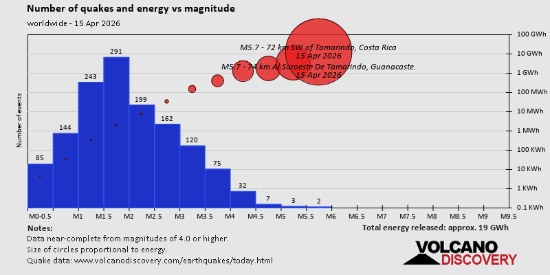 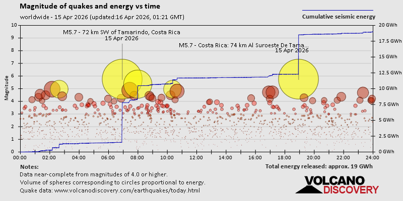 https://www.volcanodiscovery.com/earthquake/news/299988/World-Earthquake-Report-for-Wednesday-15-April-2026.html https://www.volcanodiscovery.com/earthquake/news/299988/World-Earthquake-Report-for-Wednesday-15-April-2026.html
0
15
Read More
|
Volcano earthquake report for Wednesday, 15 Apr 2026
Webmaster
Yesterday at 11:50 PM
Volcano earthquake report for Wednesday, 15 Apr 2026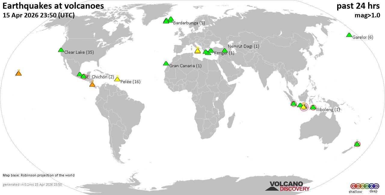 World map showing volcanoes with shallow (less than 50 km) earthquakes within 20 km radius during the past 24 hours on 15 Apr 2026 Number in brackets indicate nr of quakes. Quakes detected near: Baluran (3 quakes between mag 2.6-3.0), Bardarbunga (5 quakes between mag 0.0-1.2), Clear Lake (35 quakes between mag 0.2-1.8), El Chichón (2 quakes between mag 2.2-2.3), Etna (1 quake mag 1.2), Gareloi (6 quakes between mag 0.2-1.0)
Gran Canaria (1 quake mag 1.6), Hulubelu (4 quakes between mag 2.0-2.5), Iliboleng (1 quake mag 2.0), Kenger (1 quake mag 1.4), Kilauea (4 quakes between mag 1.4-1.9), Kolumbo (1 quake mag 1.8), Krísuvík (9 quakes between mag 0.0-1.4), Ljósufjöll (3 quakes between mag 0.9-1.9), Maunaloa (1 quake mag 1.6), Methana (1 quake mag 1.3), Muria (1 quake mag 2.4), Nemrut Dagi (1 quake mag 1.2), Pelée (16 quakes between mag 0.2-1.5), Pico de Orizaba (2 quakes between mag 2.0-2.1), Poas (2 quakes between mag 1.6-1.7), Raung (1 quake mag 2.6), Taupo (1 quake mag 2.4), Tjörnes Fracture Zone (6 quakes between mag 0.4-2.0), Vulcano (1 quake mag 1.8) (updated 23h50)
Note: Earthquakes within 20 km from and at depths less than 50 km under active volcanoes are reported. The list is not complete because many volcanoes are not monitored and/or seismic data in high resolution is not available publicly.
Volcanoes with recent earthquakes above magnitude 2 or more than 10 quakes are listed below:
Baluran volcano (East Java): 3 earthquakes up to magnitude 3.03 earthquakes occurred near (under) the volcano during 6 hours, the last being recorded quake 3 hours ago. Hypocenter depths ranged between 9.00 and 5.00 km. Earthquake details: 3.0 quake 16 km northwest of Wongsorejo, Kabupaten Banyuwangi, Jawa Timur, Indonesia, Apr 16, 2026 04:00 am (GMT +7) (9 km WSW) 2.6 quake Kabupaten Situbondo, 13 km north of Wongsorejo, Indonesia, Apr 15, 2026 09:49 pm (GMT +7) (4 km SSE) 2.6 quake Kabupaten Situbondo, 17 km north of Wongsorejo, Indonesia, Apr 15, 2026 10:04 pm (GMT +7) (2 km NE) All earthquakes at BaluranClear Lake volcano (California): 35 earthquakes up to magnitude 1.8Possible earthquake swarm: 35 earthquakes occurred near (under) the volcano during 22 hours, the last being recorded quake 2 hours ago. Hypocenter depths ranged between 12.55 and 0.43 km. Earthquake details: (only 5 largest) 1.8 quake Sonoma County, 13 mi southwest of Clearlake, Lake County, California, United States, Apr 14, 2026 08:51 pm (GMT -7) (15 km SSW) 1.7 quake 12 mi southwest of Clearlake, Lake County, California, United States, Apr 14, 2026 09:37 pm (GMT -7) (15 km S) 1.7 quake Sonoma County, 14 mi southwest of Clearlake, Lake County, California, United States, Apr 15, 2026 12:44 pm (GMT -7) (16 km SSW) 1.3 quake 27 mi north of Santa Rosa, Sonoma County, California, United States, Apr 15, 2026 02:36 pm (GMT -7) (17 km S) 1.3 quake 28 mi north of Santa Rosa, Sonoma County, California, United States, Apr 14, 2026 05:04 pm (GMT -7) (15 km SSW) All earthquakes at Clear LakeEl Chichón volcano (Southern Mexico): 2 earthquakes up to magnitude 2.32 earthquakes occurred near (under) the volcano during 7 hours, the last being recorded quake 17 hours ago. Hypocenter depths ranged between 3.00 and 3.00 km. Earthquake details: 2.3 quake Estado de Chiapas, 37 km southwest of Teapa, Estado de Tabasco, Mexico, Apr 14, 2026 05:50 pm (GMT -6) (1 km NNW) 2.2 quake Estado de Chiapas, 35 km southwest of Teapa, Estado de Tabasco, Mexico, Apr 15, 2026 12:53 am (GMT -6) (2 km E) All earthquakes at El ChichónHulubelu volcano (Sumatra): 4 earthquakes up to magnitude 2.54 earthquakes occurred near (under) the volcano during 13 hours, the last being recorded quake 8 hours ago. Hypocenter depths ranged between 20.00 and 3.00 km. Earthquake details: 2.5 quake Kabupaten Tanggamus, 73 km west of Bandar Lampung, Indonesia, Apr 15, 2026 02:11 pm (GMT +7) (4 km SE) 2.2 quake Kabupaten Tanggamus, 73 km west of Bandar Lampung, Indonesia, Apr 15, 2026 09:22 am (GMT +7) (8 km SSE) 2.0 quake Kabupaten Tanggamus, 76 km west of Bandar Lampung, Indonesia, Apr 15, 2026 10:41 pm (GMT +7) (8 km NNE) 2.0 quake Kabupaten Tanggamus, 85 km west of Bandar Lampung, Indonesia, Apr 15, 2026 10:16 am (GMT +7) (10 km WSW) All earthquakes at HulubeluMuria volcano (Central Java): magnitude 2.4 earthquakeA magnitude 2.4 earthquake occurred at the volcano 10 hours ago. The quake, which might be volcanic in origin, was located at a depth of 6.00 km depth at 10 km distance WSW from the volcano. Earthquake details: 2.4 quake 10.7 km northeast of Pecangaan, Indonesia, Apr 15, 2026 08:27 pm (GMT +7) (10 km WSW) All earthquakes at MuriaPelée volcano (Caribbean): 16 earthquakes up to magnitude 1.5Possible earthquake swarm: 16 earthquakes occurred near (under) the volcano during 19 hours, the last being recorded quake 4 hours ago. Hypocenter depths ranged between 0.38 and 0.00 km. Earthquake details: (only 5 largest) 1.5 quake 25 km northwest of Fort-de-France, Martinique, Apr 15, 2026 03:56 am (GMT -4) (1 km S) 1.1 quake 25 km northwest of Fort-de-France, Martinique, Apr 15, 2026 02:27 am (GMT -4) (1 km S) 0.9 quake 25 km northwest of Fort-de-France, Martinique, Apr 15, 2026 03:55 am (GMT -4) (1 km SSE) 0.8 quake 25 km northwest of Fort-de-France, Martinique, Apr 15, 2026 08:23 am (GMT -4) (1 km SSE) 0.8 quake 26 km northwest of Fort-de-France, Martinique, Apr 15, 2026 03:55 am (GMT -4) (1 km S) All earthquakes at PeléePico de Orizaba volcano (Western & Central Mexico): 2 earthquakes up to magnitude 2.12 earthquakes occurred near (under) the volcano during 5 minutes, the last being recorded quake 22 hours ago. Hypocenter depths ranged between 8.60 and 5.70 km. Earthquake details: 2.1 quake 25 km northwest of Orizaba, Estado de Veracruz-Llave, Mexico, Apr 14, 2026 08:18 pm (GMT -6) (3 km E) 2.0 quake 31 km northwest of Orizaba, Estado de Veracruz-Llave, Mexico, Apr 14, 2026 08:13 pm (GMT -6) (7 km NNE) All earthquakes at Pico de OrizabaRaung volcano (East Java): magnitude 2.6 earthquakeA magnitude 2.6 earthquake occurred at the volcano 10 hours ago. The quake, which might be volcanic in origin, was located at a depth of 8.00 km depth at 13 km distance NW from the volcano. Earthquake details: 2.6 quake 21 km southeast of Bondowoso, Kabupaten Bondowoso, Jawa Timur, Indonesia, Apr 15, 2026 08:46 pm (GMT +7) (13 km NW) All earthquakes at RaungTaupo volcano (New Zealand): magnitude 2.4 earthquakeA magnitude 2.4 earthquake occurred at the volcano 18 hours ago. The quake, which might be volcanic in origin, was located at a depth of 5.00 km depth at 19 km distance NNE from the volcano. Earthquake details: 2.4 quake 2.5 km north of Taupo, Waikato, New Zealand, Apr 15, 2026 05:41 pm (GMT +12) (19 km NNE) All earthquakes at Taupohttps://www.volcanodiscovery.com/earthquakes-volcanoes/news/299981/Volcano-earthquake-report-for-Wednesday-15-Apr-2026.html
0
4
Read More
|
Friday: Light Rain Showers, Minimum Temperature: 7°C (44°F) Maximum Temperature: 16°C (61°F)
Webmaster
Yesterday at 09:02 PM
Maximum Temperature: 16°C (61°F), Minimum Temperature: 7°C (44°F), Wind Direction: southerly, Wind Speed: 11mph, Visibility: Good, Pressure: 1015mb, Humidity: 77%, UV Risk: 3, Pollution: Low, Sunrise: 06:06 BST, Sunset: 20:13 BST Source: Friday: Light Rain Showers, Minimum Temperature: 7°C (44°F) Maximum Temperature: 16°C (61°F)
0
24
Read More
|
Thursday: Light Rain Showers, Minimum Temperature: 9°C (49°F) Maximum Temperature: 16°C (61°F)
Webmaster
Yesterday at 09:02 PM
Maximum Temperature: 16°C (61°F), Minimum Temperature: 9°C (49°F), Wind Direction: south-westerly, Wind Speed: 10mph, Visibility: Very Good, Pressure: 1015mb, Humidity: 61%, UV Risk: 3, Pollution: Low, Sunrise: 06:08 BST, Sunset: 20:11 BST Source: Thursday: Light Rain Showers, Minimum Temperature: 9°C (49°F) Maximum Temperature: 16°C (61°F)
0
24
Read More
|
|
Forums60
Topics769,107
Posts803,874
Members2,958
| |
Most Online17,963
Jan 15th, 2026
|
|
|
|
|
Copyright 1996 - 2026 by David Cottle. Designed by David Bate Jr. All Rights Reserved.
By using this forum, the user agrees not to transfer any data or technical information received under the agreement, to any other entity without the express approval of the AUS-CITY Forum Admins and/or authors of individual posts (Forum Admins and DoD/USSPACECOM for the analysis of satellite tracking data).
Two-line elements (TLE) and all other satellite data presented and distributed via this forum and e-mail lists of AUS-CITY are distributed with permission from DoD/USSTRATCOM.


Reprise Hosting

|

|


 - Click image for larger picture.")


