|
|
|
0 members (),
2,743
guests, and
25
robots. |
|
Key:
Admin,
Global Mod,
Mod
|
|
S |
M |
T |
W |
T |
F |
S |
|
|
1
|
2
|
3
|
4
|
5
|
6
|
|
7
|
8
|
9
|
10
|
11
|
12
|
13
|
|
14
|
15
|
16
|
17
|
18
|
19
|
20
|
|
21
|
22
|
23
|
24
|
25
|
26
|
27
|
|
28
|
29
|
30
|
|
|
|
|
|
There are no members with birthdays on this day. |
|
|
|
|
|
|
|
|
by Webmaster - Sat 06 Jun 2026 12:01:AM
|
by Webmaster - Sat 06 Jun 2026 12:01:AM
|
by Webmaster - Sat 06 Jun 2026 12:01:AM
|
|
|
SPC MD 991
by Webmaster - Sat 06 Jun 2026 12:00:AM
|
SPC MD 992
by Webmaster - Sat 06 Jun 2026 12:00:AM
|

Volcano earthquake report for Friday, 5 Jun 2026
• Small magnitude 3.1 earthquake 11 miles southwest of Pukatja, South Austral...
• Moderate mag. 4.2 earthquake - 40 km west of Matias Romero Avendano, Estado...
• World Earthquake Report for Friday, 5 June 2026
• Magnitude 3.8 earthquake strikes near Carlsbad, Eddy County, New Mexico, US...
• Moderate mag. 4.7 earthquake - North Pacific Ocean, 244 km southeast of Hac...
|
 SPC MD 991
Webmaster
3 hours ago
SPC MD 991
Webmaster
3 hours ago
SPC MD 991MD 0991 CONCERNING SEVERE THUNDERSTORM WATCH 274... FOR PARTS OF CENTRAL/NORTHERN WI AND SOUTHERN UPPER MI 
Mesoscale Discussion 0991
NWS Storm Prediction Center Norman OK
0524 PM CDT Fri Jun 05 2026

Areas affected...Parts of central/northern WI and southern Upper MI

Concerning...Severe Thunderstorm Watch 274...

Valid 052224Z - 060030Z

The severe weather threat for Severe Thunderstorm Watch 274
continues.

SUMMARY...A threat for locally damaging wind and isolated hail may
spread east-southeastward into the early evening.

DISCUSSION...A cluster of occasionally strong storms is ongoing at
2215 UTC across parts of northwest WI. MLCAPE of 1000-1500 J/kg and
effective shear of 30-35 kt are marginally supportive of organized
convection, though relatively weak midlevel lapse rates and
low-level flow have hindered potential for a more substantial severe
threat thus far. With time, expanding outflow within a steep
low-level lapse rate environment could support an increasing threat
for damaging wind as convection moves east-southeastward, and
isolated hail cannot be ruled out with the strongest embedded
updrafts.

An isolated severe threat will spread to the north and east of WW
274 into early evening. The need for a new watch is uncertain given
current trends, but these storms will be monitored for an uptick in
storm organization through 00 UTC.

..Dean/Gleason.. 06/05/2026

...Please see www.spc.noaa.gov for graphic product...

ATTN...WFO...MQT...GRB...MKX...DLH...ARX...MPX...

LAT...LON   46128990 46298865 46198805 46088782 45938764 45808757
            45438765 45238772 45148777 44638820 43888891 43718978
            43929106 44179168 44419196 44599232 44819138 45409040
            46128990

MOST PROBABLE PEAK WIND GUST...55-70 MPH
MOST PROBABLE PEAK HAIL SIZE...1.00-1.75 IN
Read morehttps://www.spc.noaa.gov/products/md/md0991.html
0
8
Read More
|
SPC MD 992
Webmaster
3 hours ago
SPC MD 992MD 0992 CONCERNING SEVERE THUNDERSTORM WATCH 275... FOR SOUTHERN NEBRASKA...NORTHERN KANSAS INTO WESTERN IOWA/MISSOURI 
Mesoscale Discussion 0992
NWS Storm Prediction Center Norman OK
0646 PM CDT Fri Jun 05 2026

Areas affected...southern Nebraska...northern Kansas into western
Iowa/Missouri

Concerning...Severe Thunderstorm Watch 275...

Valid 052346Z - 060115Z

The severe weather threat for Severe Thunderstorm Watch 275
continues.

SUMMARY...The severe risk continues across WW275. Additional storm
development is underway with an increasing risk for large hail
damaging winds.

DISCUSSION...As of 2340 UTC, evening visible and radar imagery
showed the initial convection at the confluence of the stationary
front and surface trough over far southern NE and northern KS had
dissipated. Additional convective towers were observed rapidly
deepening along the primary synoptic boundary and a more diffuse
secondary zone near the NE/KS border. A very unstable air mass is in
place with SPC mesoanalysis showing upwards of 4000 J/kg of MLCAPE.
This will support rapid thunderstorm development and
intensification, preferentially along these two corridors, this
evening.

Steep mid-level lapse rates and the large buoyancy should support a
risk for large hail (some 2+ inch) and damaging winds with a mixed
mode of supercells and multi cells. While background flow remains
fairly modest (OAX VAD) consolidating outflow should eventually
support the development of one or more eastward propagating clusters
with a risk for damaging winds and hail into parts of MO and IA.

..Lyons.. 06/05/2026

...Please see www.spc.noaa.gov for graphic product...

ATTN...WFO...DMX...EAX...OAX...TOP...GID...

LAT...LON   39719941 40599938 41479846 41659692 41669567 41189480
            40619470 40239470 39899504 39819569 39749696 39689817
            39689892 39719941

MOST PROBABLE PEAK TORNADO INTENSITY...UP TO 90 MPH
MOST PROBABLE PEAK WIND GUST...65-80 MPH
MOST PROBABLE PEAK HAIL SIZE...1.50-2.50 IN
Read morehttps://www.spc.noaa.gov/products/md/md0992.html
0
7
Read More
|
SPC Severe Thunderstorm Watch 274 Status Reports
Webmaster
3 hours ago
SPC Severe Thunderstorm Watch 274 Status ReportsWW 0274 Status Updates 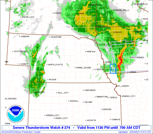
STATUS REPORT ON WW 274

SEVERE WEATHER THREAT CONTINUES RIGHT OF A LINE FROM 10 NNE VVV
TO 20 NNE STC TO 50 NE MSP TO 20 WNW EAU TO 15 ENE EAU TO 45 WNW
AUW TO 15 W RHI.

FOR ADDITIONAL INFORMATION SEE MESOSCALE DISCUSSION 0991

..DEAN..06/05/26

ATTN...WFO...MPX...ARX...


STATUS REPORT FOR WS 274

SEVERE WEATHER THREAT CONTINUES FOR THE FOLLOWING AREAS

MNC003-013-015-019-023-025-037-039-049-053-059-067-073-079-085-
093-103-109-123-127-129-131-139-141-143-145-147-151-157-161-163-
165-169-171-173-060040-

MN
.    MINNESOTA COUNTIES INCLUDED ARE

ANOKA                BLUE EARTH          BROWN
CARVER               CHIPPEWA            CHISAGO
DAKOTA               DODGE               GOODHUE
HENNEPIN             ISANTI              KANDIYOHI
LAC QUI PARLE        LE SUEUR            MCLEOD
MEEKER               NICOLLET            OLMSTED
RAMSEY               REDWOOD             RENVILLE
RICE                 SCOTT               SHERBURNE
SIBLEY               STEARNS             STEELE
SWIFT                WABASHA             WASECA
WASHINGTON           WATONWAN            WINONA
WRIGHT               YELLOW MEDICINE


WIC011-017-019-033-035-053-063-081-091-093-109-119-121-060040-
Read morehttps://www.spc.noaa.gov/products/watch/ws0274.html
0
6
Read More
|
SPC Severe Thunderstorm Watch 274
Webmaster
3 hours ago
SPC Severe Thunderstorm Watch 274WW 274 SEVERE TSTM MN WI 052025Z - 060400Z
URGENT - IMMEDIATE BROADCAST REQUESTED
Severe Thunderstorm Watch Number 274
NWS Storm Prediction Center Norman OK
325 PM CDT Fri Jun 5 2026

The NWS Storm Prediction Center has issued a

* Severe Thunderstorm Watch for portions of
  Central and Southern Minnesota
  West-Central Wisconsin

* Effective this Friday afternoon and evening from 325 PM until
  1100 PM CDT.

* Primary threats include...
  Scattered damaging wind gusts to 65 mph possible
  Scattered large hail events to 1.5 inches in diameter possible

SUMMARY...Scattered thunderstorms are currently ongoing across
west-central Minnesota and northwest Wisconsin this afternoon. These
storms will likely continue eastward/southeastward throughout the
afternoon, posing a threat for large hail and damaging gusts from
central/southern Minnesota and west-central Wisconsin.

The severe thunderstorm watch area is approximately along and 55
statute miles north and south of a line from 55 miles northwest of
Redwood Falls MN to 30 miles north of Camp Douglas WI. For a
complete depiction of the watch see the associated watch outline
update (WOUS64 KWNS WOU4).

PRECAUTIONARY/PREPAREDNESS ACTIONS...

REMEMBER...A Severe Thunderstorm Watch means conditions are
favorable for severe thunderstorms in and close to the watch area.
Persons in these areas should be on the lookout for threatening
weather conditions and listen for later statements and possible
warnings. Severe thunderstorms can and occasionally do produce
tornadoes.

&&

AVIATION...A few severe thunderstorms with hail surface and aloft to
1.5 inches. Extreme turbulence and surface wind gusts to 55 knots. A
few cumulonimbi with maximum tops to 500. Mean storm motion vector
30025.

...Mosier
Read morehttps://www.spc.noaa.gov/products/watch/ww0274.html
0
1
Read More
|
SPC Severe Thunderstorm Watch 275
Webmaster
3 hours ago
SPC Severe Thunderstorm Watch 275WW 275 SEVERE TSTM IA KS MO NE 052245Z - 060500Z 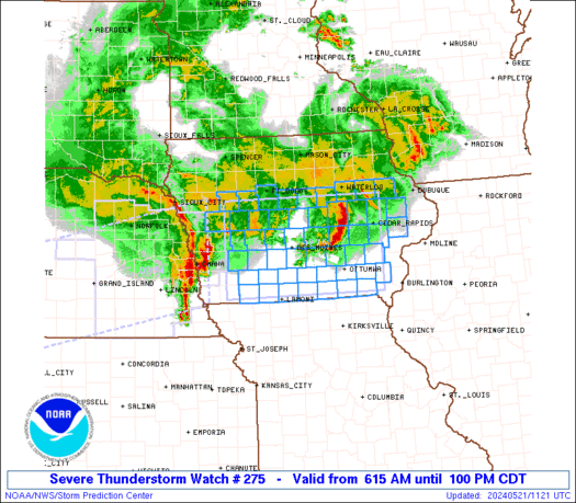
URGENT - IMMEDIATE BROADCAST REQUESTED
Severe Thunderstorm Watch Number 275
NWS Storm Prediction Center Norman OK
545 PM CDT Fri Jun 5 2026

The NWS Storm Prediction Center has issued a

* Severe Thunderstorm Watch for portions of
  Southwest Iowa
  North-Central and Northeast Kansas
  Northwest Missouri
  Southern and Eastern Nebraska

* Effective this Friday afternoon from 545 PM until Midnight CDT.

* Primary threats include...
  Scattered damaging winds and isolated significant gusts to 75
    mph possible
  Scattered large hail and isolated very large hail events to 2
    inches in diameter possible
  A tornado or two possible

SUMMARY...Thunderstorms should continue to develop this evening
along/near the Kansas/Nebraska border. The strongest thunderstorms
should pose a threat for large to very large hail (up to 2 inches in
diameter) and severe/damaging winds (up to 65-75 mph). A tornado or
two is also possible along/near a stationary front.

The severe thunderstorm watch area is approximately along and 55
statute miles north and south of a line from 30 miles southwest of
Hastings NE to 30 miles east of Shenandoah IA. For a complete
depiction of the watch see the associated watch outline update
(WOUS64 KWNS WOU5).

PRECAUTIONARY/PREPAREDNESS ACTIONS...

REMEMBER...A Severe Thunderstorm Watch means conditions are
favorable for severe thunderstorms in and close to the watch area.
Persons in these areas should be on the lookout for threatening
weather conditions and listen for later statements and possible
warnings. Severe thunderstorms can and occasionally do produce
tornadoes.

&&

OTHER WATCH INFORMATION...CONTINUE...WW 274...

AVIATION...A few severe thunderstorms with hail surface and aloft to
2 inches. Extreme turbulence and surface wind gusts to 65 knots. A
few cumulonimbi with maximum tops to 500. Mean storm motion vector
27020.

...Gleason
Read morehttps://www.spc.noaa.gov/products/watch/ww0275.html
0
2
Read More
|
Volcano earthquake report for Friday, 5 Jun 2026
Webmaster
Yesterday at 11:50 PM
Volcano earthquake report for Friday, 5 Jun 2026World map showing volcanoes with shallow (less than 50 km) earthquakes within 20 km radius during the past 24 hours on 5 Jun 2026 Number in brackets indicate nr of quakes. Quakes detected near: Askja (3 quakes between mag 0.7-1.0), Bardarbunga (6 quakes between mag 0.0-1.0), Brennisteinsfjöll (9 quakes between mag 0.0-1.4), Cabalian (1 quake mag 1.8), Cerro Negro de Mayasquer (1 quake mag 2.9), Chaîne des Puys (2 quakes between mag 1.0-1.5)
Clear Lake (52 quakes between mag 0.2-1.8), Cleveland (3 quakes between mag 0.8-1.2), Colima (1 quake mag 3.2), Conchagüita (3 quakes between mag 2.3-2.7), Eldey (3 quakes between mag 0.6-1.5), Esjufjöll (2 quakes between mag 0.5-1.1), Gareloi (1 quake mag 1.3), Geureudong (1 quake mag 2.1), Hengill (3 quakes between mag 0.1-1.7), Hrómundartindur (8 quakes between mag 0.1-1.1), Hulubelu (2 quakes between mag 2.0-2.0), Iriga (1 quake mag 3.1), Kenger (1 quake mag 1.4), Kilauea (3 quakes between mag 1.9-2.8), Kolumbo (1 quake mag 1.9), Krísuvík (5 quakes between mag 0.0-1.2), Kupreanof (3 quakes between mag 1.1-2.5), Kverkfjöll (1 quake mag 1.4), Langjökull (1 quake mag 1.3), Mammoth Mountain (2 quakes between mag 0.9-1.6), Masaya (1 quake mag 2.0), Maunaloa (3 quakes between mag 1.8-2.2), Mayon (2 quakes between mag 3.1-4.1), Mayotte Island (2 quakes between mag 0.6-1.9), Moffett (5 quakes between mag 0.8-2.5), Nejapa-Miraflores (1 quake mag 3.0), Pocdol Mountains (2 quakes between mag 3.0-5.3), Prestahnukur (113 quakes between mag 0.0-2.8), Reporoa (1 quake mag 1.8), San Salvador (1 quake mag 3.0), Sorikmarapi (2 quakes between mag 2.9-3.9), Soufrière de Guadeloupe (1 quake mag 3.0), Stepovak Bay 4 (1 quake mag 1.9), Süphan Dağ (1 quake mag 1.1), Tambora (1 quake mag 2.0), Tana (4 quakes between mag 0.3-2.1), Taupo (2 quakes between mag 2.0-2.0), Tenerife (5 quakes between mag 0.4-1.3), Tenorio (1 quake mag 1.0), Theistareykjarbunga (1 quake mag 1.4), Thordarhyrna (4 quakes between mag 0.0-1.3) (updated 23h50)
Note: Earthquakes within 20 km from and at depths less than 50 km under active volcanoes are reported. The list is not complete because many volcanoes are not monitored and/or seismic data in high resolution is not available publicly.
Volcanoes with recent earthquakes above magnitude 2 or more than 10 quakes are listed below:
Cerro Negro de Mayasquer volcano (Colombia): magnitude 2.9 earthquakeA magnitude 2.9 earthquake occurred at the volcano 7 hours ago. The quake, which might be volcanic in origin, was located at a depth of 8.00 km depth at 12 km distance E from the volcano. Earthquake details: 2.9 quake 24 km west of Ipiales, Departamento de Narino, Colombia, Jun 5, 2026 11:56 am (GMT -5) (12 km E) All earthquakes at Cerro Negro de MayasquerClear Lake volcano (California): 52 earthquakes up to magnitude 1.8Possible earthquake swarm: 52 earthquakes occurred near (under) the volcano during 21 hours, the last being recorded quake 11 minutes ago. Hypocenter depths ranged between 14.49 and 0.13 km. Earthquake details: (only 5 largest) 1.8 quake Sonoma County, 14 mi southwest of Clearlake, Lake County, California, United States, Jun 4, 2026 07:59 pm (GMT -7) (15 km SSW) 1.7 quake Sonoma County, 13 mi southwest of Clearlake, Lake County, California, United States, Jun 5, 2026 08:20 am (GMT -7) (15 km SSW) 1.6 quake Sonoma County, 13 mi southwest of Clearlake, Lake County, California, United States, Jun 5, 2026 10:14 am (GMT -7) (17 km S) 1.4 quake 25 mi north of Santa Rosa, Sonoma County, California, United States, Jun 5, 2026 04:55 am (GMT -7) (19 km S) 1.4 quake 26 mi north of Santa Rosa, Sonoma County, California, United States, Jun 5, 2026 01:01 am (GMT -7) (18 km S) All earthquakes at Clear LakeColima volcano (Western & Central Mexico): magnitude 3.2 earthquakeA magnitude 3.2 earthquake occurred at the volcano 16 hours ago. The quake, which might be volcanic in origin, was located at a depth of 9.90 km depth at 3 km distance NE from the volcano. Earthquake details: 3.2 quake 24 km southwest of Ciudad Guzman, Estado de Jalisco, Mexico, Jun 5, 2026 01:24 am (GMT -6) (3 km NE) All earthquakes at ColimaConchagüita volcano (El Salvador): 3 earthquakes up to magnitude 2.73 earthquakes occurred near (under) the volcano during 1 hour 33 minutes, the last being recorded quake 17 hours ago. Hypocenter depths ranged between 7.00 and 4.00 km. Earthquake details: 2.7 quake North Pacific Ocean, 10.1 km southeast of La Union, El Salvador, Jun 5, 2026 12:38 am (GMT -6) (6 km N) 2.5 quake North Pacific Ocean, 11 km southeast of La Union, El Salvador, Jun 4, 2026 11:39 pm (GMT -6) (6 km N) 2.3 quake North Pacific Ocean, 10.5 km southeast of La Union, El Salvador, Jun 5, 2026 01:12 am (GMT -6) (6 km N) All earthquakes at ConchagüitaGeureudong volcano (Sumatra): magnitude 2.1 earthquakeA magnitude 2.1 earthquake occurred at the volcano 20 hours ago. The quake, which might be volcanic in origin, was located at a depth of 11.00 km depth at 6 km distance W from the volcano. Earthquake details: 2.1 quake Kabupaten Bener Meriah, 50 km south of Bireun, Indonesia, Jun 5, 2026 10:41 am (GMT +7) (6 km W) All earthquakes at GeureudongIriga volcano (Luzon Island): magnitude 3.1 earthquakeA magnitude 3.1 earthquake occurred at the volcano 10 hours ago. The quake, which might be volcanic in origin, was located at a depth of 1.00 km depth at 7 km distance ESE from the volcano. Earthquake details: 3.1 quake Philippine Sea, 10.2 km southwest of Batan Island, Philippines, Jun 5, 2026 10:09 pm (GMT +8) (7 km ESE) All earthquakes at IrigaKilauea volcano (Hawai'i (Big Island)): 3 earthquakes up to magnitude 2.83 earthquakes occurred near (under) the volcano during 18 hours, the last being recorded quake 5 hours ago. Hypocenter depths ranged between 31.12 and 1.61 km. Earthquake details: 2.8 quake 27 mi south of Hilo, Hawaii County, Hawaii, United States, Jun 4, 2026 07:28 pm (GMT -10) (19 km ESE) 2.3 quake 36 mi southwest of Hilo, Hawaii County, Hawaii, United States, Jun 5, 2026 08:26 am (GMT -10) (17 km SW) 1.9 quake 28 mi south of Hilo, Hawaii County, Hawaii, United States, Jun 4, 2026 02:35 pm (GMT -10) (12 km SE) All earthquakes at KilaueaKupreanof volcano (Alaska Peninsula): 3 earthquakes up to magnitude 2.53 earthquakes occurred near (under) the volcano during 8 hours, the last being recorded quake 13 hours ago. Hypocenter depths ranged between 9.02 and 6.40 km. Earthquake details: 2.5 quake Lake and Peninsula Borough, 53 mi northeast of Sand Point, Aleutians East Borough, Alaska, United States, Jun 5, 2026 02:59 am (GMT -8) (4 km SSE) 1.9 quake 51 mi northeast of Sand Point, Aleutians East Borough, Alaska, United States, Jun 4, 2026 06:49 pm (GMT -8) (5 km SW) 1.1 quake Lake and Peninsula Borough, 56 mi northeast of Sand Point, Aleutians East Borough, Alaska, United States, Jun 5, 2026 08:17 am (Universal Time) (6 km E) All earthquakes at KupreanofMaunaloa volcano (Hawai'i (Big Island)): 3 earthquakes up to magnitude 2.23 earthquakes occurred near (under) the volcano during 2 hours, the last being recorded quake 14 hours ago. Hypocenter depths ranged between 9.39 and 3.76 km. Earthquake details: 2.2 quake 33 mi southwest of Hilo, Hawaii County, Hawaii, United States, Jun 4, 2026 09:48 pm (GMT -10) (15 km ESE) 2.1 quake 18 mi west of Volcano, Hawaii County, Hawaii, United States, Jun 4, 2026 10:28 pm (GMT -10) (13 km SE) 1.8 quake 32 mi southwest of Hilo, Hawaii County, Hawaii, United States, Jun 5, 2026 12:13 am (GMT -10) (11 km E) All earthquakes at MaunaloaMayon volcano (Luzon Island): 2 earthquakes up to magnitude 4.12 earthquakes occurred near (under) the volcano during 47 minutes, the last being recorded quake 12 hours ago. Hypocenter depths ranged between 15.00 and 12.00 km. Earthquake details: 4.1 quake 15 km northeast of Legaspi, Province of Albay, Bicol, Philippines, Jun 5, 2026 07:22 pm (Manila time) (16 km E) 3.1 quake 15 km northeast of Legaspi, Province of Albay, Bicol, Philippines, Jun 5, 2026 08:09 pm (GMT +8) (15 km E) All earthquakes at MayonMoffett volcano (Aleutian Islands): 5 earthquakes up to magnitude 2.55 earthquakes occurred near (under) the volcano during 13 hours, the last being recorded quake 7 hours ago. Hypocenter depths ranged between 16.30 and 4.60 km. Earthquake details: 2.5 quake Bering Sea, 5.2 mi northeast of Adak Island, Aleutians West Census Area, Alaska, United States, Jun 5, 2026 08:15 am (GMT -9) (16 km SE) 2.3 quake Bering Sea, 6 mi northeast of Adak Island, Aleutians West Census Area, Alaska, United States, Jun 5, 2026 07:40 am (GMT -9) (15 km SE) 1.8 quake Bering Sea, 6.3 mi northeast of Adak Island, Aleutians West Census Area, Alaska, United States, Jun 5, 2026 01:14 am (GMT -9) (15 km SE) 1.5 quake Bering Sea, 6.9 mi northeast of Adak Island, Aleutians West Census Area, Alaska, United States, Jun 5, 2026 04:17 am (GMT -9) (14 km ESE) 0.8 quake Bering Sea, 5 mi north of Adak Island, Aleutians West Census Area, Alaska, United States, Jun 5, 2026 03:54 am (Universal Time) (13 km SE) All earthquakes at MoffettNejapa-Miraflores volcano (Nicaragua): magnitude 3.0 earthquakeA magnitude 3.0 earthquake occurred at the volcano 20 hours ago. The quake, which might be volcanic in origin, was located at a depth of 10.00 km depth at 5 km distance SSW from the volcano. Earthquake details: Reported seismic-like event (likely no quake): 12 km southwest of Managua, Departamento de Managua, Nicaragua, Jun 4, 2026 09:43 pm (GMT -6) (5 km SSW) All earthquakes at Nejapa-MirafloresPocdol Mountains volcano (Luzon Island): 2 earthquakes up to magnitude 5.32 earthquakes occurred near (under) the volcano during 3 hours, the last being recorded quake 7 hours ago. Hypocenter depths ranged between 10.00 and 1.00 km. Earthquake details: 5.3 quake 28 km northwest of Sorsogon, Province of Sorsogon, Bicol, Philippines, Jun 5, 2026 09:57 pm (Manila time) (19 km NW) 3.0 quake Philippine Sea, 10.6 km southwest of Batan Island, Philippines, Jun 6, 2026 12:54 am (GMT +8) (13 km N) All earthquakes at Pocdol MountainsPrestahnukur volcano (Iceland): 113 earthquakes up to magnitude 2.8Possible earthquake swarm: 113 earthquakes occurred near (under) the volcano during 23 hours, the last being recorded quake 36 minutes ago. Hypocenter depths ranged between 20.40 and 0.00 km. Earthquake details: (only 5 largest) 2.8 quake West, 71 km northeast of Reykjavik, Capital Region, Iceland, Jun 5, 2026 07:06 pm (Reykjavik time) (12 km WSW) 2.0 quake 16.2 km N of Skjaldbreið Jun 5, 2026 05:00 pm (Universal Time) (12 km WSW) 2.0 quake 11.5 km SSE of Húsafell Jun 5, 2026 08:04 am (Universal Time) (10 km W) 1.9 quake 15.3 km N of Skjaldbreið Jun 5, 2026 09:53 pm (Universal Time) (13 km WSW) 1.9 quake Iceland: 15.8 km SSE of Húsafell Jun 5, 2026 07:25 pm (Reykjavik time) (12 km WSW) All earthquakes at PrestahnukurSan Salvador volcano (El Salvador): magnitude 3.0 earthquakeA magnitude 3.0 earthquake occurred at the volcano 6 hours ago. The quake, which might be volcanic in origin, was located at a depth of 10.00 km depth at 6 km distance S from the volcano. Earthquake details: Reported seismic-like event (likely no quake): 10.6 km west of San Salvador, Departamento de San Salvador, El Salvador, Jun 5, 2026 12:03 pm (GMT -6) (6 km S) All earthquakes at San SalvadorSorikmarapi volcano (Sumatra): 2 earthquakes up to magnitude 3.92 earthquakes occurred near (under) the volcano during 62 seconds, the last being recorded quake 2 hours ago. Hypocenter depths ranged between 10.00 and 4.00 km. Earthquake details: 3.9 quake Kabupaten Mandailing Natal, North Sumatra, 128 km northwest of Bukittinggi, Indonesia, Jun 6, 2026 04:35 am (Jakarta time) (16 km SE) 2.9 quake Kabupaten Mandailing Natal, 99 km south of Padangsidempuan, Indonesia, Jun 6, 2026 04:34 am (GMT +7) (16 km S) All earthquakes at SorikmarapiSoufrière de Guadeloupe volcano (Caribbean): magnitude 3.0 earthquakeA magnitude 3.0 earthquake occurred at the volcano 17 hours ago. The quake, which might be volcanic in origin, was located at a depth of 10.00 km depth at 19 km distance N from the volcano. Earthquake details: Reported seismic-like event (likely no quake): 17 km west of Les Abymes, Guadeloupe, Jun 5, 2026 02:59 am (GMT -4) (19 km N) All earthquakes at Soufrière de GuadeloupeTana volcano (Aleutian Islands): 4 earthquakes up to magnitude 2.14 earthquakes occurred near (under) the volcano during 6 hours, the last being recorded quake 18 hours ago. Hypocenter depths ranged between 5.04 and 0.49 km. Earthquake details: 2.1 quake 38 mi west of Nikolski, Aleutians West Census Area, Alaska, United States, Jun 4, 2026 02:57 pm (GMT -9) (4 km N) 1.4 quake 41 mi west of Nikolski, Aleutians West Census Area, Alaska, United States, Jun 4, 2026 09:08 pm (GMT -9) (6 km NW) 1.1 quake 41 mi west of Nikolski, Aleutians West Census Area, Alaska, United States, Jun 5, 2026 12:36 am (Universal Time) (5 km WNW) 0.3 quake 41 mi west of Nikolski, Aleutians West Census Area, Alaska, United States, Jun 5, 2026 12:37 am (Universal Time) (5 km WNW) All earthquakes at Tanahttps://www.volcanodiscovery.com/earthquakes-volcanoes/news/304198/Volcano-earthquake-report-for-Friday-5-Jun-2026.html
0
4
Read More
|
Small magnitude 3.1 earthquake 11 miles southwest of Pukatja, South Australia, Australia
Webmaster
Yesterday at 11:37 PM
Small magnitude 3.1 earthquake 11 miles southwest of Pukatja, South Australia, Australia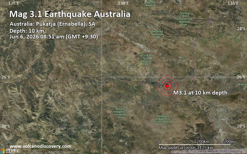 An earthquake of magnitude 3.1 occurred in the morning on Saturday, June 6th, 2026, at 8:21 am local time near Pukatja, Anangu Pitjantjatjara, South Australia, Australia, as reported by Geoscience Australia (GeoAu).
According to preliminary data, the quake was located at a shallow depth of 6.2 miles. Shallow earthquakes are felt more strongly than deeper ones as they are closer to the surface. The exact magnitude, epicenter, and depth of the quake might be revised within the next few hours or minutes as seismologists review data and refine their calculations, or as other agencies issue their report.
A second report was later issued by the European-Mediterranean Seismological Centre (EMSC), which listed it as a magnitude 3.1 earthquake as well. A third agency, the citizen-seismograph network of RaspberryShake, reported the same quake at magnitude 3.1.
Towns or cities near the epicenter where the quake might have been felt as very weak shaking include Pukatja (pop. 510) located 11 miles from the epicenter.
Earthquake data: Date & time: Jun 6, 2026 08:51 am (GMT +9:30) local time (5 Jun 2026 23:21 GMT)Magnitude: 3.1 Depth: 10.00 km Epicenter latitude / longitude: 26.37°S / 131.99°E  ( Anangu Pitjantjatjara, South Australia, Australia) Primary data source: GeoAuhttps://www.volcanodiscovery.com/earthquake/news/304304/Small-magnitude-31-earthquake-11-miles-southwest-of-Pukatja-South-Australia-Australia.html
0
2
Read More
|
World Earthquake Report for Friday, 5 June 2026
Webmaster
Yesterday at 11:20 PM
World Earthquake Report for Friday, 5 June 2026 Worldwide earthquakes above magnitude 3 during the past 24 hours on 5 Jun 2026 Magnitude 5+: 10 earthquakes Magnitude 4+: 34 earthquakes Magnitude 3+: 151 earthquakes Magnitude 2+: 322 earthquakes No quakes of magnitude 6 or higher 10 largest earthquakes in the world (past 24 hours)Saturday, Jun 6, 2026, at 07:58 am (GMT +11) - Friday, Jun 5, 2026, at 04:40 am (GMT -9) - Friday, Jun 5, 2026, at 09:57 pm (Manila time) - Saturday, Jun 6, 2026, at 12:57 am (Jayapura time) - Friday, Jun 5, 2026, at 07:28 am (GMT +8) - Friday, Jun 5, 2026, at 10:06 pm (Kolkata time) - Friday, Jun 5, 2026, at 03:54 am (San Luis time) - Friday, Jun 5, 2026, at 02:55 pm (Mexico City time) - Saturday, Jun 6, 2026, at 08:01 am (GMT +10) - Saturday, Jun 6, 2026, at 10:22 am (GMT +12) - Earthquakes reported feltFriday, Jun 5, 2026, at 10:04 pm (Kolkata time) - Friday, Jun 5, 2026, at 09:57 pm (Manila time) - Friday, Jun 5, 2026, at 02:55 pm (Mexico City time) - Thursday, Jun 4, 2026, at 07:41 pm (Caracas time) - Friday, Jun 5, 2026, at 06:27 am (GMT -6) - Friday, Jun 5, 2026, at 08:52 am (Kolkata time) - Friday, Jun 5, 2026, at 03:54 am (San Luis time) - Friday, Jun 5, 2026, at 11:52 pm (Kolkata time) - Friday, Jun 5, 2026, at 07:28 am (GMT +8) - Saturday, Jun 6, 2026, at 12:57 am (Jayapura time) - Friday, Jun 5, 2026, at 08:00 pm (GMT +11) - Friday, Jun 5, 2026, at 10:06 pm (Kolkata time) - Friday, Jun 5, 2026, at 07:22 pm (Manila time) - Saturday, Jun 6, 2026, at 06:26 am (GMT +10) - Friday, Jun 5, 2026, at 03:10 am (GMT +3) - Friday, Jun 5, 2026, at 11:03 pm (Kolkata time) - Friday, Jun 5, 2026, at 01:35 pm (GMT +7) - Friday, Jun 5, 2026, at 09:39 am (Santiago time) - Friday, Jun 5, 2026, at 06:36 am (GMT +7) - Thursday, Jun 4, 2026, at 11:16 pm (Mazatlan time) - Earthquake stats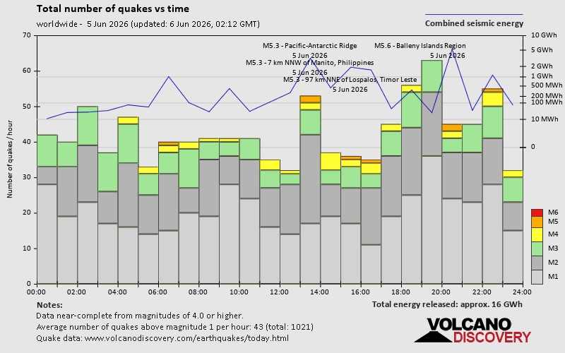 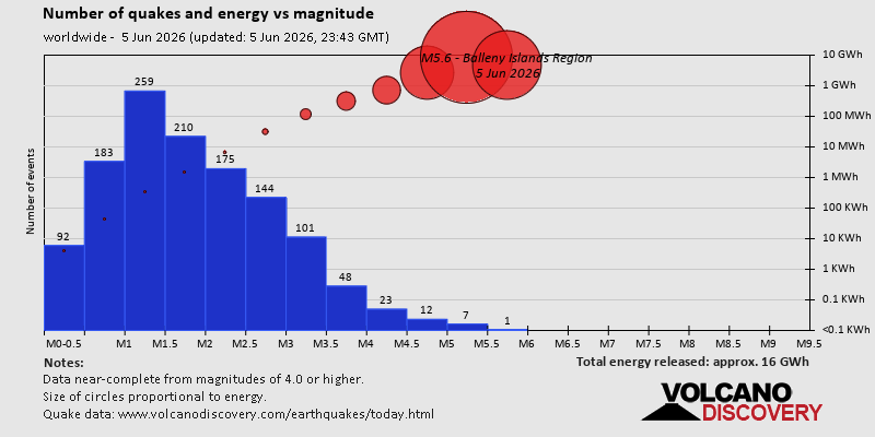 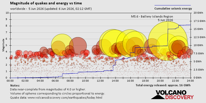 https://www.volcanodiscovery.com/earthquake/news/304203/World-Earthquake-Report-for-Friday-5-June-2026.html https://www.volcanodiscovery.com/earthquake/news/304203/World-Earthquake-Report-for-Friday-5-June-2026.html
0
2
Read More
|
Eastern North Pacific Tropical Weather Outlook
Webmaster
Yesterday at 11:17 PM
000 ABPZ20 KNHC 052316 TWOEP Tropical Weather Outlook NWS National Hurricane Center Miami FL 500 PM PDT Fri Jun 5 2026 For the eastern and central North Pacific east of 180 longitude: Active Systems: The National Hurricane Center is issuing advisories on Tropical Storm Amanda, located well west-southwest of the southern tip of the Baja California Peninsula. Offshore Southern and Southwestern Mexico (EP91): A broad area of low pressure located a few hundred miles southwest of Zihuatanejo, Mexico, is producing a large area of showers and thunderstorms. Environmental conditions appear conducive for development of this system, and a tropical depression is likely to form late this weekend or early next week. The disturbance is forecast to move northeastward and then northward near the coast of southern Mexico during the next few days. Interests in southern Mexico should monitor the progress of this system. Regardless of development, locally heavy rainfall is possible across portions of southern Mexico through early next week. * Formation chance through 48 hours...medium...60 percent. * Formation chance through 7 days...high...70 percent. Offshore of Central America: Disorganized showers and thunderstorms located offshore of Central America are associated with a trough of low pressure. Environmental conditions appear conducive for gradual development of this system while it moves slowly northward toward the coast of Central America, and a tropical depression could form later this weekend or early next week if the system remains offshore. Regardless of development, locally heavy rainfall is possible across portions of Costa Rica, Nicaragua, El Salvador, and Guatemala through early next week. * Formation chance through 48 hours...medium...40 percent. * Formation chance through 7 days...medium...60 percent. $$ Forecaster Reinhart Source: Eastern North Pacific Tropical Weather Outlook
0
4
Read More
|
|
Forums60
Topics779,054
Posts813,849
Members2,960
| |
Most Online22,463
May 9th, 2026
|
|
|
|
|
Copyright 1996 - 2026 by David Cottle. Designed by David Bate Jr. All Rights Reserved.
By using this forum, the user agrees not to transfer any data or technical information received under this agreement to any other entity without the express approval of the AUS-CITY Forum Admins and/or authors of individual posts (Forum Admins and DoD/USSPACECOM for the analysis of satellite tracking data).
Two-line elements (TLE) and all other satellite data presented and distributed via this forum and AUS-CITY mailing lists are distributed with permission from DoD/USSTRATCOM.


|

|


 - Click image for larger picture.")


