|
|
|
0 members (),
1,777
guests, and
25
robots. |
|
Key:
Admin,
Global Mod,
Mod
|
|
S |
M |
T |
W |
T |
F |
S |
|
1
|
2
|
3
|
4
|
5
|
6
|
7
|
|
8
|
9
|
10
|
11
|
12
|
13
|
14
|
|
15
|
16
|
17
|
18
|
19
|
20
|
21
|
|
22
|
23
|
24
|
25
|
26
|
27
|
28
|
|
29
|
30
|
31
|
|
|
|
|
|
There are no members with birthdays on this day. |
 World Earthquake Report for Wednesday, 25 March 2026
Webmaster
4 hours ago
World Earthquake Report for Wednesday, 25 March 2026
Webmaster
4 hours ago
World Earthquake Report for Wednesday, 25 March 2026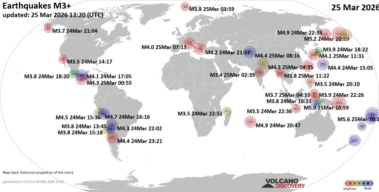 Worldwide earthquakes above magnitude 3 during the past 24 hours on 25 Mar 2026 Magnitude 5+: 4 earthquakes Magnitude 4+: 31 earthquakes Magnitude 3+: 129 earthquakes Magnitude 2+: 322 earthquakes No quakes of magnitude 6 or higher 10 largest earthquakes in the world (past 24 hours)Wednesday, Mar 25, 2026, at 11:10 pm (GMT +13) - Wednesday, Mar 25, 2026, at 11:17 pm (GMT +13) - Tuesday, Mar 24, 2026, at 10:59 am (GMT -10) - Wednesday, Mar 25, 2026, at 08:59 pm (GMT +10) - Wednesday, Mar 25, 2026, at 09:35 am (GMT +11) - Wednesday, Mar 25, 2026, at 03:24 pm (GMT +13) - Wednesday, Mar 25, 2026, at 01:47 am (GMT +5) - Wednesday, Mar 25, 2026, at 01:47 pm (GMT +5) - Tuesday, Mar 24, 2026, at 11:16 am (GMT -5) - Wednesday, Mar 25, 2026, at 11:48 pm (GMT +12) - Earthquakes reported feltWednesday, Mar 25, 2026, at 08:13 am (GMT +1) - Wednesday, Mar 25, 2026, at 08:31 pm (GMT +9) - Tuesday, Mar 24, 2026, at 11:57 pm (GMT +2) - Tuesday, Mar 24, 2026, at 08:21 pm (GMT -3) - Wednesday, Mar 25, 2026, at 08:33 pm (GMT +9) - Wednesday, Mar 25, 2026, at 12:05 pm (GMT +1) - Wednesday, Mar 25, 2026, at 10:03 am (GMT +1) - Tuesday, Mar 24, 2026, at 12:46 pm (GMT -5) - Tuesday, Mar 24, 2026, at 11:55 pm (GMT +2) - Wednesday, Mar 25, 2026, at 01:34 pm (GMT +2) - Wednesday, Mar 25, 2026, at 09:55 am (GMT +5:30) - Tuesday, Mar 24, 2026, at 10:16 pm (Universal Time) - Wednesday, Mar 25, 2026, at 07:27 am (GMT -3) - Earthquake stats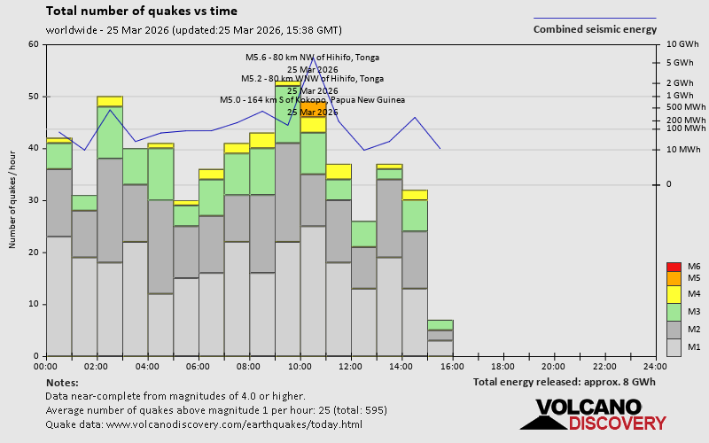 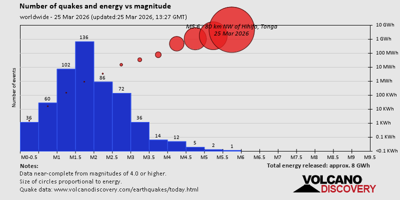 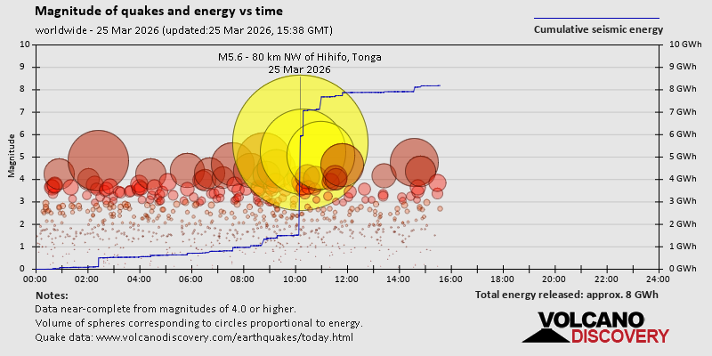 https://www.volcanodiscovery.com/earthquake/news/298505/World-Earthquake-Report-for-Wednesday-25-March-2026.html https://www.volcanodiscovery.com/earthquake/news/298505/World-Earthquake-Report-for-Wednesday-25-March-2026.html
0
14
Read More
|
Seismic-like event, possible earthquake, reported few minutes ago Antofagasta, Chile
Webmaster
4 hours ago
Seismic-like event, possible earthquake, reported few minutes ago Antofagasta, Chile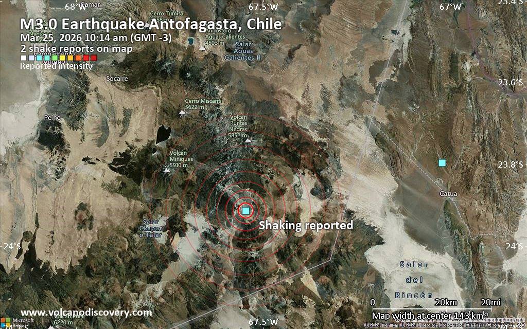 Unconfirmed quake or seismic-like event reported: 129 km west of San Antonio de los Cobres, Departamento de Los Andes, Salta Province, Argentina, 4 minutes ago We are receiving unverified early reports of ground shaking possibly caused by seismic activity in or near Antofagasta, Chile on 25 Mar 2026 (GMT) at approximately 13:14 GMT.
There are no details yet on the magnitude or depth of this possible quake. If confirmed, we can expect more accurate data to emerge in the next few minutes. The location, magnitude and time mentioned are indicative, based on our best-fit seismic model. They are temporary until our AllQuakes monitoring service receives more exact scientific data from a national or international seismological agency. Check back here shortly and stay safe.
Earthquake data: Date & time: Mar 25, 2026 10:14 am (GMT -3) local time (25 Mar 2026 13:14 GMT)Magnitude: unspecified Depth: unspecified Epicenter latitude / longitude: 23.91°S / 67.55°W  ( Argentina) Primary data source: VolcanoDiscoveryhttps://www.volcanodiscovery.com/earthquake/news/298530/Seismic-like-event-possible-earthquake-reported-few-minutes-ago-Antofagasta-Chile.html
0
26
Read More
|
Volcano earthquake report for Wednesday, 25 Mar 2026
Webmaster
4 hours ago
Volcano earthquake report for Wednesday, 25 Mar 2026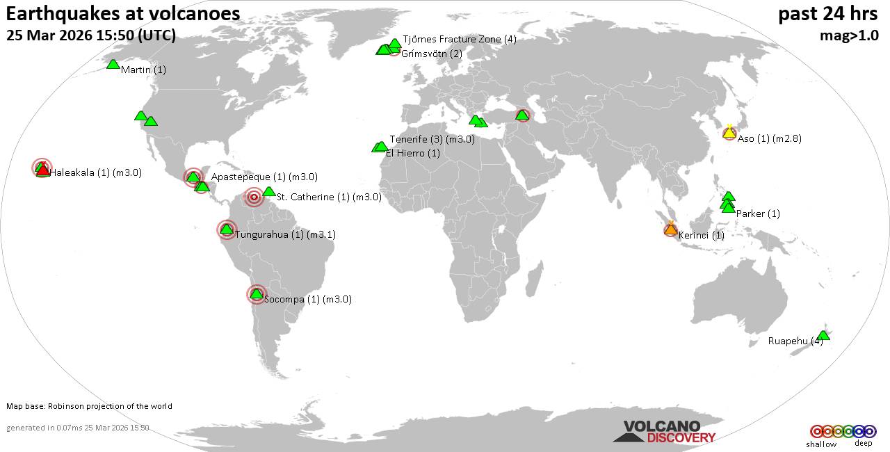 World map showing volcanoes with shallow (less than 50 km) earthquakes within 20 km radius during the past 24 hours on 25 Mar 2026 Number in brackets indicate nr of quakes. Quakes detected near: Apaneca Range (4 quakes between mag 1.5-2.2), Apastepeque (1 quake mag 3.0), Aso (1 quake mag 2.8), Clear Lake (22 quakes between mag 0.2-1.2), El Chichón (1 quake mag 2.0), El Hierro (1 quake mag 1.7)
Eldey (12 quakes between mag 0.6-1.9), Grímsnes (2 quakes between mag 0.9-2.0), Grímsvötn (1 quake mag 2.0), Haleakala (1 quake mag 3.0), Hrómundartindur (7 quakes between mag 0.0-1.0), Kalatungan (1 quake mag 1.8), Kerinci (1 quake mag 2.5), Kolumbo (1 quake mag 1.8), Krísuvík (7 quakes between mag 0.0-1.1), Makaturing (1 quake mag 1.7), Martin (1 quake mag 1.0), Maunaloa (1 quake mag 1.7), Methana (1 quake mag 1.8), Parker (1 quake mag 1.8), Ruapehu (4 quakes between mag 0.7-1.0), St. Catherine (1 quake mag 3.0), Svartsengi (1 quake mag 2.1), Tendürek Dağ (2 quakes between mag 1.0-2.1), Tenerife (4 quakes between mag 0.7-3.0), Tjörnes Fracture Zone (4 quakes between mag 0.0-1.0), Tungurahua (1 quake mag 3.1), Washiba-Kumonotaira (1 quake mag 3.4) (updated 12h50)
Note: Earthquakes within 20 km from and at depths less than 50 km under active volcanoes are reported. The list is not complete because many volcanoes are not monitored and/or seismic data in high resolution is not available publicly.
Volcanoes with recent earthquakes above magnitude 2 or more than 10 quakes are listed below:
Apaneca Range volcano (El Salvador): 4 earthquakes up to magnitude 2.24 earthquakes occurred near (under) the volcano during 13 minutes, the last being recorded quake 17 hours ago. Hypocenter depths ranged between 7.00 and 5.00 km. Earthquake details: 2.2 quake 19 km north of Sonsonate, Departamento de Sonsonate, El Salvador, Mar 24, 2026 01:57 pm (GMT -6) (6 km E) 2.1 quake 19 km north of Sonsonate, Departamento de Sonsonate, El Salvador, 2026-03-24 13:53:53 (6 km E) 1.8 quake 17 km north of Sonsonate, Departamento de Sonsonate, El Salvador, 2026-03-24 13:44:32 (6 km ESE) 1.5 quake 17 km north of Sonsonate, Departamento de Sonsonate, El Salvador, 2026-03-24 13:52:07 (6 km ESE) All earthquakes at Apaneca RangeApastepeque volcano (El Salvador): magnitude 3.0 earthquakeA magnitude 3.0 earthquake occurred at the volcano 5 hours ago. The quake, which might be volcanic in origin, was located at a depth of 10.00 km depth at 6 km distance SSE from the volcano. Earthquake details: Reported seismic-like event (likely no quake): 21 km east of Cojutepeque, Departamento de Cuscatlan, El Salvador, Mar 25, 2026 02:16 am (GMT -6) (6 km SSE) All earthquakes at ApastepequeAso volcano (Kyushu): magnitude 2.8 earthquakeA magnitude 2.8 earthquake occurred at the volcano 14 hours ago. The quake, which might be volcanic in origin, was located at a depth of 10.90 km depth at 14 km distance NNW from the volcano. Earthquake details: 2.8 quake 7.6 km northwest of Aso, Kumamoto, Japan, Mar 25, 2026 07:39 am (GMT +9) (14 km NNW) All earthquakes at AsoClear Lake volcano (California): 22 earthquakes up to magnitude 1.2Possible earthquake swarm: 22 earthquakes occurred near (under) the volcano during 23 hours, the last being recorded quake 33 minutes ago. Hypocenter depths ranged between 7.85 and 0.82 km. Earthquake details: (only 5 largest) 1.2 quake 25 mi north of Santa Rosa, Sonoma County, California, United States, Mar 24, 2026 05:25 pm (Universal Time) (19 km S) 1.2 quake Lake County, 28 mi north of Santa Rosa, Sonoma County, California, United States, Mar 24, 2026 02:30 pm (Universal Time) (15 km S) 1.1 quake Lake County, 25 mi north of Santa Rosa, Sonoma County, California, United States, Mar 25, 2026 06:06 am (Universal Time) (19 km SSE) 1.0 quake 28 mi north of Santa Rosa, Sonoma County, California, United States, Mar 25, 2026 05:59 am (Universal Time) (16 km SSW) 1.0 quake Lake County, 27 mi north of Santa Rosa, Sonoma County, California, United States, Mar 25, 2026 05:10 am (Universal Time) (16 km S) All earthquakes at Clear LakeEldey volcano (Iceland): 12 earthquakes up to magnitude 1.9Possible earthquake swarm: 12 earthquakes occurred near (under) the volcano during 15 hours, the last being recorded quake 9 hours ago. Hypocenter depths ranged between 18.00 and 0.00 km. Earthquake details: (only 5 largest) 1.9 quake Iceland: 2.1 km NW of Eldeyjardrangur Mar 24, 2026 05:49 pm (Reykjavik time) (1 km NW) 1.9 quake 4.2 km WNW of Geirfugladrangur Mar 24, 2026 12:57 pm (Universal Time) (19 km WSW) 1.7 quake Iceland: 3.7 km W of Geirfugladrangur Mar 24, 2026 06:07 pm (Reykjavik time) (19 km WSW) 1.6 quake Iceland: 2.9 km SW of Geirfugladrangur Mar 24, 2026 08:26 pm (Reykjavik time) (18 km WSW) 1.6 quake 4.7 km SSW of Geirfugladrangur Mar 24, 2026 05:45 pm (Universal Time) (19 km WSW) All earthquakes at EldeyEldey is located at the beginning of the Reykjanes Ridge off the SW tip of Iceland. Its highest elevation is the top of Eldey Island, but most of the volcanic edifice is submerged. Several eruptions occurred in historic times, last in 1926. Haleakala volcano (Hawaiian Islands): magnitude 3.0 earthquakeA magnitude 3.0 earthquake occurred at the volcano 9 hours ago. The quake, which might be volcanic in origin, was located at a depth of 10.00 km depth at 18 km distance W from the volcano. Earthquake details: Reported seismic-like event (likely no quake): 14 mi south of Kahului, Maui County, Hawaii, United States, Mar 24, 2026 05:22 pm (GMT -10) (18 km W) All earthquakes at HaleakalaKerinci volcano (Sumatra): magnitude 2.5 earthquakeA magnitude 2.5 earthquake occurred at the volcano 20 hours ago. The quake, which might be volcanic in origin, was located at a depth of 10.00 km depth at 10 km distance WNW from the volcano. Earthquake details: 2.5 quake Kabupaten Solok Selatan, Provinsi Sumatera Barat, 49 km northwest of Sungai Penuh, Indonesia, Mar 24, 2026 11:26 pm (GMT +7) (10 km WNW) All earthquakes at KerinciSt. Catherine volcano (Caribbean): magnitude 3.0 earthquakeA magnitude 3.0 earthquake occurred at the volcano 12 hours ago. The quake, which might be volcanic in origin, was located at a depth of 10.00 km depth at 16 km distance WSW from the volcano. Earthquake details: Unconfirmed earthquake or seismic-like event: 12 km northeast of Valencia, Carabobo, Venezuela, Mar 24, 2026 08:54 pm (GMT -4) (16 km WSW) All earthquakes at St. CatherineSvartsengi volcano (Reykjanes Peninsula, Iceland): magnitude 2.1 earthquakeA magnitude 2.1 earthquake occurred at the volcano 22 hours ago. The quake, which might be volcanic in origin, was located at a depth of 18.60 km depth at 15 km distance SSW from the volcano. Earthquake details: 2.1 quake Iceland: 7.6 km SE of Reykjanestá Mar 24, 2026 02:49 pm (Reykjavik time) (15 km SSW) All earthquakes at SvartsengiTendürek Dağ volcano (Turkey): 2 earthquakes up to magnitude 2.12 earthquakes occurred near (under) the volcano during 8 hours, the last being recorded quake 5 hours ago. Hypocenter depths ranged between 7.10 and 7.00 km. Earthquake details: 2.1 quake 14 km south of Dogubayazit, Agri, Turkey, Mar 25, 2026 08:00 am (Universal Time) (18 km ENE) 1.0 quake Van, 33 km southwest of Dogubayazit, Agri, Turkey, Mar 25, 2026 12:16 am (Universal Time) (5 km SW) All earthquakes at Tendürek DağTenerife volcano (Canary Islands): 4 earthquakes up to magnitude 3.04 earthquakes occurred near (under) the volcano during 19 hours, the last being recorded quake 3 hours ago. Hypocenter depths ranged between 15.00 and 6.00 km. Earthquake details: Reported seismic-like event (likely no quake): 28 km west of Santa Cruz de Tenerife, Spain, Mar 25, 2026 09:25 am (GMT +0) (16 km NE) 1.4 quake 15 km north of Arona, Santa Cruz de Tenerife, Canary Islands, Spain, Mar 25, 2026 06:06 am (Universal Time) (7 km SW) 1.3 quake 16 km north of Arona, Santa Cruz de Tenerife, Canary Islands, Spain, Mar 24, 2026 05:29 pm (Universal Time) (6 km WSW) 0.7 quake 17 km northeast of Arona, Santa Cruz de Tenerife, Canary Islands, Spain, Mar 24, 2026 02:50 pm (Universal Time) (7 km SE) All earthquakes at TenerifeTungurahua volcano (Ecuador): magnitude 3.1 earthquakeA magnitude 3.1 earthquake occurred at the volcano 19 hours ago. The quake, which might be volcanic in origin, was located at a depth of 10.00 km depth at 9 km distance N from the volcano. Earthquake details: 3.1 quake 18 km east of Ambato, Tungurahua, Ecuador, Mar 24, 2026 12:46 pm (GMT -5) (9 km N) All earthquakes at TungurahuaUnnamed 52.92°N/158.52°E volcano (Southern Kamchatka): magnitude 3.0 earthquakeA magnitude 3.0 earthquake occurred at the volcano 24 hours ago. The quake, which might be volcanic in origin, was located at a depth of 10.00 km depth at 15 km distance NNE from the volcano. Earthquake details: Reported seismic-like event (likely no quake): 3.5 km south of Petropavlovsk-Kamchatskiy, Kamchatka, Russia, Mar 25, 2026 01:05 am (GMT +12) (15 km NNE) All earthquakes at Unnamed 52.92°N/158.52°EWashiba-Kumonotaira volcano (Honshu): magnitude 3.4 earthquakeA magnitude 3.4 earthquake occurred at the volcano 24 hours ago. The quake, which might be volcanic in origin, was located at a depth of 0 km depth at 1 km distance SSE from the volcano. Earthquake details: 3.4 quake 48 km southeast of Toyama, Toyama, Japan, Mar 24, 2026 10:11 pm (GMT +9) (1 km SSE) All earthquakes at Washiba-Kumonotairahttps://www.volcanodiscovery.com/earthquakes-volcanoes/news/298494/Volcano-earthquake-report-for-Wednesday-25-Mar-2026.html
0
12
Read More
|
Moderate magnitude 4.6 earthquake 11 km northwest of Miki, Japan
Webmaster
5 hours ago
Moderate magnitude 4.6 earthquake 11 km northwest of Miki, Japan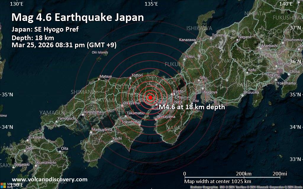 An earthquake of magnitude 4.6 occurred in the evening on Wednesday, March 25th, 2026, at 8:31 pm local time near Miki, Miki Shi, Hyōgo, Japan, as reported by Japan's National Research Institute for Earth Science and Disaster Resilience (NIED).
According to preliminary data, the quake was located at a shallow depth of 18. km. Shallow earthquakes are felt more strongly than deeper ones as they are closer to the surface. The exact magnitude, epicenter, and depth of the quake might be revised within the next few hours or minutes as seismologists review data and refine their calculations, or as other agencies issue their report.
Based on the preliminary seismic data, the quake was probably felt by many people in the area of the epicenter. It should not have caused significant damage, other than objects falling from shelves, broken windows, etc.
In Yashiro (pop. 21,600) located 2 km from the epicenter, Ono (pop. 47,600) 6 km away, Kato (pop. 40,600) 7 km away, Nishiwaki (pop. 38,700) 9 km away, Kasai (pop. 42,700) 11 km away, and Miki (pop. 75,500) 11 km away, the quake should have been felt as light shaking.
Weak shaking might have been felt in Kakogawacho-honmachi (pop. 271,600) located 19 km from the epicenter, Kobe (pop. 1,525,200) 31 km away, and Osaka (pop. 2,753,900) 55 km away.
VolcanoDiscovery will automatically update magnitude and depth if these change and follow up if other significant news about the quake become available. If you’re in the area, please send us your experience through our reporting mechanism, either online or via our mobile app. This will help us provide more first-hand updates to anyone around the globe who wants to know more about this quake.
Earthquake data: Date & time: Mar 25, 2026 08:31 pm (GMT +9) local time (25 Mar 2026 11:31 GMT)Magnitude: 4.2 Depth: 20.00 km Epicenter latitude / longitude: 34.9°N / 135°E  ( Kato Shi, Hyōgo, Japan) Primary data source: EMSChttps://www.volcanodiscovery.com/earthquake/news/298528/Moderate-magnitude-46-earthquake-11-km-northwest-of-Miki-Japan.html
0
101
Read More
|
Seismic-like event, possible earthquake, reported few minutes ago near Osaka, Osaka, Japan
Webmaster
6 hours ago
Seismic-like event, possible earthquake, reported few minutes ago near Osaka, Osaka, Japan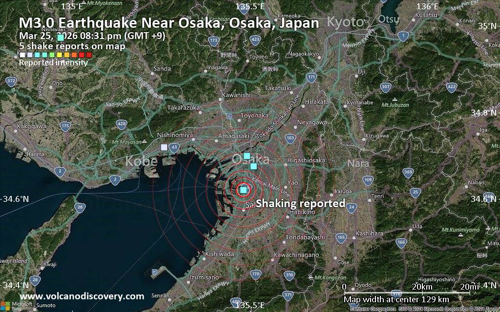 Unconfirmed quake or seismic-like event reported: 8.2 km south of Osaka, Osaka, Japan, 4 minutes ago We are receiving unverified early reports of ground shaking possibly caused by seismic activity in or near Osaka, Osaka, Japan on 25 Mar 2026 (GMT) at approximately 11:31 GMT.
There are no details yet on the magnitude or depth of this possible quake. If confirmed, we can expect more accurate data to emerge in the next few minutes. The location, magnitude and time mentioned are indicative, based on our best-fit seismic model. They are temporary until our AllQuakes monitoring service receives more exact scientific data from a national or international seismological agency. Check back here shortly and stay safe.
Earthquake data: Date & time: Mar 25, 2026 08:31 pm (GMT +9) local time (25 Mar 2026 11:31 GMT)Magnitude: unspecified Depth: unspecified Epicenter latitude / longitude: 34.62°N / 135.48°E ( Osaka, Japan) Primary data source: VolcanoDiscoveryhttps://www.volcanodiscovery.com/earthquake/news/298526/Seismic-like-event-possible-earthquake-reported-few-minutes-ago-near-Osaka-Osaka-Japan.html
0
50
Read More
|
Magnitude 5.2 earthquake strikes near Hihifo, Niuas, Tonga
Webmaster
7 hours ago
Magnitude 5.2 earthquake strikes near Hihifo, Niuas, Tonga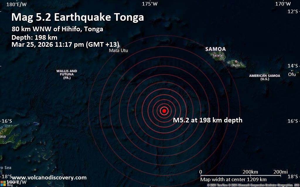 An intermediate to deep magnitude 5.2 earthquake was reported late at night near Hihifo, Niuas, Tonga.
According to the United States Geological Survey, the quake hit on Wednesday, March 25th, 2026, at 11:17 pm local time at an intermediate to considerable depth of 198.05 km. The strength of the earthquake may have been tempered by its relative great depth below the surface, which makes it feel weaker in absolute terms. The exact magnitude, epicenter, and depth of the quake might be revised within the next few hours or minutes as seismologists review data and refine their calculations, or as other agencies issue their report.
Our monitoring service identified a second report from the European-Mediterranean Seismological Centre (EMSC) which listed the quake at magnitude 5.2 as well.
Towns or cities near the epicenter where the quake might have been felt as very weak shaking include Hihifo (pop. 300) located 80 km from the epicenter, and Vaipoa (pop. 170) 81 km away.
VolcanoDiscovery will automatically update magnitude and depth if these change and follow up if other significant news about the quake become available. If you’re in the area, please send us your experience through our reporting mechanism, either online or via our mobile app. This will help us provide more first-hand updates to anyone around the globe who wants to know more about this quake.
Earthquake data: Date & time: Mar 25, 2026 11:17 pm (GMT +13) local time (25 Mar 2026 10:17 GMT)Magnitude: 5.2 Depth: 198.05 km Epicenter latitude / longitude: 15.63°S / 174.46°W  ( Tonga) Primary data source: USGShttps://www.volcanodiscovery.com/earthquake/news/298520/Magnitude-52-earthquake-strikes-near-Hihifo-Niuas-Tonga.html
0
21
Read More
|
Moderate yet deep 5.4 quake hits near Hihifo, Niuas, Tonga
Webmaster
7 hours ago
Moderate yet deep 5.4 quake hits near Hihifo, Niuas, Tonga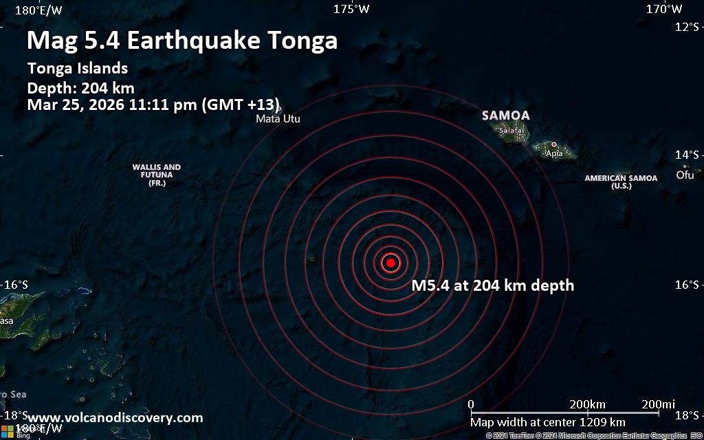 The German Research Centre for Geosciences (GFZ) reported a magnitude 5.4 quake in Tonga near Hihifo, Niuas, only 10 minutes ago. The earthquake hit late at night on Wednesday, March 25th, 2026, at 11:11 pm local time at an intermediate to considerable depth of 204. km. The exact magnitude, epicenter, and depth of the quake might be revised within the next few hours or minutes as seismologists review data and refine their calculations, or as other agencies issue their report.
A second report was later issued by the citizen-seismograph network of RaspberryShake, which listed it as a magnitude 5.5 earthquake. A third agency, France's Réseau National de Surveillance Sismique (RéNaSS), reported the same quake at magnitude 5.0.
Towns or cities near the epicenter where the quake might have been felt as very weak shaking include Hihifo (pop. 300) located 70 km from the epicenter, and Vaipoa (pop. 170) 71 km away.
VolcanoDiscovery will automatically update magnitude and depth if these change and follow up if other significant news about the quake become available. If you’re in the area, please send us your experience through our reporting mechanism, either online or via our mobile app. This will help us provide more first-hand updates to anyone around the globe who wants to know more about this quake.
Earthquake data: Date & time: Mar 25, 2026 10:11 am (Universal Time) local time (25 Mar 2026 10:11 GMT)Magnitude: 5.4 Depth: 204.00 km Epicenter latitude / longitude: 15.66°S / 174.38°W ( Tonga) Primary data source: GFZhttps://www.volcanodiscovery.com/earthquake/news/298518/Moderate-yet-deep-54-quake-hits-near-Hihifo-Niuas-Tonga.html
0
5
Read More
|
Moderate 4.4 quake hits near La Spezia, Province of La Spezia, Liguria, Italy
Webmaster
10 hours ago
Moderate 4.4 quake hits near La Spezia, Province of La Spezia, Liguria, Italy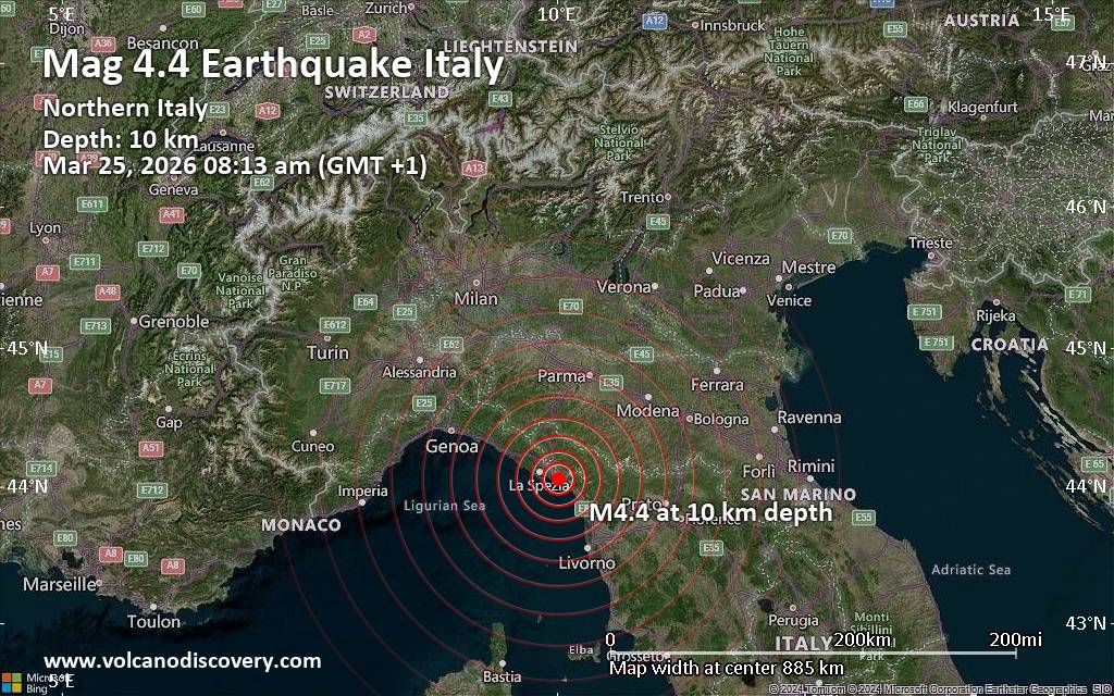 Just 4 minutes ago, a 4.4-magnitude earthquake struck near La Spezia, Province of La Spezia, Liguria, Italy. The tremor was recorded in the morning on Wednesday, March 25th, 2026, at 8:13 am local time, at a shallow depth of 10. km below the surface.
The event was filed by the German Research Centre for Geosciences (GFZ), the first seismological agency to report it.
A second report was later issued by the citizen-seismograph network of RaspberryShake, which listed it as a magnitude 4.4 earthquake as well.
Based on the preliminary seismic data, the quake was probably felt by many people in the area of the epicenter. It should not have caused significant damage, other than objects falling from shelves, broken windows, etc.
In Casano-Dogana-Isola (pop. 6,700) located 2 km from the epicenter, Marina di Carrara (pop. 25,000) 3 km away, Carrara (pop. 58,700) 7 km away, Sarzana (pop. 20,400) 7 km away, Marina di Massa (pop. 19,100) 9 km away, and Massa (pop. 64,800) 10 km away, the quake should have been felt as light shaking.
Weak shaking might have been felt in La Spezia (pop. 93,300) located 16 km from the epicenter, and Viareggio (pop. 62,200) 28 km away.
Other towns or cities near the epicenter where the quake might have been felt as very weak shaking include Genoa (pop. 580,100) located 94 km from the epicenter.
VolcanoDiscovery will automatically update magnitude and depth if these change and follow up if other significant news about the quake become available. If you’re in the area, please send us your experience through our reporting mechanism, either online or via our mobile app. This will help us provide more first-hand updates to anyone around the globe who wants to know more about this quake.
Earthquake data: Date & time: Mar 25, 2026 08:13 am (GMT +1) local time (25 Mar 2026 07:13 GMT)Magnitude: 4.4 Depth: 10.00 km Epicenter latitude / longitude: 44.06°N / 10.02°E  ( Provincia di La Spezia, Liguria, Italy) Primary data source: GFZhttps://www.volcanodiscovery.com/earthquake/news/298514/Moderate-44-quake-hits-near-La-Spezia-Province-of-La-Spezia-Liguria-Italy.html
0
8
Read More
|
Seismic-like event, possible earthquake, reported few minutes ago near Valencia, Carabobo, Venezuela
Webmaster
16 hours ago
Seismic-like event, possible earthquake, reported few minutes ago near Valencia, Carabobo, Venezuela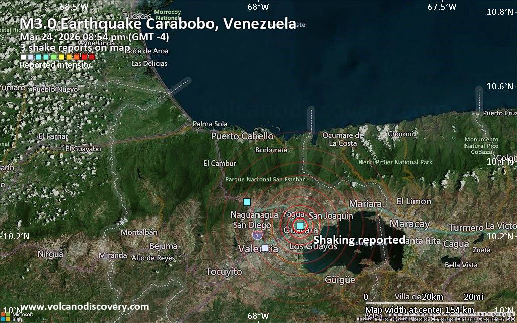 Unconfirmed quake or seismic-like event reported: 14 km northeast of Valencia, Carabobo, Venezuela, 6 minutes ago We are receiving unverified early reports of ground shaking possibly caused by seismic activity in or near Valencia, Carabobo, Venezuela on 25 Mar 2026 (GMT) at approximately 00:54 GMT.
There are no details yet on the magnitude or depth of this possible quake. If confirmed, we can expect more accurate data to emerge in the next few minutes. The location, magnitude and time mentioned are indicative, based on our best-fit seismic model. They are temporary until our AllQuakes monitoring service receives more exact scientific data from a national or international seismological agency. Check back here shortly and stay safe.
Earthquake data: Date & time: Mar 24, 2026 08:54 pm (GMT -4) local time (25 Mar 2026 00:54 GMT)Magnitude: unspecified Depth: unspecified Epicenter latitude / longitude: 10.23°N / 67.89°W  ( Carabobo, Venezuela) Primary data source: VolcanoDiscoveryhttps://www.volcanodiscovery.com/earthquake/news/298495/Seismic-like-event-possible-earthquake-reported-few-minutes-ago-near-Valencia-Carabobo-Venezuela.html
0
7
Read More
|
World Earthquake Report for Tuesday, 24 March 2026
Webmaster
17 hours ago
World Earthquake Report for Tuesday, 24 March 2026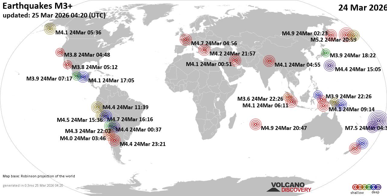 Worldwide earthquakes above magnitude 3 during the past 24 hours on 25 Mar 2026 Magnitude 7+: 1 earthquake Magnitude 5+: 3 earthquakes Magnitude 4+: 34 earthquakes Magnitude 3+: 176 earthquakes Magnitude 2+: 370 earthquakes No quakes of magnitude 6 or higher 10 largest earthquakes in the world (24 Mar 2026)Tuesday, Mar 24, 2026, at 05:37 pm (GMT +13) - Tuesday, Mar 24, 2026, at 05:51 pm (GMT +13) - Tuesday, Mar 24, 2026, at 10:59 am (GMT -10) - Tuesday, Mar 24, 2026, at 06:22 pm (GMT +13) - Tuesday, Mar 24, 2026, at 01:30 pm (GMT +13) - Tuesday, Mar 24, 2026, at 01:23 pm (GMT +11) - Wednesday, Mar 25, 2026, at 09:35 am (GMT +11) - Wednesday, Mar 25, 2026, at 01:47 am (GMT +5) - Tuesday, Mar 24, 2026, at 06:18 pm (GMT +13) - Tuesday, Mar 24, 2026, at 05:56 am (Paris time) - Earthquakes reported feltTuesday, Mar 24, 2026, at 11:57 pm (GMT +2) - Monday, Mar 23, 2026, at 08:04 pm (GMT -4) - Tuesday, Mar 24, 2026, at 12:49 pm (GMT +1) - Tuesday, Mar 24, 2026, at 05:56 am (Paris time) - Tuesday, Mar 24, 2026, at 12:31 am (GMT -7) - Tuesday, Mar 24, 2026, at 05:37 pm (GMT +13) - Tuesday, Mar 24, 2026, at 08:21 pm (GMT -3) - Tuesday, Mar 24, 2026, at 05:56 am (GMT +1) - Monday, Mar 23, 2026, at 09:49 pm (GMT -7) - Tuesday, Mar 24, 2026, at 12:46 pm (GMT -5) - Tuesday, Mar 24, 2026, at 03:13 am (Universal Time) - Tuesday, Mar 24, 2026, at 11:55 pm (GMT +2) - Tuesday, Mar 24, 2026, at 05:57 am (Paris time) - Tuesday, Mar 24, 2026, at 10:16 pm (Universal Time) - Earthquake stats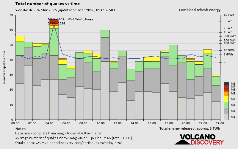 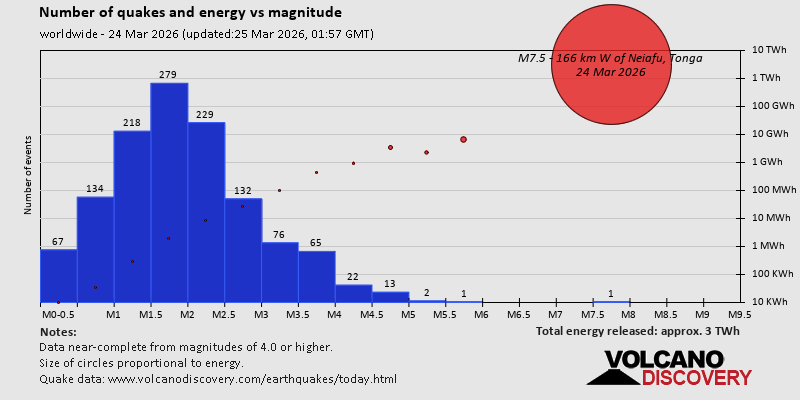  https://www.volcanodiscovery.com/earthquake/news/298437/World-Earthquake-Report-for-Tuesday-24-March-2026.html https://www.volcanodiscovery.com/earthquake/news/298437/World-Earthquake-Report-for-Tuesday-24-March-2026.html
0
3
Read More
|
Thursday: Sunny Intervals, Minimum Temperature: 6°C (42°F) Maximum Temperature: 9°C (49°F)
Webmaster
Yesterday at 11:50 PM
Maximum Temperature: 9°C (49°F), Minimum Temperature: 6°C (42°F), Wind Direction: north-westerly, Wind Speed: 9mph, Visibility: Very Good, Pressure: 1022mb, Humidity: 58%, UV Risk: 3, Pollution: Low, Sunrise: 05:55 GMT, Sunset: 18:35 GMT Source: Thursday: Sunny Intervals, Minimum Temperature: 6°C (42°F) Maximum Temperature: 9°C (49°F)
0
23
Read More
|
Wednesday: Hail Showers, Minimum Temperature: 0°C (31°F) Maximum Temperature: 8°C (46°F)
Webmaster
Yesterday at 11:50 PM
Maximum Temperature: 8°C (46°F), Minimum Temperature: 0°C (31°F), Wind Direction: north-westerly, Wind Speed: 17mph, Visibility: Good, Pressure: 1008mb, Humidity: 68%, UV Risk: 2, Pollution: Low, Sunrise: 05:58 GMT, Sunset: 18:33 GMT Source: Wednesday: Hail Showers, Minimum Temperature: 0°C (31°F) Maximum Temperature: 8°C (46°F)
0
23
Read More
|
Volcano earthquake report for Tuesday, 24 Mar 2026
Webmaster
Yesterday at 11:50 PM
Volcano earthquake report for Tuesday, 24 Mar 2026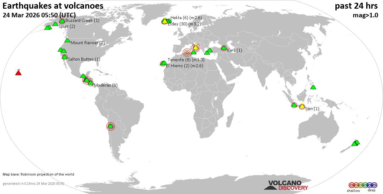 World map showing volcanoes with shallow (less than 50 km) earthquakes within 20 km radius during the past 24 hours on 24 Mar 2026 Number in brackets indicate nr of quakes. Quakes detected near: Apaneca Range (4 quakes between mag 1.5-2.2), Aso (1 quake mag 2.8), Bardarbunga (7 quakes between mag 0.0-1.5), Brennisteinsfjöll (4 quakes between mag 0.0-1.2), Buzzard Creek (1 quake mag 1.0), Cerro Singüil (1 quake mag 3.0)
Churchill (1 quake mag 1.1), Clear Lake (27 quakes between mag 0.3-1.4), Colima (1 quake mag 3.3), Coso (3 quakes between mag 0.6-1.1), Cuilapa-Barbarena (1 quake mag 3.0), El Chichón (3 quakes between mag 2.1-2.6), El Hierro (2 quakes between mag 2.3-2.6), Eldey (12 quakes between mag 0.6-1.9), Etna (1 quake mag 1.0), Gran Canaria (1 quake mag 1.0), Grímsvötn (1 quake mag 2.0), Katla (5 quakes between mag 0.2-1.7), Kerinci (1 quake mag 2.5), Kilauea (1 quake mag 2.0), Kolumbo (1 quake mag 1.8), Kupreanof (7 quakes between mag 0.0-1.1), Liamuiga (1 quake mag 3.0), Loihi (1 quake mag 1.8), Loki-Fögrufjöll volcano (1 quake mag 1.2), Mauna Kea (1 quake mag 1.8), Maunaloa (1 quake mag 1.7), Methana (2 quakes between mag 1.6-1.8), Mono Lake (1 quake mag 1.8), Okmok (1 quake mag 1.0), Parker (1 quake mag 1.8), Ruapehu (4 quakes between mag 0.7-1.1), Shishaldin (1 quake mag 1.0), Socompa (1 quake mag 3.0), Svartsengi (2 quakes between mag 0.6-2.1), Taupo (1 quake mag 2.6), Tenerife (9 quakes between mag 0.7-1.3), Tungurahua (1 quake mag 3.1), Vatnafjöll (3 quakes between mag 0.1-1.9), Washiba-Kumonotaira (1 quake mag 3.4) (updated 23h50)
Note: Earthquakes within 20 km from and at depths less than 50 km under active volcanoes are reported. The list is not complete because many volcanoes are not monitored and/or seismic data in high resolution is not available publicly.
Volcanoes with recent earthquakes above magnitude 2 or more than 10 quakes are listed below:
Apaneca Range volcano (El Salvador): 4 earthquakes up to magnitude 2.24 earthquakes occurred near (under) the volcano during 13 minutes, the last being recorded quake 4 hours ago. Hypocenter depths ranged between 7.00 and 5.00 km. Earthquake details: 2.2 quake 19 km north of Sonsonate, Departamento de Sonsonate, El Salvador, Mar 24, 2026 01:57 pm (GMT -6) (6 km E) 2.1 quake 19 km north of Sonsonate, Departamento de Sonsonate, El Salvador, 2026-03-24 13:53:53 (6 km E) 1.8 quake 17 km north of Sonsonate, Departamento de Sonsonate, El Salvador, 2026-03-24 13:44:32 (6 km ESE) 1.5 quake 17 km north of Sonsonate, Departamento de Sonsonate, El Salvador, 2026-03-24 13:52:07 (6 km ESE) All earthquakes at Apaneca RangeAso volcano (Kyushu): magnitude 2.8 earthquakeA magnitude 2.8 earthquake occurred at the volcano 1 hour 10 minutes ago. The quake, which might be volcanic in origin, was located at a depth of 10.90 km depth at 14 km distance NNW from the volcano. Earthquake details: 2.8 quake 7.6 km northwest of Aso, Kumamoto, Japan, Mar 25, 2026 07:39 am (GMT +9) (14 km NNW) All earthquakes at AsoCerro Singüil volcano (El Salvador): magnitude 3.0 earthquakeA magnitude 3.0 earthquake occurred at the volcano 20 hours ago. The quake, which might be volcanic in origin, was located at a depth of 10.00 km depth at 8 km distance SE from the volcano. Earthquake details: Reported seismic-like event (likely no quake): 4.3 km west of Santa Ana, Departamento de Santa Ana, El Salvador, Mar 23, 2026 09:50 pm (GMT -6) (8 km SE) All earthquakes at Cerro SingüilClear Lake volcano (California): 27 earthquakes up to magnitude 1.4Possible earthquake swarm: 27 earthquakes occurred near (under) the volcano during 16 hours, the last being recorded quake 4 hours ago. Hypocenter depths ranged between 7.85 and 0.35 km. Earthquake details: (only 5 largest) 1.4 quake Lake County, 28 mi north of Santa Rosa, Sonoma County, California, United States, Mar 24, 2026 03:38 am (Universal Time) (15 km S) 1.3 quake 4.5 mi north of Clearlake, Lake County, California, United States, Mar 24, 2026 07:31 am (Universal Time) (14 km ENE) 1.3 quake 27 mi north of Santa Rosa, Sonoma County, California, United States, Mar 24, 2026 05:02 am (Universal Time) (17 km S) 1.3 quake Lake County, 28 mi north of Santa Rosa, Sonoma County, California, United States, Mar 24, 2026 05:11 am (Universal Time) (15 km S) 1.3 quake 27 mi north of Santa Rosa, Sonoma County, California, United States, Mar 23, 2026 11:23 pm (GMT -7) (18 km SSW) All earthquakes at Clear LakeColima volcano (Western & Central Mexico): magnitude 3.3 earthquakeA magnitude 3.3 earthquake occurred at the volcano 24 hours ago. The quake, which might be volcanic in origin, was located at a depth of 41.70 km depth at 19 km distance SW from the volcano. Earthquake details: 3.3 quake 15 km north of Colima, Estado de Colima, Mexico, Mar 23, 2026 06:19 pm (GMT -6) (19 km SW) All earthquakes at ColimaCuilapa-Barbarena volcano (Guatemala): magnitude 3.0 earthquakeA magnitude 3.0 earthquake occurred at the volcano 19 hours ago. The quake, which might be volcanic in origin, was located at a depth of 11.00 km depth at 9 km distance SSE from the volcano. Earthquake details: 3.0 quake 6.8 km west of Cuilapa, Departamento de Santa Rosa, Guatemala, Mar 23, 2026 10:50 pm (GMT -6) (9 km SSE) All earthquakes at Cuilapa-BarbarenaEl Chichón volcano (Southern Mexico): 3 earthquakes up to magnitude 2.63 earthquakes occurred near (under) the volcano during 47 minutes, the last being recorded quake 21 hours ago. Hypocenter depths ranged between 3.40 and 3.00 km. Earthquake details: 2.6 quake Estado de Chiapas, 37 km southwest of Teapa, Estado de Tabasco, Mexico, Mar 23, 2026 09:16 pm (GMT -6) (0 km WSW) 2.4 quake Estado de Chiapas, 37 km southwest of Teapa, Estado de Tabasco, Mexico, Mar 23, 2026 08:32 pm (GMT -6) (0 km SW) 2.1 quake Estado de Chiapas, 36 km southwest of Teapa, Estado de Tabasco, Mexico, Mar 23, 2026 08:29 pm (GMT -6) (2 km ESE) All earthquakes at El ChichónEl Hierro volcano (Canary Islands): 2 earthquakes up to magnitude 2.62 earthquakes occurred near (under) the volcano during 4 hours, the last being recorded quake 20 hours ago. Hypocenter depths ranged between 19.20 and 0.00 km. Earthquake details: 2.6 quake 18 km south of Frontera, Santa Cruz de Tenerife, Canary Islands, Spain, Mar 24, 2026 03:50 am (Universal Time) (5 km SSW) 2.3 quake 12 km southeast of Valverde, Santa Cruz de Tenerife, Canary Islands, Spain, Mar 24, 2026 12:01 am (Universal Time) (19 km NE) All earthquakes at El HierroEldey volcano (Iceland): 12 earthquakes up to magnitude 1.9Possible earthquake swarm: 12 earthquakes occurred near (under) the volcano during 19 hours, the last being recorded quake 3 hours ago. Hypocenter depths ranged between 18.00 and 0.00 km. Earthquake details: (only 5 largest) 1.9 quake Iceland: 2.1 km NW of Eldeyjardrangur Mar 24, 2026 05:49 pm (Reykjavik time) (1 km NW) 1.9 quake Iceland: 4.2 km WNW of Geirfugladrangur Mar 24, 2026 12:57 pm (Reykjavik time) (19 km WSW) 1.9 quake Iceland: 2.8 km W of Geirfugladrangur Mar 24, 2026 09:43 am (Reykjavik time) (18 km WSW) 1.7 quake Iceland: 3.7 km W of Geirfugladrangur Mar 24, 2026 06:07 pm (Reykjavik time) (19 km WSW) 1.7 quake Iceland: 1.6 km NW of Geirfugladrangur Mar 24, 2026 09:59 am (Reykjavik time) (16 km WSW) All earthquakes at EldeyEldey is located at the beginning of the Reykjanes Ridge off the SW tip of Iceland. Its highest elevation is the top of Eldey Island, but most of the volcanic edifice is submerged. Several eruptions occurred in historic times, last in 1926. Kerinci volcano (Sumatra): magnitude 2.5 earthquakeA magnitude 2.5 earthquake occurred at the volcano 7 hours ago. The quake, which might be volcanic in origin, was located at a depth of 10.00 km depth at 10 km distance WNW from the volcano. Earthquake details: 2.5 quake Kabupaten Solok Selatan, Provinsi Sumatera Barat, 49 km northwest of Sungai Penuh, Indonesia, Mar 24, 2026 11:26 pm (GMT +7) (10 km WNW) All earthquakes at KerinciLiamuiga volcano (Caribbean): magnitude 3.0 earthquakeA magnitude 3.0 earthquake occurred at the volcano 12 hours ago. The quake, which might be volcanic in origin, was located at a depth of 10.00 km depth at 11 km distance SE from the volcano. Earthquake details: Reported seismic-like event (likely no quake): 0.1 km west of Basseterre, Saint George Basseterre, Saint Kitts and Nevis, Mar 24, 2026 08:07 am (GMT -4) (11 km SE) All earthquakes at LiamuigaSocompa volcano (Northern Chile, Bolivia and Argentina): magnitude 3.0 earthquakeA magnitude 3.0 earthquake occurred at the volcano 20 hours ago. The quake, which might be volcanic in origin, was located at a depth of 10.00 km depth at 13 km distance SSE from the volcano. Earthquake details: Reported quake or seismic-like event: Departamento de Los Andes, Salta Province, Argentina, Mar 24, 2026 12:26 am (GMT -3) (13 km SSE) All earthquakes at SocompaSvartsengi volcano (Reykjanes Peninsula, Iceland): 2 earthquakes up to magnitude 2.12 earthquakes occurred near (under) the volcano during 9 hours, the last being recorded quake 9 hours ago. Hypocenter depths ranged between 18.60 and 5.00 km. Earthquake details: 2.1 quake Iceland: 7.6 km SE of Reykjanestá Mar 24, 2026 02:49 pm (Reykjavik time) (15 km SSW) 0.6 quake 5.1 km WSW of Grindavík Mar 24, 2026 05:20 am (Universal Time) (8 km SW) All earthquakes at SvartsengiTaupo volcano (New Zealand): magnitude 2.6 earthquakeA magnitude 2.6 earthquake occurred at the volcano 23 hours ago. The quake, which might be volcanic in origin, was located at a depth of 5.00 km depth at 16 km distance ESE from the volcano. Earthquake details: 2.6 quake 24 km south of Taupo, Waikato, New Zealand, Mar 24, 2026 01:37 pm (GMT +13) (16 km ESE) All earthquakes at TaupoTungurahua volcano (Ecuador): magnitude 3.1 earthquakeA magnitude 3.1 earthquake occurred at the volcano 6 hours ago. The quake, which might be volcanic in origin, was located at a depth of 10.00 km depth at 9 km distance N from the volcano. Earthquake details: 3.1 quake 18 km east of Ambato, Tungurahua, Ecuador, Mar 24, 2026 12:46 pm (GMT -5) (9 km N) All earthquakes at TungurahuaUnnamed 52.92°N/158.52°E volcano (Southern Kamchatka): magnitude 3.0 earthquakeA magnitude 3.0 earthquake occurred at the volcano 11 hours ago. The quake, which might be volcanic in origin, was located at a depth of 10.00 km depth at 15 km distance NNE from the volcano. Earthquake details: Reported seismic-like event (likely no quake): 3.5 km south of Petropavlovsk-Kamchatskiy, Kamchatka, Russia, Mar 25, 2026 01:05 am (GMT +12) (15 km NNE) All earthquakes at Unnamed 52.92°N/158.52°EWashiba-Kumonotaira volcano (Honshu): magnitude 3.4 earthquakeA magnitude 3.4 earthquake occurred at the volcano 11 hours ago. The quake, which might be volcanic in origin, was located at a depth of 0 km depth at 1 km distance SSE from the volcano. Earthquake details: 3.4 quake 48 km southeast of Toyama, Toyama, Japan, Mar 24, 2026 10:11 pm (GMT +9) (1 km SSE) All earthquakes at Washiba-Kumonotairahttps://www.volcanodiscovery.com/earthquakes-volcanoes/news/298388/Volcano-earthquake-report-for-Tuesday-24-Mar-2026.html
0
3
Read More
|
Moderate magnitude 4.6 earthquake 24 km southwest of Ioannina, Greece
Webmaster
Yesterday at 10:04 PM
Moderate magnitude 4.6 earthquake 24 km southwest of Ioannina, Greece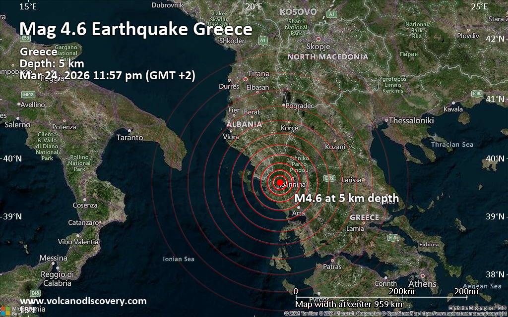 A magnitude 4.6 earthquake near Ioannina, Epirus, Greece, was reported only 6 minutes ago by the European-Mediterranean Seismological Centre (EMSC), considered one of the key international agencies that monitor seismic activity worldwide. The earthquake occurred at a very shallow depth of 5. km beneath the epicenter late at night on Tuesday, March 24th, 2026, at 11:57 pm local time. The exact magnitude, epicenter, and depth of the quake might be revised within the next few hours or minutes as seismologists review data and refine their calculations, or as other agencies issue their report.
A second report was later issued by The Aristotle University of Thessaloniki Geophysical Lab. (AUTH), which listed it as a magnitude 4.2 earthquake. Other agencies reporting the same quake include The Seismological Survey of Serbia (SSS) at magnitude 4.4, the National Observatory of Athens (NOA) at magnitude 4.4, the German Research Centre for Geosciences (GFZ) at magnitude 4.6, The Seismological Laboratory of the University of Athens (UOA) at magnitude 4.3, and the citizen-seismograph network of RaspberryShake at magnitude 4.4.
Based on the preliminary seismic data, the quake was probably felt by many people in the area of the epicenter. It should not have caused significant damage, other than objects falling from shelves, broken windows, etc.
In Paramythia (pop. 2,600) located 15 km from the epicenter, Eleousa (pop. 3,500) 22 km away, and Kardamitsia (pop. 3,200) 23 km away, the quake should have been felt as light shaking.
Weak shaking might have been felt in Ioannina (pop. 65,600) located 24 km from the epicenter, Anatoli (pop. 9,800) 25 km away, Igoumenitsa (pop. 9,500) 29 km away, Arta (pop. 21,900) 59 km away, and Preveza (pop. 17,300) 72 km away.
VolcanoDiscovery will automatically update magnitude and depth if these change and follow up if other significant news about the quake become available. If you’re in the area, please send us your experience through our reporting mechanism, either online or via our mobile app. This will help us provide more first-hand updates to anyone around the globe who wants to know more about this quake.
Earthquake data: Date & time: Mar 24, 2026 09:57 pm (Universal Time) local time (24 Mar 2026 21:57 GMT)Magnitude: 4.5 Depth: 5.00 km Epicenter latitude / longitude: 39.59°N / 20.58°E  ( Dimos Zitsa, Epirus, Greece) Primary data source: EMSChttps://www.volcanodiscovery.com/earthquake/news/298483/Moderate-magnitude-46-earthquake-24-km-southwest-of-Ioannina-Greece.html
0
9
Read More
|
Small magnitude 3.7 quake hits 13 miles south of Larsen Bay, Alaska, United States around noon
Webmaster
Yesterday at 09:10 PM
Small magnitude 3.7 quake hits 13 miles south of Larsen Bay, Alaska, United States around noon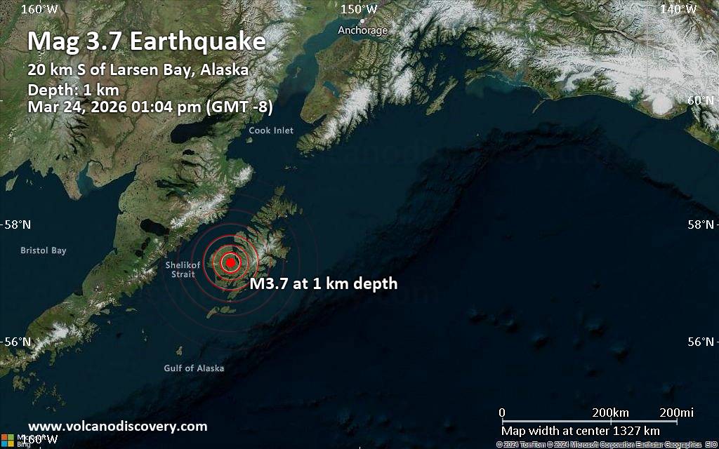 A magnitude 3.7 earthquake near Larsen Bay, Kodiak Island, Alaska, USA, was reported only 4 minutes ago by the United States Geological Survey, considered the key international and national agency that monitors seismic activity in the US. The earthquake occurred at a very shallow depth of 0.4 miles beneath the epicenter around noon on Tuesday, March 24th, 2026, at 1:04 pm local time. The exact magnitude, epicenter, and depth of the quake might be revised within the next few hours or minutes as seismologists review data and refine their calculations, or as other agencies issue their report.
A second report was later issued by the European-Mediterranean Seismological Centre (EMSC), which listed it as a magnitude 3.2 earthquake. A third agency, The Incorporated Research Institutions for Seismology (IRIS), reported the same quake at magnitude 3.7.
Based on the preliminary seismic data, the quake should not have caused any significant damage, but was probably felt by many people as light vibration in the area of the epicenter.
Weak shaking might have been felt in Larsen Bay (pop. 88) located 13 miles from the epicenter.
Other towns or cities near the epicenter where the quake might have been felt as very weak shaking include Karluk (pop. 37) located 22 miles from the epicenter, Akhiok (pop. 72) 29 miles away, and Old Harbor (pop. 220) 29 miles away. In Womens Bay (pop. 720, 55 miles away), and Port Lions (pop. 200, 55 miles away), the quake was probably not felt.
Earthquake data: Date & time: Mar 24, 2026 01:04 pm (GMT -8) local time (24 Mar 2026 21:04 GMT)Magnitude: 3.7 Depth: 0.70 km Epicenter latitude / longitude: 57.36°N / 154.03°W  ( Kodiak Island Borough, Alaska, United States) Primary data source: USGShttps://www.volcanodiscovery.com/earthquake/news/298481/Small-magnitude-37-quake-hits-13-miles-south-of-Larsen-Bay-Alaska-United-States-around-noon-.html
0
9
Read More
|
|
Forums60
Topics766,680
Posts801,439
Members2,958
| |
Most Online17,963
Jan 15th, 2026
|
|
|
|
|
Copyright 1996 - 2026 by David Cottle. Designed by David Bate Jr. All Rights Reserved.
By using this forum, the user agrees not to transfer any data or technical information received under the agreement, to any other entity without the express approval of the AUS-CITY Forum Admins and/or authors of individual posts (Forum Admins and DoD/USSPACECOM for the analysis of satellite tracking data).
Two-line elements (TLE) and all other satellite data presented and distributed via this forum and e-mail lists of AUS-CITY are distributed with permission from DoD/USSTRATCOM.


Reprise Hosting

|

|


 - Click image for larger picture.")


