|
|
|
1 members (Alisa),
746
guests, and
25
robots. |
|
Key:
Admin,
Global Mod,
Mod
|
|
S |
M |
T |
W |
T |
F |
S |
|
|
1
|
2
|
3
|
4
|
5
|
6
|
|
7
|
8
|
9
|
10
|
11
|
12
|
13
|
|
14
|
15
|
16
|
17
|
18
|
19
|
20
|
|
21
|
22
|
23
|
24
|
25
|
26
|
27
|
|
28
|
29
|
30
|
|
|
|
|
|
There are no members with birthdays on this day. |
|
|
|
|
|
|
|
|
by Webmaster - Thu 11 Jun 2026 03:33:AM
|
by Webmaster - Thu 11 Jun 2026 03:33:AM
|
by Webmaster - Thu 11 Jun 2026 03:33:AM
|
|
|
|
|
|
|

Volcano earthquake report for Thursday, 11 Jun 2026
• Moderate mag. 4.6 earthquake - South Pacific Ocean, Bay of Plenty, 354 km n...
• Moderate magnitude 4.9 earthquake 92 km southwest of Bima, Indonesia
• Moderate mag. 4.4 earthquake - Indian Ocean, 84 km south of Dompu, Indonesi...
• Strong mag. 5.5 earthquake - Philippine Sea, 144 km north of Sangihe Besar ...
• World Earthquake Report for Wednesday, 10 June 2026
|
 SPC MD 1080
Webmaster
1 hour ago
SPC MD 1080
Webmaster
1 hour ago
SPC MD 1080MD 1080 CONCERNING TORNADO WATCH 303...305...308... FOR PORTIONS OF NORTHERN MISSOURI AND WESTERN ILLINOIS 
Mesoscale Discussion 1080
NWS Storm Prediction Center Norman OK
0922 PM CDT Wed Jun 10 2026

Areas affected...portions of northern Missouri and western Illinois

Concerning...Tornado Watch 303...305...308...

Valid 110222Z - 110345Z

The severe weather threat for Tornado Watch 303, 305, 308 continues.

SUMMARY...Damaging gusts and a brief tornado remain possible with
strong to severe storms this evening. Storms are mostly behind the
outflow, but the environment near the boundary still supports some
risk.

DISCUSSION...Across parts of northern MO and western IL, initial
supercells have coalesced into several clusters along and north of
an east-west oriented outflow boundary across northern MO and
northwest IL. The environment south of the boundary remains
moderately unstable with MLCAPE of 2000-2500 J/kg. This is
supporting a risk for stronger thunderstorms within the ongoing
clusters. Deep-layer shear, aided by an observed 50 kt low-level
jet, is also supportive of bowing or occasional embedded supercell
features. Given the strong buoyancy and shear, some potential for
primarily damaging gusts and perhaps a brief tornado remains this
evening. With time, the increase in nocturnal inhibition and the
tendency for outflow to undercut these storms should end the severe
threat.

..Lyons.. 06/11/2026

...Please see www.spc.noaa.gov for graphic product...

ATTN...WFO...ILX...LSX...DVN...EAX...

LAT...LON   39829329 39899349 40099352 40289337 40349268 40649096
            40489004 40148998 39749130 39729192 39769297 39829329

MOST PROBABLE PEAK TORNADO INTENSITY...85-110 MPH
MOST PROBABLE PEAK WIND GUST...55-70 MPH
MOST PROBABLE PEAK HAIL SIZE...UP TO 1.25 IN
Read morehttps://www.spc.noaa.gov/products/md/md1080.html
0
Read More
|
SPC Tornado Watch 305 Status Reports
Webmaster
1 hour ago
SPC Tornado Watch 305 Status ReportsWW 0305 Status Updates 
STATUS REPORT ON WW 305

SEVERE WEATHER THREAT CONTINUES RIGHT OF A LINE FROM 25 NNE IRK
TO 35 N PIA.

..LYONS..06/11/26

ATTN...WFO...DVN...LSX...


STATUS REPORT FOR WT 305

SEVERE WEATHER THREAT CONTINUES FOR THE FOLLOWING AREAS

ILC001-009-067-071-109-149-187-110340-

IL
.    ILLINOIS COUNTIES INCLUDED ARE

ADAMS                BROWN               HANCOCK
HENDERSON            MCDONOUGH           PIKE
WARREN


MOC045-103-111-127-137-173-199-205-110340-

MO
.    MISSOURI COUNTIES INCLUDED ARE

CLARK                KNOX                LEWIS
MARION               MONROE              RALLS
SCOTLAND             SHELBY


THE WATCH STATUS MESSAGE IS FOR GUIDANCE PURPOSES ONLY.  PLEASE
REFER TO WATCH COUNTY NOTIFICATION STATEMENTS FOR OFFICIAL
INFORMATION ON COUNTIES...INDEPENDENT CITIES AND MARINE ZONES
CLEARED FROM SEVERE THUNDERSTORM AND TORNADO WATCHES.
Read morehttps://www.spc.noaa.gov/products/watch/ws0305.html
0
Read More
|
SPC Tornado Watch 305
Webmaster
1 hour ago
SPC Tornado Watch 305WW 305 TORNADO IA IL MO 102100Z - 110400Z
URGENT - IMMEDIATE BROADCAST REQUESTED
Tornado Watch Number 305
NWS Storm Prediction Center Norman OK
400 PM CDT Wed Jun 10 2026

The NWS Storm Prediction Center has issued a

* Tornado Watch for portions of
  Southeast Iowa
  Far West-Central Illinois
  Northeast Missouri

* Effective this Wednesday afternoon and evening from 400 PM
  until 1100 PM CDT.

* Primary threats include...
  A few tornadoes and a couple intense tornadoes possible
  Scattered large hail and isolated very large hail events to 2
    inches in diameter likely
  Scattered damaging winds likely with isolated significant gusts
    to 75 mph possible

SUMMARY...Thunderstorms coverage and intensity is expected to
increase across the region this afternoon and evening as a cluster
approaching from the west and outflow modifies under strong
low-level moisture advection. Supercells capable of all severe
hazards, including very large hail and tornadoes, are possible.
Strong to severe downbursts are possible as well, particularly if
the upstream cluster grows upscale.

The tornado watch area is approximately along and 50 statute miles
east and west of a line from 45 miles northwest of Moline IL to 60
miles south southwest of Quincy IL. For a complete depiction of the
watch see the associated watch outline update (WOUS64 KWNS WOU5).

PRECAUTIONARY/PREPAREDNESS ACTIONS...

REMEMBER...A Tornado Watch means conditions are favorable for
tornadoes and severe thunderstorms in and close to the watch
area. Persons in these areas should be on the lookout for
threatening weather conditions and listen for later statements
and possible warnings.

&&

OTHER WATCH INFORMATION...CONTINUE...WW 301...WW 302...WW
303...WW 304...

AVIATION...Tornadoes and a few severe thunderstorms with hail
surface and aloft to 2 inches. Extreme turbulence and surface wind
gusts to 65 knots. A few cumulonimbi with maximum tops to 500. Mean
storm motion vector 24035.

...Mosier
Read morehttps://www.spc.noaa.gov/products/watch/ww0305.html
0
Read More
|
Volcano earthquake report for Thursday, 11 Jun 2026
Webmaster
1 hour ago
Volcano earthquake report for Thursday, 11 Jun 2026World map showing volcanoes with shallow (less than 50 km) earthquakes within 20 km radius during the past 24 hours on 11 Jun 2026 Number in brackets indicate nr of quakes. Quakes detected near: Baluran (1 quake mag 2.5), Balut (55 quakes between mag 1.4-5.0), Bardarbunga (12 quakes between mag 0.0-1.0), Clear Lake (42 quakes between mag 0.2-2.0), Coso (3 quakes between mag 0.6-1.0), Eldey (17 quakes between mag 0.0-2.8)
Etna (2 quakes between mag 1.3-3.0), Grímsnes (4 quakes between mag 0.1-1.2), Grímsvötn (2 quakes between mag 0.3-1.9), Hrómundartindur (4 quakes between mag 0.3-1.0), Iraya (1 quake mag 3.0), Karangetang (1 quake mag 3.6), Kerinci (1 quake mag 2.1), Kilauea (3 quakes between mag 1.7-2.3), Kula (1 quake mag 1.5), Ljósufjöll (4 quakes between mag 0.3-1.9), Loki-Fögrufjöll volcano (3 quakes between mag 0.0-1.2), Maunaloa (2 quakes between mag 2.0-2.2), Mayotte Island (1 quake mag 2.0), Mount Hood (1 quake mag 1.6), Parker (2 quakes between mag 1.8-2.0), Prestahnukur (2 quakes between mag 1.0-1.1), San Miguel (2 quakes between mag 1.5-2.6), Sete Cidades (1 quake mag 3.1), Sousaki (1 quake mag 2.1), Spurr (1 quake mag 1.3), Stepovak Bay 4 (1 quake mag 1.5), Suoh (1 quake mag 2.2), Süphan Dağ (1 quake mag 2.8), Taranaki (1 quake mag 1.6), Tenerife (2 quakes between mag 1.1-3.0), Theistareykjarbunga (8 quakes between mag 0.1-1.3), Vesuvius (3 quakes between mag 0.6-1.0) (updated 02h50)
Note: Earthquakes within 20 km from and at depths less than 50 km under active volcanoes are reported. The list is not complete because many volcanoes are not monitored and/or seismic data in high resolution is not available publicly.
Volcanoes with recent earthquakes above magnitude 2 or more than 10 quakes are listed below:
Baluran volcano (East Java): magnitude 2.5 earthquakeA magnitude 2.5 earthquake occurred at the volcano 20 hours ago. The quake, which might be volcanic in origin, was located at a depth of 11.00 km depth at 2 km distance S from the volcano. Earthquake details: 2.5 quake Kabupaten Situbondo, 14 km north of Wongsorejo, Indonesia, Jun 10, 2026 01:22 pm (GMT +7) (2 km S) All earthquakes at BaluranBalut volcano (Mindanao): 55 earthquakes up to magnitude 5.0Possible earthquake swarm: 55 earthquakes occurred near (under) the volcano during 23 hours, the last being recorded quake 29 minutes ago. Hypocenter depths ranged between 46.00 and 2.00 km. Earthquake details: (only 5 largest) 5.0 quake Philippine Sea, 27 km west of Sarangani Island, Philippines, Jun 10, 2026 07:07 pm (Manila time) (16 km W) 4.7 quake Philippine Sea, 28 km southwest of Sarangani Island, Philippines, Jun 10, 2026 11:19 am (GMT +8) (16 km SW) 4.3 quake Philippine Sea, 13 km southwest of Sarangani Island, Philippines, Jun 10, 2026 12:53 pm (GMT +8) (8 km SSE) 4.2 quake Philippine Sea, 24 km west of Sarangani Island, Philippines, Jun 11, 2026 03:13 am (GMT +8) (14 km WNW) 4.0 quake Philippine Sea, 16 km west of Sarangani Island, Philippines, Jun 11, 2026 12:57 am (GMT +8) (10 km NNW) All earthquakes at BalutBardarbunga volcano (Iceland): 12 earthquakes up to magnitude 1.0Possible earthquake swarm: 12 earthquakes occurred near (under) the volcano during 13 hours, the last being recorded quake 3 hours ago. Hypocenter depths ranged between 5.20 and 0.00 km. Earthquake details: (only 5 largest) 1.0 quake 3.4 km SW of Bárðarbunga Jun 10, 2026 11:09 am (Universal Time) (2 km WSW) 0.9 quake 3.8 km NE of Bárðarbunga Jun 10, 2026 01:19 pm (Universal Time) (5 km NE) 0.6 quake 3.2 km SE of Bárðarbunga Jun 10, 2026 11:17 pm (Universal Time) (3 km ESE) 0.6 quake Iceland: 4.9 km SE of Bárðarbunga Jun 10, 2026 08:11 pm (Reykjavik time) (4 km ESE) 0.6 quake Iceland: 5.5 km NE of Bárðarbunga Jun 10, 2026 01:19 pm (Reykjavik time) (6 km NE) All earthquakes at BardarbungaClear Lake volcano (California): 42 earthquakes up to magnitude 2.0Possible earthquake swarm: 42 earthquakes occurred near (under) the volcano during 23 hours, the last being recorded quake 20 minutes ago. Hypocenter depths ranged between 2.83 and 0.48 km. Earthquake details: (only 5 largest) 2.0 quake Sonoma County, 14 mi southwest of Clearlake, Lake County, California, United States, Jun 10, 2026 06:25 pm (GMT -7) (15 km SSW) 1.7 quake Sonoma County, 13 mi southwest of Clearlake, Lake County, California, United States, Jun 10, 2026 05:28 am (GMT -7) (17 km S) 1.6 quake Sonoma County, 14 mi southwest of Clearlake, Lake County, California, United States, Jun 10, 2026 05:03 am (GMT -7) (15 km SSW) 1.4 quake 28 mi north of Santa Rosa, Sonoma County, California, United States, Jun 10, 2026 04:33 pm (GMT -7) (16 km SSW) 1.3 quake 28 mi north of Santa Rosa, Sonoma County, California, United States, Jun 10, 2026 01:44 am (GMT -7) (18 km SSW) All earthquakes at Clear LakeEldey volcano (Iceland): 17 earthquakes up to magnitude 2.8Possible earthquake swarm: 17 earthquakes occurred near (under) the volcano during 22 hours, the last being recorded quake 1 hour 55 minutes ago. Hypocenter depths ranged between 11.70 and 5.20 km. Earthquake details: (only 5 largest) 2.8 quake Irminger Sea, 27 km southwest of Keflavik, Southern Peninsula, Iceland, Jun 10, 2026 02:55 am (Universal Time) (10 km NE) 1.1 quake 2.6 km NW of Geirfuglasker Jun 10, 2026 05:02 am (Universal Time) (12 km W) 1.0 quake Iceland: 4.4 km NW of Reykjanestá Jun 10, 2026 04:57 pm (Reykjavik time) (15 km NE) 1.0 quake Iceland: 5.1 km NNE of Geirfuglasker Jun 11, 2026 12:55 am (Reykjavik time) (8 km W) 0.9 quake 6.2 km W of Reykjanestá Jun 10, 2026 07:36 am (Universal Time) (11 km NE) All earthquakes at EldeyEldey is located at the beginning of the Reykjanes Ridge off the SW tip of Iceland. Its highest elevation is the top of Eldey Island, but most of the volcanic edifice is submerged. Several eruptions occurred in historic times, last in 1926. Etna volcano (Italy): 2 earthquakes up to magnitude 3.02 earthquakes occurred near (under) the volcano during 18 hours, the last being recorded quake 3 hours ago. Hypocenter depths ranged between 13.11 and 10.00 km. Earthquake details: Reported seismic-like event (likely no quake): 30 km north of Catania, Catania, Sicily, Italy, Jun 11, 2026 01:23 am (GMT +2) (0 km SW) 1.3 quake 35 km north of Catania, Catania, Sicily, Italy, Jun 10, 2026 07:48 am (GMT +2) (7 km NNE) All earthquakes at EtnaIraya volcano (North of Luzon): magnitude 3.0 earthquakeA magnitude 3.0 earthquake occurred at the volcano 2 hours ago. The quake, which might be volcanic in origin, was located at a depth of 10.00 km depth at 15 km distance SW from the volcano. Earthquake details: Reported seismic-like event (likely no quake): 10.4 km southwest of Basco, Province of Batanes, Cagayan Valley, Philippines, Jun 11, 2026 08:49 am (GMT +8) (15 km SW) All earthquakes at IrayaKarangetang volcano (Sulawesi & Sangihe Islands): magnitude 3.6 earthquakeA magnitude 3.6 earthquake occurred at the volcano 23 minutes ago. The quake, which might be volcanic in origin, was located at a depth of 5.00 km depth at 2 km distance SW from the volcano. Earthquake details: 3.6 quake 94 km south of Tahuna, Kabupaten Kepulauan Sangihe, Sulawesi Utara, Indonesia, Jun 11, 2026 10:27 am (GMT +8) (2 km SW) All earthquakes at KarangetangKerinci volcano (Sumatra): magnitude 2.1 earthquakeA magnitude 2.1 earthquake occurred at the volcano 8 hours ago. The quake, which might be volcanic in origin, was located at a depth of 10.00 km depth at 16 km distance NW from the volcano. Earthquake details: 2.1 quake Kabupaten Solok Selatan, Provinsi Sumatera Barat, 56 km northwest of Sungai Penuh, Indonesia, Jun 11, 2026 02:20 am (GMT +7) (16 km NW) All earthquakes at KerinciKilauea volcano (Hawai'i (Big Island)): 3 earthquakes up to magnitude 2.33 earthquakes occurred near (under) the volcano during 16 hours, the last being recorded quake 6 hours ago. Hypocenter depths ranged between 31.45 and 29.06 km. Earthquake details: 2.3 quake 36 mi southwest of Hilo, Hawaii County, Hawaii, United States, Jun 10, 2026 03:28 am (GMT -10) (18 km SSW) 1.8 quake 28 mi south of Hilo, Hawaii County, Hawaii, United States, Jun 10, 2026 10:25 am (GMT -10) (8 km SE) 1.7 quake 7.3 mi northeast of Pāhala, Hawaii County, Hawaii, United States, Jun 9, 2026 06:47 pm (GMT -10) (19 km SW) All earthquakes at KilaueaMaunaloa volcano (Hawai'i (Big Island)): 2 earthquakes up to magnitude 2.22 earthquakes occurred near (under) the volcano during 3 hours, the last being recorded quake 18 hours ago. Hypocenter depths ranged between 45.92 and 8.67 km. Earthquake details: 2.2 quake 41 mi southwest of Hilo, Hawaii County, Hawaii, United States, Jun 9, 2026 08:26 pm (GMT -10) (5 km SSW) 2.0 quake 11 mi north of Pāhala, Hawaii County, Hawaii, United States, Jun 9, 2026 11:16 pm (GMT -10) (17 km SE) All earthquakes at MaunaloaSan Miguel volcano (El Salvador): 2 earthquakes up to magnitude 2.62 earthquakes occurred near (under) the volcano during 45 minutes, the last being recorded quake 6 hours ago. Hypocenter depths ranged between 10.00 and 2.00 km. Earthquake details: 2.6 quake 10.7 km southwest of San Miguel, Departamento de San Miguel, El Salvador, Jun 10, 2026 02:37 pm (GMT -6) (1 km NNW) 1.5 quake 14 km southwest of San Miguel, Departamento de San Miguel, El Salvador, Jun 10, 2026 01:51 pm (GMT -6) (3 km WSW) All earthquakes at San MiguelSete Cidades volcano (Azores): magnitude 3.1 earthquakeA magnitude 3.1 earthquake occurred at the volcano 14 hours ago. The quake, which might be volcanic in origin, was located at a depth of 4.10 km depth at 16 km distance WNW from the volcano. Earthquake details: 3.1 quake North Atlantic Ocean, 31 km northwest of Ponta Delgada, Azores, Portugal, Jun 10, 2026 01:04 pm (Universal Time) (16 km WNW) All earthquakes at Sete CidadesSousaki volcano (Greece): magnitude 2.1 earthquakeA magnitude 2.1 earthquake occurred at the volcano 7 hours ago. The quake, which might be volcanic in origin, was located at a depth of 10.00 km depth at 14 km distance NW from the volcano. Earthquake details: 2.1 quake 9.3 km north of Corinth, Nomos Korinthias, Peloponnese, Greece, Jun 10, 2026 10:27 pm (GMT +3) (14 km NW) All earthquakes at SousakiSuoh volcano (Sumatra): magnitude 2.2 earthquakeA magnitude 2.2 earthquake occurred at the volcano 21 hours ago. The quake, which might be volcanic in origin, was located at a depth of 6.00 km depth at 13 km distance ESE from the volcano. Earthquake details: 2.2 quake Kabupaten Lampung Barat, 98 km west of Bandar Lampung, Indonesia, Jun 10, 2026 01:11 pm (GMT +7) (13 km ESE) All earthquakes at Suoh Süphan Dağ volcano (Turkey): magnitude 2.8 earthquakeA magnitude 2.8 earthquake occurred at the volcano 22 hours ago. The quake, which might be volcanic in origin, was located at a depth of 5.00 km depth at 8 km distance NE from the volcano. Earthquake details: 2.8 quake Bitlis, 26 km south of Patnos, Agri, Turkey, Jun 10, 2026 07:52 am (GMT +3) (8 km NE) All earthquakes at Süphan DağTenerife volcano (Canary Islands): 2 earthquakes up to magnitude 3.02 earthquakes occurred near (under) the volcano during 5 minutes, the last being recorded quake 22 hours ago. Hypocenter depths ranged between 10.00 and 9.00 km. Earthquake details: Reported seismic-like event (likely no quake): 21 km northwest of Arona, Santa Cruz de Tenerife, Canary Islands, Spain, Jun 10, 2026 05:55 am (GMT +1) (18 km W) 1.1 quake 17 km north of Arona, Santa Cruz de Tenerife, Canary Islands, Spain, Jun 10, 2026 05:50 am (GMT +1) (3 km SSW) All earthquakes at TenerifeUnnamed volcano (North of Luzon): magnitude 2.1 earthquakeA magnitude 2.1 earthquake occurred at the volcano 12 hours ago. The quake, which might be volcanic in origin, was located at a depth of 40.00 km depth at 13 km distance W from the volcano. Earthquake details: 2.1 quake South China Sea, 38 km west of Basco, Philippines, Jun 10, 2026 10:34 pm (GMT +8) (13 km W) All earthquakes at Unnamedhttps://www.volcanodiscovery.com/earthquakes-volcanoes/news/305149/Volcano-earthquake-report-for-Thursday-11-Jun-2026.html
0
4
Read More
|
SPC Tornado Watch 308 Status Reports
Webmaster
1 hour ago
SPC Tornado Watch 308 Status ReportsWW 0308 Status Updates 
STATUS REPORT ON WW 308

SEVERE WEATHER THREAT CONTINUES RIGHT OF A LINE FROM 30 SSE MLI
TO 30 SSE MMO.

..LYONS..06/11/26

ATTN...WFO...DVN...ILX...LOT...


STATUS REPORT FOR WT 308

SEVERE WEATHER THREAT CONTINUES FOR THE FOLLOWING AREAS

ILC017-039-057-095-107-113-125-129-143-169-179-203-110340-

IL
.    ILLINOIS COUNTIES INCLUDED ARE

CASS                 DE WITT             FULTON
KNOX                 LOGAN               MCLEAN
MASON                MENARD              PEORIA
SCHUYLER             TAZEWELL            WOODFORD


THE WATCH STATUS MESSAGE IS FOR GUIDANCE PURPOSES ONLY.  PLEASE
REFER TO WATCH COUNTY NOTIFICATION STATEMENTS FOR OFFICIAL
INFORMATION ON COUNTIES...INDEPENDENT CITIES AND MARINE ZONES
CLEARED FROM SEVERE THUNDERSTORM AND TORNADO WATCHES.
Read morehttps://www.spc.noaa.gov/products/watch/ws0308.html
0
Read More
|
SPC Tornado Watch 308
Webmaster
1 hour ago
SPC Tornado Watch 308WW 308 TORNADO IL 110005Z - 110400Z
URGENT - IMMEDIATE BROADCAST REQUESTED
Tornado Watch Number 308
NWS Storm Prediction Center Norman OK
705 PM CDT Wed Jun 10 2026

The NWS Storm Prediction Center has issued a

* Tornado Watch for portions of
  Northern and Central Illinois

* Effective this Wednesday evening from 705 PM until 1100 PM CDT.

* Primary threats include...
  A couple tornadoes possible
  Scattered damaging winds likely with isolated significant gusts
    to 75 mph possible
  Isolated large hail events to 1 inch in diameter possible

SUMMARY...A severe squall line will move into the Watch area this
evening with a risk for a couple of tornadoes and scattered severe
gusts (60 to 75 mph).

The tornado watch area is approximately along and 45 statute miles
east and west of a line from 35 miles northwest of Marseilles IL to
50 miles south of Peoria IL. For a complete depiction of the watch
see the associated watch outline update (WOUS64 KWNS WOU8).

PRECAUTIONARY/PREPAREDNESS ACTIONS...

REMEMBER...A Tornado Watch means conditions are favorable for
tornadoes and severe thunderstorms in and close to the watch
area. Persons in these areas should be on the lookout for
threatening weather conditions and listen for later statements
and possible warnings.

&&

OTHER WATCH INFORMATION...CONTINUE...WW 301...WW 302...WW
303...WW 304...WW 305...WW 306...WW 307...

AVIATION...Tornadoes and a few severe thunderstorms with hail
surface and aloft to 1 inch. Extreme turbulence and surface wind
gusts to 65 knots. A few cumulonimbi with maximum tops to 400. Mean
storm motion vector 24035.

...Smith
Read morehttps://www.spc.noaa.gov/products/watch/ww0308.html
0
Read More
|
SPC Severe Thunderstorm Watch 309 Status Reports
Webmaster
1 hour ago
SPC Severe Thunderstorm Watch 309 Status ReportsWW 0309 Status Updates 
STATUS REPORT ON WW 309

SEVERE WEATHER THREAT CONTINUES RIGHT OF A LINE FROM 25 SE MMO TO
45 E MMO TO 15 WNW VPZ.

..LYONS..06/11/26

ATTN...WFO...ILX...LOT...IWX...IND...


STATUS REPORT FOR WS 309

SEVERE WEATHER THREAT CONTINUES FOR THE FOLLOWING AREAS

ILC019-053-075-147-183-110340-

IL
.    ILLINOIS COUNTIES INCLUDED ARE

CHAMPAIGN            FORD                IROQUOIS
PIATT                VERMILION


INC007-017-049-073-111-131-171-181-110340-

IN
.    INDIANA COUNTIES INCLUDED ARE

BENTON               CASS                FULTON
JASPER               NEWTON              PULASKI
WARREN               WHITE


THE WATCH STATUS MESSAGE IS FOR GUIDANCE PURPOSES ONLY.  PLEASE
REFER TO WATCH COUNTY NOTIFICATION STATEMENTS FOR OFFICIAL
INFORMATION ON COUNTIES...INDEPENDENT CITIES AND MARINE ZONES
CLEARED FROM SEVERE THUNDERSTORM AND TORNADO WATCHES.
Read morehttps://www.spc.noaa.gov/products/watch/ws0309.html
0
Read More
|
SPC Severe Thunderstorm Watch 309
Webmaster
1 hour ago
SPC Severe Thunderstorm Watch 309WW 309 SEVERE TSTM IL IN 110125Z - 110600Z
URGENT - IMMEDIATE BROADCAST REQUESTED
Severe Thunderstorm Watch Number 309
NWS Storm Prediction Center Norman OK
825 PM CDT Wed Jun 10 2026

The NWS Storm Prediction Center has issued a

* Severe Thunderstorm Watch for portions of
  Eastern Illinois
  West-Central into North-Central Indiana

* Effective this Wednesday night and Thursday morning from 825 PM
  until 100 AM CDT.

* Primary threats include...
  Scattered damaging wind gusts to 65 mph possible
  Isolated large hail events to 1 inch in diameter possible

SUMMARY...A squall line will progress eastward into the Watch with a
risk for damaging straight-line gusts being the primary hazard into
the early overnight.

The severe thunderstorm watch area is approximately along and 45
statute miles east and west of a line from 80 miles north northeast
of Danville IL to 10 miles southeast of Champaign IL. For a complete
depiction of the watch see the associated watch outline update
(WOUS64 KWNS WOU9).

PRECAUTIONARY/PREPAREDNESS ACTIONS...

REMEMBER...A Severe Thunderstorm Watch means conditions are
favorable for severe thunderstorms in and close to the watch area.
Persons in these areas should be on the lookout for threatening
weather conditions and listen for later statements and possible
warnings. Severe thunderstorms can and occasionally do produce
tornadoes.

&&

OTHER WATCH INFORMATION...CONTINUE...WW 303...WW 305...WW
306...WW 307...WW 308...

AVIATION...A few severe thunderstorms with hail surface and aloft to
1 inch. Extreme turbulence and surface wind gusts to 55 knots. A few
cumulonimbi with maximum tops to 400. Mean storm motion vector
27035.

...Smith
Read morehttps://www.spc.noaa.gov/products/watch/ww0309.html
0
Read More
|
Moderate magnitude 4.9 earthquake 92 km southwest of Bima, Indonesia
Webmaster
2 hours ago
Moderate magnitude 4.9 earthquake 92 km southwest of Bima, Indonesia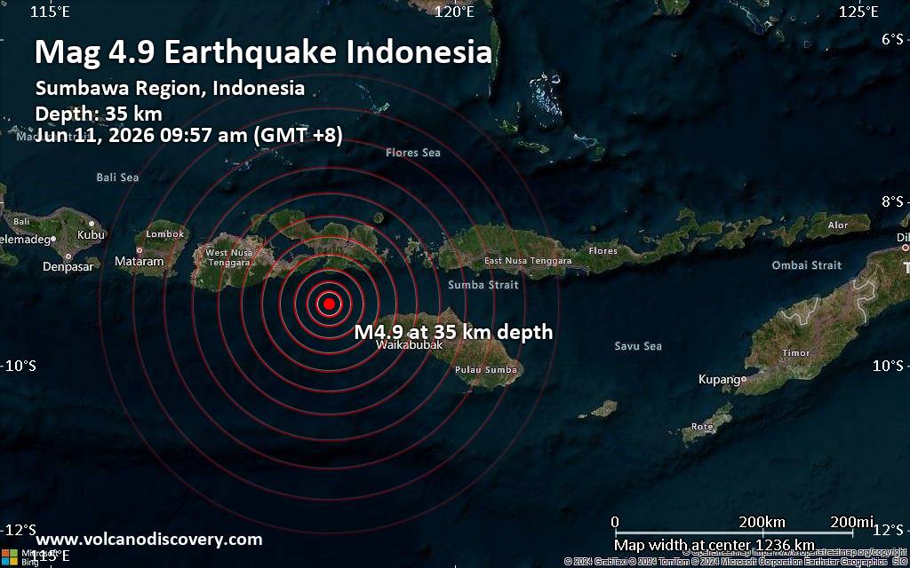 An earthquake of magnitude 4.9 occurred only 12 minutes ago 92 km southwest of Bima, Indonesia, Indonesia's Meteorology, Climatology, and Geophysical Agency reported.
The quake hit at a moderately shallow depth of 35. km beneath the epicenter near Bima, Bima City, West Nusa Tenggara, Indonesia, in the morning on Thursday, June 11th, 2026, at 9:57 am local time. The exact magnitude, epicenter, and depth of the quake might be revised within the next few hours or minutes as seismologists review data and refine their calculations, or as other agencies issue their report.
A second report was later issued by the citizen-seismograph network of RaspberryShake, which listed it as a magnitude 4.9 earthquake as well.
Based on the preliminary seismic data, the quake should not have caused any significant damage, but was probably felt by many people as light vibration in the area of the epicenter.
Weak shaking might have been felt in Dompu (pop. 55,000) located 78 km from the epicenter, Tambolaka (pop. 35,800) 90 km away, Bima (pop. 161,400) 92 km away, and Sape (pop. 5,000) 96 km away.
VolcanoDiscovery will automatically update magnitude and depth if these change and follow up if other significant news about the quake become available. If you’re in the area, please send us your experience through our reporting mechanism, either online or via our mobile app. This will help us provide more first-hand updates to anyone around the globe who wants to know more about this quake.
Earthquake data: Date & time: Jun 11, 2026 09:57 am (GMT +8) local time (11 Jun 2026 01:57 GMT)Magnitude: 4.9 Depth: 35.00 km Epicenter latitude / longitude: 9.24°S / 118.44°E  ( West Nusa Tenggara, Indonesia) Primary data source: BMKGhttps://www.volcanodiscovery.com/earthquake/news/305154/Moderate-magnitude-49-earthquake-92-km-southwest-of-Bima-Indonesia.html
0
2
Read More
|
SPC Severe Thunderstorm Watch 306 Status Reports
Webmaster
3 hours ago
SPC Severe Thunderstorm Watch 306 Status ReportsWW 0306 Status Updates 
STATUS REPORT ON WW 306

SEVERE WEATHER THREAT CONTINUES RIGHT OF A LINE FROM 10 S MIE TO
30 WNW FDY.

WW 306 WILL BE ALLOWED TO EXPIRE AT 110300Z.

..LYONS..06/11/26

ATTN...WFO...IWX...IND...GRR...APX...


STATUS REPORT FOR WS 306

SEVERE WEATHER THREAT CONTINUES FOR THE FOLLOWING AREAS

INC001-075-110300-

IN
.    INDIANA COUNTIES INCLUDED ARE

ADAMS                JAY


MIC113-143-110300-

MI
.    MICHIGAN COUNTIES INCLUDED ARE

MISSAUKEE            ROSCOMMON


OHC161-110300-

OH
.    OHIO COUNTIES INCLUDED ARE

VAN WERT
Read morehttps://www.spc.noaa.gov/products/watch/ws0306.html
0
Read More
|
SPC Tornado Watch 303 Status Reports
Webmaster
3 hours ago
SPC Tornado Watch 303 Status ReportsWW 0303 Status Updates 
STATUS REPORT ON WW 303

SEVERE WEATHER THREAT CONTINUES RIGHT OF A LINE FROM 20 SW SLN TO
30 WSW TOP TO 30 NE EMP TO 20 NNW CNU.

..LYONS..06/11/26

ATTN...WFO...DMX...OAX...EAX...TOP...ICT...


STATUS REPORT FOR WT 303

SEVERE WEATHER THREAT CONTINUES FOR THE FOLLOWING AREAS

IAC007-051-053-117-123-135-179-185-110340-

IA
.    IOWA COUNTIES INCLUDED ARE

APPANOOSE            DAVIS               DECATUR
LUCAS                MAHASKA             MONROE
WAPELLO              WAYNE


KSC017-031-061-079-111-113-115-127-139-159-177-197-110340-

KS
.    KANSAS COUNTIES INCLUDED ARE

CHASE                COFFEY              GEARY
HARVEY               LYON                MCPHERSON
MARION               MORRIS              OSAGE
RICE                 SHAWNEE             WABAUNSEE


MOC001-061-075-079-081-115-117-121-129-171-197-211-227-110340-

MO
.    MISSOURI COUNTIES INCLUDED ARE
Read morehttps://www.spc.noaa.gov/products/watch/ws0303.html
0
Read More
|
SPC Tornado Watch 303
Webmaster
3 hours ago
SPC Tornado Watch 303WW 303 TORNADO IA KS MO NE 101910Z - 110200Z
URGENT - IMMEDIATE BROADCAST REQUESTED
Tornado Watch Number 303
NWS Storm Prediction Center Norman OK
210 PM CDT Wed Jun 10 2026

The NWS Storm Prediction Center has issued a

* Tornado Watch for portions of
  Southern Iowa
  Central and Eastern Kansas
  Northwest and North-Central Missouri
  Extreme Southeast Nebraska

* Effective this Wednesday afternoon and evening from 210 PM
  until 900 PM CDT.

* Primary threats include...
  A few tornadoes likely with a couple intense tornadoes possible
  Scattered damaging winds and isolated significant gusts to 75
    mph likely
  Scattered large hail and isolated very large hail events to 3
    inches in diameter likely

SUMMARY...Thunderstorm development is anticipated this afternoon
within the warm and very unstable airmass across the region.
Deep-layer shear is strong enough for supercells capable of all
hazards, including very large hail to 3" in diameter and tornadoes.
A strong tornado (EF2+) is possible. Strong downbursts are
anticipated as well, with one or more severe bowing clusters
possible as the mode trends more linear with time.

The tornado watch area is approximately along and 60 statute miles
north and south of a line from 45 miles southwest of Manhattan KS to
35 miles south southeast of Ottumwa IA. For a complete depiction of
the watch see the associated watch outline update (WOUS64 KWNS
WOU3).

PRECAUTIONARY/PREPAREDNESS ACTIONS...

REMEMBER...A Tornado Watch means conditions are favorable for
tornadoes and severe thunderstorms in and close to the watch
area. Persons in these areas should be on the lookout for
threatening weather conditions and listen for later statements
and possible warnings.

&&

OTHER WATCH INFORMATION...CONTINUE...WW 301...WW 302...

AVIATION...Tornadoes and a few severe thunderstorms with hail
surface and aloft to 3 inches. Extreme turbulence and surface wind
gusts to 65 knots. A few cumulonimbi with maximum tops to 500. Mean
storm motion vector 24030.

...Mosier
Read morehttps://www.spc.noaa.gov/products/watch/ww0303.html
0
Read More
|
SPC Jun 11, 2026 0100 UTC Day 1 Convective Outlook
Webmaster
3 hours ago
SPC Jun 11, 2026 0100 UTC Day 1 Convective OutlookSPC 0100Z Day 1 Outlook 
Day 1 Convective Outlook
NWS Storm Prediction Center Norman OK
0819 PM CDT Wed Jun 10 2026

Valid 110100Z - 111200Z

...THERE IS AN ENHANCED RISK OF SEVERE THUNDERSTORMS ACROSS PORTIONS
OF THE UPPER MISSISSIPPI VALLEY INTO PARTS OF THE PLAINS...

...SUMMARY...
Scattered to numerous severe thunderstorms with potential for large
hail, a couple of tornadoes and damaging winds with gusts over 75
mph will continue this evening across parts of the Upper Mississippi
Valley and Midwest.

...Synopsis...
A cold front extends from portions of the upper Midwest into the
central Plains, with a surface low over Manitoba. Several lines and
clusters of severe thunderstorms continue along and ahead of this
feature across portions of the Great Lakes into the Midwest and
central/southern Plains. The risk for damaging wind, large hail, and
a couple of tornadoes will continue into the evening across these
regions extending into the Ohio Valley overnight.

...Central Kansas, northwest Missouri and Iowa...
Widespread thunderstorm development continues across central Kansas
into central Iowa along the cold front. Initial development is
supercelluar and pose a risk for large hail, damaging wind, and
perhaps a tornado. Linear forcing along the front will likely lead
to upscale growth, with the primary threat becoming damaging wind.
Ongoing convection further west into southern Iowa/northwest
Missouri is remaining a mixed-mode of supercells and multi-cell
clusters. Within this area, strong instability and deep layer shear
may continue to pose a risk for a tornado or two while storm mode
remains semi-discrete. The 10% tornado risk and 30% hail risk areas
were removed with this update given the tendency for more linear
storm modes.

...Eastern Nebraska/far western Iowa and northern Illinois...
Latest forecast guidance continues to show a signal for elevated
convection near the terminus of a low-level jet across eastern
NE/western IA late tonight/early Thursday morning. Forecast
soundings from these solutions, most notably recent RAP runs and the
NAM, hint that low-level moisture advection may be sufficient to
support parcels rooted near the surface. Initial thunderstorms may
pose a risk for hail before growing upscale into a damaging MCS into
the end of the current D1 period tomorrow morning. A 30% wind area
was introduced into southeastern Nebraska/southern Iowa in support
of recent HRRR runs which show potential for a swath of damaging
wind across far eastern Nebraska into southern Iowa.

..Thornton.. 06/11/2026
Read morehttps://www.spc.noaa.gov/products/outlook/day1otlk_0100.html
0
Read More
|
World Earthquake Report for Wednesday, 10 June 2026
Webmaster
4 hours ago
World Earthquake Report for Wednesday, 10 June 2026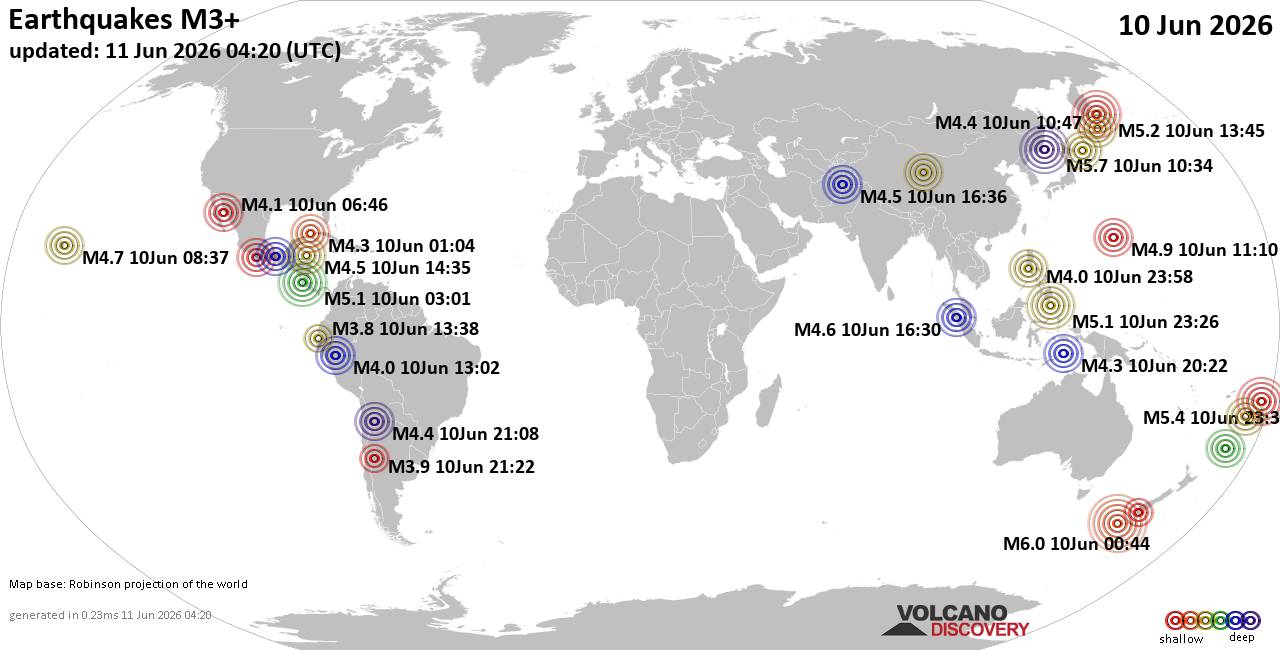 Worldwide earthquakes above magnitude 3 during the past 24 hours on 11 Jun 2026 Magnitude 6+: 1 earthquake Magnitude 5+: 8 earthquakes Magnitude 4+: 66 earthquakes Magnitude 3+: 204 earthquakes Magnitude 2+: 488 earthquakes No quakes of magnitude 7 or higher 10 largest earthquakes in the world (10 Jun 2026)Wednesday, Jun 10, 2026, at 11:44 am (GMT +11) - Wednesday, Jun 10, 2026, at 07:34 pm (GMT +9) - Thursday, Jun 11, 2026, at 12:30 pm (GMT +13) - Thursday, Jun 11, 2026, at 12:45 am (GMT +11) - Tuesday, Jun 9, 2026, at 09:01 pm (Costa Rica time) - Thursday, Jun 11, 2026, at 07:26 am (Makassar time) - Wednesday, Jun 10, 2026, at 05:13 pm (Manila time) - Wednesday, Jun 10, 2026, at 09:54 am (Manila time) - Wednesday, Jun 10, 2026, at 07:07 pm (Manila time) - Wednesday, Jun 10, 2026, at 09:10 pm (GMT +10) - Earthquakes reported feltTuesday, Jun 9, 2026, at 09:01 pm (Costa Rica time) - Tuesday, Jun 9, 2026, at 10:37 pm (GMT -10) - Wednesday, Jun 10, 2026, at 04:25 pm (GMT -7) - Tuesday, Jun 9, 2026, at 08:29 pm (GMT -7) - Wednesday, Jun 10, 2026, at 09:54 am (Manila time) - Wednesday, Jun 10, 2026, at 07:44 am (GMT -4) - Wednesday, Jun 10, 2026, at 05:13 pm (Manila time) - Wednesday, Jun 10, 2026, at 11:44 am (GMT +11) - Thursday, Jun 11, 2026, at 01:45 am (GMT +3) - Wednesday, Jun 10, 2026, at 07:34 pm (GMT +9) - Tuesday, Jun 9, 2026, at 07:13 pm (GMT -6) - Thursday, Jun 11, 2026, at 12:45 am (GMT +11) - Wednesday, Jun 10, 2026, at 05:36 pm (GMT -6) - Thursday, Jun 11, 2026, at 01:52 am (GMT +3) - Tuesday, Jun 9, 2026, at 11:21 pm (GMT -3) - Thursday, Jun 11, 2026, at 07:58 am (GMT +8) - Thursday, Jun 11, 2026, at 01:25 am (GMT +9) - Wednesday, Jun 10, 2026, at 09:03 am (GMT +8) - Wednesday, Jun 10, 2026, at 08:17 pm (GMT +8) - Wednesday, Jun 10, 2026, at 03:24 pm (GMT +8) - Wednesday, Jun 10, 2026, at 11:37 am (GMT -6) - Earthquake stats  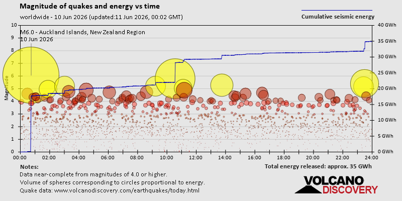 https://www.volcanodiscovery.com/earthquake/news/305100/World-Earthquake-Report-for-Wednesday-10-June-2026.html https://www.volcanodiscovery.com/earthquake/news/305100/World-Earthquake-Report-for-Wednesday-10-June-2026.html
0
4
Read More
|
|
Forums60
Topics780,343
Posts815,101
Members2,960
| |
Most Online22,463
May 9th, 2026
|
|
|
|
|
Copyright 1996 - 2026 by David Cottle. Designed by David Bate Jr. All Rights Reserved.
By using this forum, the user agrees not to transfer any data or technical information received under this agreement to any other entity without the express approval of the AUS-CITY Forum Admins and/or authors of individual posts (Forum Admins and DoD/USSPACECOM for the analysis of satellite tracking data).
Two-line elements (TLE) and all other satellite data presented and distributed via this forum and AUS-CITY mailing lists are distributed with permission from DoD/USSTRATCOM.


|

|


 - Click image for larger picture.")


