|
|
|
0 members (),
1,129
guests, and
39
robots. |
|
Key:
Admin,
Global Mod,
Mod
|
|
S |
M |
T |
W |
T |
F |
S |
|
|
|
|
1
|
2
|
3
|
4
|
|
5
|
6
|
7
|
8
|
9
|
10
|
11
|
|
12
|
13
|
14
|
15
|
16
|
17
|
18
|
|
19
|
20
|
21
|
22
|
23
|
24
|
25
|
|
26
|
27
|
28
|
29
|
30
|
31
|
|
|
There are no members with birthdays on this day. |
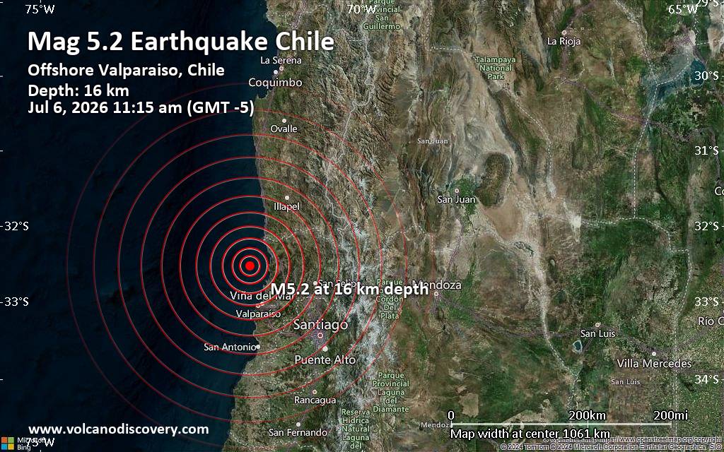
Significant magnitude 5.2 earthquake 58 km north of Valparaiso, Chile
• Small earthquake of magnitude 3.7 just reported 10 km southwest of Glogow, ...
• World Earthquake Report for Monday, 6 July 2026
• Significant 5.3 quake hits near Valparaiso, Provincia de Valparaíso, Regio...
• Moderate mag. 4.6 earthquake - South Pacific Ocean, 45 km north of Valparai...
• Strong mag. 5.2 earthquake - South Pacific Ocean, 58 km north of Valparaiso...
|
 SPC MD 1522
Webmaster
3 hours ago
SPC MD 1522
Webmaster
3 hours ago
SPC MD 1522MD 1522 CONCERNING SEVERE POTENTIAL...SEVERE THUNDERSTORM WATCH LIKELY FOR EASTERN NORTH DAKOTA...NORTHWEST MINNESOTA...NORTHEAST SOUTH DAKOTA 
Mesoscale Discussion 1522
NWS Storm Prediction Center Norman OK
0111 PM CDT Mon Jul 06 2026

Areas affected...Eastern North Dakota...northwest
Minnesota...northeast South Dakota

Concerning...Severe potential...Severe Thunderstorm Watch likely

Valid 061811Z - 062015Z

Probability of Watch Issuance...80 percent

SUMMARY...Large hail and severe winds are possible with initial
supercells that will eventually grow upscale into a more organized
cluster/MCS. A watch is likely this afternoon.

DISCUSSION...A slow moving cold front continues southeastward within
the northern Plains. Though influence from the shortwave trough in
Canada is minimal, areas of strong heating of and upper 60s to low
70s F dewpoint airmass is allowing cumulus to deepen along parts of
the boundary. Additionally, mid-level convection will move eastward
through the Dakotas and may gradually root near the surface. The
strongest initial development will likely occur along the Canadian
border in northwest Minnesota given the greater surface heating and
nominally greater mid-level ascent. Effective shear of 35-40 kt will
support a mixture of supercells and multicells. With time, linear
forcing along the cold front and cold pool mergers will lead to a
broader linear structure. Initial supercells would be capable of
large hail up to 2 inches. As activity congeals, severe wind
gusts/wind damage would become more likely. The environment into the
Mississippi Valley becomes less favorable. Movement of storms toward
the south/southeast into the greater buoyancy is expected with time.

..Wendt/Hart.. 07/06/2026

...Please see www.spc.noaa.gov for graphic product...

ATTN...WFO...FGF...ABR...BIS...

LAT...LON   45739785 46109810 48279763 49079707 49179637 48959581
            46519627 45859646 45659673 45739785

MOST PROBABLE PEAK TORNADO INTENSITY...UP TO 90 MPH
MOST PROBABLE PEAK WIND GUST...65-80 MPH
MOST PROBABLE PEAK HAIL SIZE...1.50-2.50 IN
Read morehttps://www.spc.noaa.gov/products/md/md1522.html
0
6
Read More
|
SPC MD 1523
Webmaster
3 hours ago
SPC MD 1523MD 1523 CONCERNING SEVERE POTENTIAL...WATCH POSSIBLE FOR MUCH OF NORTHERN/CENTRAL VIRGINIA INTO NORTH-CENTRAL NORTH CAROLINA 
Mesoscale Discussion 1523
NWS Storm Prediction Center Norman OK
0127 PM CDT Mon Jul 06 2026

Areas affected...Much of northern/central Virginia into
north-central North Carolina

Concerning...Severe potential...Watch possible

Valid 061827Z - 062100Z

Probability of Watch Issuance...40 percent

SUMMARY...The area is being monitored for an increase in
thunderstorm development this afternoon. The stronger storms will be
capable of producing damaging wind gusts. It is unclear if a watch
will be needed, especially in the near term.

DISCUSSION...The latest radar data shows a gradual increase in
thunderstorm development over the higher terrain of western VA ,
with more isolated development farther east. Over the next few
hours, continued diurnal heating and orographic lift should promote
scattered thunderstorms. As these storms advance eastward into parts
of central VA and north-central NC, steepening low-level lapse rates
and increasing buoyancy will promote damaging wind gusts --
especially with any clusters of storms that evolve. Current thinking
is that the greater risk of damaging winds will develop later this
afternoon into the evening, as storms congeal into small clusters.
Therefore, the need for a watch is uncertain in the near term,
though convective trends are being monitored.

..Weinman/Hart.. 07/06/2026

...Please see www.spc.noaa.gov for graphic product...

ATTN...WFO...AKQ...LWX...RAH...RNK...

LAT...LON   36578011 37117958 37627924 38217893 38617844 38837801
            38847750 38567704 38247687 37587689 36607735 35727817
            35427881 35437971 35738020 36138031 36578011

MOST PROBABLE PEAK WIND GUST...55-70 MPH
Read morehttps://www.spc.noaa.gov/products/md/md1523.html
0
4
Read More
|
SPC Day 2 Fire Weather Outlook
Webmaster
3 hours ago
SPC Day 2 Fire Weather OutlookSPC Day 2 Fire Weather Outlook 
Day 2 Fire Weather Outlook
NWS Storm Prediction Center Norman OK
0206 PM CDT Mon Jul 06 2026

Valid 071200Z - 081200Z

...Afternoon Update...
Only slight adjustments were made to the risk areas based on the
latest guidance. Notably, the Isolated Dry Thunderstorm risk area
was expanded into southern ID where a mix of wet/dry thunderstorms
will pose a risk for lightning ignitions where pockets of dry fuels
exist. Following dry thunderstorms on Day 1/Monday, dry and windy
conditions on Day 2/Tuesday may encourage possible lightning
holdovers to emerge east of the Cascades (south-central OR) into the
northern Sierra Nevada (northeast CA/northwest NV), and west-central
UT where Elevated highlights were maintained. The rest of the
forecast remains on track, see the previous discussion for more
information.

..Elizalde-Garcia.. 07/06/2026

.PREV DISCUSSION... /ISSUED 0206 AM CDT Mon Jul 06 2026/

...Synopsis...
Fire weather concerns will continue to be driven by a combination of
dry thunderstorm potential as well as dry/windy conditions across
portions of the West on Tuesday. A slight eastward shift of the
upper ridge from the Four Corners into the central Rockies is
expected through Tuesday evening. This will establish a more
west/southwest flow regime across the West Coast that will be
favorable for downslope flow off the northern Sierra Nevada and
portions of the Cascades. Additionally, a plume of mid-level
moisture will continue to spread east/northeast from the western
Great Basin towards the Four Corners/central Rockies that will
promote dry thunderstorm potential across a broad area.

...Dry Thunderstorms...
Mid-level moisture spreading eastward over the next 24 hours will
impinge on a plume of steep mid-level lapse rates and dry
boundary-layer conditions currently in place across the Four Corners
and central Rockies. This should promote adequate buoyancy for weak
convection by Tuesday afternoon. PWAT values are currently forecast
to range from 0.75 inches from the northern Great Basin to around
0.5 inch across UT and western CO. Forcing for ascent driven by weak
perturbations within the mean southwesterly flow regime over the
northern Great Basin should decrease eastward into the Four Corners
were orographic ascent will yield more isolated thunderstorms. This
will likely result in a mix of wet and dry thunderstorms across the
northern Great Basin with increasingly dry thunderstorms with
east/southeastward extent. Portions of central OR were removed from
the risk area owing to the potential for wetting rainfall over the
next 24 hours. However, portions of the area may be at risk for dry
lightning if rainfall amounts are more limited than currently
anticipated.

...Cascades into the northern Sierra Nevada...
The establishment of a southwest flow regime across the Cascades and
northern Sierra Nevada will promote strengthening downslope flow
along the eastern slopes. Latest forecast guidance suggests that the
driest and windiest conditions will emerge across northeast
CA/northwest NV where sustained winds between 15-20 mph will likely
coincide with 10-15% RH minimums. Further north, cooler conditions
will result in more sparse coverage of elevated conditions, but
favored gaps will likely see 15-20 mph winds with RH values falling
into the 15-25% range by late afternoon.

...Eastern Nevada into western Utah...
Another day of dry and windy conditions is expected for Tuesday as
weak troughing across the northern Great Basin drives an uptick in
southwesterly flow across the region. Confidence in 10-15% RH
minimums is fairly high given downslope trajectories off the
southern Sierra Nevada over the preceding 24 hours, and latest
HREF/REFS guidance suggests wind speeds will likely reach 15 mph for
many locations, resulting in a few hours of sustained elevated
conditions.

...Please see www.spc.noaa.gov/fire for graphic product...
Read morehttps://www.spc.noaa.gov/products/fire_wx/fwdy2.html
0
4
Read More
|
SPC Severe Thunderstorm Watch 466
Webmaster
3 hours ago
SPC Severe Thunderstorm Watch 466WW 466 SEVERE TSTM MN ND 061840Z - 070200Z 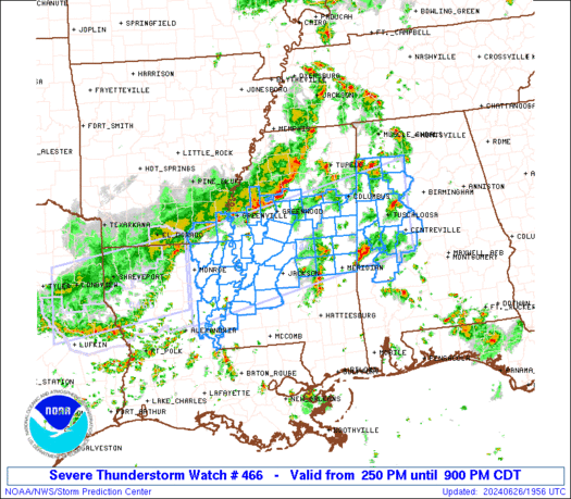
URGENT - IMMEDIATE BROADCAST REQUESTED
Severe Thunderstorm Watch Number 466
NWS Storm Prediction Center Norman OK
140 PM CDT Mon Jul 6 2026

The NWS Storm Prediction Center has issued a

* Severe Thunderstorm Watch for portions of
  Northern Minnesota
  Eastern North Dakota

* Effective this Monday afternoon and evening from 140 PM until
  900 PM CDT.

* Primary threats include...
  Scattered damaging winds and isolated significant gusts to 75
    mph likely
  Scattered large hail and isolated very large hail events to 2
    inches in diameter possible
  A tornado or two possible

SUMMARY...Thunderstorms will intensify this afternoon along and
ahead of a cold front, and build eastward through the watch area.
Large hail and damaging winds will be possible with this activity.

The severe thunderstorm watch area is approximately along and 85
statute miles north and south of a line from 80 miles west of Fargo
ND to 35 miles south southeast of International Falls MN. For a
complete depiction of the watch see the associated watch outline
update (WOUS64 KWNS WOU6).

PRECAUTIONARY/PREPAREDNESS ACTIONS...

REMEMBER...A Severe Thunderstorm Watch means conditions are
favorable for severe thunderstorms in and close to the watch area.
Persons in these areas should be on the lookout for threatening
weather conditions and listen for later statements and possible
warnings. Severe thunderstorms can and occasionally do produce
tornadoes.

&&

AVIATION...A few severe thunderstorms with hail surface and aloft to
2 inches. Extreme turbulence and surface wind gusts to 65 knots. A
few cumulonimbi with maximum tops to 500. Mean storm motion vector
27030.

...Hart
Read morehttps://www.spc.noaa.gov/products/watch/ww0466.html
0
4
Read More
|
|
Forums60
Topics786,980
Posts821,754
Members2,960
| |
Most Online22,463
May 9th, 2026
|
|
|
|
|
Copyright 1996 - 2026 by David Cottle. Designed by David Bate Jr. All Rights Reserved.
By using this forum, the user agrees not to transfer any data or technical information received under this agreement to any other entity without the express approval of the AUS-CITY Forum Admins and/or authors of individual posts (Forum Admins and DoD/USSPACECOM for the analysis of satellite tracking data).
Two-line elements (TLE) and all other satellite data presented and distributed via this forum and AUS-CITY mailing lists are distributed with permission from DoD/USSTRATCOM.



|

|