0 members (),
4,758
guests, and
25
robots.
Key:
Admin ,
Global Mod ,
Mod
S
M
T
W
T
F
S
1
2
3
4
5
6
7
8
9
10
11
12
13
14
15
16
17
18
19
20
21
22
23
24
25
26
27
28
There are no members with birthdays on this day.
Re: invf Pakistan fails to achieve polio-free target in 2018
Anonymous 2 hours ago
Автоматические покупки, моментальная выдача товара, уведомления о статусе заказов и поддержка 24/7.
90
Read More
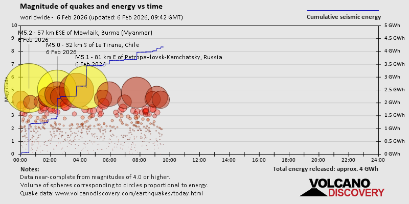
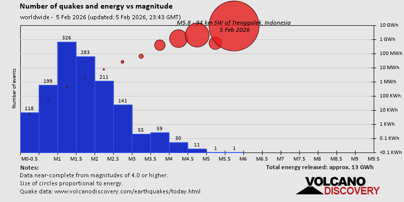
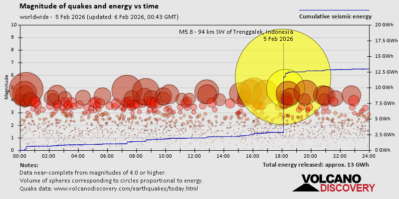
Volcano earthquake report for Friday, 6 Feb 2026
Webmaster 7 hours ago
Volcano earthquake report for Friday, 6 Feb 2026 World map showing volcanoes with shallow (less than 50 km) earthquakes within 20 km radius during the past 24 hours on 6 Feb 2026 Number in brackets indicate nr of quakes.
Quakes detected near: Akita-Yake-yama (7 quakes between mag 0.1-2.6), Askja (2 quakes between mag 0.1-1.2), Batu Tara (1 quake mag 2.6), Brennisteinsfjöll (2 quakes between mag 1.1-1.3), Campi Flegrei (Phlegrean Fields) (1 quake mag 1.2), Clear Lake (30 quakes between mag 0.2-2.0)E-san (1 quake mag 1.3), El Chichón (9 quakes between mag 1.9-3.7), Eldey (1 quake mag 1.2), Hrómundartindur (14 quakes between mag 0.3-1.2), Ililabalekan (1 quake mag 2.5), Katla (11 quakes between mag 0.6-2.7), Katmai (3 quakes between mag 0.1-1.2), Komaga-take (1 quake mag 1.7), Krísuvík (9 quakes between mag 0.0-1.2), Kuchinoshima (1 quake mag 2.2), Kuju (3 quakes between mag 1.1-1.1), Kurikoma (6 quakes between mag 0.7-1.7), Ljósufjöll (6 quakes between mag 0.3-1.1), Loihi (1 quake mag 1.7), Long Valley (2 quakes between mag 0.4-1.0), Lower Chindwin (1 quake mag 4.4), Miyake-shima (1 quake mag 2.2), Mount Adams (2 quakes between mag 1.5-1.8), Ontake-san (4 quakes between mag 0.1-1.0), Prestahnukur (1 quake mag 1.0), Redoubt (1 quake mag 1.3), Sarik-Gajah (1 quake mag 2.3), Svartsengi (3 quakes between mag 0.6-1.2), Tambora (1 quake mag 2.4), Tandikat (1 quake mag 2.0), Tangkubanparahu (1 quake mag 2.8), Taranaki (1 quake mag 3.0), Tjörnes Fracture Zone (3 quakes between mag 0.2-1.9) (updated 05h50) Note: Earthquakes within 20 km from and at depths less than 50 km under active volcanoes are reported. The list is not complete because many volcanoes are not monitored and/or seismic data in high resolution is not available publicly.
Akita-Yake-yama volcano (Honshu): 7 earthquakes up to magnitude 2.6 7 earthquakes occurred near (under) the volcano during 15 hours, the last being recorded quake 7 hours ago. Hypocenter depths ranged between 12.60 and 3.40 km.
Earthquake details: (only 5 largest)
2.6 quake 47 km northeast of Akita, Akita, Japan, Feb 5, 2026 04:43 pm (GMT +9) (19 km W)
2.6 quake 47 km northeast of Akita, Akita, Japan, Feb 5, 2026 04:43 pm (GMT +9) (19 km W)
1.6 quake 47 km northeast of Akita, Akita, Japan, Feb 5, 2026 04:46 pm (GMT +9) (19 km W)
1.3 quake 47 km northeast of Akita, Akita, Japan, Feb 6, 2026 08:05 am (GMT +9) (19 km W)
0.7 quake 47 km northeast of Akita, Akita, Japan, Feb 5, 2026 10:16 pm (GMT +9) (18 km W)
All earthquakes at Akita-Yake-yama Batu Tara volcano (Lesser Sunda Islands): magnitude 2.6 earthquake A magnitude 2.6 earthquake occurred at the volcano 18 hours ago. The quake, which might be volcanic in origin, was located at a depth of 12.00 km depth at 8 km distance SSW from the volcano.
Earthquake details: 2.6 quake Banda Sea, 60 km north of Lewoleba, Indonesia, Feb 5, 2026 08:10 pm (GMT +8) (8 km SSW)
All earthquakes at Batu Tara Clear Lake volcano (California): 30 earthquakes up to magnitude 2.0 Possible earthquake swarm: 30 earthquakes occurred near (under) the volcano during 22 hours, the last being recorded quake 1 hour 17 minutes ago. Hypocenter depths ranged between 10.91 and 1.31 km.
Earthquake details: (only 5 largest)
2.0 quake Sonoma County, 13 mi southwest of Clearlake, Lake County, California, United States, Feb 5, 2026 02:41 am (GMT -8) (16 km S)
1.4 quake Lake County, 27 mi north of Santa Rosa, Sonoma County, California, United States, Feb 5, 2026 12:55 am (GMT -8) (16 km S)
1.1 quake 26 mi north of Santa Rosa, Sonoma County, California, United States, Feb 5, 2026 08:36 am (GMT -8) (18 km SSW)
1.1 quake Lake County, 27 mi north of Santa Rosa, Sonoma County, California, United States, Feb 5, 2026 02:49 am (GMT -8) (16 km S)
1.0 quake Lake County, 26 mi north of Santa Rosa, Sonoma County, California, United States, Feb 5, 2026 05:51 pm (GMT -8) (17 km S)
All earthquakes at Clear Lake El Chichón volcano (Southern Mexico): 9 earthquakes up to magnitude 3.7 9 earthquakes occurred near (under) the volcano during 9 hours, the last being recorded quake 15 hours ago. Hypocenter depths ranged between 19.20 and 2.60 km.
Earthquake details: (only 5 largest)
3.7 quake 64 km north of Tuxtla, Estado de Chiapas, Mexico, Feb 5, 2026 02:24 am (Merida time) (5 km SE)
2.8 quake Estado de Chiapas, 36 km southwest of Teapa, Estado de Tabasco, Mexico, Feb 5, 2026 09:06 am (GMT -6) (1 km N)
2.6 quake Estado de Chiapas, 37 km southwest of Teapa, Estado de Tabasco, Mexico, Feb 5, 2026 12:11 am (GMT -6) (2 km NNW)
2.4 quake Estado de Chiapas, 37 km southwest of Teapa, Estado de Tabasco, Mexico, Feb 5, 2026 02:37 am (GMT -6) (1 km NNW)
2.4 quake Estado de Chiapas, 36 km southwest of Teapa, Estado de Tabasco, Mexico, Feb 5, 2026 03:25 am (GMT -6) (1 km N)
All earthquakes at El Chichón Hrómundartindur volcano (Iceland): 14 earthquakes up to magnitude 1.2 Possible earthquake swarm: 14 earthquakes occurred near (under) the volcano during 22 hours, the last being recorded quake 30 minutes ago. Hypocenter depths ranged between 8.40 and 2.60 km.
Earthquake details: (only 5 largest)
1.2 quake 1.2 km WNW of Hveradalir Feb 6, 2026 05:19 am (Universal Time) (12 km WSW)
1.1 quake 4.1 km SE of Skálafell Feb 5, 2026 07:30 am (Universal Time) (12 km SSW)
1.0 quake Iceland: 0.7 km SW of Hellisheiðarvirkjun Feb 6, 2026 04:44 am (Reykjavik time) (11 km WSW)
0.9 quake 0.9 km ESE of Hellisheiðarvirkjun Feb 6, 2026 04:19 am (Universal Time) (10 km WSW)
0.8 quake Iceland: 0.6 km SW of Hveradalir Feb 6, 2026 04:17 am (Reykjavik time) (12 km WSW)
All earthquakes at Hrómundartindur Ililabalekan volcano (Lesser Sunda Islands): magnitude 2.5 earthquake A magnitude 2.5 earthquake occurred at the volcano 22 hours ago. The quake, which might be volcanic in origin, was located at a depth of 17.00 km depth at 19 km distance SSE from the volcano.
Earthquake details: 2.5 quake Savu Sea, 37 km south of Lewoleba, Indonesia, Feb 5, 2026 03:55 pm (GMT +8) (19 km SSE)
All earthquakes at Ililabalekan Katla volcano (Iceland): 11 earthquakes up to magnitude 2.7 Possible earthquake swarm: 11 earthquakes occurred near (under) the volcano during 15 hours, the last being recorded quake 6 hours ago. Hypocenter depths ranged between 5.60 and 0.00 km.
Earthquake details: (only 5 largest)
2.7 quake Iceland: 2.2 km NNW of Hábunga Feb 5, 2026 06:28 pm (Reykjavik time) (5 km SW)
1.6 quake 5.9 km ENE of Goðabunga Feb 5, 2026 06:38 pm (Universal Time) (6 km NW)
1.4 quake 2.8 km SSW of Goðabunga Feb 5, 2026 09:04 am (Universal Time) (11 km W)
1.3 quake Iceland: 2.8 km SE of Goðabunga Feb 5, 2026 11:50 am (Reykjavik time) (7 km W)
1.1 quake Iceland: 5.7 km E of Goðabunga Feb 5, 2026 06:42 pm (Reykjavik time) (4 km W)
All earthquakes at Katla Kuchinoshima volcano (Ryukyu Islands): magnitude 2.2 earthquake A magnitude 2.2 earthquake occurred at the volcano 19 hours ago. The quake, which might be volcanic in origin, was located at a depth of 9.00 km depth at 7 km distance WSW from the volcano.
Earthquake details: 2.2 quake East China Sea, 8.3 km north of Nakanoshima, Kagoshima-ken, Japan, Feb 5, 2026 07:22 pm (GMT +9) (7 km WSW)
All earthquakes at Kuchinoshima Lower Chindwin volcano (Myanmar): magnitude 4.4 earthquake A magnitude 4.4 earthquake occurred at the volcano 9 hours ago. The quake, which might be volcanic in origin, was located at a depth of 10.00 km depth at 15 km distance NW from the volcano.
Earthquake details: 4.4 quake Namchi, Sikkim, 25 km northwest of Darjiling, Darjiling, West Bengal, India, Feb 6, 2026 02:20 am (Kolkata time) (15 km NW)
All earthquakes at Lower Chindwin Miyake-shima volcano (Izu Islands): magnitude 2.2 earthquake A magnitude 2.2 earthquake occurred at the volcano 17 hours ago. The quake, which might be volcanic in origin, was located at a depth of 12.60 km depth at 15 km distance W from the volcano.
Earthquake details: 2.2 quake Philippine Sea, 25 km southeast of Kozu Shima Island, Tokyo, Japan, Feb 5, 2026 10:06 pm (GMT +9) (15 km W)
All earthquakes at Miyake-shima Sarik-Gajah volcano (Sumatra): magnitude 2.3 earthquake A magnitude 2.3 earthquake occurred at the volcano 23 hours ago. The quake, which might be volcanic in origin, was located at a depth of 5.00 km depth at 12 km distance WNW from the volcano.
Earthquake details: 2.3 quake Kabupaten Pasaman, 57 km northwest of Bukittinggi, Indonesia, Feb 5, 2026 01:31 pm (GMT +7) (12 km WNW)
All earthquakes at Sarik-Gajah Tambora volcano (Sumbawa): magnitude 2.4 earthquake A magnitude 2.4 earthquake occurred at the volcano 17 hours ago. The quake, which might be volcanic in origin, was located at a depth of 8.00 km depth at 16 km distance N from the volcano.
Earthquake details: 2.4 quake Kabupaten Bima, 75 km northeast of Sumbawa Besar, Indonesia, Feb 5, 2026 08:56 pm (GMT +8) (16 km N)
All earthquakes at Tambora Tangkubanparahu volcano (West Java): magnitude 2.8 earthquake A magnitude 2.8 earthquake occurred at the volcano 20 hours ago. The quake, which might be volcanic in origin, was located at a depth of 7.00 km depth at 17 km distance ENE from the volcano.
Earthquake details: 2.8 quake 16 km south of Subang, Kabupaten Subang, Jawa Barat, Indonesia, Feb 5, 2026 04:54 pm (GMT +7) (17 km ENE)
All earthquakes at Tangkubanparahu Taranaki volcano (North Island): magnitude 3.0 earthquake A magnitude 3.0 earthquake occurred at the volcano 3 hours ago. The quake, which might be volcanic in origin, was located at a depth of 10.00 km depth at 19 km distance ESE from the volcano.
Earthquake details: Reported seismic-like event (likely no quake): 27 km north of Hawera, Taranaki, New Zealand, Feb 6, 2026 04:08 pm (GMT +13) (19 km ESE)
All earthquakes at Taranaki https://www.volcanodiscovery.com/earthquakes-volcanoes/news/294036/Volcano-earthquake-report-for-Friday-6-Feb-2026.html
0
Read More
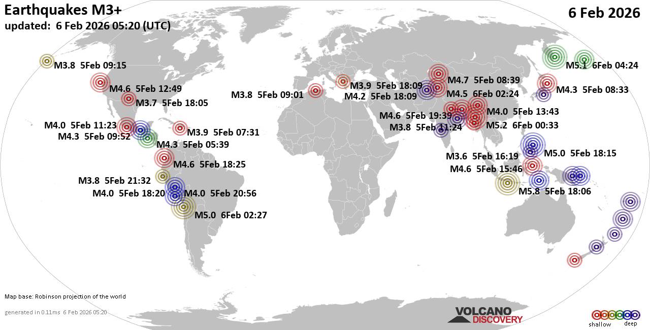
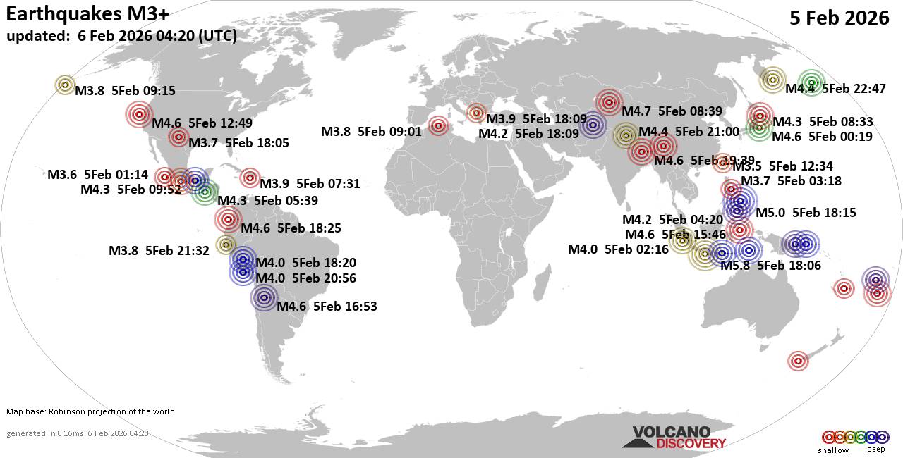
World Earthquake Report for Friday, 6 February 2026
Webmaster 8 hours ago
World Earthquake Report for Friday, 6 February 2026 Worldwide earthquakes above magnitude 3 during the past 24 hours on 6 Feb 2026
Summary: 5 quakes 5.0+, 43 quakes 4.0+, 125 quakes 3.0+, 362 quakes 2.0+ (535 total) This report is being updated every hour. Magnitude
5 +: 5 earthquakes
Magnitude
4 +: 43 earthquakes
Magnitude
3 +: 125 earthquakes
Magnitude
2 +: 362 earthquakes
No quakes of magnitude
6 or higher
10 largest earthquakes in the world (past 24 hours) Friday, Feb 6, 2026, at 01:06 am (GMT +7) -
Friday, Feb 6, 2026, at 07:03 am (Yangon time) -
Friday, Feb 6, 2026, at 04:24 pm (Kamchatka time) -
Thursday, Feb 5, 2026, at 11:27 pm (Santiago time) -
Friday, Feb 6, 2026, at 02:15 am (Manila time) -
Friday, Feb 6, 2026, at 12:44 am (La Rioja time) -
Thursday, Feb 5, 2026, at 05:21 pm (Port Moresby time) -
Friday, Feb 6, 2026, at 04:05 am (Fiji time) -
Thursday, Feb 5, 2026, at 01:39 pm (Almaty time) -
Thursday, Feb 5, 2026, at 11:46 pm (GMT +8) -
Earthquakes reported felt Thursday, Feb 5, 2026, at 12:53 pm (GMT -7) -
Friday, Feb 6, 2026, at 01:09 am (Kolkata time) -
Friday, Feb 6, 2026, at 01:06 am (GMT +7) -
Wednesday, Feb 4, 2026, at 11:39 pm (GMT -6) -
Friday, Feb 6, 2026, at 01:10 am (GMT +7) -
Thursday, Feb 5, 2026, at 11:27 pm (Santiago time) -
Friday, Feb 6, 2026, at 01:11 am (GMT +7) -
Thursday, Feb 5, 2026, at 11:05 am (Denver time) -
Friday, Feb 6, 2026, at 04:24 pm (Kamchatka time) -
Friday, Feb 6, 2026, at 01:15 am (Kolkata time) -
Thursday, Feb 5, 2026, at 10:01 am (Algiers time) -
Friday, Feb 6, 2026, at 02:20 am (Kolkata time) -
Thursday, Feb 5, 2026, at 04:49 am (GMT -8) -
Friday, Feb 6, 2026, at 03:11 am (Kolkata time) -
Friday, Feb 6, 2026, at 07:03 am (Yangon time) -
Thursday, Feb 5, 2026, at 01:39 pm (Almaty time) -
Thursday, Feb 5, 2026, at 07:45 pm (GMT +2) -
Wednesday, Feb 4, 2026, at 09:59 pm (GMT -8) -
Friday, Feb 6, 2026, at 12:44 am (La Rioja time) -
Friday, Feb 6, 2026, at 12:58 am (GMT +7) -
Thursday, Feb 5, 2026, at 10:07 pm (GMT +1) -
Thursday, Feb 5, 2026, at 03:12 pm (GMT -8) -
Thursday, Feb 5, 2026, at 03:59 pm (GMT -8) -
Thursday, Feb 5, 2026, at 07:03 am (GMT +1) -
Thursday, Feb 5, 2026, at 09:27 am (Mexico City time) -
Thursday, Feb 5, 2026, at 03:54 pm (GMT +1) -
Thursday, Feb 5, 2026, at 01:25 pm (GMT -5) -
Thursday, Feb 5, 2026, at 04:32 pm (Lima time) -
Friday, Feb 6, 2026, at 01:16 am (GMT +7) -
Thursday, Feb 5, 2026, at 02:01 pm (GMT -8) -
Thursday, Feb 5, 2026, at 11:27 pm (GMT +7) -
Friday, Feb 6, 2026, at 02:15 am (Manila time) -
Thursday, Feb 5, 2026, at 08:02 pm (GMT +2) -
Earthquake stats https://www.volcanodiscovery.com/earthquake/news/294045/World-Earthquake-Report-for-Friday-6-February-2026.html
0
Read More
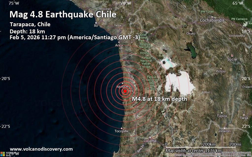
Moderate magnitude 4.8 quake hits 37 km southeast of Iquique, Chile late at night
Webmaster 10 hours ago
Moderate magnitude 4.8 quake hits 37 km southeast of Iquique, Chile late at night
An earthquake of magnitude 4.8 occurred only 15 minutes ago 37 km southeast of Iquique, Chile, the European-Mediterranean Seismological Centre (EMSC) reported.online or via our mobile app . This will help us provide more first-hand updates to anyone around the globe who wants to know more about this quake.
Earthquake data: Date & time: Feb 5, 2026 11:27 pm (Santiago time) local time
(6 Feb 2026 02:27 GMT) Magnitude: 4.8
Depth: 18.30 km
Epicenter latitude / longitude: 20.53°S / 70.04°W
(
Provincia de Iquique ,
Tarapacá ,
Chile )
Primary data source:
EMSC https://www.volcanodiscovery.com/earthquake/news/294039/Moderate-magnitude-48-quake-hits-37-km-southeast-of-Iquique-Chile-late-at-night-.html
0
Read More
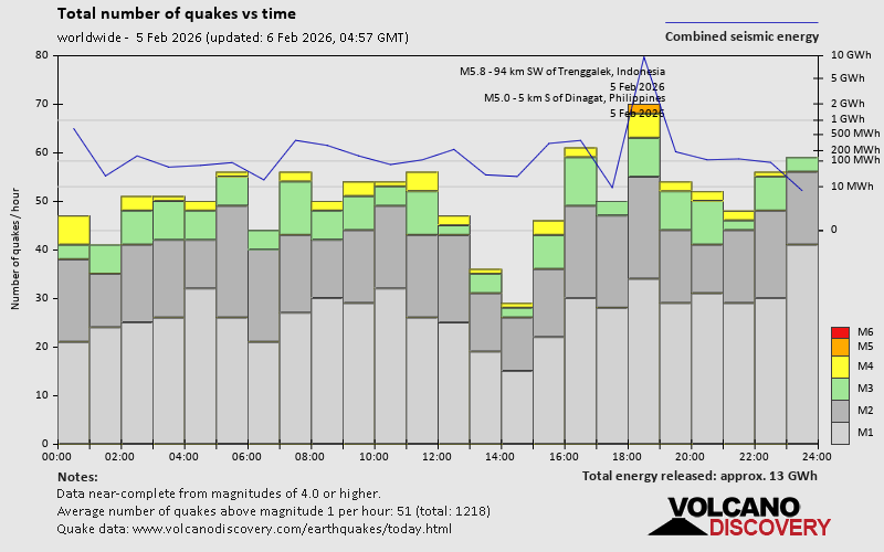
World Earthquake Report for Thursday, 5 February 2026
Webmaster 13 hours ago
World Earthquake Report for Thursday, 5 February 2026 Worldwide earthquakes above magnitude 3 during the past 24 hours on 6 Feb 2026
Summary: 2 quakes 5.0+, 46 quakes 4.0+, 142 quakes 3.0+, 376 quakes 2.0+ (566 total) Magnitude
5 +: 2 earthquakes
Magnitude
4 +: 46 earthquakes
Magnitude
3 +: 142 earthquakes
Magnitude
2 +: 376 earthquakes
No quakes of magnitude
6 or higher
10 largest earthquakes in the world (5 Feb 2026) Friday, Feb 6, 2026, at 01:06 am (GMT +7) -
Friday, Feb 6, 2026, at 02:15 am (Manila time) -
Thursday, Feb 5, 2026, at 01:25 pm (GMT +13) -
Thursday, Feb 5, 2026, at 05:21 pm (Port Moresby time) -
Friday, Feb 6, 2026, at 04:05 am (Fiji time) -
Thursday, Feb 5, 2026, at 01:39 pm (Almaty time) -
Thursday, Feb 5, 2026, at 11:46 pm (GMT +8) -
Thursday, Feb 5, 2026, at 09:19 am (GMT +9) -
Thursday, Feb 5, 2026, at 04:49 am (GMT -8) -
Thursday, Feb 5, 2026, at 01:53 pm (Salta time) -
Earthquakes reported felt Thursday, Feb 5, 2026, at 12:53 pm (GMT -7) -
Friday, Feb 6, 2026, at 01:09 am (Kolkata time) -
Friday, Feb 6, 2026, at 01:06 am (GMT +7) -
Wednesday, Feb 4, 2026, at 11:39 pm (GMT -6) -
Thursday, Feb 5, 2026, at 03:54 am (GMT +1) -
Friday, Feb 6, 2026, at 01:10 am (GMT +7) -
Thursday, Feb 5, 2026, at 09:19 am (GMT +9) -
Friday, Feb 6, 2026, at 01:11 am (GMT +7) -
Thursday, Feb 5, 2026, at 11:05 am (Denver time) -
Friday, Feb 6, 2026, at 01:15 am (Kolkata time) -
Thursday, Feb 5, 2026, at 10:01 am (Algiers time) -
Friday, Feb 6, 2026, at 02:20 am (Kolkata time) -
Thursday, Feb 5, 2026, at 04:49 am (GMT -8) -
Thursday, Feb 5, 2026, at 07:45 pm (GMT +2) -
Thursday, Feb 5, 2026, at 01:39 pm (Almaty time) -
Friday, Feb 6, 2026, at 03:11 am (Kolkata time) -
Wednesday, Feb 4, 2026, at 09:59 pm (GMT -8) -
Wednesday, Feb 4, 2026, at 06:42 pm (Mexico City time) -
Friday, Feb 6, 2026, at 12:58 am (GMT +7) -
Thursday, Feb 5, 2026, at 01:01 am (GMT +1) -
Thursday, Feb 5, 2026, at 10:07 pm (GMT +1) -
Thursday, Feb 5, 2026, at 01:17 am (GMT +1) -
Wednesday, Feb 4, 2026, at 06:24 pm (Mexico City time) -
Thursday, Feb 5, 2026, at 07:03 am (GMT +1) -
Thursday, Feb 5, 2026, at 11:18 am (Manila time) -
Thursday, Feb 5, 2026, at 03:54 pm (GMT +1) -
Thursday, Feb 5, 2026, at 01:25 pm (GMT -5) -
Thursday, Feb 5, 2026, at 03:12 pm (GMT -8) -
Thursday, Feb 5, 2026, at 09:27 am (Mexico City time) -
Thursday, Feb 5, 2026, at 03:59 pm (GMT -8) -
Thursday, Feb 5, 2026, at 02:38 am (GMT +1) -
Thursday, Feb 5, 2026, at 04:32 pm (Lima time) -
Thursday, Feb 5, 2026, at 02:01 pm (GMT -8) -
Friday, Feb 6, 2026, at 01:16 am (GMT +7) -
Thursday, Feb 5, 2026, at 11:27 pm (GMT +7) -
Friday, Feb 6, 2026, at 02:15 am (Manila time) -
Thursday, Feb 5, 2026, at 08:02 pm (GMT +2) -
Thursday, Feb 5, 2026, at 03:31 am (GMT +1) -
Thursday, Feb 5, 2026, at 12:05 am (Santiago time) -
Earthquake stats https://www.volcanodiscovery.com/earthquake/news/293932/World-Earthquake-Report-for-Thursday-5-February-2026.html
0
Read More
Volcano earthquake report for Thursday, 5 Feb 2026
Webmaster Yesterday at 11:50 PM
Volcano earthquake report for Thursday, 5 Feb 2026 World map showing volcanoes with shallow (less than 50 km) earthquakes within 20 km radius during the past 24 hours on 5 Feb 2026 Number in brackets indicate nr of quakes.
Quakes detected near: Akita-Yake-yama (7 quakes between mag 0.1-2.6), Askja (2 quakes between mag 0.1-1.2), Bardarbunga (1 quake mag 1.4), Batu Tara (1 quake mag 2.6), Brennisteinsfjöll (2 quakes between mag 1.0-1.1), Campi Flegrei (Phlegrean Fields) (3 quakes between mag 0.4-1.7)Clear Lake (33 quakes between mag 0.2-2.3), E-san (1 quake mag 1.3), El Chichón (10 quakes between mag 1.9-3.7), Gareloi (2 quakes between mag 0.5-1.0), Hrómundartindur (6 quakes between mag 0.2-1.1), Ililabalekan (1 quake mag 2.5), Katla (10 quakes between mag 0.6-2.7), Katmai (1 quake mag 1.2), Kerlingarfjöll (3 quakes between mag 0.4-2.0), Komaga-take (1 quake mag 1.7), Krísuvík (10 quakes between mag 0.0-1.2), Kuchinoshima (1 quake mag 2.2), Kuju (3 quakes between mag 1.1-1.1), Kurikoma (7 quakes between mag 0.7-1.7), Ljósufjöll (3 quakes between mag 0.4-1.2), Loihi (1 quake mag 1.7), Long Valley (2 quakes between mag 0.4-1.0), Lower Chindwin (1 quake mag 4.4), Miyake-shima (1 quake mag 2.2), Mount Adams (1 quake mag 1.5), Ontake-san (4 quakes between mag 0.1-1.0), Prestahnukur (2 quakes between mag 0.7-1.0), Redoubt (1 quake mag 1.3), Sarik-Gajah (1 quake mag 2.3), Svartsengi (5 quakes between mag 0.1-1.4), Tambora (1 quake mag 2.4), Tana (1 quake mag 1.7), Tandikat (1 quake mag 2.0), Tangkubanparahu (1 quake mag 2.8), Tenerife (1 quake mag 1.3), Yellowstone (2 quakes between mag 1.4-1.6) (updated 23h50) Note: Earthquakes within 20 km from and at depths less than 50 km under active volcanoes are reported. The list is not complete because many volcanoes are not monitored and/or seismic data in high resolution is not available publicly.
Akita-Yake-yama volcano (Honshu): 7 earthquakes up to magnitude 2.6 7 earthquakes occurred near (under) the volcano during 10 hours, the last being recorded quake 11 hours ago. Hypocenter depths ranged between 12.60 and 2.20 km.
Earthquake details: (only 5 largest)
2.6 quake 47 km northeast of Akita, Akita, Japan, Feb 5, 2026 04:43 pm (GMT +9) (19 km W)
2.6 quake 47 km northeast of Akita, Akita, Japan, Feb 5, 2026 04:43 pm (GMT +9) (19 km W)
1.6 quake 47 km northeast of Akita, Akita, Japan, Feb 5, 2026 04:46 pm (GMT +9) (19 km W)
1.1 quake 46 km northeast of Akita, Akita, Japan, Feb 5, 2026 12:46 pm (GMT +9) (19 km W)
0.7 quake 47 km northeast of Akita, Akita, Japan, Feb 5, 2026 10:16 pm (GMT +9) (18 km W)
All earthquakes at Akita-Yake-yama Batu Tara volcano (Lesser Sunda Islands): magnitude 2.6 earthquake A magnitude 2.6 earthquake occurred at the volcano 12 hours ago. The quake, which might be volcanic in origin, was located at a depth of 12.00 km depth at 8 km distance SSW from the volcano.
Earthquake details: 2.6 quake Banda Sea, 60 km north of Lewoleba, Indonesia, Feb 5, 2026 08:10 pm (GMT +8) (8 km SSW)
All earthquakes at Batu Tara Clear Lake volcano (California): 33 earthquakes up to magnitude 2.3 Possible earthquake swarm: 33 earthquakes occurred near (under) the volcano during 23 hours, the last being recorded quake 35 minutes ago. Hypocenter depths ranged between 13.25 and 1.27 km.
Earthquake details: (only 5 largest)
2.3 quake Sonoma County, 13 mi southwest of Clearlake, Lake County, California, United States, Feb 4, 2026 07:45 pm (GMT -8) (16 km SSW)
2.0 quake Sonoma County, 13 mi southwest of Clearlake, Lake County, California, United States, Feb 5, 2026 02:41 am (GMT -8) (16 km S)
1.4 quake Lake County, 27 mi north of Santa Rosa, Sonoma County, California, United States, Feb 5, 2026 12:55 am (GMT -8) (16 km S)
1.1 quake Lake County, 27 mi north of Santa Rosa, Sonoma County, California, United States, Feb 5, 2026 02:49 am (GMT -8) (16 km S)
1.1 quake 26 mi north of Santa Rosa, Sonoma County, California, United States, Feb 5, 2026 08:36 am (GMT -8) (18 km SSW)
All earthquakes at Clear Lake El Chichón volcano (Southern Mexico): 10 earthquakes up to magnitude 3.7 10 earthquakes occurred near (under) the volcano during 4 hours, the last being recorded quake 14 hours ago. Hypocenter depths ranged between 19.20 and 2.60 km.
Earthquake details: (only 5 largest)
3.7 quake 64 km north of Tuxtla, Estado de Chiapas, Mexico, Feb 5, 2026 02:24 am (GMT -6) (5 km SE)
2.7 quake Estado de Chiapas, 36 km southwest of Teapa, Estado de Tabasco, Mexico, Feb 4, 2026 11:13 pm (GMT -6) (1 km N)
2.6 quake Estado de Chiapas, 37 km southwest of Teapa, Estado de Tabasco, Mexico, Feb 5, 2026 12:11 am (GMT -6) (2 km NNW)
2.4 quake Estado de Chiapas, 37 km southwest of Teapa, Estado de Tabasco, Mexico, Feb 5, 2026 02:37 am (GMT -6) (1 km NNW)
2.4 quake Estado de Chiapas, 36 km southwest of Teapa, Estado de Tabasco, Mexico, Feb 5, 2026 03:25 am (GMT -6) (1 km N)
All earthquakes at El Chichón Ililabalekan volcano (Lesser Sunda Islands): magnitude 2.5 earthquake A magnitude 2.5 earthquake occurred at the volcano 16 hours ago. The quake, which might be volcanic in origin, was located at a depth of 17.00 km depth at 19 km distance SSE from the volcano.
Earthquake details: 2.5 quake Savu Sea, 37 km south of Lewoleba, Indonesia, Feb 5, 2026 03:55 pm (GMT +8) (19 km SSE)
All earthquakes at Ililabalekan Katla volcano (Iceland): 10 earthquakes up to magnitude 2.7 10 earthquakes occurred near (under) the volcano during 11 hours, the last being recorded quake 4 hours ago. Hypocenter depths ranged between 5.60 and 0.00 km.
Earthquake details: (only 5 largest)
2.7 quake Iceland: 2.2 km NNW of Hábunga Feb 5, 2026 06:28 pm (Reykjavik time) (5 km SW)
1.6 quake 5.9 km ENE of Goðabunga Feb 5, 2026 06:38 pm (Universal Time) (6 km NW)
1.4 quake 2.8 km SSW of Goðabunga Feb 5, 2026 09:04 am (Universal Time) (11 km W)
1.3 quake Iceland: 2.8 km SE of Goðabunga Feb 5, 2026 11:50 am (Reykjavik time) (7 km W)
1.1 quake Iceland: 5.7 km E of Goðabunga Feb 5, 2026 06:42 pm (Reykjavik time) (4 km W)
All earthquakes at Katla Kuchinoshima volcano (Ryukyu Islands): magnitude 2.2 earthquake A magnitude 2.2 earthquake occurred at the volcano 13 hours ago. The quake, which might be volcanic in origin, was located at a depth of 9.00 km depth at 7 km distance WSW from the volcano.
Earthquake details: 2.2 quake East China Sea, 8.3 km north of Nakanoshima, Kagoshima-ken, Japan, Feb 5, 2026 07:22 pm (GMT +9) (7 km WSW)
All earthquakes at Kuchinoshima Lower Chindwin volcano (Myanmar): magnitude 4.4 earthquake A magnitude 4.4 earthquake occurred at the volcano 3 hours ago. The quake, which might be volcanic in origin, was located at a depth of 10.00 km depth at 15 km distance NW from the volcano.
Earthquake details: 4.4 quake Namchi, Sikkim, 25 km northwest of Darjiling, Darjiling, West Bengal, India, Feb 6, 2026 02:20 am (Kolkata time) (15 km NW)
All earthquakes at Lower Chindwin Miyake-shima volcano (Izu Islands): magnitude 2.2 earthquake A magnitude 2.2 earthquake occurred at the volcano 11 hours ago. The quake, which might be volcanic in origin, was located at a depth of 12.60 km depth at 15 km distance W from the volcano.
Earthquake details: 2.2 quake Philippine Sea, 25 km southeast of Kozu Shima Island, Tokyo, Japan, Feb 5, 2026 10:06 pm (GMT +9) (15 km W)
All earthquakes at Miyake-shima Sarik-Gajah volcano (Sumatra): magnitude 2.3 earthquake A magnitude 2.3 earthquake occurred at the volcano 17 hours ago. The quake, which might be volcanic in origin, was located at a depth of 5.00 km depth at 12 km distance WNW from the volcano.
Earthquake details: 2.3 quake Kabupaten Pasaman, 57 km northwest of Bukittinggi, Indonesia, Feb 5, 2026 01:31 pm (GMT +7) (12 km WNW)
All earthquakes at Sarik-Gajah Tambora volcano (Sumbawa): magnitude 2.4 earthquake A magnitude 2.4 earthquake occurred at the volcano 11 hours ago. The quake, which might be volcanic in origin, was located at a depth of 8.00 km depth at 16 km distance N from the volcano.
Earthquake details: 2.4 quake Kabupaten Bima, 75 km northeast of Sumbawa Besar, Indonesia, Feb 5, 2026 08:56 pm (GMT +8) (16 km N)
All earthquakes at Tambora Tangkubanparahu volcano (West Java): magnitude 2.8 earthquake A magnitude 2.8 earthquake occurred at the volcano 14 hours ago. The quake, which might be volcanic in origin, was located at a depth of 7.00 km depth at 17 km distance ENE from the volcano.
Earthquake details: 2.8 quake 16 km south of Subang, Kabupaten Subang, Jawa Barat, Indonesia, Feb 5, 2026 04:54 pm (GMT +7) (17 km ENE)
All earthquakes at Tangkubanparahu https://www.volcanodiscovery.com/earthquakes-volcanoes/news/293916/Volcano-earthquake-report-for-Thursday-5-Feb-2026.html
0
Read More
Effects of Back-to-Back Winter Storms over Eastern U.S. and the Bahamas
Webmaster Yesterday at 08:31 PM
Effects of Back-to-Back Winter Storms over Eastern U.S. and the Bahamas Effects of Back-to-Back Winter Storms over Eastern U.S. and the Bahamas mwong4 Thu, 02/05/2026 - 15:31
Effects of Back-to-Back Winter Storms over Eastern U.S. and the Bahamas Image captured February 2, 2026, by the VIIRS instrument aboard the joint NASA/NOAA Suomi NPP platform.
Back-to-back winter storms brought snow and ice to the Mid-Atlantic region of the United States and also stirred up sediments in the ocean off the Outer Banks of North Carolina and around the Bahamas. This image from Feb. 2, 2026, was acquired by the Visible Infrared Imaging Radiometer Suite (VIIRS ) aboard the joint NASA/NOAA Suomi National Polar-orbiting Partnership (Suomi NPP ) platform.
This Feb. 2 false-color image, also from the VIIRS/Suomi NPP platform, shows the extent of the snow and ice in bright red from two storms that occurred one week apart.
The winds of the cold wave created linear cloud streets over the ocean. These chilling winds created the bright blue-white suspension of shallow water sediments in the Bahamas, and browner sands and muds stirred up around Florida.
Visit Worldview to visualize near real-time imagery and historical imagery from NASA's Earth Science Data and Information System (ESDIS ); find more imagery in our Worldview weekly image archive .
https://www.earthdata.nasa.gov/news/worldview-image-archive/effects-back-back-winter-storms-over-eastern-u.s.-bahamas
0
Read More
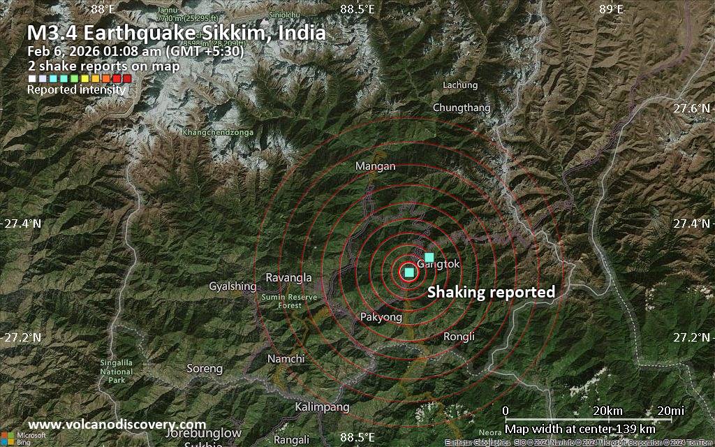
Seismic-like event, possible earthquake, reported few minutes ago near Gangtok, Sikkim, India
Webmaster Yesterday at 07:42 PM
Seismic-like event, possible earthquake, reported few minutes ago near Gangtok, Sikkim, India Unconfirmed quake or seismic-like event reported: 1.6 km southwest of Gangtok, Gangtok, Sikkim, India, 4 minutes ago
We are receiving unverified early reports of ground shaking possibly caused by seismic activity in or near Gangtok, Sikkim, India on 5 Feb 2026 (GMT) at approximately 19:38 GMT.
Earthquake data: Date & time: Feb 6, 2026 01:08 am (GMT +5:30) local time
(5 Feb 2026 19:38 GMT) Magnitude: unspecified
Depth: unspecified
Epicenter latitude / longitude: 27.32°N / 88.6°E
(
Sikkim ,
India )
Primary data source:
VolcanoDiscovery https://www.volcanodiscovery.com/earthquake/news/294020/Seismic-like-event-possible-earthquake-reported-few-minutes-ago-near-Gangtok-Sikkim-India.html
0
Read More
Saturday: Light Rain, Minimum Temperature: 7°C (44°F) Maximum Temperature: 10°C (50°F)
Webmaster Yesterday at 07:01 PM
Maximum Temperature: 10°C (50°F), Minimum Temperature: 7°C (44°F), Wind Direction: easterly, Wind Speed: 6mph, Visibility: Good, Pressure: 993mb, Humidity: 86%, UV Risk: 1, Pollution: Low, Sunrise: 07:44 GMT, Sunset: 17:03 GMT
Source:
Saturday: Light Rain, Minimum Temperature: 7°C (44°F) Maximum Temperature: 10°C (50°F)
0
Read More
Friday: Light Rain, Minimum Temperature: 6°C (42°F) Maximum Temperature: 8°C (46°F)
Webmaster Yesterday at 07:01 PM
Maximum Temperature: 8°C (46°F), Minimum Temperature: 6°C (42°F), Wind Direction: north-easterly, Wind Speed: 11mph, Visibility: Moderate, Pressure: 987mb, Humidity: 85%, UV Risk: 1, Pollution: Low, Sunrise: 07:46 GMT, Sunset: 17:01 GMT
Source:
Friday: Light Rain, Minimum Temperature: 6°C (42°F) Maximum Temperature: 8°C (46°F)
0
Read More
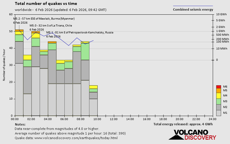
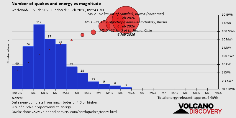
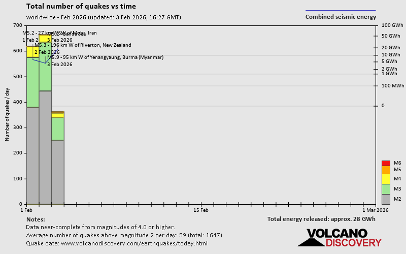
World Earthquake Report for February 2026
Webmaster Yesterday at 07:00 PM
World Earthquake Report for February 2026 Worldwide earthquakes above magnitude 5.5 during February 2026
Summary: 1 quake 6.0+, 19 quakes 5.0+, 185 quakes 4.0+, 803 quakes 3.0+, 1922 quakes 2.0+ (2930 total) This report is being updated every day. Magnitude
9 +: none
Magnitude
8 +: none
Magnitude
7 +: none
Magnitude
6 +: 1 earthquake
Magnitude
5 +: 19 earthquakes
Magnitude
4 +: 185 earthquakes
Magnitude
3 +: 803 earthquakes
Magnitude
2 +: 1922 earthquakes
No quakes of magnitude
7 or higher
List of 10 largest earthquakes in the world during February 2026: Wednesday, Feb 4, 2026, at 11:39 pm (GMT +13) -
Friday, Feb 6, 2026, at 01:06 am (GMT +7) -
Tuesday, Feb 3, 2026, at 10:04 pm (Yangon time) -
Thursday, Feb 5, 2026, at 03:20 am (GMT +9) -
Earthquake stats: https://www.volcanodiscovery.com/view_news/293689/World-Earthquake-Report-for-February-2026.html
0
Read More
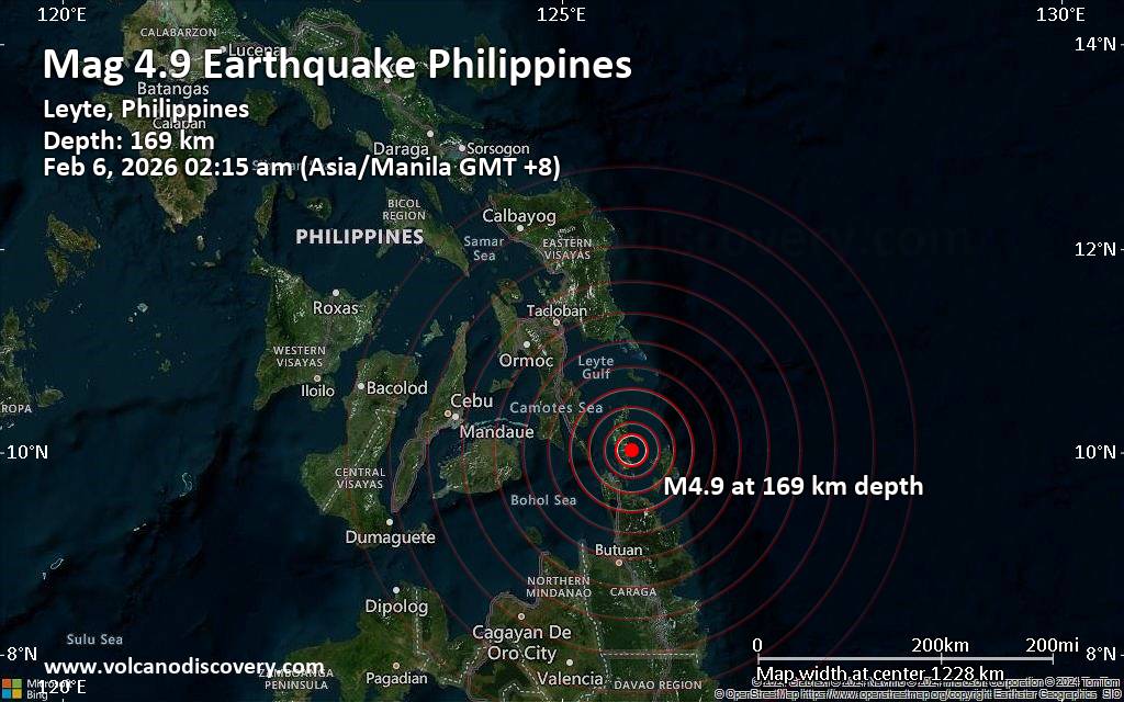
Magnitude 4.9 earthquake strikes near Surigao, Surigao del Norte, Caraga, Philippines
Webmaster Yesterday at 06:31 PM
Magnitude 4.9 earthquake strikes near Surigao, Surigao del Norte, Caraga, Philippines
Just 15 minutes ago, a 4.9-magnitude earthquake struck near Surigao, Surigao del Norte, Caraga, Philippines. The tremor was recorded early morning on Friday, February 6th, 2026, at 2:15 am local time, at an intermediate to considerable depth of 169. km below the surface.online or via our mobile app . This will help us provide more first-hand updates to anyone around the globe who wants to know more about this quake.
Earthquake data: Date & time: Feb 5, 2026 06:15 pm (Universal Time) local time
(5 Feb 2026 18:15 GMT) Magnitude: 5.1
Depth: 172.00 km
Epicenter latitude / longitude: 9.81°N / 125.62°E
(Dinagat Islands,
Caraga ,
Philippines )
Primary data source:
GFZ https://www.volcanodiscovery.com/earthquake/news/294014/Magnitude-49-earthquake-strikes-near-Surigao-Surigao-del-Norte-Caraga-Philippines.html
0
Read More
Forums60
Topics760,405
Posts795,127
Members2,957
Most Online17,963Jan 15th, 2026
Copyright 1996 - 2026 by David Cottle. Designed by David Bate Jr. All Rights Reserved. Reprise Hosting


 (
(

 (
(
 (Dinagat Islands,


 - Click image for larger picture.")


