|
|
|
0 members (),
2,214
guests, and
23
robots. |
|
Key:
Admin,
Global Mod,
Mod
|
|
S |
M |
T |
W |
T |
F |
S |
|
|
|
|
|
1
|
2
|
3
|
|
4
|
5
|
6
|
7
|
8
|
9
|
10
|
|
11
|
12
|
13
|
14
|
15
|
16
|
17
|
|
18
|
19
|
20
|
21
|
22
|
23
|
24
|
|
25
|
26
|
27
|
28
|
29
|
30
|
31
|
|
There are no members with birthdays on this day. |
 SPC Jan 12, 2026 0600 UTC Day 1 Convective Outlook
Webmaster
2 hours ago
SPC Jan 12, 2026 0600 UTC Day 1 Convective Outlook
Webmaster
2 hours ago
SPC Jan 12, 2026 0600 UTC Day 1 Convective OutlookSPC 1200Z Day 1 Outlook 
Day 1 Convective Outlook
NWS Storm Prediction Center Norman OK
1052 PM CST Sun Jan 11 2026

Valid 121200Z - 131200Z

...NO THUNDERSTORM AREAS FORECAST...

...SUMMARY...
Thunderstorms are not expected today and tonight.

...Synopsis...

Surface high pressure will be in place from the Intermountain West
to the Southeast today. The expansive high pressure extending from
the southern Plains to the Southeast will maintain continental
trajectories and offshore flow, cutting off Gulf moisture. The lack
of boundary layer moisture, and cool/stable conditions will preclude
thunderstorm activity through Monday night/early Tuesday.

..Leitman.. 01/12/2026
Read morehttps://www.spc.noaa.gov/products/outlook/day1otlk_1200.html
0
6
Read More
|
Volcano earthquake report for Monday, 12 Jan 2026
Webmaster
4 hours ago
Volcano earthquake report for Monday, 12 Jan 2026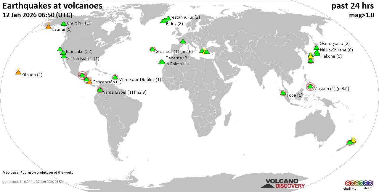 World map showing volcanoes with shallow (less than 50 km) earthquakes within 20 km radius during the past 24 hours on 12 Jan 2026 Number in brackets indicate nr of quakes. Quakes detected near: Abu (1 quake mag 1.0), Akagi (1 quake mag 1.6), Akuseki-jima (1 quake mag 2.9), Aso (9 quakes between mag 0.1-1.1), Bibinoi (1 quake mag 2.5), Chaîne des Puys (1 quake mag 1.9)
Churchill (1 quake mag 1.6), Clear Lake (31 quakes between mag 0.2-1.7), Colima (1 quake mag 3.0), Concepción (1 quake mag 1.8), Coso (2 quakes between mag 0.5-1.7), El Chichón (14 quakes between mag 1.9-2.8), Eldey (18 quakes between mag 0.5-1.9), Etna (1 quake mag 1.4), Fagradalsfjall (2 quakes between mag 0.1-1.8), Graciosa (1 quake mag 2.6), Hakkoda (1 quake mag 3.0), Hakone (1 quake mag 1.1), Hrómundartindur (5 quakes between mag 0.2-1.5), Katmai (1 quake mag 1.1), Kilauea (3 quakes between mag 1.7-1.9), La Palma (1 quake mag 1.3), Lipari (1 quake mag 2.4), Maunaloa (1 quake mag 1.7), Morne Plat Pays (1 quake mag 1.4), Morne aux Diables (1 quake mag 2.5), Musuan (1 quake mag 3.0), Nikko-Shirane (3 quakes between mag 0.6-1.2), Osore-yama (2 quakes between mag 0.7-1.5), Prestahnukur (2 quakes between mag 1.1-1.2), Ruapehu (1 quake mag 1.3), Salton Buttes (2 quakes between mag 1.4-1.6), Santa Isabel (1 quake mag 1.9), Santorini (2 quakes between mag 1.7-3.6), Sousaki (4 quakes between mag 1.6-2.0), Svartsengi (2 quakes between mag 0.6-1.0), Taranaki (1 quake mag 2.4), Tenerife (4 quakes between mag 0.8-1.2), Tjörnes Fracture Zone (2 quakes between mag 0.8-1.2), Toba (1 quake mag 2.3), Whale Island (1 quake mag 2.3) (updated 02h50)
Note: Earthquakes within 20 km from and at depths less than 50 km under active volcanoes are reported. The list is not complete because many volcanoes are not monitored and/or seismic data in high resolution is not available publicly.
Volcanoes with recent earthquakes above magnitude 2 or more than 10 quakes are listed below:
Akuseki-jima volcano (Ryukyu Islands): magnitude 2.9 earthquakeA magnitude 2.9 earthquake occurred at the volcano 9 hours ago. The quake, which might be volcanic in origin, was located at a depth of 0 km depth at 9 km distance SSE from the volcano. Earthquake details: 2.9 quake East China Sea, Kagoshima-ken, 30 km south of Suwanose-jima Island, Japan, Jan 12, 2026 02:41 am (GMT +9) (9 km SSE) All earthquakes at Akuseki-jimaBibinoi volcano (Halmahera): magnitude 2.5 earthquakeA magnitude 2.5 earthquake occurred at the volcano 21 hours ago. The quake, which might be volcanic in origin, was located at a depth of 2.00 km depth at 17 km distance NNW from the volcano. Earthquake details: 2.5 quake 22 km east of Labuha, Kabupaten Halmahera Selatan, North Maluku, Indonesia, Jan 11, 2026 02:32 pm (GMT +9) (17 km NNW) All earthquakes at BibinoiClear Lake volcano (California): 31 earthquakes up to magnitude 1.7Possible earthquake swarm: 31 earthquakes occurred near (under) the volcano during 23 hours, the last being recorded quake 1 hour 24 minutes ago. Hypocenter depths ranged between 3.41 and 0.57 km. Earthquake details: (only 5 largest) 1.7 quake Sonoma County, 13 mi southwest of Clearlake, Lake County, California, United States, Jan 11, 2026 04:40 pm (GMT -8) (17 km S) 1.6 quake 29 mi north of Santa Rosa, Sonoma County, California, United States, Jan 11, 2026 03:36 pm (GMT -8) (17 km SSW) 1.3 quake 27 mi north of Santa Rosa, Sonoma County, California, United States, Jan 11, 2026 12:30 pm (GMT -8) (17 km S) 1.3 quake 28 mi north of Santa Rosa, Sonoma County, California, United States, Jan 10, 2026 07:59 pm (GMT -8) (16 km SSW) 1.3 quake 28 mi north of Santa Rosa, Sonoma County, California, United States, Jan 11, 2026 05:05 pm (GMT -8) (16 km SSW) All earthquakes at Clear LakeColima volcano (Western & Central Mexico): magnitude 3.0 earthquakeA magnitude 3.0 earthquake occurred at the volcano 22 hours ago. The quake, which might be volcanic in origin, was located at a depth of 26.20 km depth at 17 km distance WNW from the volcano. Earthquake details: 3.0 quake 35 km southwest of Ciudad Guzman, Estado de Jalisco, Mexico, Jan 10, 2026 10:28 pm (GMT -6) (17 km WNW) All earthquakes at ColimaEl Chichón volcano (Southern Mexico): 14 earthquakes up to magnitude 2.8Possible earthquake swarm: 14 earthquakes occurred near (under) the volcano during 13 hours, the last being recorded quake 10 hours ago. Hypocenter depths ranged between 3.00 and 2.40 km. Earthquake details: (only 5 largest) 2.8 quake Estado de Chiapas, 36 km southwest of Teapa, Estado de Tabasco, Mexico, Jan 11, 2026 10:11 am (GMT -6) (1 km NNE) 2.7 quake Estado de Chiapas, 36 km southwest of Teapa, Estado de Tabasco, Mexico, Jan 11, 2026 04:45 am (GMT -6) (1 km N) 2.6 quake Estado de Chiapas, 38 km southwest of Teapa, Estado de Tabasco, Mexico, Jan 10, 2026 10:27 pm (GMT -6) (1 km SW) 2.5 quake Estado de Chiapas, 37 km southwest of Teapa, Estado de Tabasco, Mexico, Jan 11, 2026 09:07 am (GMT -6) (3 km NW) 2.5 quake Estado de Chiapas, 37 km southwest of Teapa, Estado de Tabasco, Mexico, Jan 11, 2026 10:34 am (GMT -6) (0 km NW) All earthquakes at El ChichónEldey volcano (Iceland): 18 earthquakes up to magnitude 1.9Possible earthquake swarm: 18 earthquakes occurred near (under) the volcano during 10 hours, the last being recorded quake 12 hours ago. Hypocenter depths ranged between 17.50 and 1.10 km. Earthquake details: (only 5 largest) 1.9 quake Iceland: 13.7 km S of Eldeyjardrangur Jan 11, 2026 06:08 am (Reykjavik time) (14 km S) 1.7 quake Iceland: 12.8 km SSE of Geirfuglasker Jan 11, 2026 06:19 am (Reykjavik time) (16 km SSW) 1.6 quake Iceland: 13.6 km SSE of Geirfuglasker Jan 11, 2026 06:05 am (Reykjavik time) (18 km SSW) 1.4 quake Iceland: 15.9 km SSE of Geirfuglasker Jan 11, 2026 06:12 am (Reykjavik time) (18 km S) 1.4 quake Iceland: 5.2 km SSE of Geirfuglasker Jan 11, 2026 06:57 am (Reykjavik time) (13 km SW) All earthquakes at EldeyEldey is located at the beginning of the Reykjanes Ridge off the SW tip of Iceland. Its highest elevation is the top of Eldey Island, but most of the volcanic edifice is submerged. Several eruptions occurred in historic times, last in 1926. Graciosa volcano (Azores): magnitude 2.6 earthquakeA magnitude 2.6 earthquake occurred at the volcano 4 hours ago. The quake, which might be volcanic in origin, was located at a depth of 4.50 km depth at 9 km distance WNW from the volcano. Earthquake details: 2.6 quake 6 km southwest of Santa Cruz da Graciosa, Azores, Portugal, Jan 11, 2026 09:29 pm (GMT -1) (9 km WNW) All earthquakes at GraciosaHakkoda volcano (Honshu): magnitude 3.0 earthquakeA magnitude 3.0 earthquake occurred at the volcano 21 hours ago. The quake, which might be volcanic in origin, was located at a depth of 10.00 km depth at 10 km distance SSE from the volcano. Earthquake details: Reported seismic-like event (likely no quake): 32 km southeast of Aomori, Aomori, Japan, Jan 11, 2026 02:34 pm (GMT +9) (10 km SSE) All earthquakes at HakkodaLipari volcano (Eolian Islands): magnitude 2.4 earthquakeA magnitude 2.4 earthquake occurred at the volcano 22 hours ago. The quake, which might be volcanic in origin, was located at a depth of 10.30 km depth at 12 km distance W from the volcano. Earthquake details: 2.4 quake Tyrrhenian Sea, 9.4 km southwest of Isola Salina Island, Sicily, Italy, Jan 11, 2026 05:44 am (GMT +1) (12 km W) All earthquakes at LipariMorne aux Diables volcano (Caribbean): magnitude 2.5 earthquakeA magnitude 2.5 earthquake occurred at the volcano 18 hours ago. The quake, which might be volcanic in origin, was located at a depth of 11.60 km depth at 18 km distance NW from the volcano. Earthquake details: 2.5 quake Caribbean Sea, 39 km northwest of Dominica Island, Dominica, Jan 11, 2026 04:43 am (GMT -4) (18 km NW) All earthquakes at Morne aux DiablesMusuan volcano (Mindanao): magnitude 3.0 earthquakeA magnitude 3.0 earthquake occurred at the volcano 13 hours ago. The quake, which might be volcanic in origin, was located at a depth of 10.00 km depth at 6 km distance WSW from the volcano. Earthquake details: Reported seismic-like event (likely no quake): 16 km northwest of Quezon, Province of Bukidnon, Northern Mindanao, Philippines, Jan 11, 2026 09:51 pm (GMT +8) (6 km WSW) All earthquakes at MusuanSantorini volcano (Greece): 2 earthquakes up to magnitude 3.62 earthquakes occurred near (under) the volcano during 9 hours, the last being recorded quake 11 hours ago. Hypocenter depths ranged between 12.40 and 10.62 km. Earthquake details: 3.6 quake Aegean Sea, 4.4 km east of Santorini Island, Greece, Jan 11, 2026 09:09 am (GMT +2) (10 km E) 1.7 quake 3.7 km southeast of Fira, Nomos Kykladon, South Aegean, Greece, Jan 11, 2026 06:00 pm (GMT +2) (6 km E) All earthquakes at SantoriniTaranaki volcano (North Island): magnitude 2.4 earthquakeA magnitude 2.4 earthquake occurred at the volcano 19 hours ago. The quake, which might be volcanic in origin, was located at a depth of 9.60 km depth at 9 km distance SE from the volcano. Earthquake details: 2.4 quake 32 km south of New Plymouth, Taranaki, New Zealand, Jan 11, 2026 08:43 pm (GMT +13) (9 km SE) All earthquakes at TaranakiToba volcano (Sumatra): magnitude 2.3 earthquakeA magnitude 2.3 earthquake occurred at the volcano 8 hours ago. The quake, which might be volcanic in origin, was located at a depth of 21.00 km depth at 14 km distance NW from the volcano. Earthquake details: 2.3 quake 14 km west of Nainggolan, Kabupaten Samosir, North Sumatra, Indonesia, Jan 12, 2026 01:28 am (GMT +7) (14 km NW) All earthquakes at TobaWhale Island volcano (New Zealand): magnitude 2.3 earthquakeA magnitude 2.3 earthquake occurred at the volcano 44 minutes ago. The quake, which might be volcanic in origin, was located at a depth of 31.70 km depth at 9 km distance SSE from the volcano. Earthquake details: 2.3 quake South Pacific Ocean, 4.6 km northeast of Whakatane, Bay of Plenty, New Zealand, Jan 12, 2026 03:06 pm (GMT +13) (9 km SSE) All earthquakes at Whale Islandhttps://www.volcanodiscovery.com/earthquakes-volcanoes/news/291728/Volcano-earthquake-report-for-Monday-12-Jan-2026.html
0
18
Read More
|
World Earthquake Report for Sunday, 11 January 2026
Webmaster
7 hours ago
World Earthquake Report for Sunday, 11 January 2026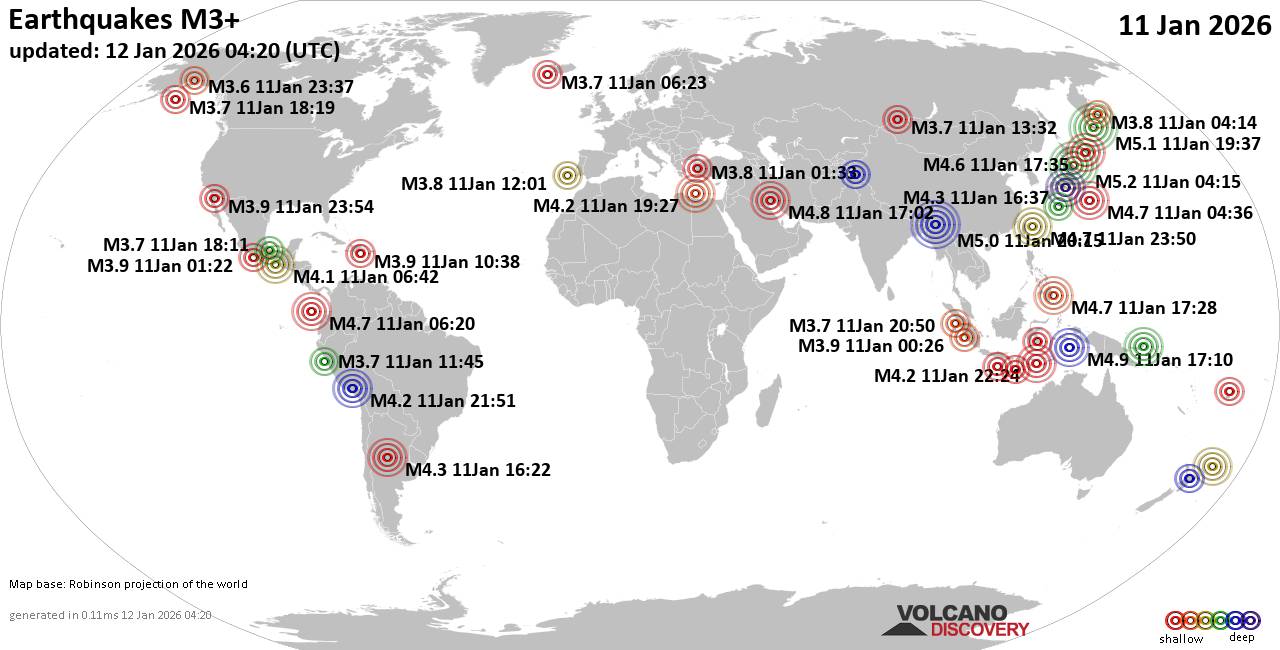 Worldwide earthquakes above magnitude 3 during the past 24 hours on 12 Jan 2026 Magnitude 5+: 3 earthquakes Magnitude 4+: 40 earthquakes Magnitude 3+: 184 earthquakes Magnitude 2+: 455 earthquakes No quakes of magnitude 6 or higher 10 largest earthquakes in the world (11 Jan 2026)Sunday, Jan 11, 2026, at 01:15 pm (GMT +9) - Monday, Jan 12, 2026, at 06:37 am (GMT +11) - Monday, Jan 12, 2026, at 01:45 am (Kolkata time) - Monday, Jan 12, 2026, at 02:10 am (GMT +9) - Sunday, Jan 11, 2026, at 06:29 pm (GMT +11) - Sunday, Jan 11, 2026, at 08:32 pm (Tehran time) - Monday, Jan 12, 2026, at 05:27 am (GMT +11) - Sunday, Jan 11, 2026, at 01:20 am (GMT -5) - Monday, Jan 12, 2026, at 01:28 am (Manila time) - Sunday, Jan 11, 2026, at 01:36 pm (GMT +9) - Earthquakes reported feltMonday, Jan 12, 2026, at 01:45 am (Kolkata time) - Sunday, Jan 11, 2026, at 01:01 pm (GMT +13) - Sunday, Jan 11, 2026, at 08:32 pm (Tehran time) - Sunday, Jan 11, 2026, at 01:22 pm (San Luis time) - Saturday, Jan 10, 2026, at 08:10 pm (GMT -8) - Sunday, Jan 11, 2026, at 01:15 pm (GMT +9) - Sunday, Jan 11, 2026, at 09:09 am (GMT +2) - Saturday, Jan 10, 2026, at 08:21 pm (GMT -8) - Sunday, Jan 11, 2026, at 04:17 am (GMT +3) - Monday, Jan 12, 2026, at 01:28 am (Manila time) - Sunday, Jan 11, 2026, at 01:51 pm (GMT +9) - Sunday, Jan 11, 2026, at 04:33 am (GMT +3) - Sunday, Jan 11, 2026, at 09:32 pm (GMT +2) - Sunday, Jan 11, 2026, at 09:27 pm (GMT +2) - Sunday, Jan 11, 2026, at 02:57 pm (GMT -4) - Saturday, Jan 10, 2026, at 10:43 pm (GMT -8) - Sunday, Jan 11, 2026, at 10:04 pm (GMT +1) - Sunday, Jan 11, 2026, at 05:54 am (GMT +3) - Saturday, Jan 10, 2026, at 10:01 pm (GMT -8) - Sunday, Jan 11, 2026, at 01:18 pm (GMT +9) - Sunday, Jan 11, 2026, at 07:42 pm (GMT +1) - Earthquake stats  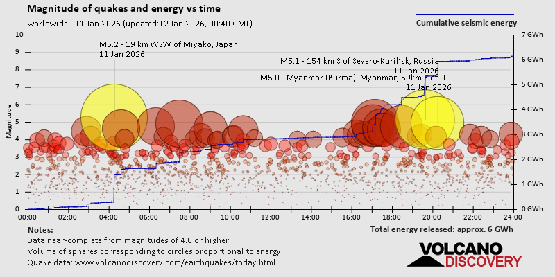 https://www.volcanodiscovery.com/earthquake/news/291674/World-Earthquake-Report-for-Sunday-11-January-2026.html https://www.volcanodiscovery.com/earthquake/news/291674/World-Earthquake-Report-for-Sunday-11-January-2026.html
0
20
Read More
|
Tuesday: Heavy Rain, Minimum Temperature: 3°C (37°F) Maximum Temperature: 9°C (49°F)
Webmaster
7 hours ago
Maximum Temperature: 9°C (49°F), Minimum Temperature: 3°C (37°F), Wind Direction: Southerly, Wind Speed: 6mph, Visibility: Moderate, Pressure: 1000mb, Humidity: 90%, UV Risk: 1, Pollution: Low, Sunrise: 08:18 GMT, Sunset: 16:18 GMT Source: Tuesday: Heavy Rain, Minimum Temperature: 3°C (37°F) Maximum Temperature: 9°C (49°F)
0
13
Read More
|
Monday: Light Rain Showers, Minimum Temperature: 7°C (44°F) Maximum Temperature: 11°C (51°F)
Webmaster
7 hours ago
Maximum Temperature: 11°C (51°F), Minimum Temperature: 7°C (44°F), Wind Direction: Southerly, Wind Speed: 9mph, Visibility: Moderate, Pressure: 997mb, Humidity: 86%, UV Risk: 1, Pollution: Low, Sunrise: 08:19 GMT, Sunset: 16:17 GMT Source: Monday: Light Rain Showers, Minimum Temperature: 7°C (44°F) Maximum Temperature: 11°C (51°F)
0
14
Read More
|
Volcano earthquake report for Sunday, 11 Jan 2026
Webmaster
Yesterday at 11:50 PM
Volcano earthquake report for Sunday, 11 Jan 2026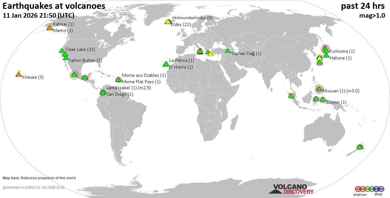 World map showing volcanoes with shallow (less than 50 km) earthquakes within 20 km radius during the past 24 hours on 11 Jan 2026 Number in brackets indicate nr of quakes. Quakes detected near: Abu (2 quakes between mag 0.6-1.0), Akuseki-jima (1 quake mag 2.9), Aso (11 quakes between mag 0.1-1.2), Bibinoi (1 quake mag 2.5), Chaîne des Puys (1 quake mag 1.9), Clear Lake (33 quakes between mag 0.2-1.6)
Colima (1 quake mag 3.0), Coso (3 quakes between mag 0.5-1.7), El Chichón (9 quakes between mag 1.9-2.7), El Hierro (1 quake mag 1.2), Eldey (21 quakes between mag 0.5-1.9), Etna (1 quake mag 1.4), Fagradalsfjall (2 quakes between mag 0.1-1.8), Graciosa (1 quake mag 2.6), Hakkoda (1 quake mag 3.0), Hakone (1 quake mag 1.1), Hrómundartindur (8 quakes between mag 0.2-1.5), Katmai (1 quake mag 1.1), Kilauea (3 quakes between mag 1.7-1.9), Kurikoma (1 quake mag 1.8), La Palma (1 quake mag 1.3), Lipari (1 quake mag 2.4), Maunaloa (1 quake mag 1.7), Morne Plat Pays (1 quake mag 1.4), Morne aux Diables (1 quake mag 2.5), Musuan (1 quake mag 3.0), Nikko-Shirane (3 quakes between mag 0.6-1.2), Osore-yama (2 quakes between mag 0.7-1.5), Ruapehu (1 quake mag 1.3), Salton Buttes (2 quakes between mag 1.4-1.6), San Diego (1 quake mag 1.4), Santa Isabel (1 quake mag 2.9), Santorini (2 quakes between mag 1.7-3.6), Sousaki (3 quakes between mag 1.6-2.0), Svartsengi (2 quakes between mag 0.6-1.0), Taranaki (1 quake mag 2.4), Tenerife (4 quakes between mag 0.8-1.2), Tjörnes Fracture Zone (2 quakes between mag 0.8-1.2), Toba (1 quake mag 2.3), Una Una (1 quake mag 2.0) (updated 23h50)
Note: Earthquakes within 20 km from and at depths less than 50 km under active volcanoes are reported. The list is not complete because many volcanoes are not monitored and/or seismic data in high resolution is not available publicly.
Volcanoes with recent earthquakes above magnitude 2 or more than 10 quakes are listed below:
Akuseki-jima volcano (Ryukyu Islands): magnitude 2.9 earthquakeA magnitude 2.9 earthquake occurred at the volcano 6 hours ago. The quake, which might be volcanic in origin, was located at a depth of 0 km depth at 9 km distance SSE from the volcano. Earthquake details: 2.9 quake East China Sea, Kagoshima-ken, 30 km south of Suwanose-jima Island, Japan, Jan 12, 2026 02:41 am (GMT +9) (9 km SSE) All earthquakes at Akuseki-jimaAso volcano (Kyushu): 11 earthquakes up to magnitude 1.2Possible earthquake swarm: 11 earthquakes occurred near (under) the volcano during 21 hours, the last being recorded quake 2 hours ago. Hypocenter depths ranged between 11.40 and 7.00 km. Earthquake details: (only 5 largest) 1.2 quake 9.2 km northeast of Aso, Kumamoto, Japan, Jan 11, 2026 09:25 am (GMT +9) (14 km N) 1.1 quake 6.2 km northeast of Aso, Kumamoto, Japan, Jan 11, 2026 01:50 pm (GMT +9) (12 km N) 1.1 quake 7.4 km northeast of Aso, Kumamoto, Japan, Jan 11, 2026 12:03 pm (GMT +9) (12 km N) 0.8 quake 3.2 km northwest of Aso, Kumamoto, Japan, Jan 11, 2026 02:55 pm (GMT +9) (9 km NW) 0.8 quake 48 km northeast of Kumamoto, Kumamoto, Japan, Jan 11, 2026 02:54 pm (GMT +9) (12 km NNE) All earthquakes at AsoBibinoi volcano (Halmahera): magnitude 2.5 earthquakeA magnitude 2.5 earthquake occurred at the volcano 18 hours ago. The quake, which might be volcanic in origin, was located at a depth of 2.00 km depth at 17 km distance NNW from the volcano. Earthquake details: 2.5 quake 22 km east of Labuha, Kabupaten Halmahera Selatan, North Maluku, Indonesia, Jan 11, 2026 02:32 pm (GMT +9) (17 km NNW) All earthquakes at BibinoiClear Lake volcano (California): 33 earthquakes up to magnitude 1.6Possible earthquake swarm: 33 earthquakes occurred near (under) the volcano during 23 hours, the last being recorded quake 13 minutes ago. Hypocenter depths ranged between 3.41 and 0.57 km. Earthquake details: (only 5 largest) 1.6 quake 29 mi north of Santa Rosa, Sonoma County, California, United States, Jan 11, 2026 03:36 pm (GMT -8) (17 km SSW) 1.6 quake 27 mi north of Santa Rosa, Sonoma County, California, United States, Jan 10, 2026 04:13 pm (GMT -8) (18 km SSW) 1.3 quake 28 mi north of Santa Rosa, Sonoma County, California, United States, Jan 10, 2026 07:59 pm (GMT -8) (16 km SSW) 1.3 quake 27 mi north of Santa Rosa, Sonoma County, California, United States, Jan 11, 2026 12:30 pm (GMT -8) (17 km S) 1.2 quake 27 mi north of Santa Rosa, Sonoma County, California, United States, Jan 10, 2026 06:53 pm (GMT -8) (17 km S) All earthquakes at Clear LakeColima volcano (Western & Central Mexico): magnitude 3.0 earthquakeA magnitude 3.0 earthquake occurred at the volcano 19 hours ago. The quake, which might be volcanic in origin, was located at a depth of 26.20 km depth at 17 km distance WNW from the volcano. Earthquake details: 3.0 quake 35 km southwest of Ciudad Guzman, Estado de Jalisco, Mexico, Jan 10, 2026 10:28 pm (GMT -6) (17 km WNW) All earthquakes at ColimaEl Chichón volcano (Southern Mexico): 9 earthquakes up to magnitude 2.79 earthquakes occurred near (under) the volcano during 7 hours, the last being recorded quake 13 hours ago. Hypocenter depths ranged between 3.00 and 3.00 km. Earthquake details: (only 5 largest) 2.7 quake Estado de Chiapas, 36 km southwest of Teapa, Estado de Tabasco, Mexico, Jan 11, 2026 04:45 am (GMT -6) (1 km N) 2.6 quake Estado de Chiapas, 38 km southwest of Teapa, Estado de Tabasco, Mexico, Jan 10, 2026 10:27 pm (GMT -6) (1 km SW) 2.5 quake Estado de Chiapas, 36 km southwest of Teapa, Estado de Tabasco, Mexico, Jan 10, 2026 11:07 pm (GMT -6) (1 km E) 2.4 quake Estado de Chiapas, 36 km southwest of Teapa, Estado de Tabasco, Mexico, Jan 10, 2026 11:32 pm (GMT -6) (1 km N) 2.4 quake Estado de Chiapas, 36 km southwest of Teapa, Estado de Tabasco, Mexico, Jan 11, 2026 03:29 am (GMT -6) (1 km NNE) All earthquakes at El ChichónEldey volcano (Iceland): 21 earthquakes up to magnitude 1.9Possible earthquake swarm: 21 earthquakes occurred near (under) the volcano during 14 hours, the last being recorded quake 9 hours ago. Hypocenter depths ranged between 17.50 and 1.10 km. Earthquake details: (only 5 largest) 1.9 quake Iceland: 13.7 km S of Eldeyjardrangur Jan 11, 2026 06:08 am (Reykjavik time) (14 km S) 1.7 quake Iceland: 12.8 km SSE of Geirfuglasker Jan 11, 2026 06:19 am (Reykjavik time) (16 km SSW) 1.6 quake Iceland: 13.6 km SSE of Geirfuglasker Jan 11, 2026 06:05 am (Reykjavik time) (18 km SSW) 1.5 quake 7.8 km W of Reykjanestá Jan 11, 2026 01:33 am (Universal Time) (10 km NE) 1.4 quake Iceland: 5.2 km SSE of Geirfuglasker Jan 11, 2026 06:57 am (Reykjavik time) (13 km SW) All earthquakes at EldeyEldey is located at the beginning of the Reykjanes Ridge off the SW tip of Iceland. Its highest elevation is the top of Eldey Island, but most of the volcanic edifice is submerged. Several eruptions occurred in historic times, last in 1926. Graciosa volcano (Azores): magnitude 2.6 earthquakeA magnitude 2.6 earthquake occurred at the volcano 1 hour 21 minutes ago. The quake, which might be volcanic in origin, was located at a depth of 4.50 km depth at 9 km distance WNW from the volcano. Earthquake details: 2.6 quake 6 km southwest of Santa Cruz da Graciosa, Azores, Portugal, Jan 11, 2026 09:29 pm (GMT -1) (9 km WNW) All earthquakes at GraciosaHakkoda volcano (Honshu): magnitude 3.0 earthquakeA magnitude 3.0 earthquake occurred at the volcano 18 hours ago. The quake, which might be volcanic in origin, was located at a depth of 10.00 km depth at 10 km distance SSE from the volcano. Earthquake details: Reported seismic-like event (likely no quake): 32 km southeast of Aomori, Aomori, Japan, Jan 11, 2026 02:34 pm (GMT +9) (10 km SSE) All earthquakes at HakkodaLipari volcano (Eolian Islands): magnitude 2.4 earthquakeA magnitude 2.4 earthquake occurred at the volcano 19 hours ago. The quake, which might be volcanic in origin, was located at a depth of 10.30 km depth at 12 km distance W from the volcano. Earthquake details: 2.4 quake Tyrrhenian Sea, 9.4 km southwest of Isola Salina Island, Sicily, Italy, Jan 11, 2026 05:44 am (GMT +1) (12 km W) All earthquakes at LipariMorne aux Diables volcano (Caribbean): magnitude 2.5 earthquakeA magnitude 2.5 earthquake occurred at the volcano 15 hours ago. The quake, which might be volcanic in origin, was located at a depth of 11.60 km depth at 18 km distance NW from the volcano. Earthquake details: 2.5 quake Caribbean Sea, 39 km northwest of Dominica Island, Dominica, Jan 11, 2026 04:43 am (GMT -4) (18 km NW) All earthquakes at Morne aux DiablesMusuan volcano (Mindanao): magnitude 3.0 earthquakeA magnitude 3.0 earthquake occurred at the volcano 10 hours ago. The quake, which might be volcanic in origin, was located at a depth of 10.00 km depth at 6 km distance WSW from the volcano. Earthquake details: Reported seismic-like event (likely no quake): 16 km northwest of Quezon, Province of Bukidnon, Northern Mindanao, Philippines, Jan 11, 2026 09:51 pm (GMT +8) (6 km WSW) All earthquakes at MusuanSanta Isabel volcano (Colombia): magnitude 2.9 earthquakeA magnitude 2.9 earthquake occurred at the volcano 8 hours ago. The quake, which might be volcanic in origin, was located at a depth of 5.00 km depth at 3 km distance WSW from the volcano. Earthquake details: 2.9 quake 32 km southeast of Manizales, Departamento de Caldas, Colombia, Jan 11, 2026 10:59 am (GMT -5) (3 km WSW) All earthquakes at Santa IsabelSantorini volcano (Greece): 2 earthquakes up to magnitude 3.62 earthquakes occurred near (under) the volcano during 9 hours, the last being recorded quake 8 hours ago. Hypocenter depths ranged between 12.40 and 10.62 km. Earthquake details: 3.6 quake Aegean Sea, 4.4 km east of Santorini Island, Greece, Jan 11, 2026 09:09 am (GMT +2) (10 km E) 1.7 quake 3.7 km southeast of Fira, Nomos Kykladon, South Aegean, Greece, Jan 11, 2026 06:00 pm (GMT +2) (6 km E) All earthquakes at SantoriniTaranaki volcano (North Island): magnitude 2.4 earthquakeA magnitude 2.4 earthquake occurred at the volcano 16 hours ago. The quake, which might be volcanic in origin, was located at a depth of 9.60 km depth at 9 km distance SE from the volcano. Earthquake details: 2.4 quake 32 km south of New Plymouth, Taranaki, New Zealand, Jan 11, 2026 08:43 pm (GMT +13) (9 km SE) All earthquakes at TaranakiToba volcano (Sumatra): magnitude 2.3 earthquakeA magnitude 2.3 earthquake occurred at the volcano 5 hours ago. The quake, which might be volcanic in origin, was located at a depth of 21.00 km depth at 14 km distance NW from the volcano. Earthquake details: 2.3 quake 14 km west of Nainggolan, Kabupaten Samosir, North Sumatra, Indonesia, Jan 12, 2026 01:28 am (GMT +7) (14 km NW) All earthquakes at Tobahttps://www.volcanodiscovery.com/earthquakes-volcanoes/news/291665/Volcano-earthquake-report-for-Sunday-11-Jan-2026.html
0
5
Read More
|
Small 3.6 quake hits near Anchorage, Alaska, USA
Webmaster
Yesterday at 11:46 PM
Small 3.6 quake hits near Anchorage, Alaska, USA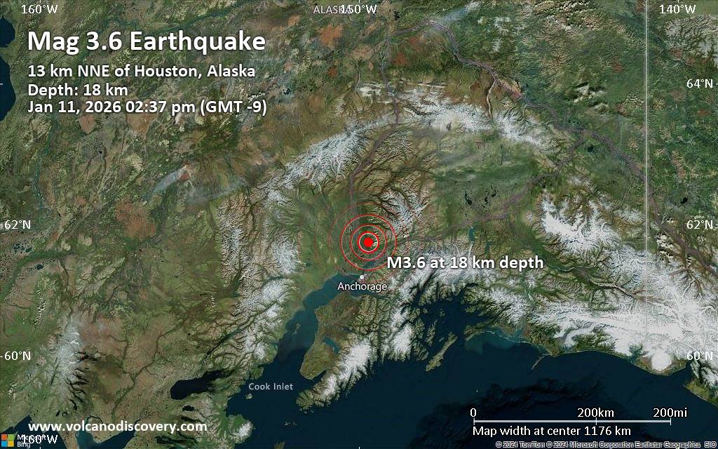 An earthquake of magnitude 3.6 occurred only 8 minutes ago 37 miles north of Anchorage, Alaska, United States, the United States Geological Survey reported.
The quake hit at a shallow depth of 11 miles beneath the epicenter near Anchorage, Alaska, USA, early afternoon on Sunday, January 11th, 2026, at 2:37 pm local time. The exact magnitude, epicenter, and depth of the quake might be revised within the next few hours or minutes as seismologists review data and refine their calculations, or as other agencies issue their report.
A second report was later issued by The Incorporated Research Institutions for Seismology (IRIS), which listed it as a magnitude 3.6 earthquake as well. A third agency, the European-Mediterranean Seismological Centre (EMSC), reported the same quake at magnitude 3.6.
Towns or cities near the epicenter where the quake might have been felt as very weak shaking include Houston (pop. 2,200) located 9 miles from the epicenter, Meadow Lakes (pop. 7,600) 9 miles away, Tanaina (pop. 8,200) 12 miles away, Wasilla (pop. 9,300) 14 miles away, Fishhook (pop. 4,700) 15 miles away, Lakes (pop. 8,400) 16 miles away, Knik-Fairview (pop. 14,900) 16 miles away, Eagle River (pop. 24,800) 29 miles away, Eagle River (pop. 24,800) 29 miles away, and Anchorage (pop. 289,600) 37 miles away.
Earthquake data: Date & time: Jan 11, 2026 11:37 pm (Universal Time) local time (11 Jan 2026 23:37 GMT)Magnitude: 3.6 Depth: 18.40 km Epicenter latitude / longitude: 61.74°N / 149.7°W  ( Matanuska-Susitna Borough, Alaska, United States) Primary data source: USGShttps://www.volcanodiscovery.com/earthquake/news/291726/Small-36-quake-hits-near-Anchorage-Alaska-USA.html
0
4
Read More
|
Magnitude 4.5 earthquake strikes near Tatkon, Hkamti District, Sagaing Region, Myanmar (Burma)
Webmaster
Yesterday at 08:34 PM
Magnitude 4.5 earthquake strikes near Tatkon, Hkamti District, Sagaing Region, Myanmar (Burma)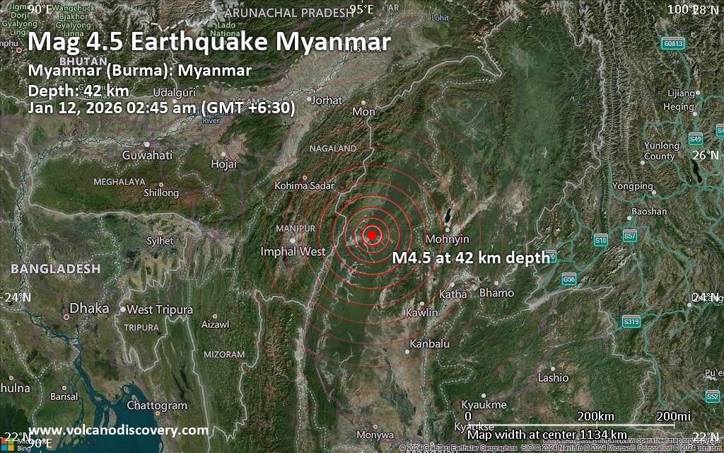 Just 17 minutes ago, a 4.5-magnitude earthquake struck near Tatkon, Hkamti District, Sagaing Region, Myanmar (Burma). The tremor was recorded early morning on Monday, January 12th, 2026, at 2:15 am local time, at a moderately shallow depth of 42. km below the surface.
The event was filed by Thailand's Earthquake Observation Division (TMD), the first seismological agency to report it.
Based on the preliminary seismic data, the quake should not have caused any significant damage, but was probably felt by many people as light vibration in the area of the epicenter.
Weak shaking might have been felt in Tatkon (pop. 41,700) located 23 km from the epicenter, and Homalin (pop. 1,500) 26 km away.
Other towns or cities near the epicenter where the quake might have been felt as very weak shaking include Minsin (pop. 1,800) located 76 km from the epicenter, Ukhrul (pop. 27,200) 85 km away, and Kyauktan (pop. 42,800) 99 km away.
VolcanoDiscovery will automatically update magnitude and depth if these change and follow up if other significant news about the quake become available. If you’re in the area, please send us your experience through our reporting mechanism, either online or via our mobile app. This will help us provide more first-hand updates to anyone around the globe who wants to know more about this quake.
Earthquake data: Date & time: Jan 12, 2026 02:45 am (Yangon time) local time (11 Jan 2026 20:15 GMT)Magnitude: 4.5 Depth: 42.00 km Epicenter latitude / longitude: 24.87°N / 95.16°E  (Hkamti, Sagaing Region, Myanmar (Burma)) Primary data source: TMDhttps://www.volcanodiscovery.com/earthquake/news/291719/Magnitude-45-earthquake-strikes-near-Tatkon-Hkamti-District-Sagaing-Region-Myanmar-Burma.html
0
5
Read More
|
Seismic-like event, possible earthquake, reported few minutes ago near Shillong, Meghalaya, India
Webmaster
Yesterday at 08:22 PM
Seismic-like event, possible earthquake, reported few minutes ago near Shillong, Meghalaya, India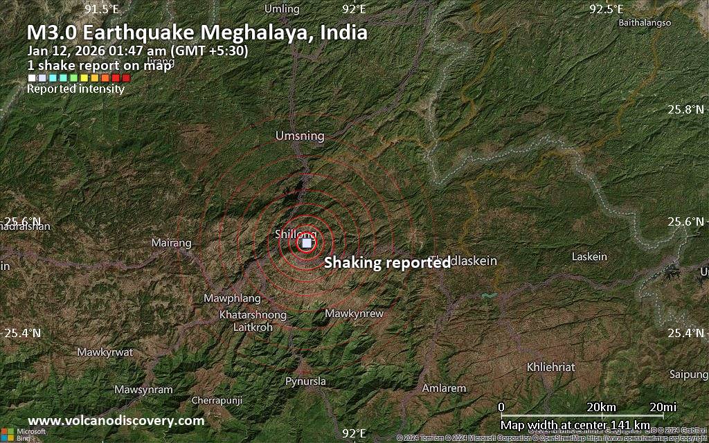 Unconfirmed quake or seismic-like event reported: 30 km west of Dimapur, Dimapur, State of Nagaland, India, 5 minutes ago We are receiving unverified early reports of ground shaking possibly caused by seismic activity in or near Shillong, Meghalaya, India on 11 Jan 2026 (GMT) at approximately 20:17 GMT.
There are no details yet on the magnitude or depth of this possible quake. If confirmed, we can expect more accurate data to emerge in the next few minutes. The location, magnitude and time mentioned are indicative, based on our best-fit seismic model. They are temporary until our AllQuakes monitoring service receives more exact scientific data from a national or international seismological agency. Check back here shortly and stay safe.
Earthquake data: Date & time: Jan 12, 2026 01:47 am (GMT +5:30) local time (11 Jan 2026 20:17 GMT)Magnitude: unspecified Depth: unspecified Epicenter latitude / longitude: 25.56°N / 91.9°E  ( Meghalaya, India) Primary data source: VolcanoDiscoveryhttps://www.volcanodiscovery.com/earthquake/news/291717/Seismic-like-event-possible-earthquake-reported-few-minutes-ago-near-Shillong-Meghalaya-India.html
0
4
Read More
|
Magnitude 2.8 earthquake strikes near Glogow, Głogów County, Lower Silesian Voivodeship, Poland
Webmaster
Yesterday at 08:07 PM
Magnitude 2.8 earthquake strikes near Glogow, Głogów County, Lower Silesian Voivodeship, Poland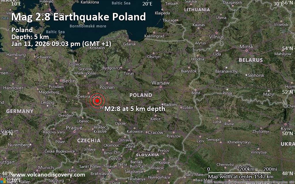 An earthquake of magnitude 2.8 occurred in the evening on Sunday, January 11th, 2026, at 9:03 pm local time near Glogow, Głogów County, Lower Silesian Voivodeship, Poland, as reported by the European-Mediterranean Seismological Centre (EMSC).
According to preliminary data, the quake was located at a very shallow depth of 5. km. Shallow earthquakes are felt more strongly than deeper ones as they are closer to the surface. The exact magnitude, epicenter, and depth of the quake might be revised within the next few hours or minutes as seismologists review data and refine their calculations, or as other agencies issue their report.
Based on the preliminary seismic data, the quake should not have caused any significant damage, but was probably felt by many people as light vibration in the area of the epicenter.
Weak shaking might have been felt in Grebocice (pop. 1,500) located 1 km from the epicenter.
Other towns or cities near the epicenter where the quake might have been felt as very weak shaking include Glogow (pop. 65,400) located 10 km from the epicenter, and Polkowice (pop. 21,600) 12 km away. In Lubin (pop. 77,500, 21 km away), Nowa Sol (pop. 40,400, 39 km away), Leszno (pop. 63,600, 39 km away), Legnica (pop. 106,000, 42 km away), and Rawicz (pop. 21,400, 48 km away), the quake was probably not felt.
Earthquake data: Date & time: Jan 11, 2026 09:03 pm (GMT +1) local time (11 Jan 2026 20:03 GMT)Magnitude: 2.8 Depth: 5.00 km Epicenter latitude / longitude: 51.59°N / 16.17°E  (Powiat polkowicki, Lower Silesian Voivodeship, Poland) Primary data source: EMSChttps://www.volcanodiscovery.com/earthquake/news/291715/Magnitude-28-earthquake-strikes-near-Glogow-Gogow-County-Lower-Silesian-Voivodeship-Poland.html
0
5
Read More
|
World Earthquake Report for January 2026
Webmaster
Yesterday at 07:00 PM
World Earthquake Report for January 2026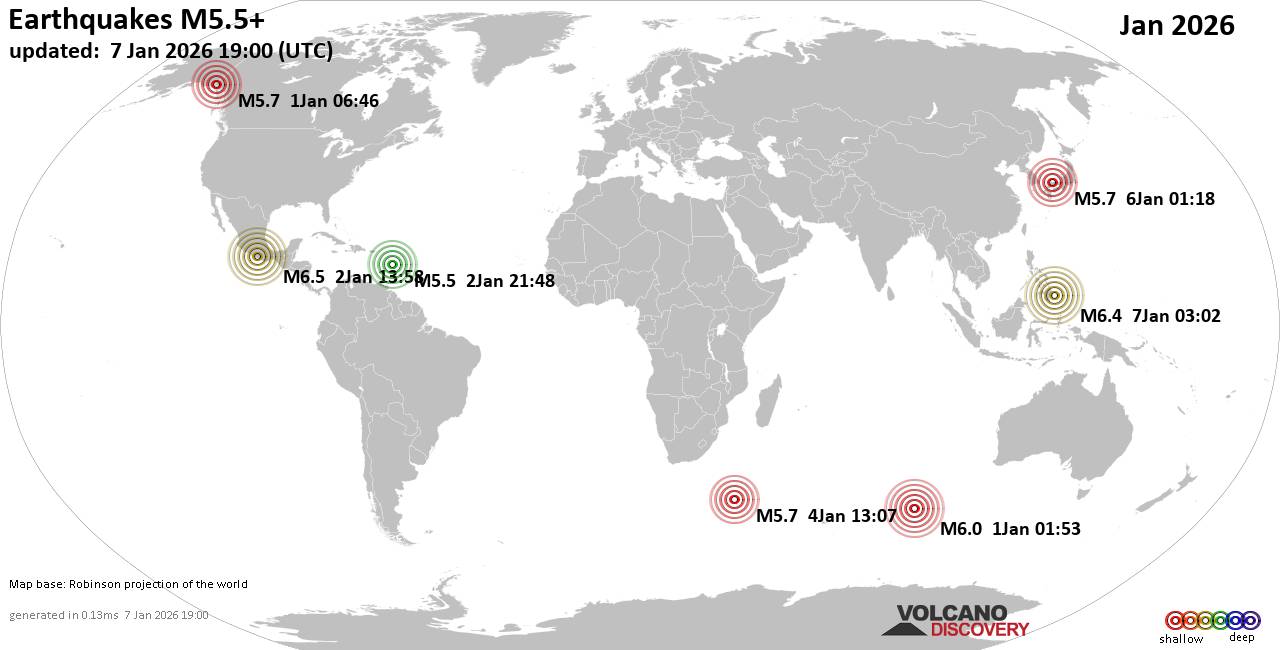 Worldwide earthquakes above magnitude 5.5 during January 2026 Magnitude 9+: none Magnitude 8+: none Magnitude 7+: none Magnitude 6+: 4 earthquakes Magnitude 5+: 55 earthquakes Magnitude 4+: 440 earthquakes Magnitude 3+: 2191 earthquakes Magnitude 2+: 4924 earthquakes No quakes of magnitude 7 or higher List of 10 largest earthquakes in the world during January 2026:Friday, Jan 2, 2026, at 07:58 am (Mexico City time) - Thursday, Jan 1, 2026, at 07:53 am (GMT +6) - Saturday, Jan 3, 2026, at 04:07 pm (GMT +6) - Wednesday, Dec 31, 2025, at 11:46 pm (Whitehorse time) - Friday, Jan 2, 2026, at 05:48 pm (GMT -4) - Earthquake stats: 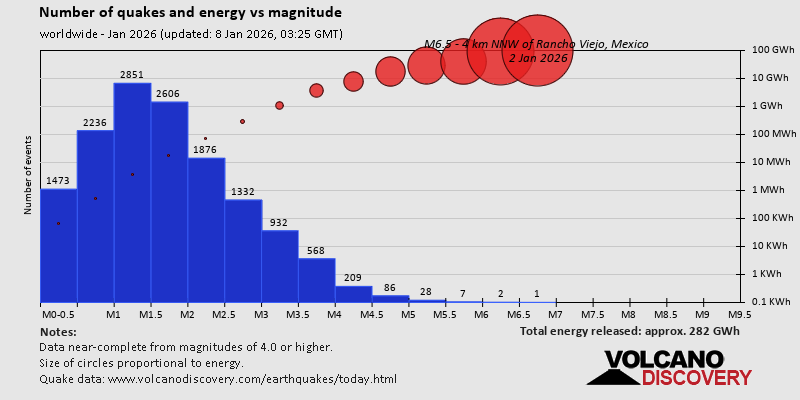 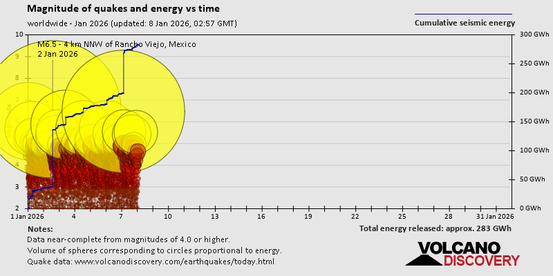 https://www.volcanodiscovery.com/view_news/290900/World-Earthquake-Report-for-January-2026.html https://www.volcanodiscovery.com/view_news/290900/World-Earthquake-Report-for-January-2026.html
0
5
Read More
|
|
Forums60
Topics755,691
Posts790,390
Members2,958
| |
Most Online12,408
Dec 19th, 2025
|
|
|
|
|
Copyright 1996 - 2026 by David Cottle. Designed by David Bate Jr. All Rights Reserved.
By using this forum, the user agrees not to transfer any data or technical information received under the agreement, to any other entity without the express approval of the AUS-CITY Forum Admins and/or authors of individual posts (Forum Admins and DoD/USSPACECOM for the analysis of satellite tracking data).
Two-line elements (TLE) and all other satellite data presented and distributed via this forum and e-mail lists of AUS-CITY are distributed with permission from DoD/USSTRATCOM.


Reprise Hosting

|

|


 - Click image for larger picture.")


