|
|
|
1 members (Alisa),
817
guests, and
19
robots. |
|
Key:
Admin,
Global Mod,
Mod
|
|
S |
M |
T |
W |
T |
F |
S |
|
|
|
|
1
|
2
|
3
|
4
|
|
5
|
6
|
7
|
8
|
9
|
10
|
11
|
|
12
|
13
|
14
|
15
|
16
|
17
|
18
|
|
19
|
20
|
21
|
22
|
23
|
24
|
25
|
|
26
|
27
|
28
|
29
|
30
|
31
|
|
|
There are no members with birthdays on this day. |

Volcano earthquake report for Friday, 31 Jul 2026
• World Earthquake Report for Friday, 31 July 2026
• Light mag. 3.9 earthquake - Philippine Sea, 57 km east of Sulangan, Philipp...
• Small tremor of magnitude 3.1 just reported 10 km southwest of Naples, Ital...
• Seismic-like event, possible earthquake, reported few minutes ago near Napl...
• Strong mag. 5.0 earthquake - 65 km northeast of Pu'er, Yunnan Sheng, China,...
|
 Volcano earthquake report for Friday, 31 Jul 2026
Webmaster
Yesterday at 10:50 PM
Volcano earthquake report for Friday, 31 Jul 2026
Webmaster
Yesterday at 10:50 PM
Volcano earthquake report for Friday, 31 Jul 2026World map showing volcanoes with shallow (less than 50 km) earthquakes within 20 km radius during the past 24 hours on 31 Jul 2026 Number in brackets indicate nr of quakes. Quakes detected near: Agua (1 quake mag 1.2), Akyarlar (1 quake mag 1.6), Atka (1 quake mag 1.1), Balut (3 quakes between mag 1.9-3.9), Bibinoi (1 quake mag 2.8), Campi Flegrei (Phlegrean Fields) (158 quakes between mag 0.1-4.5)
Chiginagak (1 quake mag 1.4), Clear Lake (15 quakes between mag 0.2-1.7), Cosigüina (1 quake mag 2.2), Coso (2 quakes between mag 0.7-1.1), Denison (1 quake mag 1.1), El Hierro (1 quake mag 2.4), Eldey (17 quakes between mag 0.2-1.1), Etna (1 quake mag 1.4), Gareloi (4 quakes between mag 0.7-1.2), Grímsvötn (2 quakes between mag 0.3-1.0), Hulubelu (4 quakes between mag 2.1-2.7), Iliamna (1 quake mag 1.4), Iraya (1 quake mag 2.4), Katla (4 quakes between mag 0.7-1.7), Katmai (2 quakes between mag 1.1-1.5), Kilauea (1 quake mag 1.7), Krísuvík (2 quakes between mag 0.0-1.0), La Palma (1 quake mag 1.8), Lavic Lake (1 quake mag 1.2), Ljósufjöll (2 quakes between mag 0.0-1.4), Loihi (1 quake mag 1.8), Loki-Fögrufjöll volcano (4 quakes between mag 0.6-2.2), Mahagnao (1 quake mag 3.0), Papandayan (1 quake mag 2.2), Peuet Sague (1 quake mag 2.2), Reporoa (1 quake mag 1.5), San Diego (1 quake mag 3.0), Sinabung (1 quake mag 2.1), Stepovak Bay 4 (1 quake mag 1.1), Takahara (1 quake mag 2.6), Tjörnes Fracture Zone (2 quakes between mag 0.5-1.2), Toroeng Prong (1 quake mag 2.5), Turrialba (1 quake mag 2.1), White Island (4 quakes between mag 2.4-2.7), Yellowstone (9 quakes between mag 0.1-1.5) (updated 22h50)
Note: Earthquakes within 20 km from and at depths less than 50 km under active volcanoes are reported. The list is not complete because many volcanoes are not monitored and/or seismic data in high resolution is not available publicly.
Volcanoes with recent earthquakes above magnitude 2 or more than 10 quakes are listed below:
Balut volcano (Mindanao): 3 earthquakes up to magnitude 3.93 earthquakes occurred near (under) the volcano during 19 hours, the last being recorded quake 2 hours ago. Hypocenter depths ranged between 38.00 and 11.00 km. Earthquake details: 3.9 quake 14 km south of Sarangani, Davao Occidental, Davao, Philippines, Jul 31, 2026 09:43 am (Manila time) (19 km SE) 2.6 quake Celebes Sea, 26 km west of Sarangani Island, Philippines, Aug 1, 2026 03:32 am (GMT +8) (16 km WNW) 1.9 quake Province of Davao del Sur, 8.6 km west of Sarangani, Philippines, Aug 1, 2026 04:33 am (GMT +8) (3 km SE) All earthquakes at BalutBibinoi volcano (Halmahera): magnitude 2.8 earthquakeA magnitude 2.8 earthquake occurred at the volcano 9 hours ago. The quake, which might be volcanic in origin, was located at a depth of 9.00 km depth at 9 km distance W from the volcano. Earthquake details: 2.8 quake Maluku Sea, 25 km southeast of Labuha, Indonesia, Jul 31, 2026 10:43 pm (GMT +9) (9 km W) All earthquakes at BibinoiCampi Flegrei (Phlegrean Fields) volcano (Italy): 158 earthquakes up to magnitude 4.5Possible earthquake swarm: 158 earthquakes occurred near (under) the volcano during 21 hours, the last being recorded quake 23 minutes ago. Hypocenter depths ranged between 5.97 and 0.02 km. Earthquake details: (only 5 largest) 4.5 quake 11 km northwest of Naples, Napoli, Campania, Italy, Jul 31, 2026 06:46 pm (Rome time) (7 km N) 3.8 quake 14 km west of Naples, Napoli, Campania, Italy, Jul 31, 2026 10:00 pm (Rome time) (3 km W) 3.1 quake 10.3 km west of Naples, Napoli, Campania, Italy, Jul 31, 2026 11:35 pm (GMT +2) (1 km ESE) 2.9 quake Tyrrhenian Sea, 20 km northeast of Isola d'Ischia Island, Italy, Jul 31, 2026 08:57 pm (GMT +2) (3 km W) 2.7 quake 4.6 km southeast of Pozzuoli, Napoli, Campania, Italy, Jul 31, 2026 11:34 pm (GMT +2) (1 km SSE) All earthquakes at Campi Flegrei (Phlegrean Fields)Clear Lake volcano (California): 15 earthquakes up to magnitude 1.7Possible earthquake swarm: 15 earthquakes occurred near (under) the volcano during 19 hours, the last being recorded quake 4 hours ago. Hypocenter depths ranged between 4.07 and 1.60 km. Earthquake details: (only 5 largest) 1.7 quake Sonoma County, 14 mi southwest of Clearlake, Lake County, California, United States, Jul 31, 2026 08:24 am (GMT -7) (19 km S) 1.1 quake Lake County, 28 mi north of Santa Rosa, Sonoma County, California, United States, Jul 31, 2026 09:16 am (GMT -7) (15 km S) 1.1 quake 27 mi north of Santa Rosa, Sonoma County, California, United States, Jul 30, 2026 05:31 pm (GMT -7) (17 km SSW) 1.0 quake Lake County, 27 mi north of Santa Rosa, Sonoma County, California, United States, Jul 31, 2026 11:25 am (GMT -7) (16 km S) 1.0 quake 25 mi north of Santa Rosa, Sonoma County, California, United States, Jul 31, 2026 05:54 am (GMT -7) (19 km S) All earthquakes at Clear LakeCosigüina volcano (Nicaragua): magnitude 2.2 earthquakeA magnitude 2.2 earthquake occurred at the volcano 23 hours ago. The quake, which might be volcanic in origin, was located at a depth of 7.00 km depth at 14 km distance ESE from the volcano. Earthquake details: 2.2 quake 48 km northwest of Chinandega, Departamento de Chinandega, Nicaragua, Jul 30, 2026 05:32 pm (GMT -6) (14 km ESE) All earthquakes at CosigüinaEl Hierro volcano (Canary Islands): magnitude 2.4 earthquakeA magnitude 2.4 earthquake occurred at the volcano 10 hours ago. The quake, which might be volcanic in origin, was located at a depth of 32.50 km depth at 19 km distance W from the volcano. Earthquake details: 2.4 quake 20 km southwest of Frontera, Santa Cruz de Tenerife, Canary Islands, Spain, Jul 31, 2026 02:16 pm (GMT +1) (19 km W) All earthquakes at El HierroEldey volcano (Iceland): 17 earthquakes up to magnitude 1.1Possible earthquake swarm: 17 earthquakes occurred near (under) the volcano during 23 hours, the last being recorded quake 38 minutes ago. Hypocenter depths ranged between 10.40 and 0.00 km. Earthquake details: (only 5 largest) 1.1 quake 6.4 km W of Reykjanestá Jul 30, 2026 11:49 pm (Universal Time) (11 km NE) 0.9 quake 4.6 km SSW of Reykjanestá Jul 31, 2026 10:49 am (Universal Time) (14 km ENE) 0.9 quake 6.0 km SW of Reykjanestá Jul 31, 2026 10:18 am (Universal Time) (11 km ENE) 0.9 quake 2.2 km NNE of Eldey Jul 31, 2026 03:58 am (Universal Time) (4 km NE) 0.7 quake 4.5 km SSW of Reykjanestá Jul 31, 2026 06:43 pm (Universal Time) (13 km ENE) All earthquakes at EldeyEldey is located at the beginning of the Reykjanes Ridge off the SW tip of Iceland. Its highest elevation is the top of Eldey Island, but most of the volcanic edifice is submerged. Several eruptions occurred in historic times, last in 1926. Hulubelu volcano (Sumatra): 4 earthquakes up to magnitude 2.74 earthquakes occurred near (under) the volcano during 4 hours, the last being recorded quake 11 hours ago. Hypocenter depths ranged between 10.00 and 3.00 km. Earthquake details: 2.7 quake Kabupaten Tanggamus, 65 km west of Bandar Lampung, Indonesia, Jul 31, 2026 07:12 pm (GMT +7) (15 km SE) 2.5 quake Kabupaten Tanggamus, 73 km west of Bandar Lampung, Indonesia, Jul 31, 2026 03:27 pm (GMT +7) (6 km NE) 2.3 quake Kabupaten Tanggamus, 64 km west of Bandar Lampung, Indonesia, Jul 31, 2026 05:29 pm (GMT +7) (13 km E) 2.1 quake Kabupaten Tanggamus, 66 km southwest of Kotabumi, Indonesia, Jul 31, 2026 03:55 pm (GMT +7) (1 km WSW) All earthquakes at HulubeluIraya volcano (North of Luzon): magnitude 2.4 earthquakeA magnitude 2.4 earthquake occurred at the volcano 20 hours ago. The quake, which might be volcanic in origin, was located at a depth of 29.00 km depth at 8 km distance W from the volcano. Earthquake details: 2.4 quake South China Sea, 5.3 km northwest of Batan Island, Philippines, Jul 31, 2026 10:45 am (GMT +8) (8 km W) All earthquakes at IrayaLoki-Fögrufjöll volcano volcano (Iceland): 4 earthquakes up to magnitude 2.24 earthquakes occurred near (under) the volcano during 10 hours, the last being recorded quake 21 minutes ago. Hypocenter depths ranged between 5.10 and 0.90 km. Earthquake details: 2.2 quake Iceland: 11.0 km ESE of Hamarinn Jul 31, 2026 12:56 pm (Reykjavik time) (10 km E) 1.6 quake Iceland: 5.7 km SE of Hamarinn Jul 31, 2026 10:29 pm (Reykjavik time) (5 km ESE) 0.9 quake Iceland: 7.8 km SE of Hamarinn Jul 31, 2026 10:05 pm (Reykjavik time) (7 km SE) 0.6 quake 7.3 km SE of Hamarinn Jul 31, 2026 02:31 pm (Universal Time) (6 km SE) All earthquakes at Loki-Fögrufjöll volcanoMahagnao volcano (Central Philippines): magnitude 3.0 earthquakeA magnitude 3.0 earthquake occurred at the volcano 11 hours ago. The quake, which might be volcanic in origin, was located at a depth of 10.00 km depth at 8 km distance E from the volcano. Earthquake details: Reported seismic-like event (likely no quake): 9.5 km southeast of Burauen, Province of Leyte, Eastern Visayas, Philippines, Jul 31, 2026 07:54 pm (GMT +8) (8 km E) All earthquakes at Mahagnao Papandayan volcano (West Java): magnitude 2.2 earthquakeA magnitude 2.2 earthquake occurred at the volcano 13 hours ago. The quake, which might be volcanic in origin, was located at a depth of 4.00 km depth at 15 km distance NW from the volcano. Earthquake details: 2.2 quake 22 km east of Banjar, Kabupaten Bandung, Jawa Barat, Indonesia, Jul 31, 2026 04:55 pm (GMT +7) (15 km NW) All earthquakes at PapandayanPeuet Sague volcano (Sumatra): magnitude 2.2 earthquakeA magnitude 2.2 earthquake occurred at the volcano 14 hours ago. The quake, which might be volcanic in origin, was located at a depth of 14.00 km depth at 19 km distance SW from the volcano. Earthquake details: 2.2 quake Kabupaten Pidie, 47 km south of Reuleuet, Indonesia, Jul 31, 2026 03:22 pm (GMT +7) (19 km SW) All earthquakes at Peuet SagueSan Diego volcano (El Salvador): magnitude 3.0 earthquakeA magnitude 3.0 earthquake occurred at the volcano 18 hours ago. The quake, which might be volcanic in origin, was located at a depth of 10.00 km depth at 9 km distance NNE from the volcano. Earthquake details: Reported seismic-like event (likely no quake): 1.4 km east of Metapan, Departamento de Santa Ana, El Salvador, Jul 30, 2026 11:18 pm (GMT -6) (9 km NNE) All earthquakes at San DiegoSinabung volcano (Sumatra): magnitude 2.1 earthquakeA magnitude 2.1 earthquake occurred at the volcano 9 hours ago. The quake, which might be volcanic in origin, was located at a depth of 16.00 km depth at 1 km distance NNW from the volcano. Earthquake details: 2.1 quake 14 km northwest of Kabanjahe, Kabupaten Karo, North Sumatra, Indonesia, Jul 31, 2026 08:23 pm (GMT +7) (1 km NNW) All earthquakes at SinabungTakahara volcano (Honshu): magnitude 2.6 earthquakeA magnitude 2.6 earthquake occurred at the volcano 4 hours ago. The quake, which might be volcanic in origin, was located at a depth of 10.20 km depth at 3 km distance E from the volcano. Earthquake details: 2.6 quake 20 km west of Otawara, Tochigi, Japan, Aug 1, 2026 03:45 am (GMT +9) (3 km E) All earthquakes at TakaharaToroeng Prong volcano (Vietnam): magnitude 2.5 earthquakeA magnitude 2.5 earthquake occurred at the volcano 19 hours ago. The quake, which might be volcanic in origin, was located at a depth of 8.10 km depth at 16 km distance NE from the volcano. Earthquake details: 2.5 quake 66 km north of Kon Tum, Kon Tum, Vietnam, Jul 31, 2026 10:27 am (GMT +7) (16 km NE) All earthquakes at Toroeng ProngTurrialba volcano (Costa Rica): magnitude 2.1 earthquakeA magnitude 2.1 earthquake occurred at the volcano 18 hours ago. The quake, which might be volcanic in origin, was located at a depth of 19.00 km depth at 19 km distance E from the volcano. Earthquake details: 2.1 quake 10.6 km west of Siquirres, Provincia de Limon, Costa Rica, Jul 30, 2026 10:33 pm (Costa_Rica time) (19 km E) All earthquakes at TurrialbaUnnamed 52.92°N/158.52°E volcano (Southern Kamchatka): magnitude 3.0 earthquakeA magnitude 3.0 earthquake occurred at the volcano 23 hours ago. The quake, which might be volcanic in origin, was located at a depth of 10.00 km depth at 18 km distance NNE from the volcano. Earthquake details: Reported seismic-like event (likely no quake): 2.2 km west of Petropavlovsk-Kamchatskiy, Kamchatka, Russia, Jul 31, 2026 11:47 am (GMT +12) (18 km NNE) All earthquakes at Unnamed 52.92°N/158.52°EWhite Island volcano (New Zealand): 4 earthquakes up to magnitude 2.74 earthquakes occurred near (under) the volcano during 15 hours, the last being recorded quake 8 hours ago. Hypocenter depths ranged between 5.00 and 5.00 km. Earthquake details: 2.7 quake South Pacific Ocean, 55 km north of Whakatane, Bay of Plenty, New Zealand, Aug 1, 2026 01:10 am (GMT +12) (10 km WNW) 2.7 quake South Pacific Ocean, 52 km north of Whakatane, Bay of Plenty, New Zealand, Jul 31, 2026 11:33 am (GMT +12) (8 km WNW) 2.6 quake South Pacific Ocean, 48 km north of Whakatane, Bay of Plenty, New Zealand, Jul 31, 2026 08:42 pm (GMT +12) (9 km W) 2.4 quake South Pacific Ocean, 52 km north of Whakatane, Bay of Plenty, New Zealand, Aug 1, 2026 02:37 am (GMT +12) (9 km WNW) All earthquakes at White Islandhttps://www.volcanodiscovery.com/earthquakes-volcanoes/news/322375/Volcano-earthquake-report-for-Friday-31-Jul-2026.html
0
7
Read More
|
World Earthquake Report for Friday, 31 July 2026
Webmaster
Yesterday at 10:20 PM
World Earthquake Report for Friday, 31 July 2026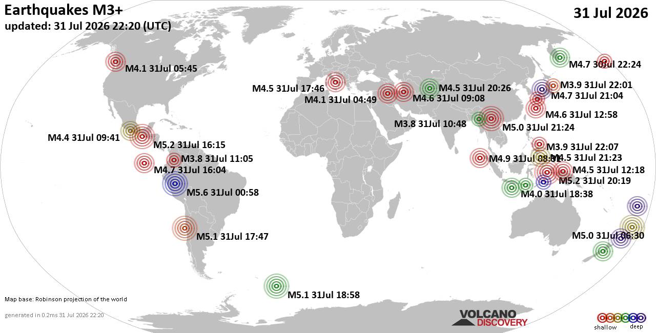 Worldwide earthquakes above magnitude 3 during the past 24 hours on 31 Jul 2026 Magnitude 5+: 10 earthquakes Magnitude 4+: 57 earthquakes Magnitude 3+: 168 earthquakes Magnitude 2+: 380 earthquakes No quakes of magnitude 6 or higher 10 largest earthquakes in the world (past 24 hours)Thursday, Jul 30, 2026, at 07:58 pm (Lima time) - Thursday, Jul 30, 2026, at 07:58 pm (Lima time) - Saturday, Aug 1, 2026, at 05:19 am (Jayapura time) - Friday, Jul 31, 2026, at 10:15 am (GMT -6) - Friday, Jul 31, 2026, at 04:58 pm (GMT -2) - Saturday, Aug 1, 2026, at 05:18 am (Jayapura time) - Friday, Jul 31, 2026, at 12:47 pm (GMT -5) - Friday, Jul 31, 2026, at 06:30 pm (GMT +12) - Friday, Jul 31, 2026, at 04:02 pm (GMT +12) - Saturday, Aug 1, 2026, at 05:24 am (Shanghai time) - Earthquakes reported feltFriday, Jul 31, 2026, at 06:46 pm (Rome time) - Friday, Jul 31, 2026, at 10:00 pm (Rome time) - Friday, Jul 31, 2026, at 01:30 am (GMT +2) - Thursday, Jul 30, 2026, at 07:58 pm (Lima time) - Friday, Jul 31, 2026, at 10:08 am (GMT -4) - Friday, Jul 31, 2026, at 01:10 pm (GMT -7) - Friday, Jul 31, 2026, at 06:15 am (GMT +3) - Friday, Jul 31, 2026, at 08:57 pm (GMT +2) - Saturday, Aug 1, 2026, at 12:09 am (Auckland time) - Friday, Jul 31, 2026, at 07:49 am (Baghdad time) - Friday, Jul 31, 2026, at 11:35 pm (GMT +2) - Friday, Jul 31, 2026, at 12:47 pm (GMT -5) - Friday, Jul 31, 2026, at 03:41 am (Mexico City time) - Friday, Jul 31, 2026, at 10:15 am (GMT -6) - Friday, Jul 31, 2026, at 03:55 pm (GMT -3) - Friday, Jul 31, 2026, at 10:24 am (Kamchatka time) - Saturday, Aug 1, 2026, at 01:56 am (Kolkata time) - Thursday, Jul 30, 2026, at 09:45 pm (Vancouver time) - Friday, Jul 31, 2026, at 04:53 am (Lima time) - Thursday, Jul 30, 2026, at 08:10 pm (GMT -5) - Friday, Jul 31, 2026, at 10:01 am (GMT -6) - Thursday, Jul 30, 2026, at 07:07 pm (GMT -4) - Friday, Jul 31, 2026, at 04:50 pm (GMT +9) - Friday, Jul 31, 2026, at 03:40 am (GMT -6) - Friday, Jul 31, 2026, at 07:43 am (GMT -4) - Friday, Jul 31, 2026, at 02:43 pm (GMT +2) - Friday, Jul 31, 2026, at 10:04 am (Santiago time) - Friday, Jul 31, 2026, at 09:55 am (GMT -6) - Friday, Jul 31, 2026, at 10:41 pm (Kolkata time) - Friday, Jul 31, 2026, at 01:29 pm (GMT -6) - Friday, Jul 31, 2026, at 01:02 pm (GMT -7) - Earthquake stats 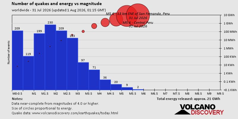 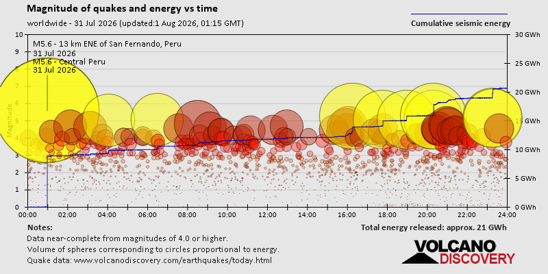 https://www.volcanodiscovery.com/earthquake/news/322388/World-Earthquake-Report-for-Friday-31-July-2026.html https://www.volcanodiscovery.com/earthquake/news/322388/World-Earthquake-Report-for-Friday-31-July-2026.html
0
7
Read More
|
Small tremor of magnitude 3.1 just reported 10 km southwest of Naples, Italy
Webmaster
Yesterday at 09:52 PM
Small tremor of magnitude 3.1 just reported 10 km southwest of Naples, Italy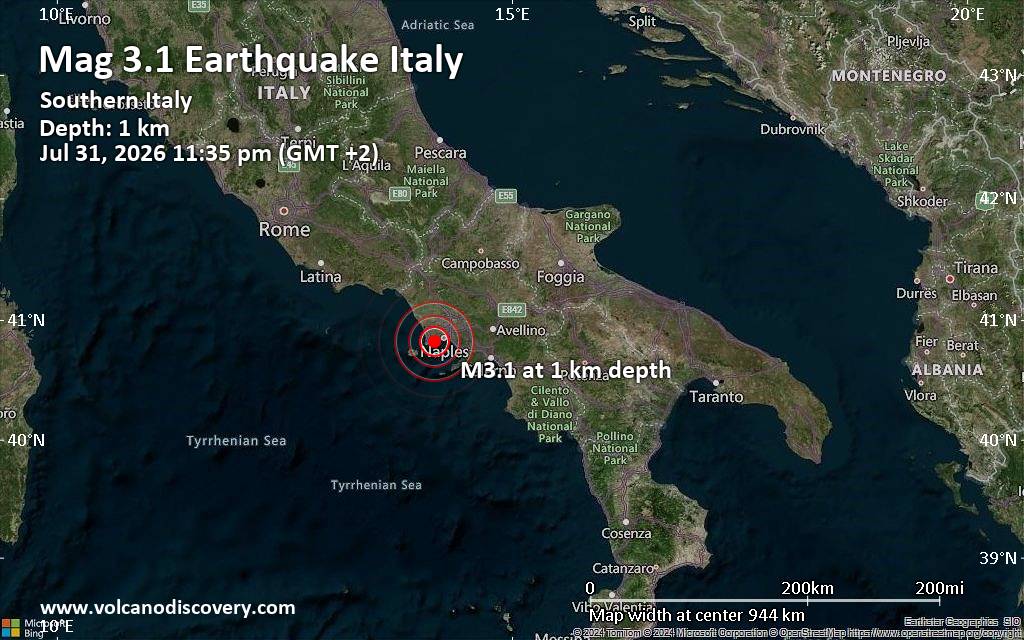 A very shallow magnitude 3.1 earthquake was reported late at night near Naples, Campania, Italy.
According to the European-Mediterranean Seismological Centre (EMSC), the quake hit on Friday, July 31st, 2026, at 11:35 pm local time at a very shallow depth of 1.40 km. Shallow earthquakes are felt more strongly than deeper ones as they are closer to the surface. The exact magnitude, epicenter, and depth of the quake might be revised within the next few hours or minutes as seismologists review data and refine their calculations, or as other agencies issue their report.
Based on the preliminary seismic data, the quake was probably felt by many people in the area of the epicenter. It should not have caused significant damage, other than objects falling from shelves, broken windows, etc.
Weak shaking might have been felt in Bagnoli (pop. 23,300) located 2 km from the epicenter, Fuorigrotta (pop. 76,500) 4 km away, Soccavo (pop. 45,300) 4 km away, Pianura (pop. 57,800) 4 km away, Pozzuoli (pop. 81,200) 5 km away, Quarto (pop. 37,700) 6 km away, Marano di Napoli (pop. 49,900) 9 km away, Naples (pop. 909,000) 10 km away, and Giugliano in Campania (pop. 80,300) 12 km away.
Earthquake data: Date & time: Jul 31, 2026 11:35 pm (GMT +2) local time (31 Jul 2026 21:35 GMT)Magnitude: 3.1 Depth: 1.40 km Epicenter latitude / longitude: 40.82°N / 14.15°E  ( Napoli, Campania, Italy) Primary data source: EMSChttps://www.volcanodiscovery.com/earthquake/news/322448/Small-tremor-of-magnitude-31-just-reported-10-km-southwest-of-Naples-Italy.html
0
11
Read More
|
Seismic-like event, possible earthquake, reported few minutes ago near Naples, Campania, Italy
Webmaster
Yesterday at 09:37 PM
Seismic-like event, possible earthquake, reported few minutes ago near Naples, Campania, Italy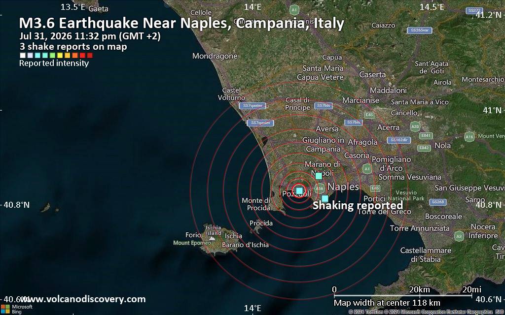 Unconfirmed quake or seismic-like event reported: Near Naples, Campania, Italy, 5 minutes ago We are receiving unverified early reports of ground shaking possibly caused by seismic activity in or near Naples, Campania, Italy on 31 Jul 2026 (GMT) at approximately 21:32 GMT.
There are no details yet on the magnitude or depth of this possible quake. If confirmed, we can expect more accurate data to emerge in the next few minutes. The location, magnitude and time mentioned are indicative, based on our best-fit seismic model. They are temporary until our AllQuakes monitoring service receives more exact scientific data from a national or international seismological agency. Check back here shortly and stay safe.
Earthquake data: Date & time: Jul 31, 2026 11:32 pm (GMT +2) local time (31 Jul 2026 21:32 GMT)Magnitude: unspecified Depth: unspecified Epicenter latitude / longitude: 40.83°N / 14.13°E ( Campania, Italy) Primary data source: VolcanoDiscoveryhttps://www.volcanodiscovery.com/earthquake/news/322446/Seismic-like-event-possible-earthquake-reported-few-minutes-ago-near-Naples-Campania-Italy.html
0
9
Read More
|
Small magnitude 3.2 earthquake 15 miles southeast of Temecula, California, United States
Webmaster
Yesterday at 08:25 PM
Small magnitude 3.2 earthquake 15 miles southeast of Temecula, California, United States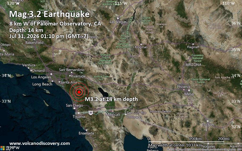 A shallow magnitude 3.2 earthquake was reported around noon near Temecula, Riverside County, California, USA.
According to the United States Geological Survey, the quake hit on Friday, July 31st, 2026, at 1:10 pm local time at a shallow depth of 8.5 miles. Shallow earthquakes are felt more strongly than deeper ones as they are closer to the surface. The exact magnitude, epicenter, and depth of the quake might be revised within the next few hours or minutes as seismologists review data and refine their calculations, or as other agencies issue their report.
Our monitoring service identified a second report from the European-Mediterranean Seismological Centre (EMSC) which listed the quake at magnitude 3.2 as well.
Weak shaking might have been felt in Aguanga (pop. 1,100) located 8 miles from the epicenter.
Other towns or cities near the epicenter where the quake might have been felt as very weak shaking include Temecula (pop. 110,000) located 15 miles from the epicenter, Escondido (pop. 151,000) 18 miles away, San Marcos (pop. 92,900) 19 miles away, Vista (pop. 100,900) 20 miles away, and Murrieta (pop. 109,800) 20 miles away. In Carlsbad (pop. 114,700, 27 miles away), Oceanside (pop. 175,700, 27 miles away), and Hemet (pop. 83,900, 27 miles away), the quake was probably not felt.
Earthquake data: Date & time: Jul 31, 2026 01:10 pm (GMT -7) local time (31 Jul 2026 20:10 GMT)Magnitude: 3.2 Depth: 13.70 km Epicenter latitude / longitude: 33.35°N / 116.95°W  ( San Diego County, California, United States) Primary data source: USGShttps://www.volcanodiscovery.com/earthquake/news/322441/Small-magnitude-32-earthquake-15-miles-southeast-of-Temecula-California-United-States.html
0
2
Read More
|
Seismic-like event, possible earthquake, reported few minutes ago near Naples, Campania, Italy
Webmaster
Yesterday at 08:02 PM
Seismic-like event, possible earthquake, reported few minutes ago near Naples, Campania, Italy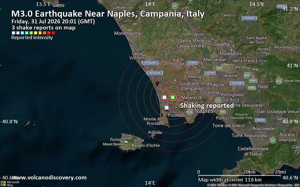 Unconfirmed quake or seismic-like event reported: Near Naples, Campania, Italy, 51 seconds ago We are receiving unverified early reports of ground shaking possibly caused by seismic activity in or near Naples, Campania, Italy on 31 Jul 2026 (GMT) at approximately 20:01 GMT.
There are no details yet on the magnitude or depth of this possible quake. If confirmed, we can expect more accurate data to emerge in the next few minutes. The location, magnitude and time mentioned are indicative, based on our best-fit seismic model. They are temporary until our AllQuakes monitoring service receives more exact scientific data from a national or international seismological agency. Check back here shortly and stay safe.
Earthquake data: Date & time: Jul 31, 2026 08:01 pm (Universal Time) local time (31 Jul 2026 20:01 GMT)Magnitude: unspecified Depth: unspecified Epicenter latitude / longitude: 40.89°N / 14.11°E ( Campania, Italy) Primary data source: VolcanoDiscoveryhttps://www.volcanodiscovery.com/earthquake/news/322439/Seismic-like-event-possible-earthquake-reported-few-minutes-ago-near-Naples-Campania-Italy.html
0
2
Read More
|
Seismic-like event, possible earthquake, reported few minutes ago near Naples, Campania, Italy
Webmaster
Yesterday at 07:01 PM
Seismic-like event, possible earthquake, reported few minutes ago near Naples, Campania, Italy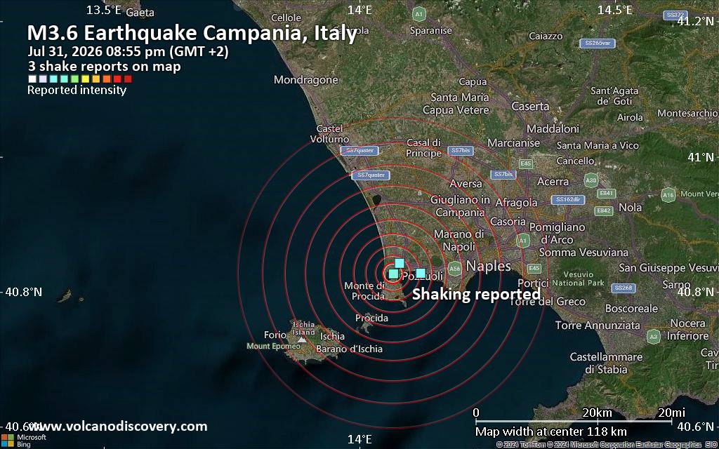 Unconfirmed quake or seismic-like event reported: 17 km west of Naples, Napoli, Campania, Italy, 6 minutes ago We are receiving unverified early reports of ground shaking possibly caused by seismic activity in or near Naples, Campania, Italy on 31 Jul 2026 (GMT) at approximately 18:55 GMT.
There are no details yet on the magnitude or depth of this possible quake. If confirmed, we can expect more accurate data to emerge in the next few minutes. The location, magnitude and time mentioned are indicative, based on our best-fit seismic model. They are temporary until our AllQuakes monitoring service receives more exact scientific data from a national or international seismological agency. Check back here shortly and stay safe.
Earthquake data: Date & time: Jul 31, 2026 08:55 pm (GMT +2) local time (31 Jul 2026 18:55 GMT)Magnitude: unspecified Depth: unspecified Epicenter latitude / longitude: 40.83°N / 14.07°E ( Campania, Italy) Primary data source: VolcanoDiscoveryhttps://www.volcanodiscovery.com/earthquake/news/322437/Seismic-like-event-possible-earthquake-reported-few-minutes-ago-near-Naples-Campania-Italy.html
0
2
Read More
|
World Earthquake Report for July 2026
Webmaster
Yesterday at 06:00 PM
World Earthquake Report for July 2026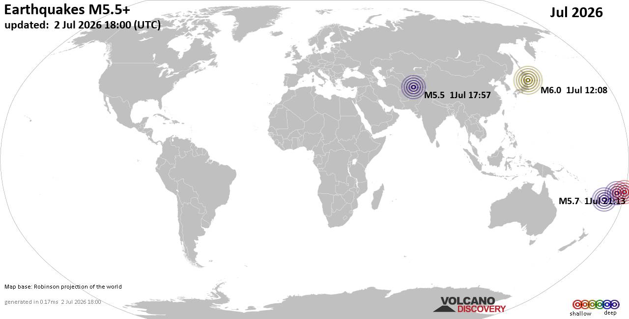 Worldwide earthquakes above magnitude 5.5 during July 2026 Magnitude 9+: none Magnitude 8+: none Magnitude 7+: 1 earthquake Magnitude 6+: 10 earthquakes Magnitude 5+: 238 earthquakes Magnitude 4+: 1918 earthquakes Magnitude 3+: 6385 earthquakes Magnitude 2+: 11980 earthquakes No quakes of magnitude 8 or higher List of 10 largest earthquakes in the world during July 2026:Friday, Jul 17, 2026, at 08:48 am (GMT -6) - Friday, Jul 17, 2026, at 09:20 am (GMT -6) - Monday, Jul 13, 2026, at 06:53 pm (GMT +10) - Saturday, Jul 11, 2026, at 08:26 am (GMT -2) - Tuesday, Jul 14, 2026, at 01:45 am (GMT +11) - Friday, Jul 3, 2026, at 11:31 am (Jayapura time) - Tuesday, Jul 14, 2026, at 11:49 pm (Manila time) - Friday, Jul 3, 2026, at 01:04 pm (GMT +9) - Wednesday, Jul 1, 2026, at 09:08 pm (GMT +9) - Thursday, Jul 16, 2026, at 10:14 pm (Auckland time) - Earthquake stats: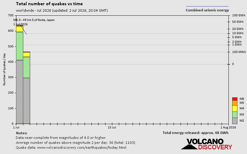 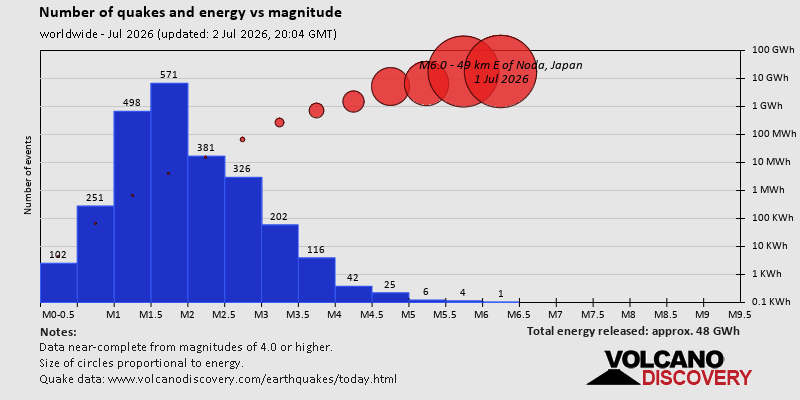 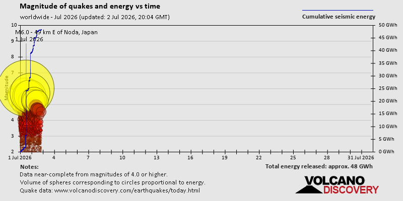 https://www.volcanodiscovery.com/view_news/318265/World-Earthquake-Report-for-July-2026.html https://www.volcanodiscovery.com/view_news/318265/World-Earthquake-Report-for-July-2026.html
0
3
Read More
|
Significant magnitude 5.2 earthquake 82 km west of La Serena, Chile
Webmaster
Yesterday at 05:58 PM
Significant magnitude 5.2 earthquake 82 km west of La Serena, Chile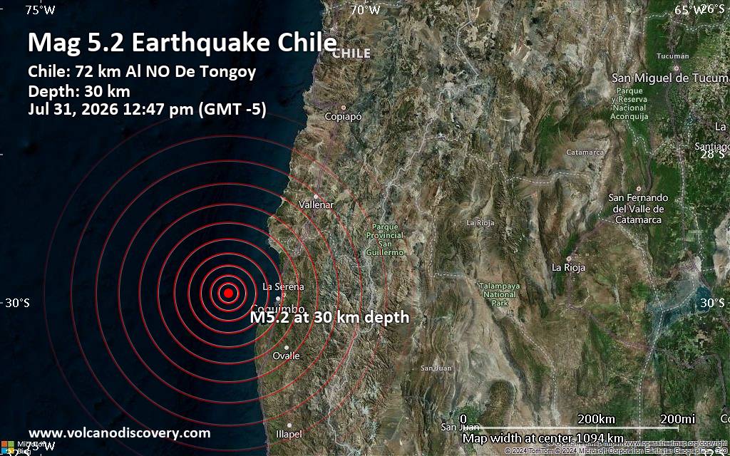 An earthquake of magnitude 5.2 occurred around noon on Friday, July 31st, 2026, at 12:47 pm local time near La Serena, Provincia de Elqui, Region de Coquimbo, Chile, as reported by The National Seismological Center (Centro Sismológico Nacional, CSN) of the University of Chile.
According to preliminary data, the quake was located at a moderately shallow depth of 30. km. The exact magnitude, epicenter, and depth of the quake might be revised within the next few hours or minutes as seismologists review data and refine their calculations, or as other agencies issue their report.
Based on the preliminary seismic data, the quake should not have caused any significant damage, but was probably felt by many people as light vibration in the area of the epicenter.
Weak shaking might have been felt in Coquimbo (pop. 161,300) located 74 km from the epicenter, La Serena (pop. 154,500) 82 km away, La Higuera (pop. 4,300) 96 km away, and Ovalle (pop. 77,100) 118 km away.
VolcanoDiscovery will automatically update magnitude and depth if these change and follow up if other significant news about the quake become available. If you’re in the area, please send us your experience through our reporting mechanism, either online or via our mobile app. This will help us provide more first-hand updates to anyone around the globe who wants to know more about this quake.
Earthquake data: Date & time: Jul 31, 2026 05:47 pm (Universal Time) local time (31 Jul 2026 17:47 GMT)Magnitude: 5.2 Depth: 10.00 km Epicenter latitude / longitude: 29.91°S / 72.15°W  ( Region de Coquimbo, Chile) Primary data source: EMSChttps://www.volcanodiscovery.com/earthquake/news/322433/Significant-magnitude-52-earthquake-82-km-west-of-La-Serena-Chile.html
0
2
Read More
|
Moderate 4.3 quake hits near Naples, Campania, Italy
Webmaster
Yesterday at 05:52 PM
Moderate 4.3 quake hits near Naples, Campania, Italy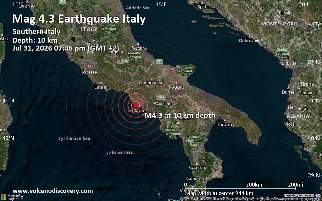 A magnitude 4.3 earthquake near Naples, Campania, Italy, was reported only 4 minutes ago by the German Research Centre for Geosciences (GFZ), considered one of the key international agencies that monitor seismic activity worldwide. The earthquake occurred at a shallow depth of 10. km beneath the epicenter early evening on Friday, July 31st, 2026, at 7:46 pm local time. The exact magnitude, epicenter, and depth of the quake might be revised within the next few hours or minutes as seismologists review data and refine their calculations, or as other agencies issue their report.
Based on the preliminary seismic data, the quake was probably felt by many people in the area of the epicenter. It should not have caused significant damage, other than objects falling from shelves, broken windows, etc.
Weak shaking might have been felt in Quarto (pop. 37,700) located 2 km from the epicenter, Monterusciello (pop. 29,100) 3 km away, Pozzuoli (pop. 81,200) 4 km away, Pianura (pop. 57,800) 5 km away, Marano di Napoli (pop. 49,900) 6 km away, Soccavo (pop. 45,300) 7 km away, Fuorigrotta (pop. 76,500) 8 km away, Giugliano in Campania (pop. 80,300) 9 km away, and Naples (pop. 909,000) 13 km away.
VolcanoDiscovery will automatically update magnitude and depth if these change and follow up if other significant news about the quake become available. If you’re in the area, please send us your experience through our reporting mechanism, either online or via our mobile app. This will help us provide more first-hand updates to anyone around the globe who wants to know more about this quake.
Earthquake data: Date & time: Jul 31, 2026 07:46 pm (Rome time) local time (31 Jul 2026 17:46 GMT)Magnitude: 4.3 Depth: 10.00 km Epicenter latitude / longitude: 40.87°N / 14.12°E ( Napoli, Campania, Italy) Primary data source: GFZhttps://www.volcanodiscovery.com/earthquake/news/322431/Moderate-43-quake-hits-near-Naples-Campania-Italy.html
0
2
Read More
|
Small tremor of magnitude 3.3 just reported 23 miles south of Baie-Comeau, Quebec, Canada
Webmaster
Yesterday at 02:37 PM
Small tremor of magnitude 3.3 just reported 23 miles south of Baie-Comeau, Quebec, Canada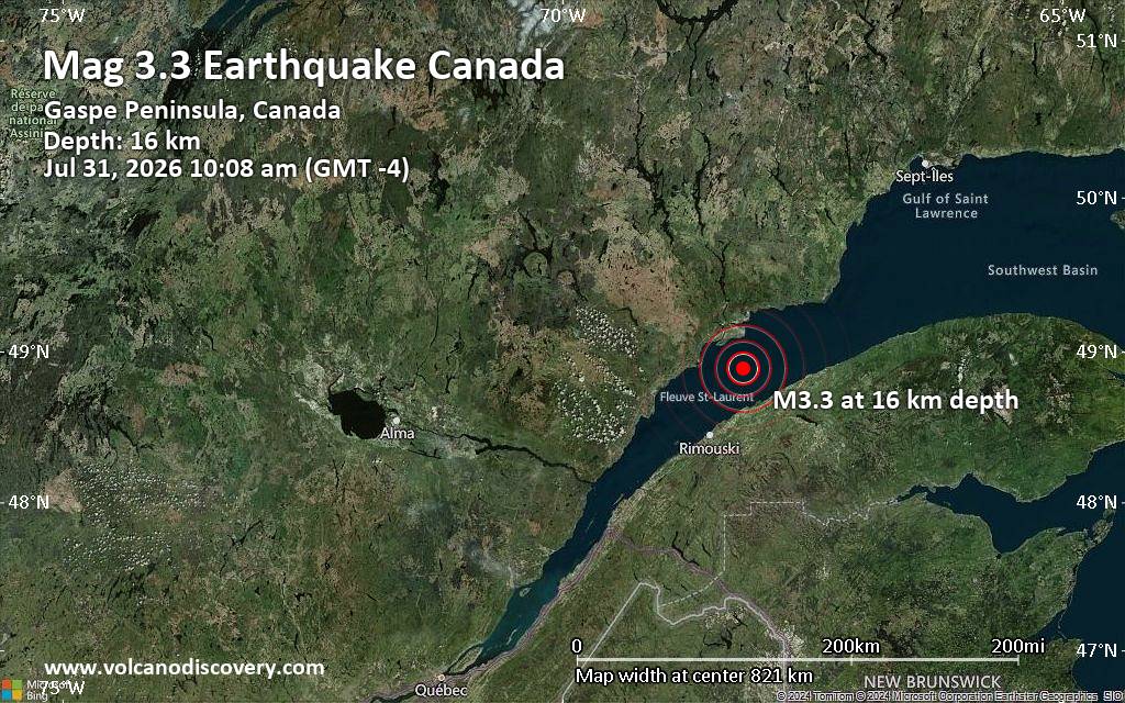 An earthquake of magnitude 3.3 occurred only 28 minutes ago 23 miles south of Baie-Comeau, Quebec, Canada, the citizen-seismograph network of RaspberryShake reported.
The quake hit at a shallow depth of 9.9 miles beneath the epicenter near Baie-Comeau, Côte-Nord, Quebec, Canada, in the morning on Friday, July 31st, 2026, at 10:08 am local time. The exact magnitude, epicenter, and depth of the quake might be revised within the next few hours or minutes as seismologists review data and refine their calculations, or as other agencies issue their report.
Towns or cities near the epicenter where the quake might have been felt as very weak shaking include Chute-aux-Outardes (pop. 2,000) located 18 miles from the epicenter, Betsiamites (pop. 2,400) 21 miles away, Mont-Joli (pop. 6,600) 21 miles away, Hauterive (pop. 11,500) 21 miles away, Baie-Comeau (pop. 21,500) 23 miles away, and Saint-Ulric (pop. 1,600) 23 miles away. In Matane (pop. 14,800, 31 miles away), and Rimouski (pop. 42,200, 34 miles away), the quake was probably not felt.
Earthquake data: Date & time: Jul 31, 2026 02:08 pm (Universal Time) local time (31 Jul 2026 14:08 GMT)Magnitude: 3.1 Depth: 16.00 km Epicenter latitude / longitude: 48.89°N / 68.19°W  (Cote-Nord, Quebec, Canada) Primary data source: RaspberryShakehttps://www.volcanodiscovery.com/earthquake/news/322422/Small-tremor-of-magnitude-33-just-reported-23-miles-south-of-Baie-Comeau-Quebec-Canada.html
0
2
Read More
|
Seismic-like event, possible earthquake, reported few minutes ago near Baie-Comeau, Quebec, Canada
Webmaster
Yesterday at 02:14 PM
Seismic-like event, possible earthquake, reported few minutes ago near Baie-Comeau, Quebec, Canada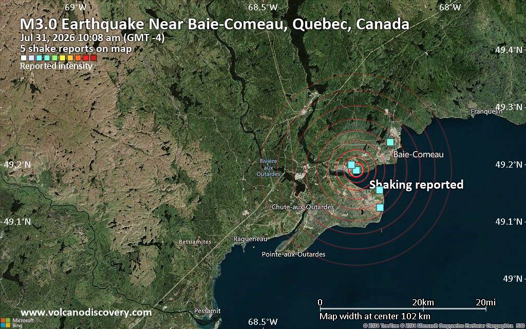 Unconfirmed quake or seismic-like event reported: Near Baie-Comeau, Quebec, Canada, 5 minutes ago We are receiving unverified early reports of ground shaking possibly caused by seismic activity in or near Baie-Comeau, Quebec, Canada on 31 Jul 2026 (GMT) at approximately 14:08 GMT.
There are no details yet on the magnitude or depth of this possible quake. If confirmed, we can expect more accurate data to emerge in the next few minutes. The location, magnitude and time mentioned are indicative, based on our best-fit seismic model. They are temporary until our AllQuakes monitoring service receives more exact scientific data from a national or international seismological agency. Check back here shortly and stay safe.
Earthquake data: Date & time: Jul 31, 2026 10:08 am (GMT -4) local time (31 Jul 2026 14:08 GMT)Magnitude: unspecified Depth: unspecified Epicenter latitude / longitude: 49.19°N / 68.25°W ( Quebec, Canada) Primary data source: VolcanoDiscoveryhttps://www.volcanodiscovery.com/earthquake/news/322418/Seismic-like-event-possible-earthquake-reported-few-minutes-ago-near-Baie-Comeau-Quebec-Canada.html
0
2
Read More
|
Moderate 4.5 quake hits near Sarmi, Sarmi Regency, Provinsi Papua, Indonesia
Webmaster
Yesterday at 12:46 PM
Moderate 4.5 quake hits near Sarmi, Sarmi Regency, Provinsi Papua, Indonesia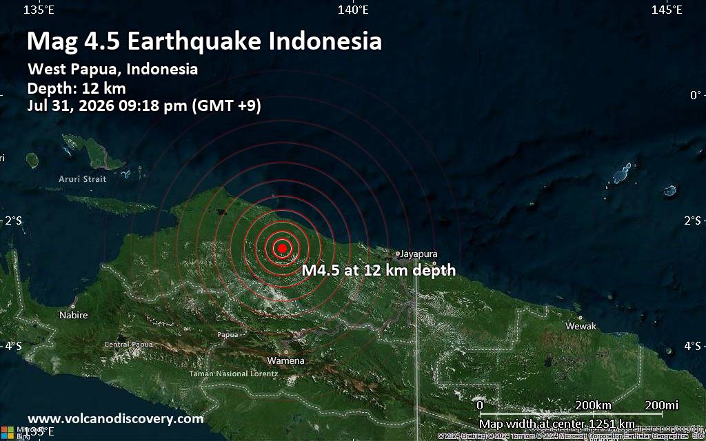 A shallow magnitude 4.5 earthquake was reported in the evening near Sarmi, Sarmi Regency, Provinsi Papua, Indonesia.
According to Indonesia's Meteorology, Climatology, and Geophysical Agency, the quake hit on Friday, July 31st, 2026, at 9:18 pm local time at a shallow depth of 12. km. Shallow earthquakes are felt more strongly than deeper ones as they are closer to the surface. The exact magnitude, epicenter, and depth of the quake might be revised within the next few hours or minutes as seismologists review data and refine their calculations, or as other agencies issue their report.
Our monitoring service identified a second report from the citizen-seismograph network of RaspberryShake which listed the quake at magnitude 2.8.
Weak shaking might have been felt in Sarmi (pop. 14,100) located 67 km from the epicenter.
VolcanoDiscovery will automatically update magnitude and depth if these change and follow up if other significant news about the quake become available. If you’re in the area, please send us your experience through our reporting mechanism, either online or via our mobile app. This will help us provide more first-hand updates to anyone around the globe who wants to know more about this quake.
Earthquake data: Date & time: Jul 31, 2026 09:18 pm (GMT +9) local time (31 Jul 2026 12:18 GMT)Magnitude: 4.5 Depth: 12.00 km Epicenter latitude / longitude: 2.44°S / 138.87°E  ( Kabupaten Sarmi, South Papua, Indonesia) Primary data source: BMKGhttps://www.volcanodiscovery.com/earthquake/news/322414/Moderate-45-quake-hits-near-Sarmi-Sarmi-Regency-Provinsi-Papua-Indonesia.html
0
2
Read More
|
Sunday: Sunny Intervals, Minimum Temperature: 15°C (58°F) Maximum Temperature: 23°C (74°F)
Webmaster
Yesterday at 06:00 AM
Maximum Temperature: 23°C (74°F), Minimum Temperature: 15°C (58°F), Wind Direction: south-westerly, Wind Speed: 2mph, Visibility: Very Good, Pressure: 1019mb, Humidity: 57%, UV Risk: 5, Pollution: Low, Sunrise: 05:26 BST, Sunset: 21:04 BST Source: Sunday: Sunny Intervals, Minimum Temperature: 15°C (58°F) Maximum Temperature: 23°C (74°F)
0
33
Read More
|
Saturday: Sunny Intervals, Minimum Temperature: 10°C (50°F) Maximum Temperature: 20°C (68°F)
Webmaster
Yesterday at 06:00 AM
Maximum Temperature: 20°C (68°F), Minimum Temperature: 10°C (50°F), Wind Direction: westerly, Wind Speed: 9mph, Visibility: Good, Pressure: 1020mb, Humidity: 63%, UV Risk: 5, Pollution: Low, Sunrise: 05:24 BST, Sunset: 21:06 BST Source: Saturday: Sunny Intervals, Minimum Temperature: 10°C (50°F) Maximum Temperature: 20°C (68°F)
0
31
Read More
|
Today: Light Rain, Minimum Temperature: 11°C (51°F) Maximum Temperature: 20°C (68°F)
Webmaster
Yesterday at 06:00 AM
Maximum Temperature: 20°C (68°F), Minimum Temperature: 11°C (51°F), Wind Direction: westerly, Wind Speed: 10mph, Visibility: Good, Pressure: 1019mb, Humidity: 59%, UV Risk: 6, Pollution: Low, Sunrise: 05:22 BST, Sunset: 21:07 BST Source: Today: Light Rain, Minimum Temperature: 11°C (51°F) Maximum Temperature: 20°C (68°F)
0
30
Read More
|
|
Forums60
Topics793,504
Posts828,287
Members2,960
| |
Most Online102,106
Jul 10th, 2026
|
|
|
|
|
Copyright 1996 - 2026 by David Cottle. Designed by David Bate Jr. All Rights Reserved.
By using this forum, the user agrees not to transfer any data or technical information received under this agreement to any other entity without the express approval of the AUS-CITY Forum Admins and/or authors of individual posts (Forum Admins and DoD/USSPACECOM for the analysis of satellite tracking data).
Two-line elements (TLE) and all other satellite data presented and distributed via this forum and AUS-CITY mailing lists are distributed with permission from DoD/USSTRATCOM.


|

|


 - Click image for larger picture.")


