|
|
|
0 members (),
1,975
guests, and
29
robots. |
|
Key:
Admin,
Global Mod,
Mod
|
|
S |
M |
T |
W |
T |
F |
S |
|
|
|
1
|
2
|
3
|
4
|
5
|
|
6
|
7
|
8
|
9
|
10
|
11
|
12
|
|
13
|
14
|
15
|
16
|
17
|
18
|
19
|
|
20
|
21
|
22
|
23
|
24
|
25
|
26
|
|
27
|
28
|
29
|
30
|
|
|
|
|
There are no members with birthdays on this day. |
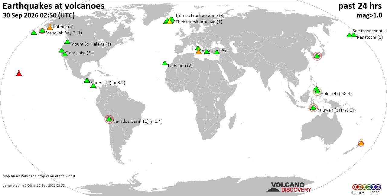
Volcano earthquake report for Wednesday, 30 September 2026
• Strong mag. 5.7 earthquake - 69 km Al Suroeste De Rosario, Costa Rica, on 2...
• M 0.9 - 4 km W of Devore, CA
• M 4.6 - 131 km SE of Itoman, Japan
• M -1.1 - 66 km ENE of Pedro Bay, Alaska
• M 1.6 - 8 km ESE of Cloverdale, CA
• M 3.0 - 8 km ESE of Cloverdale, CA
|
 SPC MD 2339
Webmaster
1 hour ago
SPC MD 2339
Webmaster
1 hour ago
SPC MD 2339MD 2339 CONCERNING SEVERE POTENTIAL...WATCH UNLIKELY FOR NORTHEASTERN NEW MEXICO INTO THE OKLAHOMA/TEXAS PANHANDLES 
Mesoscale Discussion 2339
NWS Storm Prediction Center Norman OK
0356 PM CDT Wed Sep 30 2026

Areas affected...northeastern New Mexico into the Oklahoma/Texas
Panhandles

Concerning...Severe potential...Watch unlikely

Valid 302056Z - 302300Z

Probability of Watch Issuance...20 percent

SUMMARY...A few low topped storms may produce instances of
marginally severe hail and strong to sever wind this
afternoon/evening.

DISCUSSION...Cooling mid-level temperatures and increasing forcing
for ascent with the trough behind the surface low across New Mexico
is leading to gradual destabilization and increase in thunderstorm
activity across northeastern New Mexico. Moisture is somewhat
limited to the west across New Mexico, with low to mid 50s dew
points, improving with eastward extent into the OK/TX panhandles
with around 250-500 J/kg of MLCAPE. This fairly marginal instability
will be sufficient, given strong deep layer shear, for a few
low-topped storms/transient supercells capable of marginally severe
hail and strong to severe wind. This will shift eastward into the
panhandles with time this evening. Overall, this potential looks to
remain fairly isolated and watch issuance is not anticipated.

..Thornton/Mosier.. 09/30/2026

...Please see www.spc.noaa.gov for graphic product...

ATTN...WFO...DDC...AMA...PUB...ABQ...

LAT...LON   35970449 36350440 37240294 37530185 37430122 37050085
            36690069 36350072 36130093 35600233 35320339 35310404
            35970449

MOST PROBABLE PEAK TORNADO INTENSITY...UP TO 90 MPH
MOST PROBABLE PEAK WIND GUST...UP TO 60 MPH
MOST PROBABLE PEAK HAIL SIZE...UP TO 1.25 IN
Read morehttps://www.spc.noaa.gov/products/md/md2339.html
0
5
Read More
|
SPC MD 2340
Webmaster
1 hour ago
SPC MD 2340MD 2340 CONCERNING SEVERE POTENTIAL...WATCH UNLIKELY FOR PARTS OF NORTHERN OKLAHOMA INTO SOUTHEAST KANSAS 
Mesoscale Discussion 2340
NWS Storm Prediction Center Norman OK
0500 PM CDT Wed Sep 30 2026

Areas affected...parts of northern Oklahoma into southeast Kansas

Concerning...Severe potential...Watch unlikely

Valid 302200Z - 010030Z

Probability of Watch Issuance...20 percent

SUMMARY...Scattered storms may persist from parts of central into
northern Oklahoma and southeast Kansas. A storm or two may exhibit
rotation with a brief/weak tornado not out of the question.

DISCUSSION...Scattered storms have developed within within the warm
sector from northern TX across central OK, with additional activity
extending into east-central KS. While the primary large-scale lift
will remain to the north of these areas, south/southwest 850 mb
winds are forecast to increase to over 40 kt this evening.
Currently, the TLX VWP shows 0-1 SRH around 125 m2/s2, with larger
values farther north to 300 m2/s2 at ICT.

Given a few hours of scattered storms within this corridor, and
areas of stronger low-level shear (especially into KS), a brief
tornado cannot be ruled out if a more robust cell can develop.

..Jewell/Hart.. 09/30/2026

...Please see www.spc.noaa.gov for graphic product...

ATTN...WFO...TSA...TOP...ICT...OUN...

LAT...LON   35529789 37929712 38219663 38279574 38089556 37919546
            37469555 36149594 35509625 35169661 35139755 35239778
            35529789

MOST PROBABLE PEAK TORNADO INTENSITY...UP TO 90 MPH
MOST PROBABLE PEAK WIND GUST...UP TO 60 MPH
Read morehttps://www.spc.noaa.gov/products/md/md2340.html
0
5
Read More
|
Friday: Thundery Showers, Minimum Temperature: 13°C (55°F) Maximum Temperature: 19°C (66°F)
Webmaster
1 hour ago
Maximum Temperature: 19°C (66°F), Minimum Temperature: 13°C (55°F), Wind Direction: southerly, Wind Speed: 10mph, Visibility: Good, Pressure: 1025mb, Humidity: 81%, UV Risk: 2, Pollution: Low, Sunrise: 07:13 BST, Sunset: 18:42 BST Source: Friday: Thundery Showers, Minimum Temperature: 13°C (55°F) Maximum Temperature: 19°C (66°F)
0
6
Read More
|
Thursday: Sunny Intervals, Minimum Temperature: 10°C (50°F) Maximum Temperature: 18°C (65°F)
Webmaster
1 hour ago
Maximum Temperature: 18°C (65°F), Minimum Temperature: 10°C (50°F), Wind Direction: south-westerly, Wind Speed: 5mph, Visibility: Moderate, Pressure: 1021mb, Humidity: 74%, UV Risk: 4, Pollution: Low, Sunrise: 07:12 BST, Sunset: 18:44 BST Source: Thursday: Sunny Intervals, Minimum Temperature: 10°C (50°F) Maximum Temperature: 18°C (65°F)
0
4
Read More
|
|
Forums60
Topics850,006
Posts884,801
Members2,960
| |
Most Online102,106
Jul 10th, 2026
|
|
|
|
|

|