|
|
|
0 members (),
2,331
guests, and
24
robots. |
|
Key:
Admin,
Global Mod,
Mod
|
|
S |
M |
T |
W |
T |
F |
S |
|
|
|
|
1
|
2
|
3
|
4
|
|
5
|
6
|
7
|
8
|
9
|
10
|
11
|
|
12
|
13
|
14
|
15
|
16
|
17
|
18
|
|
19
|
20
|
21
|
22
|
23
|
24
|
25
|
|
26
|
27
|
28
|
29
|
30
|
|
|
|
There are no members with birthdays on this day. |
|
|
SPC MD 387
by Webmaster - Sun 12 Apr 2026 07:21:PM
|
SPC MD 388
by Webmaster - Sun 12 Apr 2026 07:21:PM
|
SPC MD 389
by Webmaster - Sun 12 Apr 2026 07:21:PM
|
|
|
|
|
|
|
|
|
|
|
|
|
|
|
Joined: Feb 2001
Posts: 381,904
Launch Director
|
OP

Launch Director
Joined: Feb 2001
Posts: 381,904 |
SPC MD 387MD 0387 CONCERNING SEVERE POTENTIAL...WATCH UNLIKELY FOR PARTS OF CENTRAL AND SOUTHEASTERN TEXAS 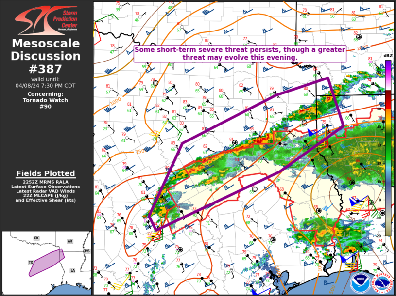
Mesoscale Discussion 0387
NWS Storm Prediction Center Norman OK
1252 PM CDT Sun Apr 12 2026

Areas affected...parts of central and southeastern Texas

Concerning...Severe potential...Watch unlikely

Valid 121752Z - 122015Z

Probability of Watch Issuance...5 percent

SUMMARY...Strong thunderstorm development may persist into the 4-6
PM CDT time frame, perhaps accompanied by some risk for a brief
tornado, and a few strong surface gusts before storms diminish.

DISCUSSION...Moderate southerly return flow persists across the
middle Texas coastal plain, near the southern periphery of a belt of
40-50 kt southwesterly 500 mb flow extending from south of the Texas
Big Bend through the southeastern Great Plains.  One short wave
impulse embedded within this regime now appears to be shifting
across/northwest of the Ark-La-Texas vicinity, with perhaps an even
more subtle perturbation/associated speed maximum still upstream and
forecast to propagate across central Texas through mid to late
afternoon.

Likely aided by inflow of moist boundary-layer characterized by
surface dew points around 70F, which appears to be contributing to
CAPE on the order of 1500 J/kg, vigorous convective development to
the north-northwest of Victoria has been exhibiting transient
supercell structure the past couple of hours.  This appears to
focused near a lingering 30+ kt southerly 850 mb jet axis, which
various model output suggests may still undergo some strengthening
into mid/late afternoon.  As this occurs, the aforementioned
convection and trailing storms developing to the southwest may
undergo further intensification and upscale growth.

This may be accompanied by at least some risk for a brief tornado.
With forecast soundings indicating near saturated profiles through a
fairly deep surface-based layer, the risk for damaging wind gusts
may be initially hindered, but, with time, this potential could
gradually increase with heavy precipitation loading and further
upscale convective growth.

..Kerr/Mosier.. 04/12/2026

...Please see www.spc.noaa.gov for graphic product...

ATTN...WFO...HGX...CRP...EWX...

LAT...LON   28349792 29269779 30349679 30349626 29909574 29159676
            28349792

MOST PROBABLE PEAK TORNADO INTENSITY...UP TO 95 MPH
MOST PROBABLE PEAK WIND GUST...55-70 MPH
MOST PROBABLE PEAK HAIL SIZE...UP TO 1.25 IN
Read morehttps://www.spc.noaa.gov/products/md/md0387.html
|
|


CMS The Best Conveyancing solicitors conveyancing quotes throughout the UK
For any webhosting enquiries please email webmaster@aus-city.com
|
|
Forums60
Topics768,776
Posts803,542
Members2,958
| |
Most Online17,963
Jan 15th, 2026
|
|
|
|
|
Copyright 1996 - 2026 by David Cottle. Designed by David Bate Jr. All Rights Reserved.
By using this forum, the user agrees not to transfer any data or technical information received under the agreement, to any other entity without the express approval of the AUS-CITY Forum Admins and/or authors of individual posts (Forum Admins and DoD/USSPACECOM for the analysis of satellite tracking data).
Two-line elements (TLE) and all other satellite data presented and distributed via this forum and e-mail lists of AUS-CITY are distributed with permission from DoD/USSTRATCOM.

Reprise Hosting

|

|


 - Click image for larger picture.")


