|
|
|
0 members (),
2,037
guests, and
25
robots. |
|
Key:
Admin,
Global Mod,
Mod
|
|
S |
M |
T |
W |
T |
F |
S |
|
1
|
2
|
3
|
4
|
5
|
6
|
7
|
|
8
|
9
|
10
|
11
|
12
|
13
|
14
|
|
15
|
16
|
17
|
18
|
19
|
20
|
21
|
|
22
|
23
|
24
|
25
|
26
|
27
|
28
|
|
29
|
30
|
31
|
|
|
|
|
|
There are no members with birthdays on this day. |
 SPC MD 154
Webmaster
4 hours ago
SPC MD 154
Webmaster
4 hours ago
SPC MD 154MD 0154 CONCERNING SEVERE THUNDERSTORM WATCH 17... FOR NORTHERN INDIANA INTO SOUTHERN MICHIGAN 
Mesoscale Discussion 0154
NWS Storm Prediction Center Norman OK
0637 PM CST Fri Mar 06 2026

Areas affected...Northern Indiana into southern Michigan

Concerning...Severe Thunderstorm Watch 17...

Valid 070037Z - 070230Z

The severe weather threat for Severe Thunderstorm Watch 17
continues.

SUMMARY...A squall line will continue east across northern Indiana
and southern lower Michigan for the next couple of hours before
gradually weakening. Damaging gusts remain the primary threat.

DISCUSSION...Latest MRMS and GOES IR imagery continue to show new
updraft development within a squall line draped from southern MI
into northwest IN, and local radar imagery continues to show a few
bowing segments within the line. Regional VWPs and latest RAP
mesoanalysis continues to show a strongly sheared environment in
place across the region with 0-3 km BWD values on the order of 30-40
knots and 40-50 knots winds within the lowest kilometer. This
kinematic environment will continue to support the potential for
organized/bowing segments within the line with an attendant threat
for severe/damaging winds - especially with any
meridionally-oriented segments. With time, a gradual weakening trend
is expected as the squall line outpaces the axis of better
surface-based buoyancy draped from western IL into northern IN. The
onset of nocturnal cooling will further contribute to an overall
reduction in convective intensity in the coming hours.

..Moore.. 03/07/2026

...Please see www.spc.noaa.gov for graphic product...

ATTN...WFO...DTX...IWX...GRR...IND...LOT...

LAT...LON   40888772 41418696 41968605 42408539 43018453 42998411
            42818366 42548353 42258366 41478464 41108518 40858569
            40688634 40668681 40658709 40678735 40698751 40758766
            40888772

MOST PROBABLE PEAK TORNADO INTENSITY...UP TO 95 MPH
MOST PROBABLE PEAK WIND GUST...UP TO 60 MPH
MOST PROBABLE PEAK HAIL SIZE...UP TO 1.25 IN
Read morehttps://www.spc.noaa.gov/products/md/md0154.html
0
9
Read More
|
SPC MD 155
Webmaster
4 hours ago
SPC MD 155MD 0155 CONCERNING TORNADO WATCH 16... FOR EASTERN NEBRASKA INTO WESTERN IOWA 
Mesoscale Discussion 0155
NWS Storm Prediction Center Norman OK
0712 PM CST Fri Mar 06 2026

Areas affected...Eastern Nebraska into western Iowa

Concerning...Tornado Watch 16...

Valid 070112Z - 070315Z

The severe weather threat for Tornado Watch 16 continues.

SUMMARY...Elevated thunderstorms to the north of a cold front will
continue to pose a large to very large hail threat for the next
several hours.

DISCUSSION...Elevated thunderstorms developing to the north of a
surging cold front have produced hail stones ranging from 1 to 2
inches over the past hour. Although radar presentation of these
cells has been somewhat meager, the 00z OAX sounding sampled 1250
J/kg MUCAPE above the frontal surface and an elongated hodograph
characterized by effective bulk shear on the order of 50 knots. This
environment is very favorable for splitting supercells capable of
producing large/very large hail. Per latest RAP mesoanalysis
estimates, this environment extends eastward into western IA, and
additional cells are noted developing within the post-frontal regime
across eastern NE/western IA. These trends suggest that the threat
for large hail is likely increasing, though it remains somewhat
unclear how long storm mode will remain discrete/semi-discrete
downstream. Regardless, additionally watch issuance may be needed in
the coming hours to address this threat if the developing cells
remain highly efficient at hail production.

..Moore.. 03/07/2026

...Please see www.spc.noaa.gov for graphic product...

ATTN...WFO...DMX...EAX...FSD...OAX...TOP...GID...

LAT...LON   39919673 39909722 40159761 40669771 42049748 42329722
            42469693 43269450 43189395 42979361 42679350 42289374
            41969408 40889529 40059641 39919673

MOST PROBABLE PEAK TORNADO INTENSITY...UP TO 95 MPH
MOST PROBABLE PEAK WIND GUST...UP TO 60 MPH
MOST PROBABLE PEAK HAIL SIZE...1.50-2.50 IN
Read morehttps://www.spc.noaa.gov/products/md/md0155.html
0
8
Read More
|
SPC MD 156
Webmaster
4 hours ago
SPC MD 156MD 0156 CONCERNING TORNADO WATCH 15...18... FOR NORTHEAST OKLAHOMA TO WEST-CENTRAL MISSOURI 
Mesoscale Discussion 0156
NWS Storm Prediction Center Norman OK
0743 PM CST Fri Mar 06 2026

Areas affected...Northeast Oklahoma to West-Central Missouri

Concerning...Tornado Watch 15...18...

Valid 070143Z - 070315Z

The severe weather threat for Tornado Watch 15, 18 continues.

SUMMARY...Supercell threat, with isolated tornadoes, continues this
evening.

DISCUSSION...Complex mode of convection has evolved from northeast
OK into west-central MO. Strong low-level warm advection is noted
along this corridor, coincident with the LLJ. VWP data from
INX/SGF/EAX all exhibit 0-3 SRH values in excess of 400 m2/s2, and
ample buoyancy was noted on the 00z soundings from SGF/TOP/OUN. OUN
was particularly noteworthy with 2100 J/kg MLCAPE and negligible
inhibition. Latest radar data depicts at least two long-lived
supercells over northeast OK, embedded within a broader mixed-mode
elongated convective band. This activity will continue to
spread/develop northeast, along with an attendant risk for tornadoes
and perhaps some large hail.

..Darrow.. 03/07/2026

...Please see www.spc.noaa.gov for graphic product...

ATTN...WFO...SGF...EAX...TSA...ICT...

LAT...LON   35679631 38559447 38709303 37289384 35569533 35679631

MOST PROBABLE PEAK TORNADO INTENSITY...120-150 MPH
MOST PROBABLE PEAK WIND GUST...55-70 MPH
MOST PROBABLE PEAK HAIL SIZE...1.50-2.50 IN
Read morehttps://www.spc.noaa.gov/products/md/md0156.html
0
9
Read More
|
SPC Tornado Watch 19
Webmaster
4 hours ago
SPC Tornado Watch 19WW 19 TORNADO IA IL KS MO 070215Z - 071000Z 
URGENT - IMMEDIATE BROADCAST REQUESTED
Tornado Watch Number 19
NWS Storm Prediction Center Norman OK
815 PM CST Fri Mar 6 2026

The NWS Storm Prediction Center has issued a

* Tornado Watch for portions of
  Eastern Iowa
  Extreme Northwest Illinois
  East-Central Kansas
  Northern Missouri

* Effective this Friday night and Saturday morning from 815 PM
  until 400 AM CST.

* Primary threats include...
  A few tornadoes likely with a couple intense tornadoes possible
  Scattered large hail and isolated very large hail events to 2
    inches in diameter likely
  Scattered damaging wind gusts to 70 mph likely

SUMMARY...Multiple clusters of thunderstorms are increasing in
coverage this evening across parts of Iowa and Missouri.  These
storms are forming in a strongly sheared environment that could
support the development of a few supercells capable of tornadoes,
hail, and damaging wind gusts.

The tornado watch area is approximately along and 60 statute miles
east and west of a line from 45 miles north of Cedar Rapids IA to 45
miles east southeast of Kansas City MO. For a complete depiction of
the watch see the associated watch outline update (WOUS64 KWNS
WOU9).

PRECAUTIONARY/PREPAREDNESS ACTIONS...

REMEMBER...A Tornado Watch means conditions are favorable for
tornadoes and severe thunderstorms in and close to the watch
area. Persons in these areas should be on the lookout for
threatening weather conditions and listen for later statements
and possible warnings.

&&

OTHER WATCH INFORMATION...CONTINUE...WW 15...WW 16...WW 17...WW
18...

AVIATION...Tornadoes and a few severe thunderstorms with hail
surface and aloft to 2 inches. Extreme turbulence and surface wind
gusts to 60 knots. A few cumulonimbi with maximum tops to 500. Mean
storm motion vector 24035.

...Hart
Read morehttps://www.spc.noaa.gov/products/watch/ww0019.html
0
8
Read More
|
SPC Tornado Watch 15 Status Reports
Webmaster
4 hours ago
SPC Tornado Watch 15 Status ReportsWW 0015 Status Updates 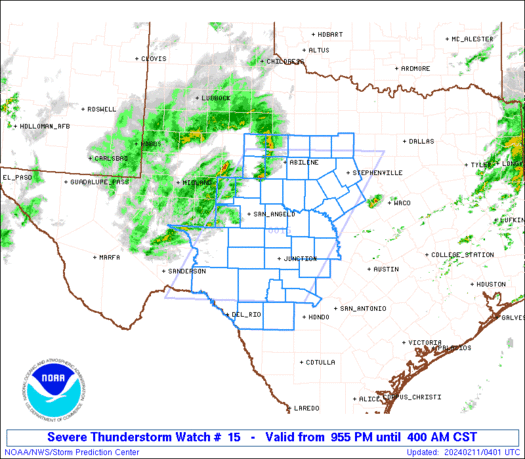
STATUS REPORT ON WW 15

SEVERE WEATHER THREAT CONTINUES RIGHT OF A LINE FROM 25 NW PRX TO
10 SE ADM TO 15 NNE PNC.

..SPC..03/07/26

ATTN...WFO...TSA...OUN...SHV...FWD...


STATUS REPORT FOR WT 15

SEVERE WEATHER THREAT CONTINUES FOR THE FOLLOWING AREAS

OKC001-005-013-021-023-029-035-037-041-061-063-069-077-079-091-
097-101-105-107-111-113-115-117-121-123-125-127-131-133-135-143-
145-147-070340-

OK
.    OKLAHOMA COUNTIES INCLUDED ARE

ADAIR                ATOKA               BRYAN
CHEROKEE             CHOCTAW             COAL
CRAIG                CREEK               DELAWARE
HASKELL              HUGHES              JOHNSTON
LATIMER              LE FLORE            MCINTOSH
MAYES                MUSKOGEE            NOWATA
OKFUSKEE             OKMULGEE            OSAGE
OTTAWA               PAWNEE              PITTSBURG
PONTOTOC             POTTAWATOMIE        PUSHMATAHA
ROGERS               SEMINOLE            SEQUOYAH
TULSA                WAGONER             WASHINGTON


THE WATCH STATUS MESSAGE IS FOR GUIDANCE PURPOSES ONLY.  PLEASE
REFER TO WATCH COUNTY NOTIFICATION STATEMENTS FOR OFFICIAL
INFORMATION ON COUNTIES...INDEPENDENT CITIES AND MARINE ZONES
CLEARED FROM SEVERE THUNDERSTORM AND TORNADO WATCHES.
Read morehttps://www.spc.noaa.gov/products/watch/ws0015.html
0
8
Read More
|
SPC Tornado Watch 15
Webmaster
4 hours ago
SPC Tornado Watch 15WW 15 TORNADO OK TX 062045Z - 070400Z
URGENT - IMMEDIATE BROADCAST REQUESTED
Tornado Watch Number 15
NWS Storm Prediction Center Norman OK
245 PM CST Fri Mar 6 2026

The NWS Storm Prediction Center has issued a

* Tornado Watch for portions of
  Central and Eastern Oklahoma
  North Texas

* Effective this Friday afternoon and evening from 245 PM until
  1000 PM CST.

* Primary threats include...
  A few tornadoes and a couple intense tornadoes possible
  Scattered large hail likely with isolated very large hail events
    to 2.5 inches in diameter possible
  Scattered damaging wind gusts to 70 mph possible

SUMMARY...Severe thunderstorms including supercells are expected to
develop through mid/late afternoon across the region, with the most
intense storms capable of large hail, damaging winds, and a tornado
risk.

The tornado watch area is approximately along and 80 statute miles
east and west of a line from 15 miles northeast of Bartlesville OK
to 25 miles southeast of Mineral Wells TX. For a complete depiction
of the watch see the associated watch outline update (WOUS64 KWNS
WOU5).

PRECAUTIONARY/PREPAREDNESS ACTIONS...

REMEMBER...A Tornado Watch means conditions are favorable for
tornadoes and severe thunderstorms in and close to the watch
area. Persons in these areas should be on the lookout for
threatening weather conditions and listen for later statements
and possible warnings.

&&

AVIATION...Tornadoes and a few severe thunderstorms with hail
surface and aloft to 2.5 inches. Extreme turbulence and surface wind
gusts to 60 knots. A few cumulonimbi with maximum tops to 450. Mean
storm motion vector 23025.

...Guyer
Read morehttps://www.spc.noaa.gov/products/watch/ww0015.html
0
8
Read More
|
SPC Tornado Watch 18 Status Reports
Webmaster
4 hours ago
SPC Tornado Watch 18 Status ReportsWW 0018 Status Updates 
STATUS REPORT ON WW 18

THE SEVERE WEATHER THREAT CONTINUES ACROSS THE ENTIRE WATCH AREA.

..SPC..03/07/26

ATTN...WFO...ICT...SGF...EAX...


STATUS REPORT FOR WT 18

SEVERE WEATHER THREAT CONTINUES FOR THE FOLLOWING AREAS

KSC001-011-019-021-037-049-099-125-133-205-207-070340-

KS
.    KANSAS COUNTIES INCLUDED ARE

ALLEN                BOURBON             CHAUTAUQUA
CHEROKEE             CRAWFORD            ELK
LABETTE              MONTGOMERY          NEOSHO
WILSON               WOODSON


MOC009-011-013-015-029-039-043-057-059-077-083-085-097-105-109-
119-131-141-145-167-185-209-217-225-070340-

MO
.    MISSOURI COUNTIES INCLUDED ARE

BARRY                BARTON              BATES
BENTON               CAMDEN              CEDAR
CHRISTIAN            DADE                DALLAS
GREENE               HENRY               HICKORY
JASPER               LACLEDE             LAWRENCE
MCDONALD             MILLER              MORGAN
NEWTON               POLK                ST. CLAIR
STONE                VERNON              WEBSTER
Read morehttps://www.spc.noaa.gov/products/watch/ws0018.html
0
8
Read More
|
SPC Tornado Watch 18
Webmaster
4 hours ago
SPC Tornado Watch 18WW 18 TORNADO KS MO 062345Z - 070700Z
URGENT - IMMEDIATE BROADCAST REQUESTED
Tornado Watch Number 18
NWS Storm Prediction Center Norman OK
545 PM CST Fri Mar 6 2026

The NWS Storm Prediction Center has issued a

* Tornado Watch for portions of
  Southeast Kansas
  Southwest Missouri

* Effective this Friday afternoon and Saturday morning from 545
  PM until 100 AM CST.

* Primary threats include...
  A few tornadoes likely with a couple intense tornadoes possible
  Scattered large hail and isolated very large hail events to 2
    inches in diameter likely
  Scattered damaging wind gusts to 70 mph likely

SUMMARY...A cluster of supercell thunderstorms over northeast
Oklahoma will build northeastward into the watch through the
evening.  The strongest cells will pose a risk of a few tornadoes,
damaging wind gusts, and hail.

The tornado watch area is approximately along and 90 statute miles
east and west of a line from 40 miles south southwest of Joplin MO
to 90 miles north northwest of Springfield MO. For a complete
depiction of the watch see the associated watch outline update
(WOUS64 KWNS WOU8).

PRECAUTIONARY/PREPAREDNESS ACTIONS...

REMEMBER...A Tornado Watch means conditions are favorable for
tornadoes and severe thunderstorms in and close to the watch
area. Persons in these areas should be on the lookout for
threatening weather conditions and listen for later statements
and possible warnings.

&&

OTHER WATCH INFORMATION...CONTINUE...WW 15...WW 16...WW 17...

AVIATION...Tornadoes and a few severe thunderstorms with hail
surface and aloft to 2 inches. Extreme turbulence and surface wind
gusts to 60 knots. A few cumulonimbi with maximum tops to 500. Mean
storm motion vector 24035.

...Hart
Read morehttps://www.spc.noaa.gov/products/watch/ww0018.html
0
8
Read More
|
SPC Severe Thunderstorm Watch 17 Status Reports
Webmaster
4 hours ago
SPC Severe Thunderstorm Watch 17 Status ReportsWW 0017 Status Updates 
STATUS REPORT ON WW 17

SEVERE WEATHER THREAT CONTINUES RIGHT OF A LINE FROM 10 W LAF TO
25 E SBN TO 20 SW LAN.

..MOORE..03/07/26

ATTN...WFO...LOT...IWX...GRR...


STATUS REPORT FOR WS 17

SEVERE WEATHER THREAT CONTINUES FOR THE FOLLOWING AREAS

INC017-039-049-085-087-103-113-151-169-183-070340-

IN
.    INDIANA COUNTIES INCLUDED ARE

CASS                 ELKHART             FULTON
KOSCIUSKO            LAGRANGE            MIAMI
NOBLE                STEUBEN             WABASH
WHITLEY


MIC023-059-070340-

MI
.    MICHIGAN COUNTIES INCLUDED ARE

BRANCH               HILLSDALE


THE WATCH STATUS MESSAGE IS FOR GUIDANCE PURPOSES ONLY.  PLEASE
REFER TO WATCH COUNTY NOTIFICATION STATEMENTS FOR OFFICIAL
INFORMATION ON COUNTIES...INDEPENDENT CITIES AND MARINE ZONES
CLEARED FROM SEVERE THUNDERSTORM AND TORNADO WATCHES.
Read morehttps://www.spc.noaa.gov/products/watch/ws0017.html
0
5
Read More
|
SPC Severe Thunderstorm Watch 17
Webmaster
4 hours ago
SPC Severe Thunderstorm Watch 17WW 17 SEVERE TSTM IL IN MI LM 062300Z - 070400Z
URGENT - IMMEDIATE BROADCAST REQUESTED
Severe Thunderstorm Watch Number 17
NWS Storm Prediction Center Norman OK
600 PM EST Fri Mar 6 2026

The NWS Storm Prediction Center has issued a

* Severe Thunderstorm Watch for portions of
  Northeast Illinois
  Northern Indiana
  Southwest Lower Michigan
  Lake Michigan

* Effective this Friday evening from 600 PM until 1100 PM EST.

* Primary threats include...
  Scattered damaging wind gusts to 70 mph possible
  Isolated large hail events to 1.5 inches in diameter possible
  A tornado or two possible

SUMMARY...A line of thunderstorms over southern Lake Michigan and
central Illinois will track eastward through the evening, posing a
risk of locally damaging wind gusts and hail.

The severe thunderstorm watch area is approximately along and 60
statute miles east and west of a line from 30 miles northeast of
South Bend IN to 70 miles south southwest of Valparaiso IN. For a
complete depiction of the watch see the associated watch outline
update (WOUS64 KWNS WOU7).

PRECAUTIONARY/PREPAREDNESS ACTIONS...

REMEMBER...A Severe Thunderstorm Watch means conditions are
favorable for severe thunderstorms in and close to the watch area.
Persons in these areas should be on the lookout for threatening
weather conditions and listen for later statements and possible
warnings. Severe thunderstorms can and occasionally do produce
tornadoes.

&&

OTHER WATCH INFORMATION...CONTINUE...WW 15...WW 16...

AVIATION...A few severe thunderstorms with hail surface and aloft to
1.5 inches. Extreme turbulence and surface wind gusts to 60 knots. A
few cumulonimbi with maximum tops to 500. Mean storm motion vector
24030.

...Hart
Read morehttps://www.spc.noaa.gov/products/watch/ww0017.html
0
5
Read More
|
SPC Tornado Watch 16 Status Reports
Webmaster
4 hours ago
SPC Tornado Watch 16 Status ReportsWW 0016 Status Updates 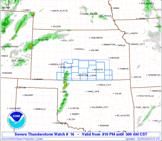
STATUS REPORT ON WW 16

SEVERE WEATHER THREAT CONTINUES RIGHT OF A LINE FROM 20 SSE HUT
TO 35 WNW BIE TO 20 NE DNS TO 35 SW ALO.

..MOORE..03/07/26

ATTN...WFO...DMX...OAX...EAX...ICT...TOP...GID...DDC...


STATUS REPORT FOR WT 16

SEVERE WEATHER THREAT CONTINUES FOR THE FOLLOWING AREAS

IAC001-003-009-015-027-029-039-049-053-071-073-077-121-129-137-
145-153-155-159-165-169-173-175-181-070340-

IA
.    IOWA COUNTIES INCLUDED ARE

ADAIR                ADAMS               AUDUBON
BOONE                CARROLL             CASS
CLARKE               DALLAS              DECATUR
FREMONT              GREENE              GUTHRIE
MADISON              MILLS               MONTGOMERY
PAGE                 POLK                POTTAWATTAMIE
RINGGOLD             SHELBY              STORY
TAYLOR               UNION               WARREN


KSC005-013-017-027-041-043-045-061-085-087-111-115-117-127-131-
139-149-161-177-197-070340-

KS
.    KANSAS COUNTIES INCLUDED ARE

ATCHISON             BROWN               CHASE
CLAY                 DICKINSON           DONIPHAN
DOUGLAS              GEARY               JACKSON
Read morehttps://www.spc.noaa.gov/products/watch/ws0016.html
0
5
Read More
|
SPC Tornado Watch 16
Webmaster
4 hours ago
SPC Tornado Watch 16WW 16 TORNADO IA KS MO NE 062115Z - 070400Z
URGENT - IMMEDIATE BROADCAST REQUESTED
Tornado Watch Number 16
NWS Storm Prediction Center Norman OK
315 PM CST Fri Mar 6 2026

The NWS Storm Prediction Center has issued a

* Tornado Watch for portions of
  Western and Central Iowa
  Central and Northeast Kansas
  Northwest Missouri
  Southeast Nebraska

* Effective this Friday afternoon and evening from 315 PM until
  1000 PM CST.

* Primary threats include...
  A few tornadoes and a couple intense tornadoes possible
  Scattered large hail likely with isolated very large hail events
    to 2 inches in diameter possible
  Scattered damaging wind gusts to 70 mph possible

SUMMARY...Severe storms are expected to develop near a
northeast/southwest-oriented cold front, with additional development
possible into this evening ahead of it. All aspects of severe
weather are possible including large hail, damaging winds, and
tornado potential.

The tornado watch area is approximately along and 65 statute miles
north and south of a line from 35 miles south southwest of Russell
KS to 50 miles south southeast of Fort Dodge IA. For a complete
depiction of the watch see the associated watch outline update
(WOUS64 KWNS WOU6).

PRECAUTIONARY/PREPAREDNESS ACTIONS...

REMEMBER...A Tornado Watch means conditions are favorable for
tornadoes and severe thunderstorms in and close to the watch
area. Persons in these areas should be on the lookout for
threatening weather conditions and listen for later statements
and possible warnings.

&&

OTHER WATCH INFORMATION...CONTINUE...WW 15...

AVIATION...Tornadoes and a few severe thunderstorms with hail
surface and aloft to 2 inches. Extreme turbulence and surface wind
gusts to 60 knots. A few cumulonimbi with maximum tops to 450. Mean
storm motion vector 23030.

...Guyer
Read morehttps://www.spc.noaa.gov/products/watch/ww0016.html
0
3
Read More
|
SPC MD 151
Webmaster
4 hours ago
SPC MD 151MD 0151 CONCERNING HEAVY SNOW FOR NORTHEAST COLORADO INTO WESTERN NEBRASKA 
Mesoscale Discussion 0151
NWS Storm Prediction Center Norman OK
0436 PM CST Fri Mar 06 2026

Areas affected...Northeast Colorado into western Nebraska

Concerning...Heavy snow

Valid 062236Z - 070230Z

SUMMARY...Moderate to heavy snow bands will likely continue into the
early evening hours across northeast Colorado into parts of western
Nebraska. Snowfall rates may exceed 1 inch/hour under the more
persistent bands.

DISCUSSION...Transient snow bands have been evident in regional
radar mosaics over the past couple of hours across northeast CO  and
western NE. ASOS/AWOS observations under these bands have been
reporting visibility reductions down to 1/4 mile at times under the
heavier bands. Despite winds of 20-25 mph, blowing snow model output
suggests these visibility reductions are mainly attributable to
heavy snowfall rates given temperatures in the upper 20s/low 30s.

Heading into the evening hours, strong synoptic ascent within the
left-exit region of a passing upper jet coupled with more focused
frontogenetical lift between 850-700 mb will support a continuation
of at least transient heavy snow bands across northeast CO and into
parts of western NE for the next several hours. Although some areas
remain above freezing, an influx of colder air behind a passing cold
front should allow for temperatures through the lowest couple of
kilometers to fall below freezing and support moderate to heavy
snowfall rates later this evening. Based on recent observations and
latest model guidance, snowfall rates up to one inch/hour appear
likely under the heavier, more persistent snow bands.

..Moore.. 03/06/2026

...Please see www.spc.noaa.gov for graphic product...

ATTN...WFO...LBF...GLD...BOU...CYS...

LAT...LON   42530228 42560160 42410125 42110098 41800093 41460099
            41230127 40930167 40650203 40030254 39520307 39180360
            39130393 39220427 39430456 39770464 40110455 40630436
            41130395 42210277 42530228
Read morehttps://www.spc.noaa.gov/products/md/md0151.html
0
4
Read More
|
|
Forums60
Topics764,724
Posts799,472
Members2,958
| |
Most Online17,963
Jan 15th, 2026
|
|
|
|
|
Copyright 1996 - 2026 by David Cottle. Designed by David Bate Jr. All Rights Reserved.
By using this forum, the user agrees not to transfer any data or technical information received under the agreement, to any other entity without the express approval of the AUS-CITY Forum Admins and/or authors of individual posts (Forum Admins and DoD/USSPACECOM for the analysis of satellite tracking data).
Two-line elements (TLE) and all other satellite data presented and distributed via this forum and e-mail lists of AUS-CITY are distributed with permission from DoD/USSTRATCOM.


Reprise Hosting

|

|


 - Click image for larger picture.")


