|
|
|
0 members (),
1,528
guests, and
25
robots. |
|
Key:
Admin,
Global Mod,
Mod
|
|
S |
M |
T |
W |
T |
F |
S |
|
|
|
|
1
|
2
|
3
|
4
|
|
5
|
6
|
7
|
8
|
9
|
10
|
11
|
|
12
|
13
|
14
|
15
|
16
|
17
|
18
|
|
19
|
20
|
21
|
22
|
23
|
24
|
25
|
|
26
|
27
|
28
|
29
|
30
|
|
|
|
There are no members with birthdays on this day. |
 World Earthquake Report for Sunday, 12 April 2026
Webmaster
5 hours ago
World Earthquake Report for Sunday, 12 April 2026
Webmaster
5 hours ago
World Earthquake Report for Sunday, 12 April 2026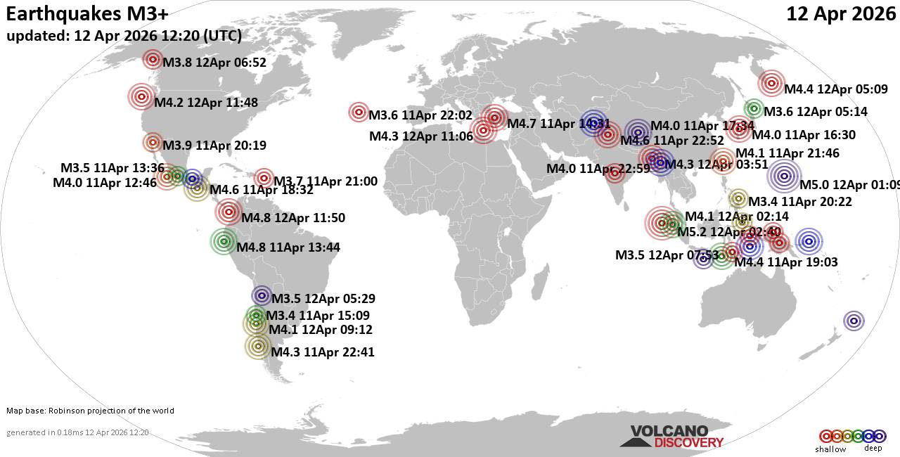 Worldwide earthquakes above magnitude 3 during the past 24 hours on 12 Apr 2026 Magnitude 5+: 2 earthquakes Magnitude 4+: 31 earthquakes Magnitude 3+: 157 earthquakes Magnitude 2+: 415 earthquakes No quakes of magnitude 6 or higher 10 largest earthquakes in the world (past 24 hours)Sunday, Apr 12, 2026, at 08:40 am (GMT +6) - Sunday, Apr 12, 2026, at 11:09 am (GMT +10) - Sunday, Apr 12, 2026, at 06:50 am (GMT -5) - Saturday, Apr 11, 2026, at 08:44 am (GMT -5) - Saturday, Apr 11, 2026, at 05:31 pm (GMT +3) - Saturday, Apr 11, 2026, at 12:32 pm (GMT -6) - Sunday, Apr 12, 2026, at 04:22 am (GMT +5:30) - Sunday, Apr 12, 2026, at 05:21 am (GMT +8) - Sunday, Apr 12, 2026, at 04:29 am (GMT +4:30) - Sunday, Apr 12, 2026, at 05:09 pm (Kamchatka time) - Earthquakes reported feltSunday, Apr 12, 2026, at 09:21 am (GMT +5:30) - Saturday, Apr 11, 2026, at 05:31 pm (GMT +3) - Saturday, Apr 11, 2026, at 06:41 pm (GMT -4) - Saturday, Apr 11, 2026, at 09:53 pm (GMT -6) - Sunday, Apr 12, 2026, at 04:22 am (GMT +5:30) - Sunday, Apr 12, 2026, at 04:37 am (Kolkata time) - Sunday, Apr 12, 2026, at 04:00 am (GMT -4) - Saturday, Apr 11, 2026, at 10:01 pm (GMT -6) - Sunday, Apr 12, 2026, at 09:34 am (GMT +3) - Sunday, Apr 12, 2026, at 08:40 am (GMT +6) - Saturday, Apr 11, 2026, at 12:32 pm (GMT -6) - Sunday, Apr 12, 2026, at 03:03 am (GMT +8) - Saturday, Apr 11, 2026, at 08:44 am (GMT -5) - Saturday, Apr 11, 2026, at 05:00 pm (GMT -4) - Sunday, Apr 12, 2026, at 12:51 am (Kolkata time) - Saturday, Apr 11, 2026, at 11:12 am (GMT -7) - Sunday, Apr 12, 2026, at 04:12 am (GMT -7) - Saturday, Apr 11, 2026, at 07:11 pm (GMT +3) - Sunday, Apr 12, 2026, at 05:12 am (GMT -4) - Saturday, Apr 11, 2026, at 05:42 pm (GMT +3) - Earthquake stats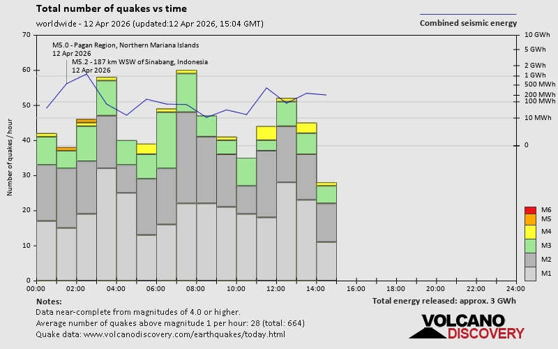 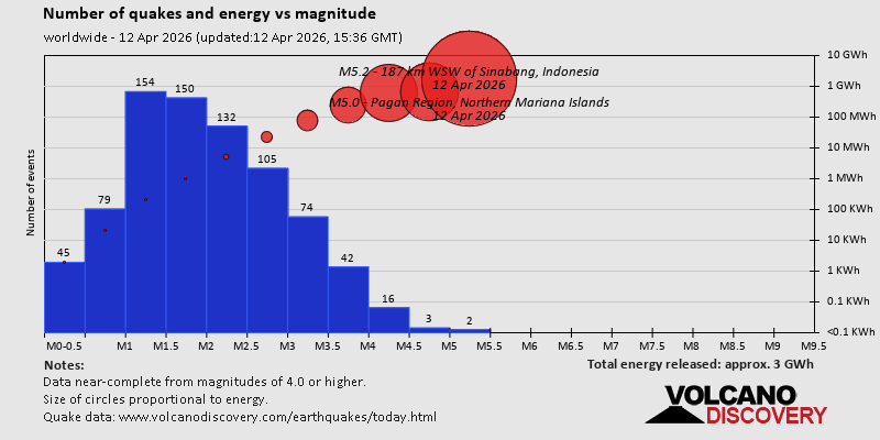 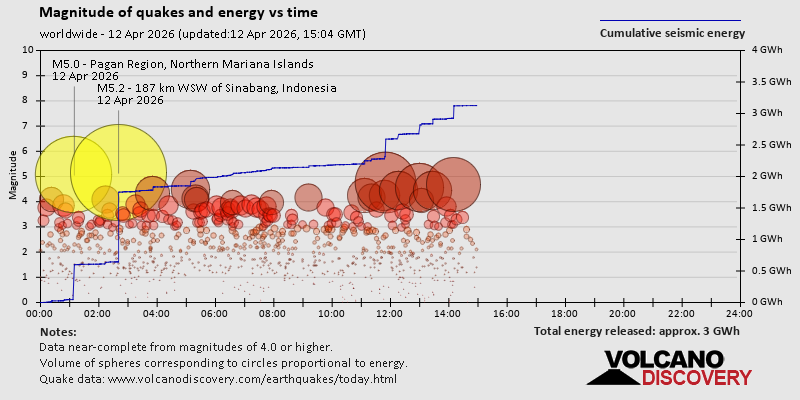 https://www.volcanodiscovery.com/earthquake/news/299788/World-Earthquake-Report-for-Sunday-12-April-2026.html https://www.volcanodiscovery.com/earthquake/news/299788/World-Earthquake-Report-for-Sunday-12-April-2026.html
0
18
Read More
|
Volcano earthquake report for Sunday, 12 Apr 2026
Webmaster
6 hours ago
Volcano earthquake report for Sunday, 12 Apr 2026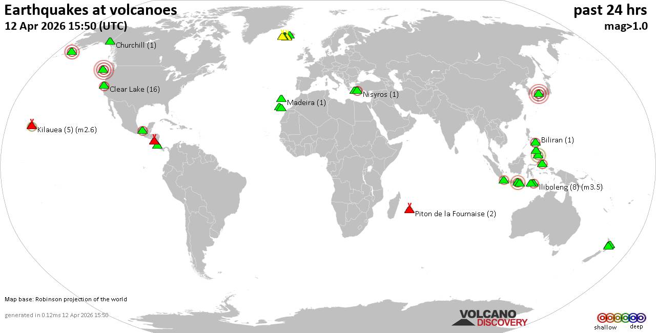 World map showing volcanoes with shallow (less than 50 km) earthquakes within 20 km radius during the past 24 hours on 12 Apr 2026 Number in brackets indicate nr of quakes. Quakes detected near: Baluran (2 quakes between mag 2.8-3.2), Bardarbunga (4 quakes between mag 1.1-1.6), Barva (4 quakes between mag 1.8-2.7), Biliran (1 quake mag 2.5), Brennisteinsfjöll (3 quakes between mag 0.2-1.1), Churchill (1 quake mag 1.0)
Clear Lake (17 quakes between mag 0.4-2.3), Cobb Segment (5 quakes between mag 2.9-3.7), El Chichón (2 quakes between mag 2.3-2.4), Etna (1 quake mag 1.1), Eyafjallajökull (1 quake mag 1.5), Gagak (1 quake mag 2.1), Grímsnes (14 quakes between mag 0.0-1.6), Hekla (1 quake mag 1.0), Iliboleng (8 quakes between mag 2.1-3.5), Jailolo (2 quakes between mag 2.1-2.2), Katla (10 quakes between mag 0.0-1.4), Kilauea (5 quakes between mag 1.7-2.6), Kolumbo (1 quake mag 1.2), La Palma (1 quake mag 1.8), Latukan (2 quakes between mag 1.6-2.2), Madeira (1 quake mag 1.4), Mammoth Mountain (1 quake mag 1.3), Maroa (5 quakes between mag 1.6-2.4), Masaya (6 quakes between mag 1.1-3.1), Nisyros (1 quake mag 2.0), Okataina (Tarawera) (1 quake mag 2.5), Piton de la Fournaise (3 quakes between mag 0.3-1.5), Sanbe (1 quake mag 4.0), Svartsengi (1 quake mag 1.0), Tenerife (11 quakes between mag 1.0-2.0), Tjörnes Fracture Zone (3 quakes between mag 0.6-1.4), Torfajökull (3 quakes between mag 0.9-1.0) (updated 11h50)
Note: Earthquakes within 20 km from and at depths less than 50 km under active volcanoes are reported. The list is not complete because many volcanoes are not monitored and/or seismic data in high resolution is not available publicly.
Volcanoes with recent earthquakes above magnitude 2 or more than 10 quakes are listed below:
Baluran volcano (East Java): 2 earthquakes up to magnitude 3.22 earthquakes occurred near (under) the volcano during 1 hour 22 minutes, the last being recorded quake 10 hours ago. Hypocenter depths ranged between 25.00 and 17.00 km. Earthquake details: 3.2 quake Kabupaten Situbondo, 19 km north of Wongsorejo, Indonesia, Apr 12, 2026 09:04 am (GMT +7) (6 km NE) 2.8 quake Kabupaten Situbondo, 17 km north of Wongsorejo, Indonesia, Apr 12, 2026 07:43 am (GMT +7) (1 km N) All earthquakes at BaluranBarva volcano (Costa Rica): 4 earthquakes up to magnitude 2.74 earthquakes occurred near (under) the volcano during 14 hours, the last being recorded quake 4 hours ago. Hypocenter depths ranged between 13.00 and 0.00 km. Earthquake details: 2.7 quake Provincia de Heredia, 27 km northeast of San Jose, Costa Rica, Apr 12, 2026 01:42 am (GMT -6) (14 km ENE) 2.4 quake Provincia de Heredia, 27 km northeast of San Jose, Costa Rica, Apr 11, 2026 11:42 am (Costa_Rica time) (13 km E) 1.8 quake Provincia de Heredia, 27 km north of San Jose, Provincia de San Jose, Costa Rica, Apr 12, 2026 01:43 am (Costa_Rica time) (12 km E) 1.8 quake 28 km northeast of San Jose, Provincia de San Jose, Costa Rica, Apr 11, 2026 12:18 pm (Costa_Rica time) (14 km E) All earthquakes at BarvaBiliran volcano (Central Philippines): magnitude 2.5 earthquakeA magnitude 2.5 earthquake occurred at the volcano 9 hours ago. The quake, which might be volcanic in origin, was located at a depth of 26.00 km depth at 8 km distance W from the volcano. Earthquake details: 2.5 quake 8.2 km southeast of Naval, Biliran, Eastern Visayas, Philippines, Apr 12, 2026 11:12 am (GMT +8) (8 km W) All earthquakes at BiliranClear Lake volcano (California): 17 earthquakes up to magnitude 2.3Possible earthquake swarm: 17 earthquakes occurred near (under) the volcano during 21 hours, the last being recorded quake 1 hour 12 minutes ago. Hypocenter depths ranged between 3.82 and 0.33 km. Earthquake details: (only 5 largest) 2.3 quake 12 mi southwest of Clearlake, Lake County, California, United States, Apr 12, 2026 02:25 am (GMT -7) (15 km S) 1.6 quake Sonoma County, 13 mi southwest of Clearlake, Lake County, California, United States, Apr 11, 2026 11:53 am (GMT -7) (19 km S) 1.3 quake 25 mi north of Santa Rosa, Sonoma County, California, United States, Apr 11, 2026 04:10 pm (GMT -7) (19 km S) 1.2 quake 27 mi north of Santa Rosa, Sonoma County, California, United States, Apr 11, 2026 07:01 am (GMT -7) (18 km SSW) 1.2 quake 27 mi north of Santa Rosa, Sonoma County, California, United States, Apr 11, 2026 11:28 pm (GMT -7) (17 km SSW) All earthquakes at Clear LakeCobb Segment volcano (Northern Pacific Ocean): 5 earthquakes up to magnitude 3.75 earthquakes occurred near (under) the volcano during 1 hour 17 minutes, the last being recorded quake 2 hours ago. Hypocenter depths ranged between 10.00 and 10.00 km. Earthquake details: 3.7 quake North Pacific Ocean, 364 km southwest of Tofino, Regional District of Alberni-Clayoquot, British Columbia, Canada, Apr 12, 2026 12:47 am (GMT -9) (6 km SSW) 3.0 quake Off the Coast of Washington Apr 11, 2026 11:59 pm (GMT -9) (19 km WSW) 3.0 quake Off the Coast of Washington Apr 11, 2026 11:30 pm (GMT -9) (4 km NE) 2.9 quake Off the Coast of Washington Apr 12, 2026 12:07 am (GMT -9) (16 km E) 2.9 quake Off the Coast of Washington Apr 11, 2026 11:49 pm (GMT -9) (11 km E) All earthquakes at Cobb SegmentEl Chichón volcano (Southern Mexico): 2 earthquakes up to magnitude 2.42 earthquakes occurred near (under) the volcano during 6 hours, the last being recorded quake 15 hours ago. Hypocenter depths ranged between 9.00 and 2.80 km. Earthquake details: 2.4 quake Estado de Chiapas, 37 km southwest of Teapa, Estado de Tabasco, Mexico, Apr 11, 2026 02:37 pm (GMT -6) (1 km NW) 2.3 quake Estado de Chiapas, 33 km southwest of Teapa, Estado de Tabasco, Mexico, Apr 11, 2026 08:17 am (GMT -6) (4 km NNE) All earthquakes at El ChichónGagak volcano (West Java): magnitude 2.1 earthquakeA magnitude 2.1 earthquake occurred at the volcano 8 hours ago. The quake, which might be volcanic in origin, was located at a depth of 23.00 km depth at 4 km distance NE from the volcano. Earthquake details: 2.1 quake Bogor Regency, 15 km northwest of Cicurug, Indonesia, Apr 12, 2026 10:47 am (GMT +7) (4 km NE) All earthquakes at GagakGrímsnes volcano (Iceland): 14 earthquakes up to magnitude 1.6Possible earthquake swarm: 14 earthquakes occurred near (under) the volcano during 1 hour 4 minutes, the last being recorded quake 28 minutes ago. Hypocenter depths ranged between 5.10 and 0.00 km. Earthquake details: (only 5 largest) 1.6 quake 6.6 km NW of Þjórsárbrú Apr 12, 2026 10:41 am (Universal Time) (9 km SE) 1.6 quake Iceland: 6.5 km NW of Þjórsárbrú Apr 12, 2026 10:45 am (Reykjavik time) (9 km SE) 1.4 quake Iceland: 5.4 km WNW of Þjórsárbrú Apr 12, 2026 10:35 am (Reykjavik time) (10 km SE) 1.3 quake Iceland: 7.0 km WNW of Þjórsárbrú Apr 12, 2026 10:17 am (Reykjavik time) (9 km SSE) 1.2 quake 6.7 km NW of Þjórsárbrú Apr 12, 2026 10:47 am (Universal Time) (9 km SE) All earthquakes at GrímsnesIliboleng volcano (Lesser Sunda Islands): 8 earthquakes up to magnitude 3.58 earthquakes occurred near (under) the volcano during 22 hours, the last being recorded quake 45 minutes ago. Hypocenter depths ranged between 7.00 and 3.00 km. Earthquake details: (only 5 largest) 3.5 quake Kabupaten Flores Timur, 33 km west of Lewoleba, Indonesia, Apr 12, 2026 03:53 pm (GMT +8) (15 km W) 2.9 quake Kabupaten Flores Timur, 32 km west of Lewoleba, Indonesia, Apr 11, 2026 08:42 pm (GMT +8) (17 km SW) 2.8 quake Kabupaten Flores Timur, 27 km west of Lewoleba, Indonesia, Apr 12, 2026 03:10 pm (GMT +8) (11 km WSW) 2.4 quake Kabupaten Flores Timur, 32 km west of Lewoleba, Indonesia, Apr 12, 2026 11:00 am (GMT +8) (17 km SW) 2.4 quake Savu Sea, 16 km south of Pulau Adonara Island, East Nusa Tenggara, Indonesia, Apr 12, 2026 05:10 am (GMT +8) (16 km SSW) All earthquakes at IlibolengJailolo volcano (Halmahera): 2 earthquakes up to magnitude 2.22 earthquakes occurred near (under) the volcano during 4 hours, the last being recorded quake 12 hours ago. Hypocenter depths ranged between 9.00 and 6.00 km. Earthquake details: 2.2 quake Kabupaten Halmahera Barat, 34 km north of Ternate, Indonesia, Apr 12, 2026 05:22 am (GMT +9) (9 km E) 2.1 quake Kabupaten Halmahera Barat, 40 km north of Ternate, Indonesia, Apr 12, 2026 09:00 am (GMT +9) (9 km NE) All earthquakes at JailoloKilauea volcano (Hawai'i (Big Island)): 5 earthquakes up to magnitude 2.65 earthquakes occurred near (under) the volcano during 5 hours, the last being recorded quake 14 hours ago. Hypocenter depths ranged between 29.17 and 5.90 km. Earthquake details: 2.6 quake 35 mi southwest of Hilo, Hawaii County, Hawaii, United States, Apr 11, 2026 11:49 am (GMT -10) (16 km SW) 2.6 quake 36 mi southwest of Hilo, Hawaii County, Hawaii, United States, Apr 11, 2026 11:49 am (GMT -10) (18 km SW) 1.7 quake 36 mi southwest of Hilo, Hawaii County, Hawaii, United States, Apr 11, 2026 08:35 am (GMT -10) (17 km SW) 1.7 quake 36 mi southwest of Hilo, Hawaii County, Hawaii, United States, Apr 11, 2026 08:03 am (GMT -10) (17 km SW) 1.7 quake 28 mi southwest of Hilo, Hawaii County, Hawaii, United States, Apr 11, 2026 06:43 am (GMT -10) (18 km WNW) All earthquakes at KilaueaLatukan volcano (Mindanao): 2 earthquakes up to magnitude 2.22 earthquakes occurred near (under) the volcano during 7 minutes, the last being recorded quake 18 hours ago. Hypocenter depths ranged between 8.00 and 8.00 km. Earthquake details: 2.2 quake 44 km north of Midsayap, Cotabato, Soccsksargen, Philippines, Apr 12, 2026 01:44 am (GMT +8) (8 km SSE) 1.6 quake 41 km north of Midsayap, Cotabato, Soccsksargen, Philippines, Apr 12, 2026 01:51 am (GMT +8) (11 km SSE) All earthquakes at LatukanMaroa volcano (New Zealand): 5 earthquakes up to magnitude 2.45 earthquakes occurred near (under) the volcano during 3 hours, the last being recorded quake 19 hours ago. Hypocenter depths ranged between 4.70 and 3.60 km. Earthquake details: 2.4 quake 18 km northeast of Taupo, Waikato, New Zealand, Apr 12, 2026 02:17 am (GMT +12) (16 km SE) 2.0 quake 19 km northeast of Taupo, Waikato, New Zealand, Apr 12, 2026 01:24 am (GMT +12) (15 km SE) 1.7 quake 19 km northeast of Taupo, Waikato, New Zealand, Apr 12, 2026 04:25 am (GMT +12) (17 km SE) 1.6 quake 18 km northeast of Taupo, Waikato, New Zealand, Apr 12, 2026 01:42 am (GMT +12) (16 km SE) 1.6 quake 18 km northeast of Taupo, Waikato, New Zealand, Apr 12, 2026 01:23 am (GMT +12) (17 km SE) All earthquakes at MaroaMasaya volcano (Nicaragua): 6 earthquakes up to magnitude 3.16 earthquakes occurred near (under) the volcano during 1 hour 5 minutes, the last being recorded quake 7 hours ago. Hypocenter depths ranged between 16.00 and 4.00 km. Earthquake details: (only 5 largest) 3.1 quake 2.6 km west of Masaya, Departamento de Masaya, Nicaragua, Apr 11, 2026 09:53 pm (GMT -6) (5 km ESE) 2.4 quake 10.6 km south of Masaya, Departamento de Masaya, Nicaragua, Apr 11, 2026 10:01 pm (GMT -6) (12 km SSE) 1.8 quake 3 km west of Masaya, Departamento de Masaya, Nicaragua, Apr 11, 2026 10:33 pm (GMT -6) (4 km E) 1.7 quake 4.5 km west of Masaya, Departamento de Masaya, Nicaragua, Apr 11, 2026 09:55 pm (GMT -6) (3 km SE) 1.4 quake 2.3 km west of Masaya, Departamento de Masaya, Nicaragua, Apr 11, 2026 10:02 pm (GMT -6) (5 km ESE) All earthquakes at MasayaOkataina (Tarawera) volcano (New Zealand): magnitude 2.5 earthquakeA magnitude 2.5 earthquake occurred at the volcano 9 hours ago. The quake, which might be volcanic in origin, was located at a depth of 5.00 km depth at 15 km distance ESE from the volcano. Earthquake details: 2.5 quake 36 km east of Rotorua, Bay of Plenty, New Zealand, Apr 12, 2026 02:38 pm (GMT +12) (15 km ESE) All earthquakes at Okataina (Tarawera)Sanbe volcano (Honshu): magnitude 4.0 earthquakeA magnitude 4.0 earthquake occurred at the volcano 19 hours ago. The quake, which might be volcanic in origin, was located at a depth of 10.00 km depth at 8 km distance ESE from the volcano. Earthquake details: 4.0 quake 30 km south of Izumo, Shimane, Japan, Apr 12, 2026 01:30 am (GMT +9) (8 km ESE) All earthquakes at SanbeTenerife volcano (Canary Islands): 11 earthquakes up to magnitude 2.0Possible earthquake swarm: 11 earthquakes occurred near (under) the volcano during 3 hours, the last being recorded quake 17 hours ago. Hypocenter depths ranged between 10.00 and 2.00 km. Earthquake details: (only 5 largest) 2.0 quake 8.4 km southeast of La Orotava, Santa Cruz de Tenerife, Canary Islands, Spain, Apr 11, 2026 07:55 pm (GMT +1) (18 km ENE) 1.6 quake 8.3 km southeast of La Orotava, Santa Cruz de Tenerife, Canary Islands, Spain, Apr 11, 2026 07:08 pm (GMT +1) (17 km ENE) 1.6 quake 7.9 km southeast of La Orotava, Santa Cruz de Tenerife, Canary Islands, Spain, Apr 11, 2026 06:41 pm (GMT +1) (17 km ENE) 1.6 quake 8.3 km southeast of La Orotava, Santa Cruz de Tenerife, Canary Islands, Spain, Apr 11, 2026 05:59 pm (GMT +1) (17 km ENE) 1.3 quake 7.6 km southeast of La Orotava, Santa Cruz de Tenerife, Canary Islands, Spain, Apr 11, 2026 07:57 pm (GMT +1) (19 km ENE) All earthquakes at Tenerifehttps://www.volcanodiscovery.com/earthquakes-volcanoes/news/299779/Volcano-earthquake-report-for-Sunday-12-Apr-2026.html
0
19
Read More
|
Moderate 4.3 quake hits near Silchar, Cachar, Assam, India
Webmaster
13 hours ago
Moderate 4.3 quake hits near Silchar, Cachar, Assam, India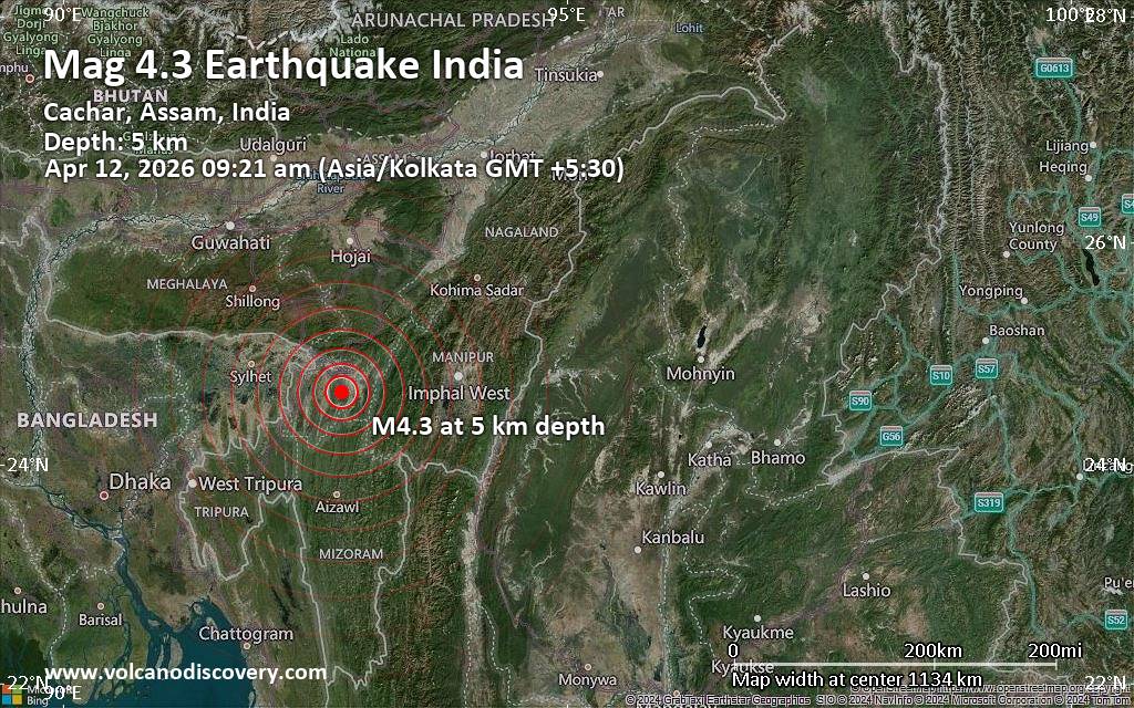 An earthquake of magnitude 4.3 occurred only 20 minutes ago 19 km south of Silchar, India, India's National Center for Seismology (NCS) reported.
The quake hit at a very shallow depth of 5. km beneath the epicenter near Silchar, Cachar, Assam, India, in the morning on Sunday, April 12th, 2026, at 8:51 am local time. The exact magnitude, epicenter, and depth of the quake might be revised within the next few hours or minutes as seismologists review data and refine their calculations, or as other agencies issue their report.
Based on the preliminary seismic data, the quake was probably felt by many people in the area of the epicenter. It should not have caused significant damage, other than objects falling from shelves, broken windows, etc.
In Irongmara (pop. 7,700) located 4 km from the epicenter, the quake should have been felt as light shaking.
Weak shaking might have been felt in Ambikapur Part-X (pop. 14,300) located 16 km from the epicenter, Ambicapur Pt VIII (pop. 11,700) 18 km away, Silchar (pop. 178,900) 19 km away, Hailakandi (pop. 33,600) 21 km away, Karimganj (pop. 56,900) 47 km away, and Kolasib (pop. 25,000) 49 km away.
Other towns or cities near the epicenter where the quake might have been felt as very weak shaking include Haflong (pop. 43,800) located 62 km from the epicenter, and Aizawl (pop. 293,400) 104 km away.
VolcanoDiscovery will automatically update magnitude and depth if these change and follow up if other significant news about the quake become available. If you’re in the area, please send us your experience through our reporting mechanism, either online or via our mobile app. This will help us provide more first-hand updates to anyone around the globe who wants to know more about this quake.
Earthquake data: Date & time: Apr 12, 2026 09:21 am (Kolkata time) local time (12 Apr 2026 03:51 GMT)Magnitude: 4.3 Depth: 5.00 km Epicenter latitude / longitude: 24.66°N / 92.76°E  ( Cachar, Assam, India) Primary data source: NCShttps://www.volcanodiscovery.com/earthquake/news/299786/Moderate-43-quake-hits-near-Silchar-Cachar-Assam-India.html
0
100
Read More
|
Seismic-like event, possible earthquake, reported few minutes ago near Managua, Managua Department, Nicaragua
Webmaster
14 hours ago
Seismic-like event, possible earthquake, reported few minutes ago near Managua, Managua Department, Nicaragua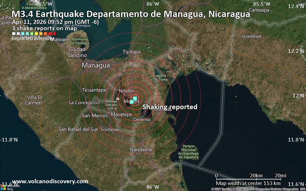 Unconfirmed quake or seismic-like event reported: 24 km southeast of Managua, Departamento de Managua, Nicaragua, 7 minutes ago We are receiving unverified early reports of ground shaking possibly caused by seismic activity in or near Managua, Managua Department, Nicaragua on 12 Apr 2026 (GMT) at approximately 03:52 GMT.
There are no details yet on the magnitude or depth of this possible quake. If confirmed, we can expect more accurate data to emerge in the next few minutes. The location, magnitude and time mentioned are indicative, based on our best-fit seismic model. They are temporary until our AllQuakes monitoring service receives more exact scientific data from a national or international seismological agency. Check back here shortly and stay safe.
Earthquake data: Date & time: Apr 11, 2026 09:52 pm (GMT -6) local time (12 Apr 2026 03:52 GMT)Magnitude: unspecified Depth: unspecified Epicenter latitude / longitude: 11.99°N / 86.08°W  ( Departamento de Managua, Nicaragua) Primary data source: VolcanoDiscoveryhttps://www.volcanodiscovery.com/earthquake/news/299784/Seismic-like-event-possible-earthquake-reported-few-minutes-ago-near-Managua-Managua-Department-Nica.html
0
8
Read More
|
Moderate yet deep magnitude 5.3 quake hits 35 km northwest of Pagan Village, Northern Mariana Islands in the morning
Webmaster
16 hours ago
Moderate yet deep magnitude 5.3 quake hits 35 km northwest of Pagan Village, Northern Mariana Islands in the morning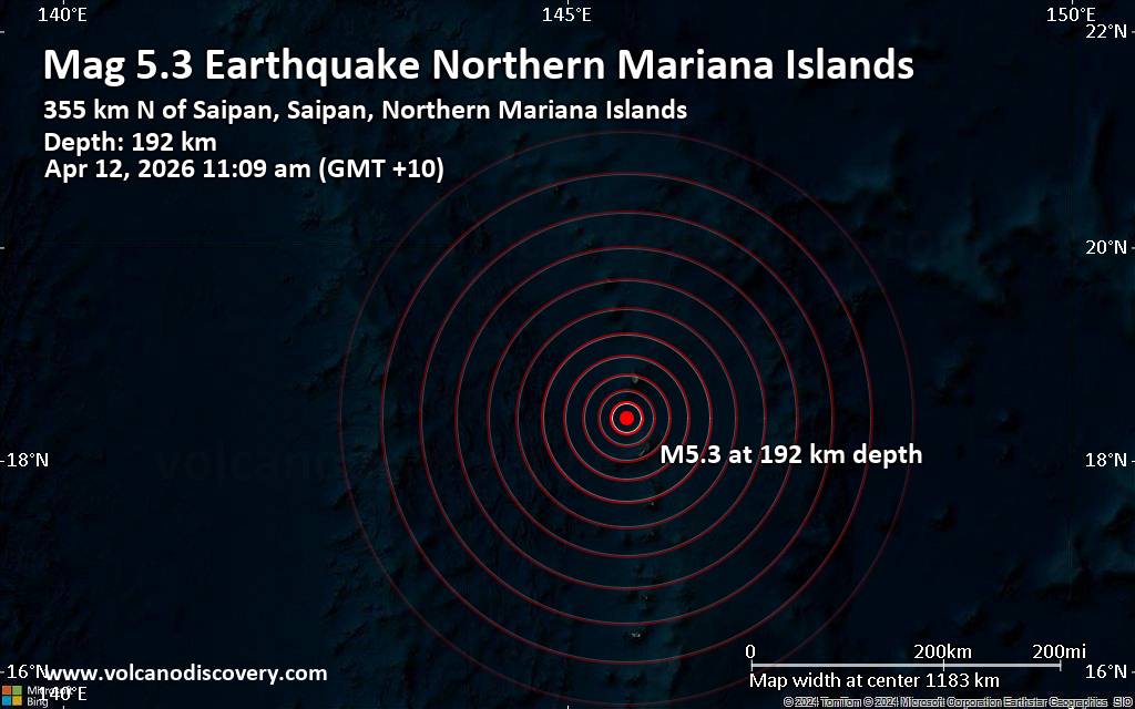 Just 11 minutes ago, a 5.3-magnitude earthquake struck near Pagan Village, Pagan Island, Northern Islands, Northern Mariana Islands. The tremor was recorded in the morning on Sunday, April 12th, 2026, at 11:09 am local time, at an intermediate to considerable depth of 192. km below the surface.
The event was filed by Indonesia's Meteorology, Climatology, and Geophysical Agency, the first seismological agency to report it.
Towns or cities near the epicenter where the quake might have been felt as very weak shaking include Pagan Village (pop. 50) located 35 km from the epicenter, and Agrihan Village (pop. 20) 38 km away.
VolcanoDiscovery will automatically update magnitude and depth if these change and follow up if other significant news about the quake become available. If you’re in the area, please send us your experience through our reporting mechanism, either online or via our mobile app. This will help us provide more first-hand updates to anyone around the globe who wants to know more about this quake.
Earthquake data: Date & time: Apr 12, 2026 11:09 am (GMT +10) local time (12 Apr 2026 01:09 GMT)Magnitude: 5.3 Depth: 192.00 km Epicenter latitude / longitude: 18.4°N / 145.59°E  (Northern Mariana Islands) Primary data source: BMKGhttps://www.volcanodiscovery.com/earthquake/news/299780/Moderate-yet-deep-magnitude-53-quake-hits-35-km-northwest-of-Pagan-Village-Northern-Mariana-Islands-.html
0
4
Read More
|
World Earthquake Report for Saturday, 11 April 2026
Webmaster
17 hours ago
World Earthquake Report for Saturday, 11 April 2026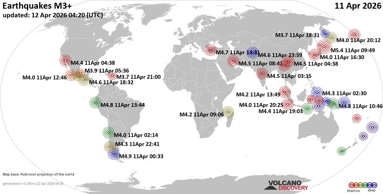 Worldwide earthquakes above magnitude 3 during the past 24 hours on 12 Apr 2026 Magnitude 5+: 1 earthquake Magnitude 4+: 47 earthquakes Magnitude 3+: 205 earthquakes Magnitude 2+: 410 earthquakes No quakes of magnitude 6 or higher 10 largest earthquakes in the world (11 Apr 2026)Saturday, Apr 11, 2026, at 07:49 pm (GMT +10) - Friday, Apr 10, 2026, at 08:33 pm (Coyhaique time) - Saturday, Apr 11, 2026, at 08:46 pm (GMT +10) - Saturday, Apr 11, 2026, at 08:44 am (GMT -5) - Saturday, Apr 11, 2026, at 05:31 pm (GMT +3) - Saturday, Apr 11, 2026, at 01:08 am (GMT -9) - Friday, Apr 10, 2026, at 03:39 pm (GMT -9) - Saturday, Apr 11, 2026, at 12:32 pm (GMT -6) - Sunday, Apr 12, 2026, at 04:29 am (GMT +4:30) - Sunday, Apr 12, 2026, at 04:22 am (GMT +5:30) - Earthquakes reported feltSaturday, Apr 11, 2026, at 08:45 am (GMT +5:30) - Saturday, Apr 11, 2026, at 05:31 pm (GMT +3) - Saturday, Apr 11, 2026, at 06:41 pm (GMT -4) - Sunday, Apr 12, 2026, at 04:22 am (GMT +5:30) - Sunday, Apr 12, 2026, at 04:37 am (Kolkata time) - Friday, Apr 10, 2026, at 10:14 pm (GMT -4) - Saturday, Apr 11, 2026, at 06:53 am (GMT +2) - Sunday, Apr 12, 2026, at 03:03 am (GMT +8) - Saturday, Apr 11, 2026, at 12:32 pm (GMT -6) - Saturday, Apr 11, 2026, at 11:12 am (GMT -7) - Saturday, Apr 11, 2026, at 07:11 pm (GMT +3) - Sunday, Apr 12, 2026, at 12:51 am (Kolkata time) - Saturday, Apr 11, 2026, at 05:42 pm (GMT +3) - Saturday, Apr 11, 2026, at 12:45 pm (GMT +2) - Saturday, Apr 11, 2026, at 08:44 am (GMT -5) - Saturday, Apr 11, 2026, at 05:12 am (GMT -6) - Saturday, Apr 11, 2026, at 08:17 am (GMT +3) - Earthquake stats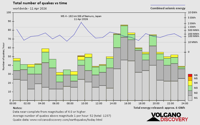 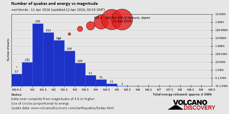 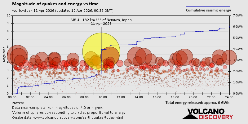 https://www.volcanodiscovery.com/earthquake/news/299727/World-Earthquake-Report-for-Saturday-11-April-2026.html https://www.volcanodiscovery.com/earthquake/news/299727/World-Earthquake-Report-for-Saturday-11-April-2026.html
0
4
Read More
|
Volcano earthquake report for Saturday, 11 Apr 2026
Webmaster
Yesterday at 11:50 PM
Volcano earthquake report for Saturday, 11 Apr 2026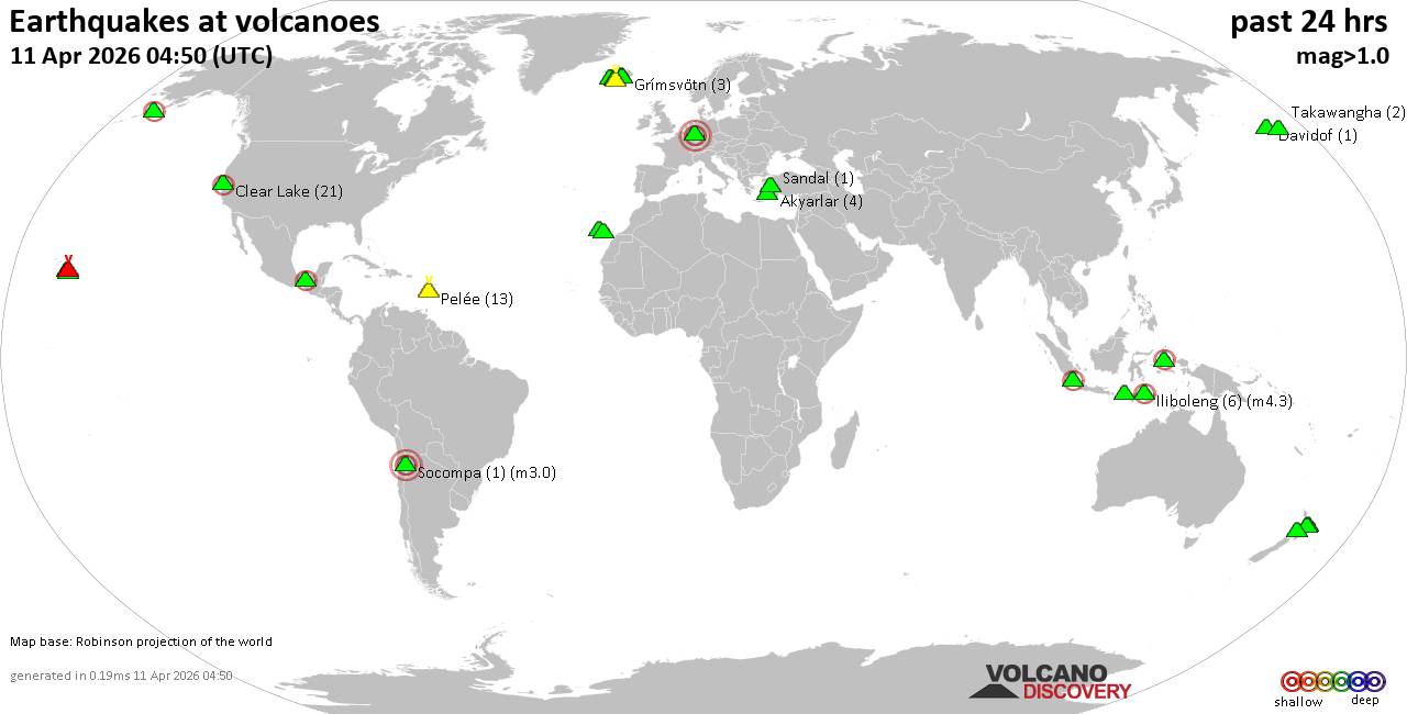 World map showing volcanoes with shallow (less than 50 km) earthquakes within 20 km radius during the past 24 hours on 11 Apr 2026 Number in brackets indicate nr of quakes. Quakes detected near: Bardarbunga (8 quakes between mag 0.5-1.7), Barva (2 quakes between mag 1.9-2.4), Clear Lake (13 quakes between mag 0.7-2.1), Coso (4 quakes between mag 0.3-1.3), El Chichón (3 quakes between mag 2.7-2.9), Etna (2 quakes between mag 1.1-1.2)
Grímsnes (6 quakes between mag 0.1-1.2), Hekla (1 quake mag 1.0), Iliboleng (10 quakes between mag 2.1-2.9), Isla San Luis (2 quakes between mag 3.7-4.0), Jailolo (1 quake mag 2.2), Katla (8 quakes between mag 0.1-1.6), Katmai (1 quake mag 1.7), Kilauea (5 quakes between mag 1.7-2.6), Krísuvík (5 quakes between mag 0.0-1.4), Latukan (2 quakes between mag 1.6-2.2), Loihi (2 quakes between mag 1.9-1.9), Mammoth Mountain (1 quake mag 1.3), Maroa (5 quakes between mag 1.6-2.4), Maunaloa (1 quake mag 2.2), Ndete Napu (1 quake mag 2.7), Nisyros (1 quake mag 2.0), Piton de la Fournaise (7 quakes between mag 0.3-1.8), Reporoa (1 quake mag 1.5), Sanbe (1 quake mag 4.0), Svartsengi (3 quakes between mag 0.5-1.0), Tambora (1 quake mag 2.2), Taupo (1 quake mag 1.9), Tenerife (12 quakes between mag 1.0-2.0), Tjörnes Fracture Zone (4 quakes between mag 0.2-1.3), Torfajökull (7 quakes between mag 0.1-1.0) (updated 23h50)
Note: Earthquakes within 20 km from and at depths less than 50 km under active volcanoes are reported. The list is not complete because many volcanoes are not monitored and/or seismic data in high resolution is not available publicly.
Volcanoes with recent earthquakes above magnitude 2 or more than 10 quakes are listed below:
Barva volcano (Costa Rica): 2 earthquakes up to magnitude 2.42 earthquakes occurred near (under) the volcano during 36 minutes, the last being recorded quake 6 hours ago. Hypocenter depths ranged between 18.00 and 13.00 km. Earthquake details: 2.4 quake Provincia de Heredia, 27 km northeast of San Jose, Costa Rica, Apr 11, 2026 11:42 am (Costa_Rica time) (13 km E) 1.9 quake Provincia de Heredia, 30 km northeast of San Jose, Costa Rica, Apr 11, 2026 12:18 pm (Costa_Rica time) (16 km ENE) All earthquakes at BarvaClear Lake volcano (California): 13 earthquakes up to magnitude 2.1Possible earthquake swarm: 13 earthquakes occurred near (under) the volcano during 23 hours, the last being recorded quake 39 minutes ago. Hypocenter depths ranged between 3.82 and 0.33 km. Earthquake details: (only 5 largest) 2.1 quake Sonoma County, 13 mi southwest of Clearlake, Lake County, California, United States, Apr 11, 2026 12:54 am (GMT -7) (16 km SSW) 1.6 quake Sonoma County, 13 mi southwest of Clearlake, Lake County, California, United States, Apr 11, 2026 11:53 am (GMT -7) (19 km S) 1.5 quake 27 mi north of Santa Rosa, Sonoma County, California, United States, Apr 10, 2026 08:43 pm (GMT -7) (17 km S) 1.3 quake 25 mi north of Santa Rosa, Sonoma County, California, United States, Apr 11, 2026 04:10 pm (GMT -7) (19 km S) 1.2 quake 25 mi north of Santa Rosa, Sonoma County, California, United States, Apr 11, 2026 11:55 am (GMT -7) (19 km S) All earthquakes at Clear LakeEl Chichón volcano (Southern Mexico): 3 earthquakes up to magnitude 2.93 earthquakes occurred near (under) the volcano during 6 hours, the last being recorded quake 16 hours ago. Hypocenter depths ranged between 3.00 and 3.00 km. Earthquake details: 2.9 quake Estado de Chiapas, 36 km southwest of Teapa, Estado de Tabasco, Mexico, Apr 11, 2026 01:32 am (GMT -6) (2 km ESE) 2.8 quake Estado de Chiapas, 36 km southwest of Teapa, Estado de Tabasco, Mexico, Apr 10, 2026 07:19 pm (GMT -6) (1 km N) 2.7 quake Estado de Chiapas, 36 km southwest of Teapa, Estado de Tabasco, Mexico, Apr 11, 2026 12:10 am (GMT -6) (1 km NNE) All earthquakes at El ChichónIliboleng volcano (Lesser Sunda Islands): 10 earthquakes up to magnitude 2.910 earthquakes occurred near (under) the volcano during 18 hours, the last being recorded quake 3 hours ago. Hypocenter depths ranged between 7.00 and 3.00 km. Earthquake details: (only 5 largest) 2.9 quake Kabupaten Flores Timur, 32 km west of Lewoleba, Indonesia, Apr 11, 2026 08:42 pm (GMT +8) (17 km SW) 2.6 quake Kabupaten Flores Timur, 31 km west of Lewoleba, Indonesia, Apr 11, 2026 01:07 pm (GMT +8) (14 km WSW) 2.5 quake Savu Sea, 18 km south of Pulau Adonara Island, East Nusa Tenggara, Indonesia, Apr 11, 2026 01:19 pm (GMT +8) (18 km SSW) 2.4 quake Savu Sea, 16 km south of Pulau Adonara Island, East Nusa Tenggara, Indonesia, Apr 12, 2026 05:10 am (GMT +8) (16 km SSW) 2.4 quake Kabupaten Flores Timur, 31 km west of Lewoleba, Indonesia, Apr 11, 2026 01:59 pm (GMT +8) (16 km SW) All earthquakes at IlibolengIsla San Luis volcano (Baja California, NW Mexico & Mexican Islands): 2 earthquakes up to magnitude 4.02 earthquakes occurred near (under) the volcano during 4 hours, the last being recorded quake 15 hours ago. Hypocenter depths ranged between 3.00 and 2.10 km. Earthquake details: 4.0 quake 140 km south of San Felipe, Estado de Baja California, Mexico, Apr 11, 2026 01:44 am (GMT -7) (16 km SE) 3.7 quake 128 km southeast of San Felipe, Estado de Baja California, Mexico, Apr 10, 2026 09:45 pm (GMT -7) (17 km ENE) All earthquakes at Isla San LuisJailolo volcano (Halmahera): magnitude 2.2 earthquakeA magnitude 2.2 earthquake occurred at the volcano 3 hours ago. The quake, which might be volcanic in origin, was located at a depth of 9.00 km depth at 9 km distance E from the volcano. Earthquake details: 2.2 quake Kabupaten Halmahera Barat, 34 km north of Ternate, Indonesia, Apr 12, 2026 05:22 am (GMT +9) (9 km E) All earthquakes at JailoloKilauea volcano (Hawai'i (Big Island)): 5 earthquakes up to magnitude 2.65 earthquakes occurred near (under) the volcano during 5 hours, the last being recorded quake 2 hours ago. Hypocenter depths ranged between 29.17 and 5.90 km. Earthquake details: 2.6 quake 35 mi southwest of Hilo, Hawaii County, Hawaii, United States, Apr 11, 2026 11:49 am (GMT -10) (16 km SW) 2.6 quake 36 mi southwest of Hilo, Hawaii County, Hawaii, United States, Apr 11, 2026 11:49 am (GMT -10) (18 km SW) 1.7 quake 36 mi southwest of Hilo, Hawaii County, Hawaii, United States, Apr 11, 2026 08:35 am (GMT -10) (17 km SW) 1.7 quake 36 mi southwest of Hilo, Hawaii County, Hawaii, United States, Apr 11, 2026 08:03 am (GMT -10) (17 km SW) 1.7 quake 28 mi southwest of Hilo, Hawaii County, Hawaii, United States, Apr 11, 2026 06:43 am (GMT -10) (18 km WNW) All earthquakes at KilaueaLatukan volcano (Mindanao): 2 earthquakes up to magnitude 2.22 earthquakes occurred near (under) the volcano during 7 minutes, the last being recorded quake 6 hours ago. Hypocenter depths ranged between 8.00 and 8.00 km. Earthquake details: 2.2 quake 44 km north of Midsayap, Cotabato, Soccsksargen, Philippines, Apr 12, 2026 01:44 am (GMT +8) (8 km SSE) 1.6 quake 41 km north of Midsayap, Cotabato, Soccsksargen, Philippines, Apr 12, 2026 01:51 am (GMT +8) (11 km SSE) All earthquakes at LatukanMaroa volcano (New Zealand): 5 earthquakes up to magnitude 2.45 earthquakes occurred near (under) the volcano during 3 hours, the last being recorded quake 7 hours ago. Hypocenter depths ranged between 4.70 and 3.60 km. Earthquake details: 2.4 quake 18 km northeast of Taupo, Waikato, New Zealand, Apr 12, 2026 02:17 am (GMT +12) (16 km SE) 2.0 quake 19 km northeast of Taupo, Waikato, New Zealand, Apr 12, 2026 01:24 am (GMT +12) (15 km SE) 1.7 quake 19 km northeast of Taupo, Waikato, New Zealand, Apr 12, 2026 04:25 am (GMT +12) (17 km SE) 1.6 quake 18 km northeast of Taupo, Waikato, New Zealand, Apr 12, 2026 01:42 am (GMT +12) (16 km SE) 1.6 quake 18 km northeast of Taupo, Waikato, New Zealand, Apr 12, 2026 01:23 am (GMT +12) (17 km SE) All earthquakes at MaroaMaunaloa volcano (Hawai'i (Big Island)): magnitude 2.2 earthquakeA magnitude 2.2 earthquake occurred at the volcano 20 hours ago. The quake, which might be volcanic in origin, was located at a depth of 5.78 km depth at 16 km distance ESE from the volcano. Earthquake details: 2.2 quake 33 mi southwest of Hilo, Hawaii County, Hawaii, United States, Apr 10, 2026 05:54 pm (GMT -10) (16 km ESE) All earthquakes at MaunaloaNdete Napu volcano (Flores): magnitude 2.7 earthquakeA magnitude 2.7 earthquake occurred at the volcano 17 hours ago. The quake, which might be volcanic in origin, was located at a depth of 10.00 km depth at 18 km distance WNW from the volcano. Earthquake details: 2.7 quake 24 km north of Ende, Kabupaten Ende, East Nusa Tenggara, Indonesia, Apr 11, 2026 02:20 pm (GMT +8) (18 km WNW) All earthquakes at Ndete NapuSanbe volcano (Honshu): magnitude 4.0 earthquakeA magnitude 4.0 earthquake occurred at the volcano 7 hours ago. The quake, which might be volcanic in origin, was located at a depth of 10.00 km depth at 8 km distance ESE from the volcano. Earthquake details: 4.0 quake 30 km south of Izumo, Shimane, Japan, Apr 12, 2026 01:30 am (GMT +9) (8 km ESE) All earthquakes at SanbeTambora volcano (Sumbawa): magnitude 2.2 earthquakeA magnitude 2.2 earthquake occurred at the volcano 21 hours ago. The quake, which might be volcanic in origin, was located at a depth of 26.00 km depth at 10 km distance WNW from the volcano. Earthquake details: 2.2 quake Kabupaten Dompu, 61 km northeast of Sumbawa Besar, Indonesia, Apr 11, 2026 10:21 am (GMT +8) (10 km WNW) All earthquakes at TamboraTenerife volcano (Canary Islands): 12 earthquakes up to magnitude 2.0Possible earthquake swarm: 12 earthquakes occurred near (under) the volcano during 11 hours, the last being recorded quake 5 hours ago. Hypocenter depths ranged between 11.00 and 2.00 km. Earthquake details: (only 5 largest) 2.0 quake 8.4 km southeast of La Orotava, Santa Cruz de Tenerife, Canary Islands, Spain, Apr 11, 2026 07:55 pm (GMT +1) (18 km ENE) 1.6 quake 8.3 km southeast of La Orotava, Santa Cruz de Tenerife, Canary Islands, Spain, Apr 11, 2026 07:08 pm (GMT +1) (17 km ENE) 1.6 quake 7.9 km southeast of La Orotava, Santa Cruz de Tenerife, Canary Islands, Spain, Apr 11, 2026 06:41 pm (GMT +1) (17 km ENE) 1.6 quake 8.3 km southeast of La Orotava, Santa Cruz de Tenerife, Canary Islands, Spain, Apr 11, 2026 05:59 pm (GMT +1) (17 km ENE) 1.3 quake 7.6 km southeast of La Orotava, Santa Cruz de Tenerife, Canary Islands, Spain, Apr 11, 2026 07:57 pm (GMT +1) (19 km ENE) All earthquakes at Tenerifehttps://www.volcanodiscovery.com/earthquakes-volcanoes/news/299714/Volcano-earthquake-report-for-Saturday-11-Apr-2026.html
0
4
Read More
|
Moderate earthquake of magnitude 4.9 just reported 45 km west of Ancud, Chile
Webmaster
Yesterday at 11:04 PM
Moderate earthquake of magnitude 4.9 just reported 45 km west of Ancud, Chile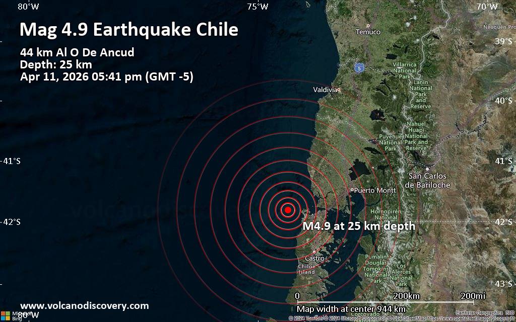 An earthquake of magnitude 4.9 occurred in the afternoon on Saturday, April 11th, 2026, at 5:41 pm local time near Ancud, Provincia de Chiloé, Region de los Lagos, Chile, as reported by The National Seismological Center (Centro Sismológico Nacional, CSN) of the University of Chile.
According to preliminary data, the quake was located at a shallow depth of 25. km. Shallow earthquakes are felt more strongly than deeper ones as they are closer to the surface. The exact magnitude, epicenter, and depth of the quake might be revised within the next few hours or minutes as seismologists review data and refine their calculations, or as other agencies issue their report.
Our monitoring service identified a second report from the citizen-seismograph network of RaspberryShake which listed the quake at magnitude 4.9 as well.
Based on the preliminary seismic data, the quake should not have caused any significant damage, but was probably felt by many people as light vibration in the area of the epicenter.
Weak shaking might have been felt in Ancud (pop. 40,800) located 45 km from the epicenter, Maullin (pop. 15,600) 66 km away, Dalcahue (pop. 13,100) 86 km away, Castro (pop. 41,700) 88 km away, and Calbuco (pop. 33,000) 101 km away.
VolcanoDiscovery will automatically update magnitude and depth if these change and follow up if other significant news about the quake become available. If you’re in the area, please send us your experience through our reporting mechanism, either online or via our mobile app. This will help us provide more first-hand updates to anyone around the globe who wants to know more about this quake.
Earthquake data: Date & time: Apr 11, 2026 05:41 pm (GMT -5) local time (11 Apr 2026 22:41 GMT)Magnitude: 4.9 Depth: 25.00 km Epicenter latitude / longitude: 41.8°S / 74.35°W  (Provincia de Chiloé, Region de los Lagos, Chile) Primary data source: CSNhttps://www.volcanodiscovery.com/earthquake/news/299771/Moderate-earthquake-of-magnitude-49-just-reported-45-km-west-of-Ancud-Chile.html
0
7
Read More
|
Monday: Light Rain Showers, Minimum Temperature: 2°C (36°F) Maximum Temperature: 13°C (56°F)
Webmaster
Yesterday at 09:03 PM
Maximum Temperature: 13°C (56°F), Minimum Temperature: 2°C (36°F), Wind Direction: southerly, Wind Speed: 4mph, Visibility: Good, Pressure: 1013mb, Humidity: 65%, UV Risk: 4, Pollution: Low, Sunrise: 06:15 BST, Sunset: 20:05 BST Source: Monday: Light Rain Showers, Minimum Temperature: 2°C (36°F) Maximum Temperature: 13°C (56°F)
0
20
Read More
|
Sunday: Light Rain Showers, Minimum Temperature: 2°C (36°F) Maximum Temperature: 13°C (56°F)
Webmaster
Yesterday at 09:03 PM
Maximum Temperature: 13°C (56°F), Minimum Temperature: 2°C (36°F), Wind Direction: south-westerly, Wind Speed: 12mph, Visibility: Very Good, Pressure: 1005mb, Humidity: 64%, UV Risk: 3, Pollution: Low, Sunrise: 06:17 BST, Sunset: 20:04 BST Source: Sunday: Light Rain Showers, Minimum Temperature: 2°C (36°F) Maximum Temperature: 13°C (56°F)
0
17
Read More
|
Moderate magnitude 4.6 earthquake 32 km southwest of Tambolaka, Indonesia
Webmaster
Yesterday at 07:10 PM
Moderate magnitude 4.6 earthquake 32 km southwest of Tambolaka, Indonesia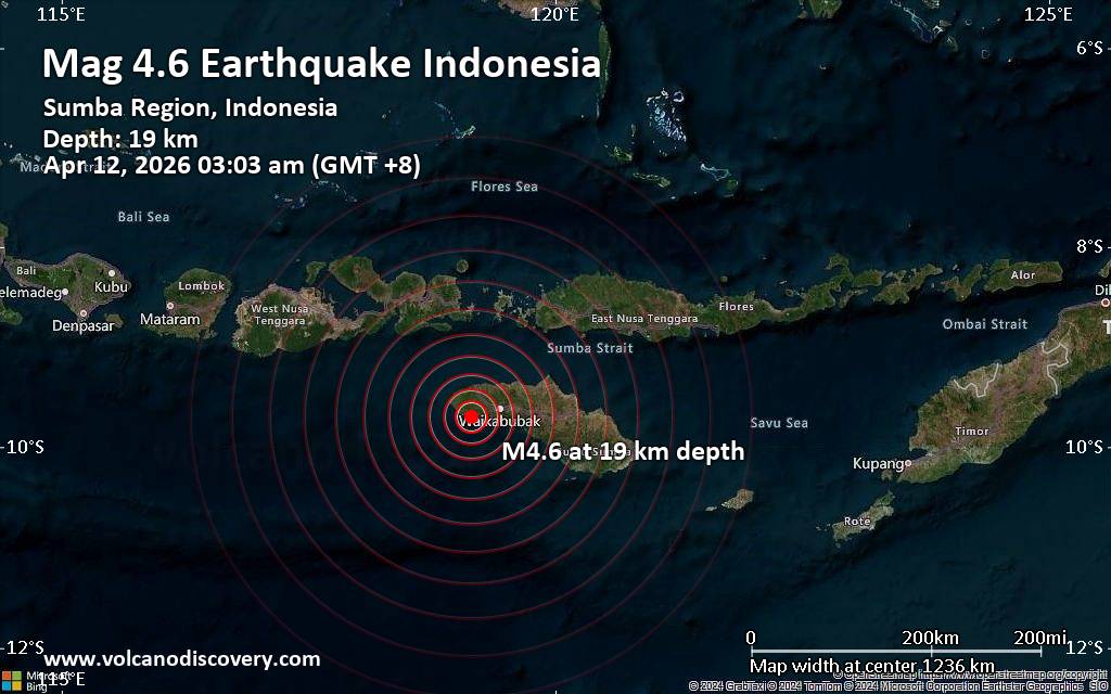 A shallow magnitude 4.6 earthquake was reported early morning near Tambolaka, Southwest Sumba Regency, East Nusa Tenggara, Indonesia.
According to Indonesia's Meteorology, Climatology, and Geophysical Agency, the quake hit on Sunday, April 12th, 2026, at 3:03 am local time at a shallow depth of 19. km. Shallow earthquakes are felt more strongly than deeper ones as they are closer to the surface. The exact magnitude, epicenter, and depth of the quake might be revised within the next few hours or minutes as seismologists review data and refine their calculations, or as other agencies issue their report.
Our monitoring service identified a second report from the citizen-seismograph network of RaspberryShake which listed the quake at magnitude 4.6 as well.
Based on the preliminary seismic data, the quake should not have caused any significant damage, but was probably felt by many people as light vibration in the area of the epicenter.
Weak shaking might have been felt in Tambolaka (pop. 35,800) located 32 km from the epicenter.
VolcanoDiscovery will automatically update magnitude and depth if these change and follow up if other significant news about the quake become available. If you’re in the area, please send us your experience through our reporting mechanism, either online or via our mobile app. This will help us provide more first-hand updates to anyone around the globe who wants to know more about this quake.
Earthquake data: Date & time: Apr 12, 2026 03:03 am (GMT +8) local time (11 Apr 2026 19:03 GMT)Magnitude: 4.6 Depth: 19.00 km Epicenter latitude / longitude: 9.7°S / 119.15°E  ( Kabupaten Sumba Barat Daya, East Nusa Tenggara, Indonesia) Primary data source: BMKGhttps://www.volcanodiscovery.com/earthquake/news/299758/Moderate-magnitude-46-earthquake-32-km-southwest-of-Tambolaka-Indonesia.html
0
10
Read More
|
World Earthquake Report for April 2026
Webmaster
Yesterday at 06:00 PM
World Earthquake Report for April 2026 Worldwide earthquakes above magnitude 5.5 during April 2026 Magnitude 9+: none Magnitude 8+: none Magnitude 7+: 1 earthquake Magnitude 6+: 3 earthquakes Magnitude 5+: 78 earthquakes Magnitude 4+: 579 earthquakes Magnitude 3+: 2886 earthquakes Magnitude 2+: 4806 earthquakes No quakes of magnitude 8 or higher List of 10 largest earthquakes in the world during April 2026:Thursday, Apr 2, 2026, at 07:48 am (Jayapura time) - Thursday, Apr 2, 2026, at 12:23 pm (Jayapura time) - Wednesday, Apr 1, 2026, at 06:20 am (Lima time) - Thursday, Apr 2, 2026, at 11:13 pm (Jayapura time) - Thursday, Apr 2, 2026, at 11:34 pm (Jayapura time) - Friday, Apr 3, 2026, at 08:42 pm (GMT +4:30) - Thursday, Apr 2, 2026, at 12:17 pm (Jayapura time) - Wednesday, Apr 1, 2026, at 06:08 pm (GMT +12) - Friday, Apr 3, 2026, at 09:22 am (Jayapura time) - Thursday, Apr 2, 2026, at 08:34 pm (Jayapura time) - Earthquake stats: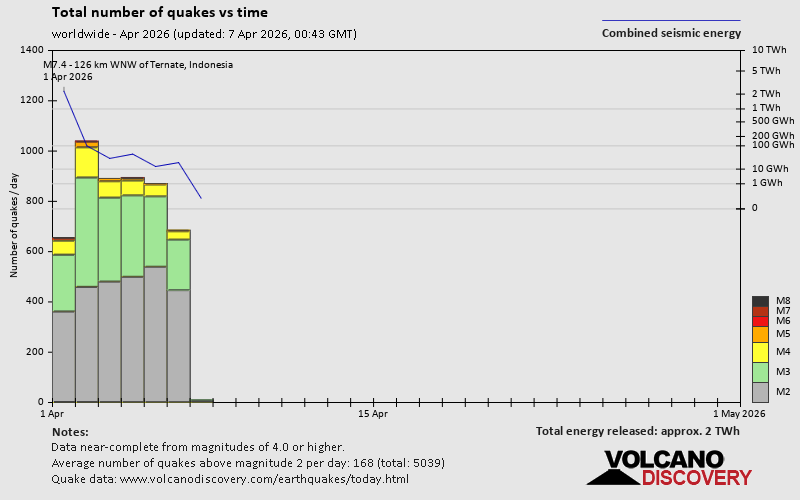 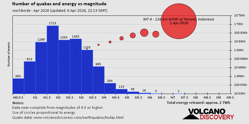 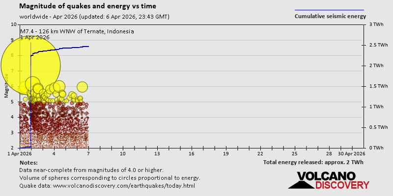 https://www.volcanodiscovery.com/view_news/299131/World-Earthquake-Report-for-April-2026.html https://www.volcanodiscovery.com/view_news/299131/World-Earthquake-Report-for-April-2026.html
0
4
Read More
|
|
Forums60
Topics768,769
Posts803,535
Members2,958
| |
Most Online17,963
Jan 15th, 2026
|
|
|
|
|
Copyright 1996 - 2026 by David Cottle. Designed by David Bate Jr. All Rights Reserved.
By using this forum, the user agrees not to transfer any data or technical information received under the agreement, to any other entity without the express approval of the AUS-CITY Forum Admins and/or authors of individual posts (Forum Admins and DoD/USSPACECOM for the analysis of satellite tracking data).
Two-line elements (TLE) and all other satellite data presented and distributed via this forum and e-mail lists of AUS-CITY are distributed with permission from DoD/USSTRATCOM.


Reprise Hosting

|

|


 - Click image for larger picture.")


