|
|
|
0 members (),
1,834
guests, and
23
robots. |
|
Key:
Admin,
Global Mod,
Mod
|
|
S |
M |
T |
W |
T |
F |
S |
|
1
|
2
|
3
|
4
|
5
|
6
|
7
|
|
8
|
9
|
10
|
11
|
12
|
13
|
14
|
|
15
|
16
|
17
|
18
|
19
|
20
|
21
|
|
22
|
23
|
24
|
25
|
26
|
27
|
28
|
|
29
|
30
|
31
|
|
|
|
|
|
There are no members with birthdays on this day. |
 Volcano earthquake report for Saturday, 14 Mar 2026
Webmaster
7 hours ago
Volcano earthquake report for Saturday, 14 Mar 2026
Webmaster
7 hours ago
Volcano earthquake report for Saturday, 14 Mar 2026 World map showing volcanoes with shallow (less than 50 km) earthquakes within 20 km radius during the past 24 hours on 14 Mar 2026 Number in brackets indicate nr of quakes. Quakes detected near: Akyarlar (1 quake mag 2.4), Balut (1 quake mag 3.0), Bardarbunga (4 quakes between mag 0.3-1.5), Biliran (1 quake mag 2.6), Clear Lake (23 quakes between mag 0.2-1.8), Coatepeque (6 quakes between mag 1.6-3.1)
Coso (2 quakes between mag 0.3-1.1), El Chichón (1 quake mag 2.2), Eldey (1 quake mag 1.0), Geureudong (1 quake mag 2.2), Hiuchi (2 quakes between mag 3.0-3.0), Katla (4 quakes between mag 0.9-1.5), Kenger (2 quakes between mag 1.3-1.9), Kilauea (3 quakes between mag 1.1-1.9), Kupreanof (1 quake mag 1.4), Lavic Lake (1 quake mag 1.4), Lawu (1 quake mag 2.5), Loihi (1 quake mag 1.7), Long Valley (1 quake mag 2.0), Maunaloa (1 quake mag 1.7), Mombacho (1 quake mag 2.3), Mount Rainier (1 quake mag 1.0), Paco (1 quake mag 1.9), Paluweh (1 quake mag 2.1), Rinjani (1 quake mag 2.4), San Cristobal (1 quake mag 1.3), San Salvador (2 quakes between mag 2.1-2.3), Sorikmarapi (1 quake mag 2.4), Sousaki (1 quake mag 3.4), Taupo (1 quake mag 1.1), Tenerife (8 quakes between mag 1.2-1.7), Turrialba (1 quake mag 1.1), Usulután (1 quake mag 2.5), Vesuvius (1 quake mag 1.2), Whale Island (1 quake mag 2.0), White Island (1 quake mag 2.1) (updated 03h50)
Note: Earthquakes within 20 km from and at depths less than 50 km under active volcanoes are reported. The list is not complete because many volcanoes are not monitored and/or seismic data in high resolution is not available publicly.
Volcanoes with recent earthquakes above magnitude 2 or more than 10 quakes are listed below:
Akyarlar volcano (Turkey): magnitude 2.4 earthquakeA magnitude 2.4 earthquake occurred at the volcano 16 hours ago. The quake, which might be volcanic in origin, was located at a depth of 12.00 km depth at 10 km distance S from the volcano. Earthquake details: 2.4 quake 2 km east of Kos, Dodecanese, South Aegean, Greece, Mar 13, 2026 01:59 pm (GMT +2) (10 km S) All earthquakes at AkyarlarBalut volcano (Mindanao): magnitude 3.0 earthquakeA magnitude 3.0 earthquake occurred at the volcano 13 hours ago. The quake, which might be volcanic in origin, was located at a depth of 10.00 km depth at 18 km distance NW from the volcano. Earthquake details: Reported seismic-like event (likely no quake): 25 km northwest of Sarangani, Davao Occidental, Davao, Philippines, Mar 13, 2026 11:06 pm (GMT +8) (18 km NW) All earthquakes at BalutBiliran volcano (Central Philippines): magnitude 2.6 earthquakeA magnitude 2.6 earthquake occurred at the volcano 5 hours ago. The quake, which might be volcanic in origin, was located at a depth of 3.00 km depth at 18 km distance W from the volcano. Earthquake details: 2.6 quake Philippine Sea, 12 km southwest of Biliran Island, Philippines, Mar 14, 2026 06:22 am (GMT +8) (18 km W) All earthquakes at BiliranClear Lake volcano (California): 23 earthquakes up to magnitude 1.8Possible earthquake swarm: 23 earthquakes occurred near (under) the volcano during 23 hours, the last being recorded quake 36 minutes ago. Hypocenter depths ranged between 2.96 and 0.72 km. Earthquake details: (only 5 largest) 1.8 quake Sonoma County, 14 mi southwest of Clearlake, Lake County, California, United States, Mar 13, 2026 01:43 am (GMT -7) (16 km SSW) 1.7 quake Sonoma County, 15 mi southwest of Clearlake, Lake County, California, United States, Mar 13, 2026 06:42 am (GMT -7) (18 km SSW) 1.6 quake Sonoma County, 14 mi southwest of Clearlake, Lake County, California, United States, Mar 13, 2026 07:28 pm (GMT -7) (16 km SSW) 1.6 quake Sonoma County, 14 mi southwest of Clearlake, Lake County, California, United States, Mar 13, 2026 05:16 pm (GMT -7) (16 km SSW) 1.3 quake 27 mi north of Santa Rosa, Sonoma County, California, United States, Mar 13, 2026 03:12 pm (GMT -7) (18 km SSW) All earthquakes at Clear LakeCoatepeque volcano (El Salvador): 6 earthquakes up to magnitude 3.16 earthquakes occurred near (under) the volcano during 3 hours, the last being recorded quake 4 hours ago. Hypocenter depths ranged between 13.00 and 6.00 km. Earthquake details: (only 5 largest) 3.1 quake Departamento de La Libertad, 31 km west of San Salvador, El Salvador, Mar 13, 2026 02:50 pm (GMT -6) (16 km SE) 2.4 quake Departamento de La Libertad, 30 km west of San Salvador, El Salvador, Mar 13, 2026 03:01 pm (GMT -6) (14 km SE) 2.4 quake Departamento de Santa Ana, 31 km west of San Salvador, El Salvador, Mar 13, 2026 02:57 pm (GMT -6) (14 km SE) 1.9 quake 21 km northwest of Santa Tecla, Departamento de La Libertad, El Salvador, Mar 13, 2026 04:42 pm (GMT -6) (15 km SE) 1.9 quake 22 km northwest of Santa Tecla, Departamento de La Libertad, El Salvador, Mar 13, 2026 03:21 pm (GMT -6) (14 km SE) All earthquakes at CoatepequeEl Chichón volcano (Southern Mexico): magnitude 2.2 earthquakeA magnitude 2.2 earthquake occurred at the volcano 8 hours ago. The quake, which might be volcanic in origin, was located at a depth of 3.00 km depth at 1 km distance NW from the volcano. Earthquake details: 2.2 quake Estado de Chiapas, 37 km southwest of Teapa, Estado de Tabasco, Mexico, Mar 13, 2026 01:54 pm (GMT -6) (1 km NW) All earthquakes at El ChichónGeureudong volcano (Sumatra): magnitude 2.2 earthquakeA magnitude 2.2 earthquake occurred at the volcano 9 hours ago. The quake, which might be volcanic in origin, was located at a depth of 4.00 km depth at 6 km distance SW from the volcano. Earthquake details: 2.2 quake Kabupaten Bener Meriah, 52 km south of Bireun, Indonesia, Mar 14, 2026 01:51 am (GMT +7) (6 km SW) All earthquakes at GeureudongHiuchi volcano (Honshu): 2 earthquakes up to magnitude 3.02 earthquakes occurred near (under) the volcano during 3 hours, the last being recorded quake 9 hours ago. Hypocenter depths ranged between 10.00 and 10.00 km. Earthquake details: Reported seismic-like event (likely no quake): 14 km north of Katashina, Gunma, Japan, Mar 14, 2026 03:23 am (GMT +9) (2 km NW) Reported seismic-like event (likely no quake): 32 km southeast of Minamiuonuma, Niigata, Japan, Mar 14, 2026 12:10 am (GMT +9) (7 km W) All earthquakes at HiuchiLawu volcano (Central Java): magnitude 2.5 earthquakeA magnitude 2.5 earthquake occurred at the volcano 17 hours ago. The quake, which might be volcanic in origin, was located at a depth of 47.00 km depth at 14 km distance E from the volcano. Earthquake details: 2.5 quake Kabupaten Magetan, 23 km west of Madiun, Kota Madiun, Jawa Timur, Indonesia, Mar 13, 2026 06:10 pm (GMT +7) (14 km E) All earthquakes at LawuMombacho volcano (Nicaragua): magnitude 2.3 earthquakeA magnitude 2.3 earthquake occurred at the volcano 24 hours ago. The quake, which might be volcanic in origin, was located at a depth of 5.00 km depth at 4 km distance WSW from the volcano. Earthquake details: 2.3 quake 15 km south of Granada, Departamento de Granada, Nicaragua, Mar 12, 2026 10:11 pm (GMT -6) (4 km WSW) All earthquakes at MombachoPaluweh volcano (Lesser Sunda Islands): magnitude 2.1 earthquakeA magnitude 2.1 earthquake occurred at the volcano 23 hours ago. The quake, which might be volcanic in origin, was located at a depth of 4.00 km depth at 19 km distance W from the volcano. Earthquake details: 2.1 quake Flores Sea, 58 km north of Ende, Kabupaten Ende, East Nusa Tenggara, Indonesia, Mar 13, 2026 01:12 pm (GMT +8) (19 km W) All earthquakes at PaluwehRinjani volcano (Lombok): magnitude 2.4 earthquakeA magnitude 2.4 earthquake occurred at the volcano 10 hours ago. The quake, which might be volcanic in origin, was located at a depth of 18.00 km depth at 18 km distance SSE from the volcano. Earthquake details: 2.4 quake 10.5 km north of Selong, Kabupaten Lombok Timur, West Nusa Tenggara, Indonesia, Mar 14, 2026 02:12 am (GMT +8) (18 km SSE) All earthquakes at RinjaniSan Salvador volcano (El Salvador): 2 earthquakes up to magnitude 2.32 earthquakes occurred near (under) the volcano during 14 hours, the last being recorded quake 7 hours ago. Hypocenter depths ranged between 14.00 and 7.00 km. Earthquake details: 2.3 quake Departamento de La Libertad, 28 km west of San Salvador, El Salvador, Mar 13, 2026 03:02 pm (GMT -6) (16 km WNW) 2.1 quake Departamento de La Libertad, 26 km northwest of San Salvador, El Salvador, Mar 13, 2026 01:25 am (GMT -6) (13 km WNW) All earthquakes at San SalvadorSorikmarapi volcano (Sumatra): magnitude 2.4 earthquakeA magnitude 2.4 earthquake occurred at the volcano 7 hours ago. The quake, which might be volcanic in origin, was located at a depth of 4.00 km depth at 16 km distance S from the volcano. Earthquake details: 2.4 quake Kabupaten Mandailing Natal, 99 km south of Padangsidempuan, Indonesia, Mar 14, 2026 03:37 am (GMT +7) (16 km S) All earthquakes at SorikmarapiSousaki volcano (Greece): magnitude 3.4 earthquakeA magnitude 3.4 earthquake occurred at the volcano 13 hours ago. The quake, which might be volcanic in origin, was located at a depth of 10.00 km depth at 19 km distance S from the volcano. Earthquake details: 3.4 quake Peloponnese, 59 km southwest of Athens, Nomarchia Athinas, Attica, Greece, Mar 13, 2026 04:54 pm (GMT +2) (19 km S) All earthquakes at SousakiUsulután volcano (El Salvador): magnitude 2.5 earthquakeA magnitude 2.5 earthquake occurred at the volcano 8 hours ago. The quake, which might be volcanic in origin, was located at a depth of 5.00 km depth at 2 km distance NNW from the volcano. Earthquake details: 2.5 quake 11 km northwest of Usulutan, Departamento de Usulutan, El Salvador, Mar 13, 2026 01:37 pm (GMT -6) (2 km NNW) All earthquakes at UsulutánWhite Island volcano (New Zealand): magnitude 2.1 earthquakeA magnitude 2.1 earthquake occurred at the volcano 12 hours ago. The quake, which might be volcanic in origin, was located at a depth of 5.00 km depth at 18 km distance SSE from the volcano. Earthquake details: 2.1 quake South Pacific Ocean, 40 km northeast of Whakatane, Bay of Plenty, New Zealand, Mar 14, 2026 05:05 am (GMT +13) (18 km SSE) All earthquakes at White Islandhttps://www.volcanodiscovery.com/earthquakes-volcanoes/news/297576/Volcano-earthquake-report-for-Saturday-14-Mar-2026.html
0
18
Read More
|
Small tremor of magnitude 2.9 just reported 4 km south of Assen, Netherlands
Webmaster
9 hours ago
Small tremor of magnitude 2.9 just reported 4 km south of Assen, Netherlands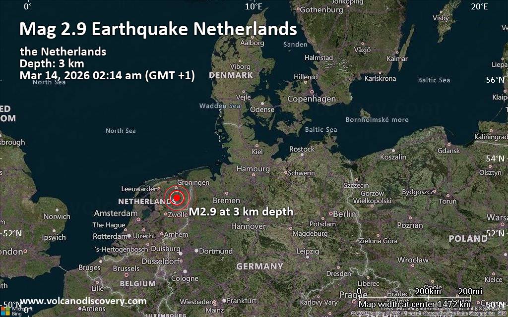 A magnitude 2.9 earthquake near Assen, Assen Municipality, Provincie Drenthe, Netherlands, was reported only 22 minutes ago by the European-Mediterranean Seismological Centre (EMSC), considered one of the key international agencies that monitor seismic activity worldwide. The earthquake occurred at a very shallow depth of 3. km beneath the epicenter early morning on Saturday, March 14th, 2026, at 2:14 am local time. The exact magnitude, epicenter, and depth of the quake might be revised within the next few hours or minutes as seismologists review data and refine their calculations, or as other agencies issue their report.
Based on the preliminary seismic data, the quake should not have caused any significant damage, but was probably felt by many people as light vibration in the area of the epicenter.
Weak shaking might have been felt in Assen (pop. 68,800) located 4 km from the epicenter. In Stadskanaal (pop. 20,000, 25 km away), Hoogezand (pop. 21,500, 26 km away), Leek (pop. 19,700, 26 km away), Veendam (pop. 28,200, 26 km away), Hoogeveen (pop. 38,800, 27 km away), Groningen (pop. 244,800, 29 km away), Emmen (pop. 57,000, 30 km away), and Drachten (pop. 45,200, 36 km away), the quake was probably not felt.
Earthquake data: Date & time: Mar 14, 2026 02:14 am (GMT +1) local time (14 Mar 2026 01:14 GMT)Magnitude: 2.9 Depth: 3.00 km Epicenter latitude / longitude: 52.96°N / 6.57°E  ( Provincie Drenthe, Netherlands) Primary data source: EMSChttps://www.volcanodiscovery.com/earthquake/news/297577/Small-tremor-of-magnitude-29-just-reported-4-km-south-of-Assen-Netherlands.html
0
64
Read More
|
World Earthquake Report for Friday, 13 March 2026
Webmaster
10 hours ago
World Earthquake Report for Friday, 13 March 2026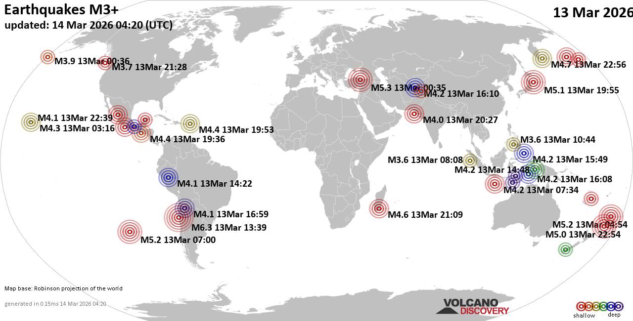 Worldwide earthquakes above magnitude 3 during the past 24 hours on 14 Mar 2026 Magnitude 6+: 1 earthquake Magnitude 5+: 5 earthquakes Magnitude 4+: 38 earthquakes Magnitude 3+: 192 earthquakes Magnitude 2+: 368 earthquakes No quakes of magnitude 7 or higher 10 largest earthquakes in the world (13 Mar 2026)Friday, Mar 13, 2026, at 09:39 am (GMT -4) - Friday, Mar 13, 2026, at 03:35 am (Istanbul time) - Friday, Mar 13, 2026, at 05:54 pm (GMT +13) - Friday, Mar 13, 2026, at 12:00 am (GMT -7) - Saturday, Mar 14, 2026, at 04:55 am (GMT +9) - Saturday, Mar 14, 2026, at 10:54 am (GMT +12) - Thursday, Mar 12, 2026, at 06:30 pm (GMT -9) - Saturday, Mar 14, 2026, at 10:56 am (GMT +12) - Saturday, Mar 14, 2026, at 04:15 am (GMT +12) - Saturday, Mar 14, 2026, at 12:09 am (Antananarivo time) - Earthquakes reported feltFriday, Mar 13, 2026, at 09:39 am (GMT -4) - Friday, Mar 13, 2026, at 03:35 am (Istanbul time) - Thursday, Mar 12, 2026, at 05:16 pm (Honolulu time) - Friday, Mar 13, 2026, at 03:53 pm (GMT -4) - Friday, Mar 13, 2026, at 04:25 am (GMT +2) - Saturday, Mar 14, 2026, at 12:09 am (Antananarivo time) - Friday, Mar 13, 2026, at 01:36 pm (GMT -6) - Friday, Mar 13, 2026, at 09:55 am (GMT -6) - Friday, Mar 13, 2026, at 12:38 pm (GMT +2) - Friday, Mar 13, 2026, at 05:25 am (GMT -7) - Friday, Mar 13, 2026, at 03:47 am (GMT +3) - Friday, Mar 13, 2026, at 10:43 am (GMT -3) - Friday, Mar 13, 2026, at 01:59 pm (GMT +2) - Saturday, Mar 14, 2026, at 04:55 am (GMT +9) - Saturday, Mar 14, 2026, at 11:36 am (GMT +12) - Friday, Mar 13, 2026, at 01:35 pm (GMT -7) - Friday, Mar 13, 2026, at 11:19 pm (Kolkata time) - Earthquake stats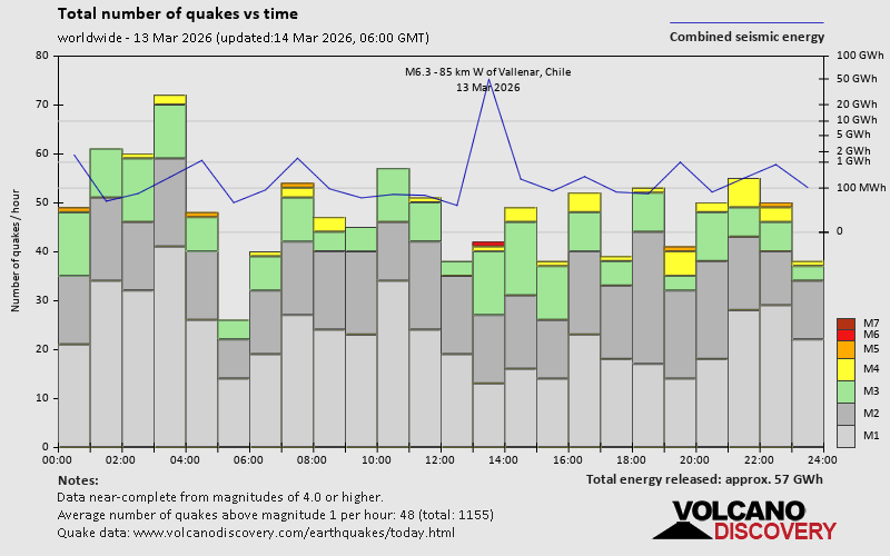  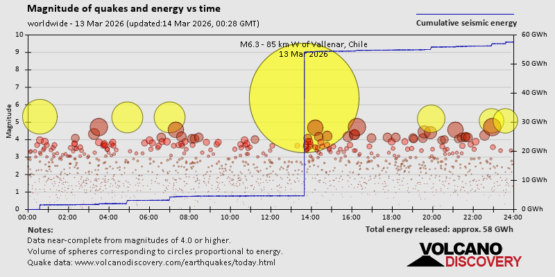 https://www.volcanodiscovery.com/earthquake/news/297493/World-Earthquake-Report-for-Friday-13-March-2026.html https://www.volcanodiscovery.com/earthquake/news/297493/World-Earthquake-Report-for-Friday-13-March-2026.html
0
15
Read More
|
Volcano earthquake report for Friday, 13 Mar 2026
Webmaster
Yesterday at 11:50 PM
Volcano earthquake report for Friday, 13 Mar 2026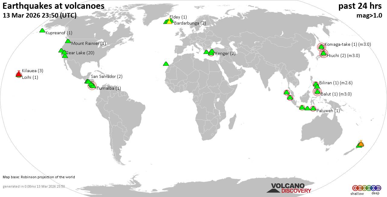 World map showing volcanoes with shallow (less than 50 km) earthquakes within 20 km radius during the past 24 hours on 13 Mar 2026 Number in brackets indicate nr of quakes. Quakes detected near: Akyarlar (1 quake mag 2.4), Balut (1 quake mag 3.0), Bardarbunga (2 quakes between mag 0.3-1.0), Biliran (1 quake mag 2.6), Clear Lake (20 quakes between mag 0.2-1.8), Coatepeque (5 quakes between mag 1.9-3.1)
Eldey (1 quake mag 1.0), Geureudong (1 quake mag 2.2), Grímsnes (2 quakes between mag 0.0-1.0), Hiuchi (2 quakes between mag 3.0-3.0), Katla (5 quakes between mag 0.3-1.5), Kenger (2 quakes between mag 1.3-1.9), Kilauea (3 quakes between mag 1.1-2.2), Komaga-take (1 quake mag 3.0), Kupreanof (1 quake mag 1.4), Lavic Lake (1 quake mag 1.4), Lawu (1 quake mag 2.5), Loihi (1 quake mag 1.7), Long Valley (1 quake mag 2.0), Mombacho (1 quake mag 2.3), Mount Rainier (1 quake mag 1.0), Paco (1 quake mag 1.9), Paluweh (1 quake mag 2.1), Rinjani (1 quake mag 2.4), San Salvador (2 quakes between mag 2.1-2.3), Sorikmarapi (1 quake mag 2.4), Sousaki (1 quake mag 3.4), Taupo (1 quake mag 1.1), Tenerife (4 quakes between mag 1.0-1.6), Tenorio (1 quake mag 3.1), Turrialba (1 quake mag 1.1), Usulután (1 quake mag 2.5), Whale Island (1 quake mag 2.0), White Island (1 quake mag 2.1) (updated 23h50)
Note: Earthquakes within 20 km from and at depths less than 50 km under active volcanoes are reported. The list is not complete because many volcanoes are not monitored and/or seismic data in high resolution is not available publicly.
Volcanoes with recent earthquakes above magnitude 2 or more than 10 quakes are listed below:
Akyarlar volcano (Turkey): magnitude 2.4 earthquakeA magnitude 2.4 earthquake occurred at the volcano 12 hours ago. The quake, which might be volcanic in origin, was located at a depth of 12.00 km depth at 10 km distance S from the volcano. Earthquake details: 2.4 quake 2 km east of Kos, Dodecanese, South Aegean, Greece, Mar 13, 2026 01:59 pm (GMT +2) (10 km S) All earthquakes at AkyarlarBalut volcano (Mindanao): magnitude 3.0 earthquakeA magnitude 3.0 earthquake occurred at the volcano 9 hours ago. The quake, which might be volcanic in origin, was located at a depth of 10.00 km depth at 18 km distance NW from the volcano. Earthquake details: Reported seismic-like event (likely no quake): 25 km northwest of Sarangani, Davao Occidental, Davao, Philippines, Mar 13, 2026 11:06 pm (GMT +8) (18 km NW) All earthquakes at BalutBiliran volcano (Central Philippines): magnitude 2.6 earthquakeA magnitude 2.6 earthquake occurred at the volcano 1 hour 28 minutes ago. The quake, which might be volcanic in origin, was located at a depth of 3.00 km depth at 18 km distance W from the volcano. Earthquake details: 2.6 quake Philippine Sea, 12 km southwest of Biliran Island, Philippines, Mar 14, 2026 06:22 am (GMT +8) (18 km W) All earthquakes at BiliranClear Lake volcano (California): 20 earthquakes up to magnitude 1.8Possible earthquake swarm: 20 earthquakes occurred near (under) the volcano during 20 hours, the last being recorded quake 1 hour 37 minutes ago. Hypocenter depths ranged between 2.96 and 0.72 km. Earthquake details: (only 5 largest) 1.8 quake Sonoma County, 14 mi southwest of Clearlake, Lake County, California, United States, Mar 13, 2026 01:43 am (GMT -7) (16 km SSW) 1.7 quake Sonoma County, 15 mi southwest of Clearlake, Lake County, California, United States, Mar 13, 2026 06:42 am (GMT -7) (18 km SSW) 1.3 quake 27 mi north of Santa Rosa, Sonoma County, California, United States, Mar 13, 2026 03:12 pm (GMT -7) (18 km SSW) 1.1 quake Lake County, 28 mi north of Santa Rosa, Sonoma County, California, United States, Mar 13, 2026 12:34 am (GMT -7) (15 km S) 1.0 quake Lake County, 25 mi north of Santa Rosa, Sonoma County, California, United States, Mar 12, 2026 09:09 pm (GMT -7) (19 km S) All earthquakes at Clear LakeCoatepeque volcano (El Salvador): 5 earthquakes up to magnitude 3.15 earthquakes occurred near (under) the volcano during 1 hour 52 minutes, the last being recorded quake 1 hour 8 minutes ago. Hypocenter depths ranged between 13.00 and 6.00 km. Earthquake details: 3.1 quake Departamento de La Libertad, 31 km west of San Salvador, El Salvador, Mar 13, 2026 02:50 pm (GMT -6) (16 km SE) 2.4 quake Departamento de La Libertad, 30 km west of San Salvador, El Salvador, Mar 13, 2026 03:01 pm (GMT -6) (14 km SE) 2.4 quake Departamento de Santa Ana, 31 km west of San Salvador, El Salvador, Mar 13, 2026 02:57 pm (GMT -6) (14 km SE) 1.9 quake 21 km northwest of Santa Tecla, Departamento de La Libertad, El Salvador, Mar 13, 2026 04:42 pm (GMT -6) (15 km SE) 1.9 quake 22 km northwest of Santa Tecla, Departamento de La Libertad, El Salvador, Mar 13, 2026 03:21 pm (GMT -6) (14 km SE) All earthquakes at CoatepequeGeureudong volcano (Sumatra): magnitude 2.2 earthquakeA magnitude 2.2 earthquake occurred at the volcano 5 hours ago. The quake, which might be volcanic in origin, was located at a depth of 4.00 km depth at 6 km distance SW from the volcano. Earthquake details: 2.2 quake Kabupaten Bener Meriah, 52 km south of Bireun, Indonesia, Mar 14, 2026 01:51 am (GMT +7) (6 km SW) All earthquakes at GeureudongHiuchi volcano (Honshu): 2 earthquakes up to magnitude 3.02 earthquakes occurred near (under) the volcano during 3 hours, the last being recorded quake 5 hours ago. Hypocenter depths ranged between 10.00 and 10.00 km. Earthquake details: Reported seismic-like event (likely no quake): 14 km north of Katashina, Gunma, Japan, Mar 14, 2026 03:23 am (GMT +9) (2 km NW) Reported seismic-like event (likely no quake): 32 km southeast of Minamiuonuma, Niigata, Japan, Mar 14, 2026 12:10 am (GMT +9) (7 km W) All earthquakes at HiuchiKilauea volcano (Hawai'i (Big Island)): 3 earthquakes up to magnitude 2.23 earthquakes occurred near (under) the volcano during 14 hours, the last being recorded quake 1 hour 59 minutes ago. Hypocenter depths ranged between 29.77 and 6.30 km. Earthquake details: 2.2 quake 33 mi southwest of Hilo, Hawaii County, Hawaii, United States, Mar 13, 2026 11:51 am (GMT -10) (15 km WSW) 1.7 quake 35 mi southwest of Hilo, Hawaii County, Hawaii, United States, Mar 13, 2026 12:49 am (GMT -10) (16 km SW) 1.1 quake 28 mi south of Hilo, Hawaii County, Hawaii, United States, Mar 12, 2026 10:11 pm (GMT -10) (13 km SE) All earthquakes at KilaueaKomaga-take volcano (Hokkaido): magnitude 3.0 earthquakeA magnitude 3.0 earthquake occurred at the volcano 21 hours ago. The quake, which might be volcanic in origin, was located at a depth of 10.00 km depth at 10 km distance WNW from the volcano. Earthquake details: Reported seismic-like event (likely no quake): 26 km northwest of Honcho, Hokkaido, Japan, Mar 13, 2026 12:09 pm (GMT +9) (10 km WNW) All earthquakes at Komaga-takeLawu volcano (Central Java): magnitude 2.5 earthquakeA magnitude 2.5 earthquake occurred at the volcano 13 hours ago. The quake, which might be volcanic in origin, was located at a depth of 47.00 km depth at 14 km distance E from the volcano. Earthquake details: 2.5 quake Kabupaten Magetan, 23 km west of Madiun, Kota Madiun, Jawa Timur, Indonesia, Mar 13, 2026 06:10 pm (GMT +7) (14 km E) All earthquakes at LawuMombacho volcano (Nicaragua): magnitude 2.3 earthquakeA magnitude 2.3 earthquake occurred at the volcano 20 hours ago. The quake, which might be volcanic in origin, was located at a depth of 5.00 km depth at 4 km distance WSW from the volcano. Earthquake details: 2.3 quake 15 km south of Granada, Departamento de Granada, Nicaragua, Mar 12, 2026 10:11 pm (GMT -6) (4 km WSW) All earthquakes at MombachoPaluweh volcano (Lesser Sunda Islands): magnitude 2.1 earthquakeA magnitude 2.1 earthquake occurred at the volcano 19 hours ago. The quake, which might be volcanic in origin, was located at a depth of 4.00 km depth at 19 km distance W from the volcano. Earthquake details: 2.1 quake Flores Sea, 58 km north of Ende, Kabupaten Ende, East Nusa Tenggara, Indonesia, Mar 13, 2026 01:12 pm (GMT +8) (19 km W) All earthquakes at PaluwehRinjani volcano (Lombok): magnitude 2.4 earthquakeA magnitude 2.4 earthquake occurred at the volcano 6 hours ago. The quake, which might be volcanic in origin, was located at a depth of 18.00 km depth at 18 km distance SSE from the volcano. Earthquake details: 2.4 quake 10.5 km north of Selong, Kabupaten Lombok Timur, West Nusa Tenggara, Indonesia, Mar 14, 2026 02:12 am (GMT +8) (18 km SSE) All earthquakes at RinjaniSan Salvador volcano (El Salvador): 2 earthquakes up to magnitude 2.32 earthquakes occurred near (under) the volcano during 14 hours, the last being recorded quake 3 hours ago. Hypocenter depths ranged between 14.00 and 7.00 km. Earthquake details: 2.3 quake Departamento de La Libertad, 28 km west of San Salvador, El Salvador, Mar 13, 2026 03:02 pm (GMT -6) (16 km WNW) 2.1 quake Departamento de La Libertad, 26 km northwest of San Salvador, El Salvador, Mar 13, 2026 01:25 am (GMT -6) (13 km WNW) All earthquakes at San SalvadorSorikmarapi volcano (Sumatra): magnitude 2.4 earthquakeA magnitude 2.4 earthquake occurred at the volcano 3 hours ago. The quake, which might be volcanic in origin, was located at a depth of 4.00 km depth at 16 km distance S from the volcano. Earthquake details: 2.4 quake Kabupaten Mandailing Natal, 99 km south of Padangsidempuan, Indonesia, Mar 14, 2026 03:37 am (GMT +7) (16 km S) All earthquakes at SorikmarapiSousaki volcano (Greece): magnitude 3.4 earthquakeA magnitude 3.4 earthquake occurred at the volcano 9 hours ago. The quake, which might be volcanic in origin, was located at a depth of 10.00 km depth at 19 km distance S from the volcano. Earthquake details: 3.4 quake Peloponnese, 59 km southwest of Athens, Nomarchia Athinas, Attica, Greece, Mar 13, 2026 04:54 pm (GMT +2) (19 km S) All earthquakes at SousakiTenorio volcano (Costa Rica): magnitude 3.1 earthquakeA magnitude 3.1 earthquake occurred at the volcano 21 hours ago. The quake, which might be volcanic in origin, was located at a depth of 18.00 km depth at 6 km distance SSE from the volcano. Earthquake details: 3.1 quake 48 km east of Liberia, Provincia de Guanacaste, Costa Rica, Mar 12, 2026 08:34 pm (GMT -6) (6 km SSE) All earthquakes at TenorioUsulután volcano (El Salvador): magnitude 2.5 earthquakeA magnitude 2.5 earthquake occurred at the volcano 4 hours ago. The quake, which might be volcanic in origin, was located at a depth of 5.00 km depth at 2 km distance NNW from the volcano. Earthquake details: 2.5 quake 11 km northwest of Usulutan, Departamento de Usulutan, El Salvador, Mar 13, 2026 01:37 pm (GMT -6) (2 km NNW) All earthquakes at UsulutánWhite Island volcano (New Zealand): magnitude 2.1 earthquakeA magnitude 2.1 earthquake occurred at the volcano 8 hours ago. The quake, which might be volcanic in origin, was located at a depth of 5.00 km depth at 18 km distance SSE from the volcano. Earthquake details: 2.1 quake South Pacific Ocean, 40 km northeast of Whakatane, Bay of Plenty, New Zealand, Mar 14, 2026 05:05 am (GMT +13) (18 km SSE) All earthquakes at White Islandhttps://www.volcanodiscovery.com/earthquakes-volcanoes/news/297481/Volcano-earthquake-report-for-Friday-13-Mar-2026.html
0
19
Read More
|
Significant earthquake of magnitude 5.3 just reported 128 km east of Yamada, Japan
Webmaster
Yesterday at 08:10 PM
Significant earthquake of magnitude 5.3 just reported 128 km east of Yamada, Japan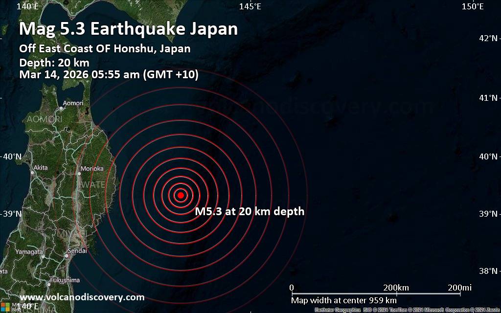 An earthquake of magnitude 5.3 occurred early morning on Saturday, March 14th, 2026, at 5:55 am local time near Yamada, Shimohei-gun, Iwate, Japan, as reported by the European-Mediterranean Seismological Centre (EMSC).
According to preliminary data, the quake was located at a shallow depth of 20. km. Shallow earthquakes are felt more strongly than deeper ones as they are closer to the surface. The exact magnitude, epicenter, and depth of the quake might be revised within the next few hours or minutes as seismologists review data and refine their calculations, or as other agencies issue their report.
Our monitoring service identified a second report from Indonesia's Meteorology, Climatology, and Geophysical Agency which listed the quake at magnitude 5.3 as well. Other agencies reporting the same quake include France's Réseau National de Surveillance Sismique (RéNaSS) at magnitude 5.3, the citizen-seismograph network of RaspberryShake at magnitude 5.3, and the German Research Centre for Geosciences (GFZ) at magnitude 5.3.
Generally quakes of this magnitude are recorded by more than one agency and the results can vary, with subsequent reports that come in after the first one often showing more accuracy.
Based on the preliminary seismic data, the quake should not have caused any significant damage, but was probably felt by many people as light vibration in the area of the epicenter.
Weak shaking might have been felt in Yamada (pop. 15,200) located 128 km from the epicenter.
VolcanoDiscovery will automatically update magnitude and depth if these change and follow up if other significant news about the quake become available. If you’re in the area, please send us your experience through our reporting mechanism, either online or via our mobile app. This will help us provide more first-hand updates to anyone around the globe who wants to know more about this quake.
Earthquake data: Date & time: Mar 14, 2026 05:55 am (GMT +10) local time (13 Mar 2026 19:55 GMT)Magnitude: 5.3 Depth: 20.00 km Epicenter latitude / longitude: 39.32°N / 143.43°E  ( Japan) Primary data source: EMSChttps://www.volcanodiscovery.com/earthquake/news/297564/Significant-earthquake-of-magnitude-53-just-reported-128-km-east-of-Yamada-Japan.html
0
20
Read More
|
World Earthquake Report for March 2026
Webmaster
Yesterday at 07:00 PM
World Earthquake Report for March 2026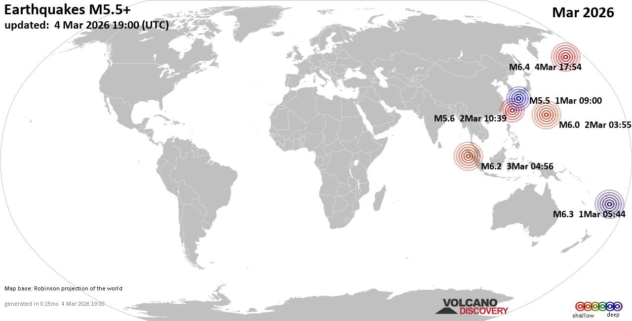 Worldwide earthquakes above magnitude 5.5 during March 2026 Magnitude 9+: none Magnitude 8+: none Magnitude 7+: none Magnitude 6+: 7 earthquakes Magnitude 5+: 77 earthquakes Magnitude 4+: 577 earthquakes Magnitude 3+: 2248 earthquakes Magnitude 2+: 5052 earthquakes No quakes of magnitude 7 or higher List of 10 largest earthquakes in the world during March 2026:Wednesday, Mar 4, 2026, at 07:54 am (GMT -10) - Sunday, Mar 1, 2026, at 06:44 pm (GMT +13) - Tuesday, Mar 3, 2026, at 11:56 am (Pontianak time) - Monday, Mar 2, 2026, at 01:55 pm (GMT +10) - Monday, Mar 2, 2026, at 07:39 pm (GMT +9) - Sunday, Mar 1, 2026, at 06:00 pm (GMT +9) - Earthquake stats:   https://www.volcanodiscovery.com/view_news/296458/World-Earthquake-Report-for-March-2026.html https://www.volcanodiscovery.com/view_news/296458/World-Earthquake-Report-for-March-2026.html
0
10
Read More
|
Significant magnitude 6.2 quake hits 69 km west of Vallenar, Chile in the morning
Webmaster
Yesterday at 01:49 PM
Significant magnitude 6.2 quake hits 69 km west of Vallenar, Chile in the morning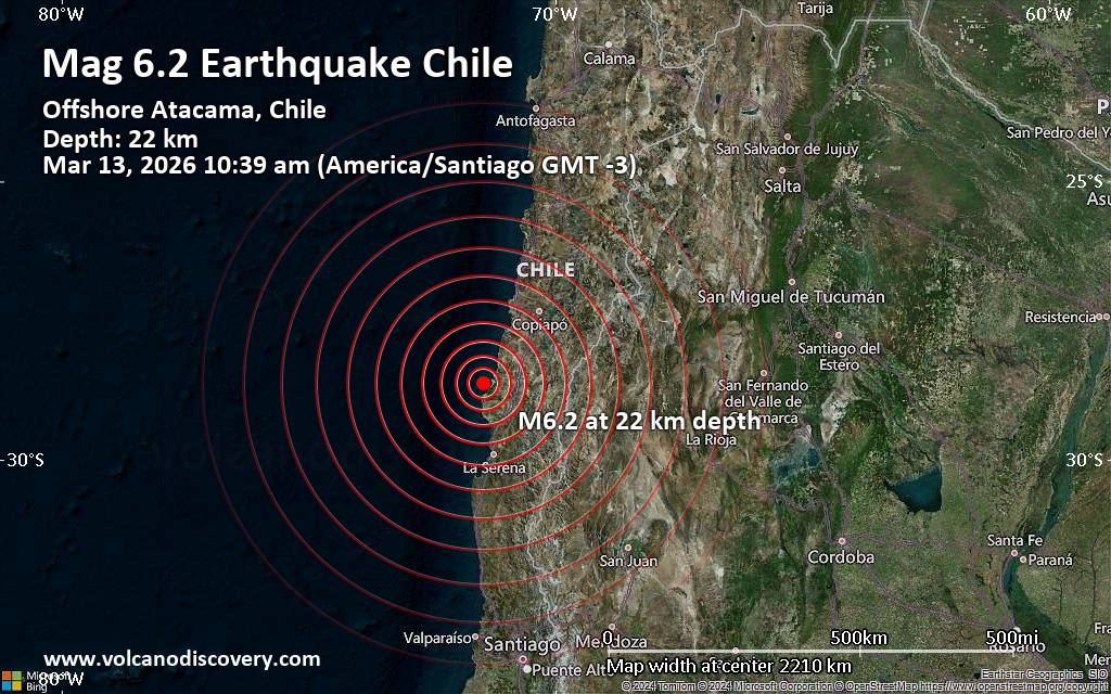 An earthquake of magnitude 6.2 occurred in the morning on Friday, March 13th, 2026, at 10:39 am local time near Vallenar, Provincia de Huasco, Region de Atacama, Chile, as reported by the European-Mediterranean Seismological Centre (EMSC).
According to preliminary data, the quake was located at a shallow depth of 22. km. Shallow earthquakes are felt more strongly than deeper ones as they are closer to the surface. The exact magnitude, epicenter, and depth of the quake might be revised within the next few hours or minutes as seismologists review data and refine their calculations, or as other agencies issue their report.
Our monitoring service identified a second report from the citizen-seismograph network of RaspberryShake which listed the quake at magnitude 6.2 as well. Other agencies reporting the same quake include The National Seismological Center (Centro Sismológico Nacional, CSN) of the University of Chile at magnitude 6.3, and the German Research Centre for Geosciences (GFZ) at magnitude 6.4.
Generally quakes of this magnitude are recorded by more than one agency and the results can vary, with subsequent reports that come in after the first one often showing more accuracy.
Based on the preliminary seismic data, the quake should have been widely felt by almost everyone in the area of the epicenter. It might have caused light to moderate damage.
Moderate shaking probably occurred in Huasco (pop. 9,000) located 31 km from the epicenter, and Freirina (pop. 6,000) 40 km away.
In Vallenar (pop. 44,900) located 69 km from the epicenter, Alto del Carmen (pop. 5,000) 95 km away, La Serena (pop. 154,500) 141 km away, and Coquimbo (pop. 161,300) 145 km away, the quake should have been felt as light shaking.
VolcanoDiscovery will automatically update magnitude and depth if these change and follow up if other significant news about the quake become available. If you’re in the area, please send us your experience through our reporting mechanism, either online or via our mobile app. This will help us provide more first-hand updates to anyone around the globe who wants to know more about this quake.
Earthquake data: Date & time: Mar 13, 2026 10:39 am (Santiago time) local time (13 Mar 2026 13:39 GMT)Magnitude: 6.2 Depth: 22.00 km Epicenter latitude / longitude: 28.65°S / 71.46°W  ( Region de Atacama, Chile) Primary data source: EMSChttps://www.volcanodiscovery.com/earthquake/news/297550/Significant-magnitude-62-quake-hits-69-km-west-of-Vallenar-Chile-in-the-morning-.html
0
55
Read More
|
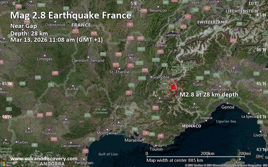
Small earthquake of magnitude 2.8 just reported 1 km southeast of Briancon, France
Webmaster
Yesterday at 10:16 AM
Small earthquake of magnitude 2.8 just reported 1 km southeast of Briancon, FranceJust 7 minutes ago, a 2.8-magnitude earthquake struck near Briancon, Hautes-Alpes, Provence-Alpes-Cote d'Azur, France. The tremor was recorded in the morning on Friday, March 13th, 2026, at 11:08 am local time, at a shallow depth of 27.58 km below the surface.
The event was filed by France's Réseau National de Surveillance Sismique (RéNaSS), the first seismological agency to report it.
According to preliminary calculations, we do not expect that the quake was felt by many people and did not cause any damage. In Briancon (pop. 11,600, 1 km away), Villar-Saint-Pancrace (pop. 1,500, 3 km away), Saint-Chaffrey (pop. 1,700, 5 km away), Villeneuve (pop. 3,400, 9 km away), Saint-Martin-de-Queyrieres (pop. 1000, 9 km away), Guillestre (pop. 2,400, 26 km away), Embrun (pop. 7,100, 38 km away), and Gap (pop. 42,700, 58 km away), the quake was probably not felt.
Earthquake data: Date & time: Mar 13, 2026 11:08 am (GMT +1) local time (13 Mar 2026 10:08 GMT)Magnitude: 2.8 Depth: 27.58 km Epicenter latitude / longitude: 44.89°N / 6.65°E  ( Hautes-Alpes, Provence-Alpes-Cote d'Azur, France) Primary data source: RENASShttps://www.volcanodiscovery.com/earthquake/news/297510/Small-earthquake-of-magnitude-28-just-reported-1-km-southeast-of-Briancon-France.html
0
135
Read More
|
Sunday: Light Rain Showers, Minimum Temperature: 4°C (39°F) Maximum Temperature: 10°C (50°F)
Webmaster
Yesterday at 08:00 AM
Maximum Temperature: 10°C (50°F), Minimum Temperature: 4°C (39°F), Wind Direction: southerly, Wind Speed: 11mph, Visibility: Moderate, Pressure: 1005mb, Humidity: 82%, UV Risk: 1, Pollution: Low, Sunrise: 06:25 GMT, Sunset: 18:12 GMT Source: Sunday: Light Rain Showers, Minimum Temperature: 4°C (39°F) Maximum Temperature: 10°C (50°F)
0
28
Read More
|
Saturday: Sunny Intervals, Minimum Temperature: 3°C (38°F) Maximum Temperature: 10°C (49°F)
Webmaster
Yesterday at 08:00 AM
Maximum Temperature: 10°C (49°F), Minimum Temperature: 3°C (38°F), Wind Direction: westerly, Wind Speed: 7mph, Visibility: Good, Pressure: 1005mb, Humidity: 71%, UV Risk: 3, Pollution: Low, Sunrise: 06:27 GMT, Sunset: 18:11 GMT Source: Saturday: Sunny Intervals, Minimum Temperature: 3°C (38°F) Maximum Temperature: 10°C (49°F)
0
32
Read More
|
Today: Light Rain Showers, Minimum Temperature: 1°C (34°F) Maximum Temperature: 8°C (46°F)
Webmaster
Yesterday at 08:00 AM
Maximum Temperature: 8°C (46°F), Minimum Temperature: 1°C (34°F), Wind Direction: south-westerly, Wind Speed: 13mph, Visibility: Moderate, Pressure: 996mb, Humidity: 68%, UV Risk: 1, Pollution: Low, Sunrise: 06:29 GMT, Sunset: 18:09 GMT Source: Today: Light Rain Showers, Minimum Temperature: 1°C (34°F) Maximum Temperature: 8°C (46°F)
0
31
Read More
|
Small magnitude 2.9 quake hits 23 miles southeast of Katanning, Western Australia, Australia around noon
Webmaster
Yesterday at 05:34 AM
Small magnitude 2.9 quake hits 23 miles southeast of Katanning, Western Australia, Australia around noon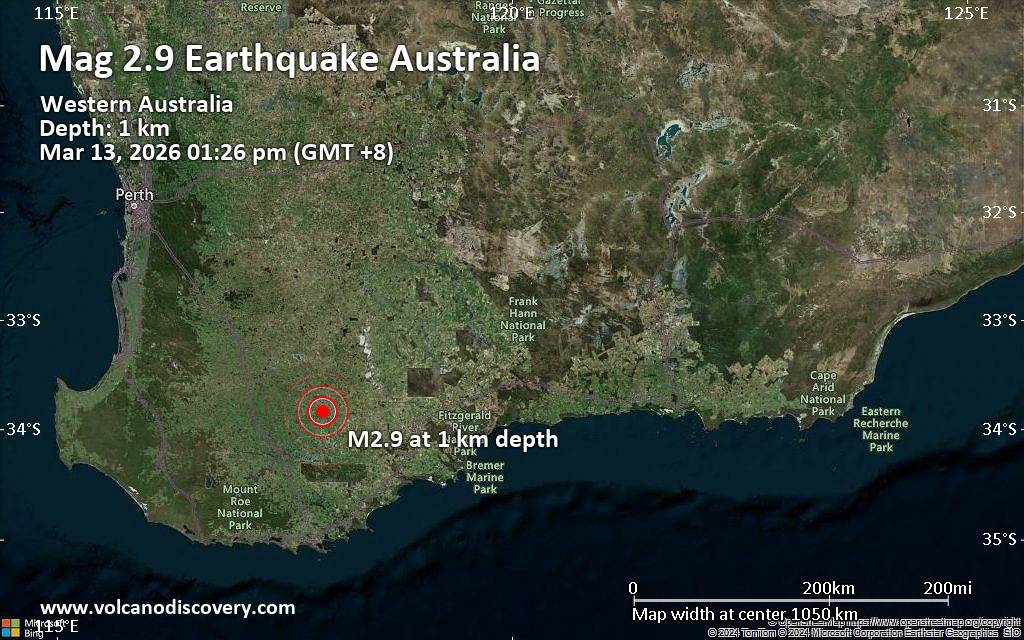 An earthquake of magnitude 2.9 occurred around noon on Friday, March 13th, 2026, at 1:26 pm local time near Katanning, Western Australia, Australia, as reported by the European-Mediterranean Seismological Centre (EMSC).
According to preliminary data, the quake was located at a very shallow depth of 0.4 miles. Shallow earthquakes are felt more strongly than deeper ones as they are closer to the surface. The exact magnitude, epicenter, and depth of the quake might be revised within the next few hours or minutes as seismologists review data and refine their calculations, or as other agencies issue their report.
Towns or cities near the epicenter where the quake might have been felt as very weak shaking include Pallinup (pop. 78) located 5 miles from the epicenter, Gnowangerup (pop. 590) 9 miles away, and Jackitup (pop. 60) 11 miles away. In Broomehill (pop. 380, 16 miles away), Tambellup (pop. 370, 21 miles away), Katanning (pop. 3,700, 23 miles away), Nyabing (pop. 290, 25 miles away), and Kojonup (pop. 1,200, 43 miles away), the quake was probably not felt.
Earthquake data: Date & time: 2026-03-13 13:26 local time (13 Mar 2026 05:26 GMT)Magnitude: 2.8 Depth: 0.74 km Epicenter latitude / longitude: 33.84°S / 117.91°E  ( Gnowangerup, Australia) Primary data source: GeoAuhttps://www.volcanodiscovery.com/earthquake/news/297500/Small-magnitude-29-quake-hits-23-miles-southeast-of-Katanning-Western-Australia-Australia-around-noo.html
0
55
Read More
|
|
Forums60
Topics765,641
Posts800,393
Members2,958
| |
Most Online17,963
Jan 15th, 2026
|
|
|
|
|
Copyright 1996 - 2026 by David Cottle. Designed by David Bate Jr. All Rights Reserved.
By using this forum, the user agrees not to transfer any data or technical information received under the agreement, to any other entity without the express approval of the AUS-CITY Forum Admins and/or authors of individual posts (Forum Admins and DoD/USSPACECOM for the analysis of satellite tracking data).
Two-line elements (TLE) and all other satellite data presented and distributed via this forum and e-mail lists of AUS-CITY are distributed with permission from DoD/USSTRATCOM.


Reprise Hosting

|

|


 - Click image for larger picture.")


