|
|
|
0 members (),
2,345
guests, and
20
robots. |
|
Key:
Admin,
Global Mod,
Mod
|
|
S |
M |
T |
W |
T |
F |
S |
|
|
|
|
1
|
2
|
3
|
4
|
|
5
|
6
|
7
|
8
|
9
|
10
|
11
|
|
12
|
13
|
14
|
15
|
16
|
17
|
18
|
|
19
|
20
|
21
|
22
|
23
|
24
|
25
|
|
26
|
27
|
28
|
29
|
30
|
|
|
|
There are no members with birthdays on this day. |
 SPC MD 540
Webmaster
20 minutes ago
SPC MD 540
Webmaster
20 minutes ago
SPC MD 540MD 0540 CONCERNING SEVERE POTENTIAL...SEVERE THUNDERSTORM WATCH LIKELY FOR NORTHEASTERN TEXAS...SOUTHWESTERN ARKANSAS...NORTHWESTERN LOUISIANA 
Mesoscale Discussion 0540
NWS Storm Prediction Center Norman OK
0946 PM CDT Sat Apr 25 2026

Areas affected...northeastern Texas...southwestern
Arkansas...northwestern Louisiana

Concerning...Severe potential...Severe Thunderstorm Watch likely

Valid 260246Z - 260445Z

Probability of Watch Issuance...80 percent

SUMMARY...Thunderstorm activity will continue downstream of WW144
and WW146.

DISCUSSION...Supercells continue across portions of western
Arkansas, with hints of additional development near the boundary
across eastern Oklahoma into southeastern Arkansas. The environment
downstream in northeastern Texas/southern Arkansas/northwestern
Louisiana remains very unstable and strongly sheared. This will
favor maintenance of ongoing storms and potential for new supercell
development. Nocturnal low-level cooling and capping appears to be
increasing, which will likely keep the main threat for large hail.
However, given some remaining low-level shear any surface based
storm would have potential for a tornado. A new watch will likely be
needed to cover these threats by 04z.

..Thornton.. 04/26/2026

...Please see www.spc.noaa.gov for graphic product...

ATTN...WFO...JAN...LZK...SHV...FWD...

LAT...LON   33079212 33869259 34029331 34039420 33709508 33589531
            32959575 32559528 32199385 32089298 32069233 32379221
            33079212

MOST PROBABLE PEAK TORNADO INTENSITY...100-125 MPH
MOST PROBABLE PEAK WIND GUST...55-70 MPH
MOST PROBABLE PEAK HAIL SIZE...2.00-3.50 IN
Read morehttps://www.spc.noaa.gov/products/md/md0540.html
0
Read More
|
SPC MD 540
Webmaster
20 minutes ago
SPC MD 540MD 0540 CONCERNING SEVERE POTENTIAL...SEVERE THUNDERSTORM WATCH LIKELY FOR NORTHEASTERN TEXAS...SOUTHWESTERN ARKANSAS...NORTHWESTERN LOUISIANA
Mesoscale Discussion 0540
NWS Storm Prediction Center Norman OK
0946 PM CDT Sat Apr 25 2026

Areas affected...northeastern Texas...southwestern
Arkansas...northwestern Louisiana

Concerning...Severe potential...Severe Thunderstorm Watch likely

Valid 260246Z - 260445Z

Probability of Watch Issuance...80 percent

SUMMARY...Thunderstorm activity will continue downstream of WW144
and WW146.

DISCUSSION...Supercells continue across portions of western
Arkansas, with hints of additional development near the boundary
across eastern Oklahoma into southeastern Arkansas. The environment
downstream in northeastern Texas/southern Arkansas/northwestern
Louisiana remains very unstable and strongly sheared. This will
favor maintenance of ongoing storms and potential for new supercell
development. Nocturnal low-level cooling and capping appears to be
increasing, which will likely keep the main threat for large hail.
However, given some remaining low-level shear any surface based
storm would have potential for a tornado. A new watch will likely be
needed to cover these threats by 04z.

..Thornton.. 04/26/2026

...Please see www.spc.noaa.gov for graphic product...

ATTN...WFO...JAN...LZK...SHV...FWD...

LAT...LON   33079212 33869259 34029331 34039420 33709508 33589531
            32959575 32559528 32199385 32089298 32069233 32379221
            33079212

MOST PROBABLE PEAK TORNADO INTENSITY...100-125 MPH
MOST PROBABLE PEAK WIND GUST...55-70 MPH
MOST PROBABLE PEAK HAIL SIZE...2.00-3.50 IN
Read morehttps://www.spc.noaa.gov/products/md/md0540.html
0
Read More
|
SPC MD 541
Webmaster
20 minutes ago
SPC MD 541MD 0541 CONCERNING SEVERE POTENTIAL...TORNADO WATCH LIKELY FOR NORTH-CENTRAL TEXAS 
Mesoscale Discussion 0541
NWS Storm Prediction Center Norman OK
1031 PM CDT Sat Apr 25 2026

Areas affected...north-central Texas

Concerning...Severe potential...Tornado Watch likely

Valid 260331Z - 260500Z

Probability of Watch Issuance...95 percent

SUMMARY...A mature supercell continues to track southward in WW144.
A new watch will likely be needed soon.

DISCUSSION...A mature supercell with a history of tornadoes and hail
up to baseball size continues to track southeast near the Ft. Worth
area. This supercell will likely continue given the favorable very
unstable and highly sheared environment across central/eastern
Texas. VAD profiles from KFWS show 0-1km SRH around 350 m2/s2 with
large clock-wise curvature in the low levels. The threat for large
to very large hail and tornadoes will continue with this storm. A
new watch will likely be needed to replace portions of WW144 and
extend further south.

..Thornton/Leitman.. 04/26/2026

...Please see www.spc.noaa.gov for graphic product...

ATTN...WFO...SHV...FWD...

LAT...LON   31999695 32159743 32509787 33029795 33089789 33289747
            33379701 33419639 33359572 33179536 32759529 32169546
            31999612 31909664 31999695

MOST PROBABLE PEAK TORNADO INTENSITY...120-145 MPH
MOST PROBABLE PEAK WIND GUST...55-70 MPH
MOST PROBABLE PEAK HAIL SIZE...2.75-4.25 IN
Read morehttps://www.spc.noaa.gov/products/md/md0541.html
0
Read More
|
SPC MD 541
Webmaster
20 minutes ago
SPC MD 541MD 0541 CONCERNING SEVERE POTENTIAL...TORNADO WATCH LIKELY FOR NORTH-CENTRAL TEXAS
Mesoscale Discussion 0541
NWS Storm Prediction Center Norman OK
1031 PM CDT Sat Apr 25 2026

Areas affected...north-central Texas

Concerning...Severe potential...Tornado Watch likely

Valid 260331Z - 260500Z

Probability of Watch Issuance...95 percent

SUMMARY...A mature supercell continues to track southward in WW144.
A new watch will likely be needed soon.

DISCUSSION...A mature supercell with a history of tornadoes and hail
up to baseball size continues to track southeast near the Ft. Worth
area. This supercell will likely continue given the favorable very
unstable and highly sheared environment across central/eastern
Texas. VAD profiles from KFWS show 0-1km SRH around 350 m2/s2 with
large clock-wise curvature in the low levels. The threat for large
to very large hail and tornadoes will continue with this storm. A
new watch will likely be needed to replace portions of WW144 and
extend further south.

..Thornton/Leitman.. 04/26/2026

...Please see www.spc.noaa.gov for graphic product...

ATTN...WFO...SHV...FWD...

LAT...LON   31999695 32159743 32509787 33029795 33089789 33289747
            33379701 33419639 33359572 33179536 32759529 32169546
            31999612 31909664 31999695

MOST PROBABLE PEAK TORNADO INTENSITY...120-145 MPH
MOST PROBABLE PEAK WIND GUST...55-70 MPH
MOST PROBABLE PEAK HAIL SIZE...2.75-4.25 IN
Read morehttps://www.spc.noaa.gov/products/md/md0541.html
0
Read More
|
SPC Tornado Watch 148
Webmaster
25 minutes ago
SPC Tornado Watch 148WW 148 TORNADO TX 260340Z - 261000Z 
URGENT - IMMEDIATE BROADCAST REQUESTED
Tornado Watch Number 148
NWS Storm Prediction Center Norman OK
1040 PM CDT Sat Apr 25 2026

The NWS Storm Prediction Center has issued a

* Tornado Watch for portions of
  North Texas

* Effective this Saturday night and Sunday morning from 1040 PM
  until 500 AM CDT.

* Primary threats include...
  A few tornadoes and a couple intense tornadoes possible
  Scattered large hail and isolated very large hail events to 3
    inches in diameter likely
  Scattered damaging wind gusts to 70 mph possible

SUMMARY...Isolated to scattered supercells will continue
east/southeast across North Texas the next several hours. The
environment across North Texas remains favorable for strong
tornadoes. Additionally, very large hail has occurred with these
storms and potential for 2+ inch hail with continue into the
overnight period.

The tornado watch area is approximately along and 60 statute miles
east and west of a line from 15 miles east of Sherman TX to 50 miles
south southeast of Dallas TX. For a complete depiction of the watch
see the associated watch outline update (WOUS64 KWNS WOU8).

PRECAUTIONARY/PREPAREDNESS ACTIONS...

REMEMBER...A Tornado Watch means conditions are favorable for
tornadoes and severe thunderstorms in and close to the watch
area. Persons in these areas should be on the lookout for
threatening weather conditions and listen for later statements
and possible warnings.

&&

OTHER WATCH INFORMATION...CONTINUE...WW 144...WW 145...WW 147...

AVIATION...Tornadoes and a few severe thunderstorms with hail
surface and aloft to 3 inches. Extreme turbulence and surface wind
gusts to 60 knots. A few cumulonimbi with maximum tops to 500. Mean
storm motion vector 28035.

...Leitman
Read morehttps://www.spc.noaa.gov/products/watch/ww0148.html
0
Read More
|
SPC Tornado Watch 148
Webmaster
25 minutes ago
SPC Tornado Watch 148WW 148 TORNADO TX 260340Z - 261000Z
URGENT - IMMEDIATE BROADCAST REQUESTED
Tornado Watch Number 148
NWS Storm Prediction Center Norman OK
1040 PM CDT Sat Apr 25 2026

The NWS Storm Prediction Center has issued a

* Tornado Watch for portions of
  North Texas

* Effective this Saturday night and Sunday morning from 1040 PM
  until 500 AM CDT.

* Primary threats include...
  A few tornadoes and a couple intense tornadoes possible
  Scattered large hail and isolated very large hail events to 3
    inches in diameter likely
  Scattered damaging wind gusts to 70 mph possible

SUMMARY...Isolated to scattered supercells will continue
east/southeast across North Texas the next several hours. The
environment across North Texas remains favorable for strong
tornadoes. Additionally, very large hail has occurred with these
storms and potential for 2+ inch hail with continue into the
overnight period.

The tornado watch area is approximately along and 60 statute miles
east and west of a line from 15 miles east of Sherman TX to 50 miles
south southeast of Dallas TX. For a complete depiction of the watch
see the associated watch outline update (WOUS64 KWNS WOU8).

PRECAUTIONARY/PREPAREDNESS ACTIONS...

REMEMBER...A Tornado Watch means conditions are favorable for
tornadoes and severe thunderstorms in and close to the watch
area. Persons in these areas should be on the lookout for
threatening weather conditions and listen for later statements
and possible warnings.

&&

OTHER WATCH INFORMATION...CONTINUE...WW 144...WW 145...WW 147...

AVIATION...Tornadoes and a few severe thunderstorms with hail
surface and aloft to 3 inches. Extreme turbulence and surface wind
gusts to 60 knots. A few cumulonimbi with maximum tops to 500. Mean
storm motion vector 28035.

...Leitman
Read morehttps://www.spc.noaa.gov/products/watch/ww0148.html
0
Read More
|
SPC Severe Thunderstorm Watch 145 Status Reports
Webmaster
31 minutes ago
SPC Severe Thunderstorm Watch 145 Status ReportsWW 0145 Status Updates 
STATUS REPORT ON WW 145

SEVERE WEATHER THREAT CONTINUES RIGHT OF A LINE FROM 25 N MLC TO
15 NW HRO.

..THORNTON..04/26/26

ATTN...WFO...TSA...ICT...SGF...


STATUS REPORT FOR WS 145

SEVERE WEATHER THREAT CONTINUES FOR THE FOLLOWING AREAS

ARC033-047-087-131-143-260440-

AR
.    ARKANSAS COUNTIES INCLUDED ARE

CRAWFORD             FRANKLIN            MADISON
SEBASTIAN            WASHINGTON


OKC023-079-127-135-260440-

OK
.    OKLAHOMA COUNTIES INCLUDED ARE

CHOCTAW              LE FLORE            PUSHMATAHA
SEQUOYAH


THE WATCH STATUS MESSAGE IS FOR GUIDANCE PURPOSES ONLY.  PLEASE
REFER TO WATCH COUNTY NOTIFICATION STATEMENTS FOR OFFICIAL
INFORMATION ON COUNTIES...INDEPENDENT CITIES AND MARINE ZONES
CLEARED FROM SEVERE THUNDERSTORM AND TORNADO WATCHES.
Read morehttps://www.spc.noaa.gov/products/watch/ws0145.html
0
Read More
|
SPC Severe Thunderstorm Watch 145 Status Reports
Webmaster
31 minutes ago
SPC Severe Thunderstorm Watch 145 Status ReportsWW 0145 Status Updates
STATUS REPORT ON WW 145

SEVERE WEATHER THREAT CONTINUES RIGHT OF A LINE FROM 25 N MLC TO
15 NW HRO.

..THORNTON..04/26/26

ATTN...WFO...TSA...ICT...SGF...


STATUS REPORT FOR WS 145

SEVERE WEATHER THREAT CONTINUES FOR THE FOLLOWING AREAS

ARC033-047-087-131-143-260440-

AR
.    ARKANSAS COUNTIES INCLUDED ARE

CRAWFORD             FRANKLIN            MADISON
SEBASTIAN            WASHINGTON


OKC023-079-127-135-260440-

OK
.    OKLAHOMA COUNTIES INCLUDED ARE

CHOCTAW              LE FLORE            PUSHMATAHA
SEQUOYAH


THE WATCH STATUS MESSAGE IS FOR GUIDANCE PURPOSES ONLY.  PLEASE
REFER TO WATCH COUNTY NOTIFICATION STATEMENTS FOR OFFICIAL
INFORMATION ON COUNTIES...INDEPENDENT CITIES AND MARINE ZONES
CLEARED FROM SEVERE THUNDERSTORM AND TORNADO WATCHES.
Read morehttps://www.spc.noaa.gov/products/watch/ws0145.html
0
Read More
|
SPC Severe Thunderstorm Watch 145
Webmaster
31 minutes ago
SPC Severe Thunderstorm Watch 145WW 145 SEVERE TSTM AR KS MO OK 252225Z - 260500Z
URGENT - IMMEDIATE BROADCAST REQUESTED
Severe Thunderstorm Watch Number 145
NWS Storm Prediction Center Norman OK
525 PM CDT Sat Apr 25 2026

The NWS Storm Prediction Center has issued a

* Severe Thunderstorm Watch for portions of
  Northwest Arkansas
  Southeast Kansas
  Southwest Missouri
  Northeast Oklahoma

* Effective this Saturday afternoon from 525 PM until Midnight
  CDT.

* Primary threats include...
  Scattered large hail likely with isolated very large hail events
    to 2 inches in diameter possible
  Scattered damaging wind gusts to 70 mph possible
  A tornado or two possible

SUMMARY...Scattered thunderstorms will develop east/northeast
through the evening. These storms will mainly pose a risk for large
hail in the 1.0-2.0 inch range. A few strong to severe wind gusts
also are possible. While the overall tornado risk is low, a surface
boundary across west-central Arkansas could lift northward this
evening and a tornado along this boundary is conditionally possible.

The severe thunderstorm watch area is approximately along and 60
statute miles north and south of a line from 40 miles west southwest
of Bartlesville OK to 35 miles north northeast of Fayetteville AR.
For a complete depiction of the watch see the associated watch
outline update (WOUS64 KWNS WOU5).

PRECAUTIONARY/PREPAREDNESS ACTIONS...

REMEMBER...A Severe Thunderstorm Watch means conditions are
favorable for severe thunderstorms in and close to the watch area.
Persons in these areas should be on the lookout for threatening
weather conditions and listen for later statements and possible
warnings. Severe thunderstorms can and occasionally do produce
tornadoes.

&&

OTHER WATCH INFORMATION...CONTINUE...WW 143...WW 144...

AVIATION...A few severe thunderstorms with hail surface and aloft to
2 inches. Extreme turbulence and surface wind gusts to 60 knots. A
few cumulonimbi with maximum tops to 500. Mean storm motion vector
27035.

...Leitman
Read morehttps://www.spc.noaa.gov/products/watch/ww0145.html
0
Read More
|
SPC Tornado Watch 146 Status Reports
Webmaster
32 minutes ago
SPC Tornado Watch 146 Status ReportsWW 0146 Status Updates 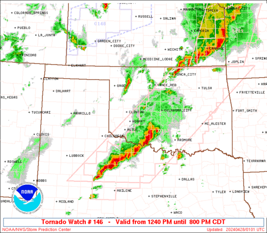
STATUS REPORT ON WW 146

THE SEVERE WEATHER THREAT CONTINUES ACROSS THE ENTIRE WATCH AREA.

..THORNTON..04/26/26

ATTN...WFO...LZK...SHV...


STATUS REPORT FOR WT 146

SEVERE WEATHER THREAT CONTINUES FOR THE FOLLOWING AREAS

ARC019-051-057-059-061-081-083-097-099-103-105-109-113-127-133-
149-260440-

AR
.    ARKANSAS COUNTIES INCLUDED ARE

CLARK                GARLAND             HEMPSTEAD
HOT SPRING           HOWARD              LITTLE RIVER
LOGAN                MONTGOMERY          NEVADA
OUACHITA             PERRY               PIKE
POLK                 SCOTT               SEVIER
YELL


THE WATCH STATUS MESSAGE IS FOR GUIDANCE PURPOSES ONLY.  PLEASE
REFER TO WATCH COUNTY NOTIFICATION STATEMENTS FOR OFFICIAL
INFORMATION ON COUNTIES...INDEPENDENT CITIES AND MARINE ZONES
CLEARED FROM SEVERE THUNDERSTORM AND TORNADO WATCHES.
Read morehttps://www.spc.noaa.gov/products/watch/ws0146.html
0
Read More
|
SPC Tornado Watch 146 Status Reports
Webmaster
32 minutes ago
SPC Tornado Watch 146 Status ReportsWW 0146 Status Updates
STATUS REPORT ON WW 146

THE SEVERE WEATHER THREAT CONTINUES ACROSS THE ENTIRE WATCH AREA.

..THORNTON..04/26/26

ATTN...WFO...LZK...SHV...


STATUS REPORT FOR WT 146

SEVERE WEATHER THREAT CONTINUES FOR THE FOLLOWING AREAS

ARC019-051-057-059-061-081-083-097-099-103-105-109-113-127-133-
149-260440-

AR
.    ARKANSAS COUNTIES INCLUDED ARE

CLARK                GARLAND             HEMPSTEAD
HOT SPRING           HOWARD              LITTLE RIVER
LOGAN                MONTGOMERY          NEVADA
OUACHITA             PERRY               PIKE
POLK                 SCOTT               SEVIER
YELL


THE WATCH STATUS MESSAGE IS FOR GUIDANCE PURPOSES ONLY.  PLEASE
REFER TO WATCH COUNTY NOTIFICATION STATEMENTS FOR OFFICIAL
INFORMATION ON COUNTIES...INDEPENDENT CITIES AND MARINE ZONES
CLEARED FROM SEVERE THUNDERSTORM AND TORNADO WATCHES.
Read morehttps://www.spc.noaa.gov/products/watch/ws0146.html
0
Read More
|
SPC Severe Thunderstorm Watch 147
Webmaster
56 minutes ago
SPC Severe Thunderstorm Watch 147WW 147 SEVERE TSTM AR LA OK TX 260310Z - 261100Z 
URGENT - IMMEDIATE BROADCAST REQUESTED
Severe Thunderstorm Watch Number 147
NWS Storm Prediction Center Norman OK
1010 PM CDT Sat Apr 25 2026

The NWS Storm Prediction Center has issued a

* Severe Thunderstorm Watch for portions of
  Southwest Arkansas
  Northwest Louisiana
  Southeast Oklahoma
  Northeast Texas

* Effective this Saturday night and Sunday morning from 1010 PM
  until 600 AM CDT.

* Primary threats include...
  Scattered large hail likely with isolated very large hail events
    to 2 inches in diameter possible
  Scattered damaging wind gusts to 70 mph possible
  A tornado or two possible

SUMMARY...Isolated to scattered thunderstorms will continue to track
southeast into the overnight hours. Nocturnal cooling and increasing
boundary-layer inhibition will limit surface-based storms and large
hail up to 2 inch diameter will be the main hazard. Isolated severe
gusts also are possible. If a storm can become surface-based, a
tornado is also possible.

The severe thunderstorm watch area is approximately along and 65
statute miles north and south of a line from 60 miles southwest of
De Queen AR to 35 miles east of El Dorado AR. For a complete
depiction of the watch see the associated watch outline update
(WOUS64 KWNS WOU7).

PRECAUTIONARY/PREPAREDNESS ACTIONS...

REMEMBER...A Severe Thunderstorm Watch means conditions are
favorable for severe thunderstorms in and close to the watch area.
Persons in these areas should be on the lookout for threatening
weather conditions and listen for later statements and possible
warnings. Severe thunderstorms can and occasionally do produce
tornadoes.

&&

OTHER WATCH INFORMATION...CONTINUE...WW 144...WW 145...WW 146...

AVIATION...A few severe thunderstorms with hail surface and aloft to
2 inches. Extreme turbulence and surface wind gusts to 60 knots. A
few cumulonimbi with maximum tops to 500. Mean storm motion vector
29035.

...Leitman
Read morehttps://www.spc.noaa.gov/products/watch/ww0147.html
0
Read More
|
SPC Severe Thunderstorm Watch 147
Webmaster
56 minutes ago
SPC Severe Thunderstorm Watch 147WW 147 SEVERE TSTM AR LA OK TX 260310Z - 261100Z
URGENT - IMMEDIATE BROADCAST REQUESTED
Severe Thunderstorm Watch Number 147
NWS Storm Prediction Center Norman OK
1010 PM CDT Sat Apr 25 2026

The NWS Storm Prediction Center has issued a

* Severe Thunderstorm Watch for portions of
  Southwest Arkansas
  Northwest Louisiana
  Southeast Oklahoma
  Northeast Texas

* Effective this Saturday night and Sunday morning from 1010 PM
  until 600 AM CDT.

* Primary threats include...
  Scattered large hail likely with isolated very large hail events
    to 2 inches in diameter possible
  Scattered damaging wind gusts to 70 mph possible
  A tornado or two possible

SUMMARY...Isolated to scattered thunderstorms will continue to track
southeast into the overnight hours. Nocturnal cooling and increasing
boundary-layer inhibition will limit surface-based storms and large
hail up to 2 inch diameter will be the main hazard. Isolated severe
gusts also are possible. If a storm can become surface-based, a
tornado is also possible.

The severe thunderstorm watch area is approximately along and 65
statute miles north and south of a line from 60 miles southwest of
De Queen AR to 35 miles east of El Dorado AR. For a complete
depiction of the watch see the associated watch outline update
(WOUS64 KWNS WOU7).

PRECAUTIONARY/PREPAREDNESS ACTIONS...

REMEMBER...A Severe Thunderstorm Watch means conditions are
favorable for severe thunderstorms in and close to the watch area.
Persons in these areas should be on the lookout for threatening
weather conditions and listen for later statements and possible
warnings. Severe thunderstorms can and occasionally do produce
tornadoes.

&&

OTHER WATCH INFORMATION...CONTINUE...WW 144...WW 145...WW 146...

AVIATION...A few severe thunderstorms with hail surface and aloft to
2 inches. Extreme turbulence and surface wind gusts to 60 knots. A
few cumulonimbi with maximum tops to 500. Mean storm motion vector
29035.

...Leitman
Read morehttps://www.spc.noaa.gov/products/watch/ww0147.html
0
Read More
|
Preity Zinta punches Arya, batter’s reaction goes viral – Watch
Webmaster
1 hour ago
Punjab Kings pulled off a record chase against Delhi Capitals, but a playful moment stole the show as Preity Zinta jokingly punched Priyansh Arya, whose reaction went viral. Ravi Shastri quipped, “Oh, that was a good punch.” Earlier, KL Rahul’s 152 powered DC to 264/2, but Punjab responded strongly, with Prabhsimran, Arya, and Shreyas Iyer leading a stunning chase to stay unbeaten. Source: Preity Zinta punches Arya, batter’s reaction goes viral - Watch
0
Read More
|
SPC Tornado Watch 144 Status Reports
Webmaster
1 hour ago
SPC Tornado Watch 144 Status ReportsWW 0144 Status Updates 
STATUS REPORT ON WW 144

SEVERE WEATHER THREAT CONTINUES RIGHT OF A LINE FROM 45 ENE ABI
TO 25 WNW MKO.

..THORNTON..04/26/26

ATTN...WFO...OUN...TSA...SHV...FWD...


STATUS REPORT FOR WT 144

SEVERE WEATHER THREAT CONTINUES FOR THE FOLLOWING AREAS

ARC033-131-260340-

AR
.    ARKANSAS COUNTIES INCLUDED ARE

CRAWFORD             SEBASTIAN


OKC005-013-019-023-029-037-061-069-077-079-085-089-091-095-099-
101-121-123-127-135-260340-

OK
.    OKLAHOMA COUNTIES INCLUDED ARE

ATOKA                BRYAN               CARTER
CHOCTAW              COAL                CREEK
HASKELL              JOHNSTON            LATIMER
LE FLORE             LOVE                MCCURTAIN
MCINTOSH             MARSHALL            MURRAY
MUSKOGEE             PITTSBURG           PONTOTOC
PUSHMATAHA           SEQUOYAH


TXC085-097-113-119-121-147-159-181-223-231-237-277-337-363-367-
387-397-439-449-497-260340-
Read morehttps://www.spc.noaa.gov/products/watch/ws0144.html
0
Read More
|
SPC Tornado Watch 144 Status Reports
Webmaster
1 hour ago
SPC Tornado Watch 144 Status ReportsWW 0144 Status Updates
STATUS REPORT ON WW 144

SEVERE WEATHER THREAT CONTINUES RIGHT OF A LINE FROM 45 ENE ABI
TO 25 WNW MKO.

..THORNTON..04/26/26

ATTN...WFO...OUN...TSA...SHV...FWD...


STATUS REPORT FOR WT 144

SEVERE WEATHER THREAT CONTINUES FOR THE FOLLOWING AREAS

ARC033-131-260340-

AR
.    ARKANSAS COUNTIES INCLUDED ARE

CRAWFORD             SEBASTIAN


OKC005-013-019-023-029-037-061-069-077-079-085-089-091-095-099-
101-121-123-127-135-260340-

OK
.    OKLAHOMA COUNTIES INCLUDED ARE

ATOKA                BRYAN               CARTER
CHOCTAW              COAL                CREEK
HASKELL              JOHNSTON            LATIMER
LE FLORE             LOVE                MCCURTAIN
MCINTOSH             MARSHALL            MURRAY
MUSKOGEE             PITTSBURG           PONTOTOC
PUSHMATAHA           SEQUOYAH


TXC085-097-113-119-121-147-159-181-223-231-237-277-337-363-367-
387-397-439-449-497-260340-
Read morehttps://www.spc.noaa.gov/products/watch/ws0144.html
0
Read More
|
SPC Tornado Watch 144
Webmaster
1 hour ago
SPC Tornado Watch 144WW 144 TORNADO OK TX 252050Z - 260400Z
URGENT - IMMEDIATE BROADCAST REQUESTED
Tornado Watch Number 144
NWS Storm Prediction Center Norman OK
350 PM CDT Sat Apr 25 2026

The NWS Storm Prediction Center has issued a

* Tornado Watch for portions of
  Southern and Central Oklahoma
  North Texas

* Effective this Saturday afternoon and evening from 350 PM until
  1100 PM CDT.

* Primary threats include...
  A few tornadoes likely with a couple intense tornadoes possible
  Widespread large hail and isolated very large hail events to 4
    inches in diameter likely
  Scattered damaging winds likely with isolated significant gusts
    to 80 mph possible

SUMMARY...Intense storm development is expected through late
afternoon and early evening, initially and especially across
south-central Oklahoma and far northern Texas. Robust supercells
capable of very large hail are expected, along with heightened
tornado potential, especially in vicinity of the warm front.
Damaging wind potential will also steadily increase later this
evening as storms progress east-southeastward across the region.

The tornado watch area is approximately along and 100 statute miles
north and south of a line from 20 miles northwest of Wichita Falls
TX to 65 miles northeast of Paris TX. For a complete depiction of
the watch see the associated watch outline update (WOUS64 KWNS
WOU4).

PRECAUTIONARY/PREPAREDNESS ACTIONS...

REMEMBER...A Tornado Watch means conditions are favorable for
tornadoes and severe thunderstorms in and close to the watch
area. Persons in these areas should be on the lookout for
threatening weather conditions and listen for later statements
and possible warnings.

&&

OTHER WATCH INFORMATION...CONTINUE...WW 143...

AVIATION...Tornadoes and a few severe thunderstorms with hail
surface and aloft to 4 inches. Extreme turbulence and surface wind
gusts to 70 knots. A few cumulonimbi with maximum tops to 550. Mean
storm motion vector 29025.

...Guyer
Read morehttps://www.spc.noaa.gov/products/watch/ww0144.html
0
Read More
|
|
Forums60
Topics770,274
Posts805,054
Members2,958
| |
Most Online17,963
Jan 15th, 2026
|
|
|
|
|
Copyright 1996 - 2026 by David Cottle. Designed by David Bate Jr. All Rights Reserved.
By using this forum, the user agrees not to transfer any data or technical information received under the agreement, to any other entity without the express approval of the AUS-CITY Forum Admins and/or authors of individual posts (Forum Admins and DoD/USSPACECOM for the analysis of satellite tracking data).
Two-line elements (TLE) and all other satellite data presented and distributed via this forum and e-mail lists of AUS-CITY are distributed with permission from DoD/USSTRATCOM.


Reprise Hosting

|

|


 - Click image for larger picture.")


