|
0 members (),
1,850
guests, and
21
robots. |
|
Key:
Admin,
Global Mod,
Mod
|
|
S |
M |
T |
W |
T |
F |
S |
|
|
|
|
|
1
|
2
|
3
|
|
4
|
5
|
6
|
7
|
8
|
9
|
10
|
|
11
|
12
|
13
|
14
|
15
|
16
|
17
|
|
18
|
19
|
20
|
21
|
22
|
23
|
24
|
|
25
|
26
|
27
|
28
|
29
|
30
|
31
|
|
There are no members with birthdays on this day. |
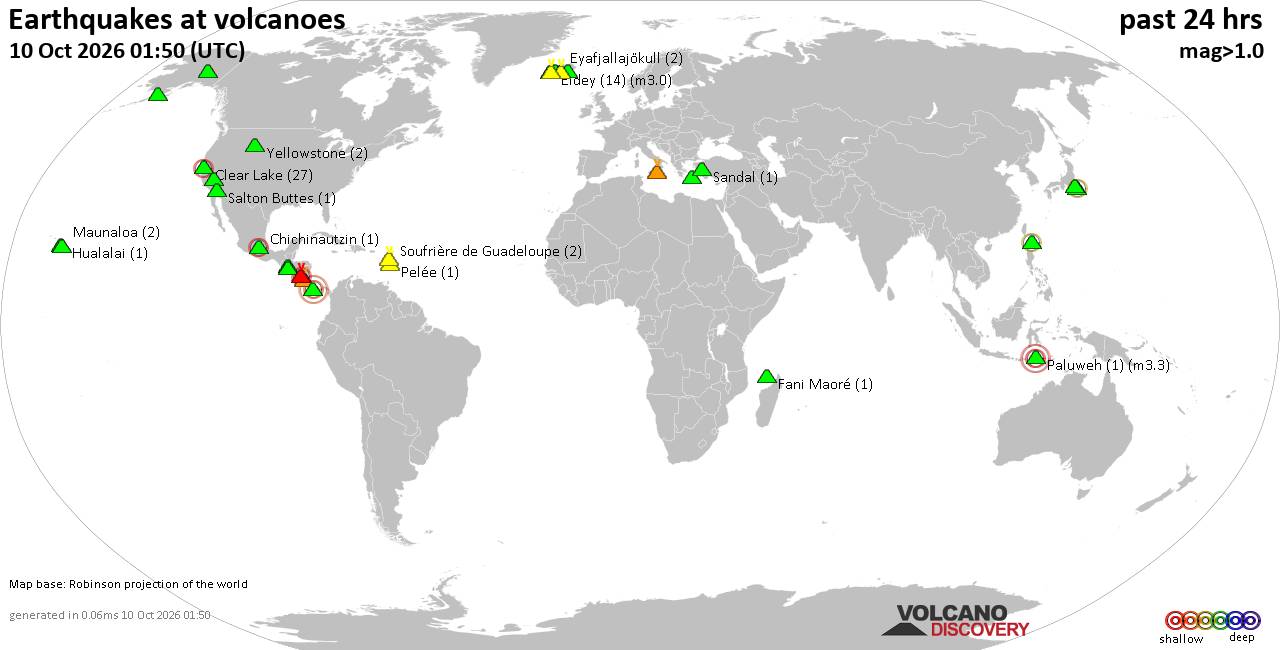
Volcano earthquake report for Saturday, 10 October 2026
• M 1.1 - 8 km WNW of Cobb, CA
• M 1.1 - 8 km WNW of Cobb, CA
• M 5.3 - 41 km NNE of Yigo Village, Guam
• M 5.3 - 41 km NNE of Yigo Village, Guam
• M 4.9 - 26 km SSE of Pedasí, Panama
|
 Monday: Light Rain, Minimum Temperature: 16°C (60°F) Maximum Temperature: 19°C (66°F)
Webmaster
7 minutes ago
Monday: Light Rain, Minimum Temperature: 16°C (60°F) Maximum Temperature: 19°C (66°F)
Webmaster
7 minutes ago
Maximum Temperature: 19°C (66°F), Minimum Temperature: 16°C (60°F), Wind Direction: south-easterly, Wind Speed: 6mph, Visibility: Moderate, Pressure: 1010mb, Humidity: 90%, UV Risk: 1, Pollution: Low, Sunrise: 07:30 BST, Sunset: 18:20 BST Source: Monday: Light Rain, Minimum Temperature: 16°C (60°F) Maximum Temperature: 19°C (66°F)
0
Read More
|
Sunday: Light Cloud, Minimum Temperature: 10°C (50°F) Maximum Temperature: 15°C (58°F)
Webmaster
7 minutes ago
Maximum Temperature: 15°C (58°F), Minimum Temperature: 10°C (50°F), Wind Direction: south-westerly, Wind Speed: 3mph, Visibility: Good, Pressure: 1013mb, Humidity: 73%, UV Risk: 2, Pollution: Low, Sunrise: 07:28 BST, Sunset: 18:23 BST Source: Sunday: Light Cloud, Minimum Temperature: 10°C (50°F) Maximum Temperature: 15°C (58°F)
0
Read More
|
Today: Light Rain Showers, Minimum Temperature: 7°C (45°F) Maximum Temperature: 13°C (55°F)
Webmaster
7 minutes ago
Maximum Temperature: 13°C (55°F), Minimum Temperature: 7°C (45°F), Wind Direction: westerly, Wind Speed: 14mph, Visibility: Good, Pressure: 1011mb, Humidity: 72%, UV Risk: 2, Pollution: Low, Sunrise: 07:26 BST, Sunset: 18:25 BST Source: Today: Light Rain Showers, Minimum Temperature: 7°C (45°F) Maximum Temperature: 13°C (55°F)
0
Read More
|
Hurricane Simon Forecast Discussion Number 12
Webmaster
11 minutes ago
Issued at 300 AM CST Sat Oct 10 2026 000
WTPZ45 KNHC 100857
TCDEP5
Hurricane Simon Discussion Number 12
NWS National Hurricane Center Miami FL EP202026
300 AM CST Sat Oct 10 2026
The very small inner-core of Simon remains very impressive as the
cyclone has continued to strengthen. The proxy-visible imagery has
started to show that the tiny eye of the hurricane is clearing
out. The most recent TAFB Dvorak fix was a T6.0/115 kt,
while the objective raw T-number intensity estimates from
UW-CIMSS have ranged from 120 to 132 kt. Based on a blend of the
objective and subjective intensity estimates, the initial intensity
has been increased to 125 kt for this advisory. The wind radii has
been adjusted based on a recent ASCAT pass.
The hurricane is expected to continue to rapidly strengthen over
the next day or so, with a peak intensity of 135 kt forecast. Given
the small size of the inner core, there is a higher than normal
degree of uncertainty with the peak intensity. Therefore, it is
possible that Simon could become stronger than what is forecast.
Only a few changes were made for the current NHC forecast compared
to the previous forecast.
Simon's initial motion is estimated at 360/4 kt, northward.
The hurricane is being steered by the southerly mid-level flow
produced by high pressure over southern Mexico and a longwave
mid-tropospheric trough to the west stretching south-southwestward
from the southwest United States. There is still some uncertainty
about the track for Simon, as most of the skilled model guidance
including HCCA and GDMI forecast aids have been experiencing to the
left of the track bias. The current NHC track forecast has the
hurricane move inland over the Mexican states of Colima and
Jalisco; however, it is possible that the cyclone could remain just
offshore as it moves generally northward. Should Simon move inland,
then it should dissipate quickly due to the mountainous terrain.
However, if Simon were to stay offshore, then it would maintain
hurricane intensity for a longer period of time. The current track
forecast is similar to the previous one, with only a few small
adjustments being made.
Key Messages:
1. Catastrophic wind and life-threatening storm surge impacts are
likely along a portion of the west-central coast of Mexico, and a
Hurricane warning is in effect from Punta San Telmo to Punta Mita.
Preparations to protect life and property should be completed
today.
2. Heavy rainfall associated with Simon will impact portions of
southwestern Mexico through this weekend. This rainfall will produce
life-threatening flooding and mudslides, especially in areas of
steep terrain.
3. Swells will affect portions of the southwestern and west-central
coast of Mexico through the weekend. These swells are likely to
cause life-threatening surf and rip current conditions. Please
consult products from your local weather office.
FORECAST POSITIONS AND MAX WINDS
INIT 10/0900Z 17.2N 104.6W 125 KT 145 MPH
12H 10/1800Z 17.8N 104.7W 135 KT 155 MPH
24H 11/0600Z 18.8N 104.9W 135 KT 155 MPH
36H 11/1800Z 20.0N 105.1W 120 KT 140 MPH...INLAND
48H 12/0600Z 21.7N 105.3W 70 KT 80 MPH...INLAND
60H 12/1800Z 23.1N 105.6W 30 KT 35 MPH...POST-TROP/INLAND
72H 13/0600Z...DISSIPATED
$$
Forecaster Katz/Roberts Source: Hurricane Simon Forecast Discussion Number 12
0
Read More
|
Tropical Storm Rachel Forecast Discussion Number 53
Webmaster
15 minutes ago
Issued at 200 AM PDT Sat Oct 10 2026 000
WTPZ43 KNHC 100853
TCDEP3
Tropical Storm Rachel Discussion Number 53
NWS National Hurricane Center Miami FL EP182026
200 AM PDT Sat Oct 10 2026
Satellite imagery indicates that Rachel's convective organization
has changed little over the past several hours, with the deepest
convection remaining confined to the northern and northeastern
portions of the circulation due to increasing southwesterly vertical
wind shear. A 0505 UTC ASCAT-B scatterometer pass revealed peak
winds of around 46 kt and an expanding wind field, which helped
refine the initial wind radii. Based on these data, the initial
intensity is set at 50 kt.
The initial motion is northeastward, or 050/19 kt. A turn toward the
north-northeast, accompanied by additional acceleration to around 25
kt, is expected during the next 24 h as Rachel interacts with a
deepening mid- to upper-level trough over the western United States.
This motion should bring Rachel ashore just south of the
U.S./Mexico border tonight, followed by a rapid north-northeastward
motion into the southwestern United States. Track guidance has
shifted slightly to the right compared to 24 hours ago, but has
changed little since the previous cycle. The latest NHC track
forecast is essentially unchanged from the previous prediction and
lies close to the HCCA and GDMI aids.
Some additional strengthening is possible during the next 12 to 24 h
as Rachel accelerates northeastward and interacts with the deepening
upper-level trough. The NHC intensity forecast shows Rachel
strengthening to 55 kt before moving inland tonight. Rachel's wind
field has also begun to expand, and additional expansion is
possible as the cyclone accelerates northeastward and
interacts with the upper-level trough. This could result in
tropical-storm-force winds extending farther from the center as
Rachel begins to lose its tropical characteristics. Rachel is
expected to weaken rapidly after landfall as it encounters the
mountainous terrain of northern Baja California and the southwestern
United States. The cyclone is forecast to become post-tropical by 36
h and dissipate by 48 h. The latest NHC intensity forecast is
similar to the previous prediction and lies near the middle to upper
end of the guidance envelope.
Key Messages:
1. Rachel is expected to approach and move ashore along the coast of
northern Baja California or extreme Southern California at tropical
storm strength tonight. Tropical storm conditions are expected in
portions of northern Baja California, Mexico, where Tropical Storm
Warnings are in effect. Tropical storm conditions are also possible
in extreme Southern California, eastern Baja California, and
portions of northwestern Mexico where Tropical Storm Watches are in
effect.
2. Damaging wind gusts associated with Rachel and its remnants are
expected to spread over portions of northwestern Mexico and interior
portions of the Southwest United States, especially in areas of
higher terrain, tonight and Sunday.
3. Rachel and its moisture will spread over portions of the
Southwest United States and northern Baja California peninsula
through this weekend. This will lead to increasing coverage of
rainfall and for the potential for significant flash and urban
flooding.
4. Waves generated by Rachel, combined with an incoming long-period
southerly swell, will produce life-threatening surf and rip current
conditions along the coasts of Southern California and northern Baja
California. Major coastal flooding has already been occurring in
some areas, with observed water levels running as much as 1.5 feet
above predictions. Coastal flooding and erosion are expected to
worsen tonight into Sunday morning as the highest waves associated
with Rachel coincide with high tides and already elevated water
levels. Hazardous coastal conditions are expected to continue into
early next week. Please consult products from your local weather
office.
FORECAST POSITIONS AND MAX WINDS
INIT 10/0900Z 24.2N 121.4W 50 KT 60 MPH
12H 10/1800Z 26.6N 119.0W 55 KT 65 MPH
24H 11/0600Z 31.0N 116.6W 55 KT 65 MPH
36H 11/1800Z 36.0N 114.1W 40 KT 45 MPH...POST-TROP/INLAND
48H 12/0600Z...DISSIPATED
$$
Forecaster Gibbs Source: Tropical Storm Rachel Forecast Discussion Number 53
0
Read More
|
Tropical Storm Rachel Wind Speed Probabilities Number 53
Webmaster
15 minutes ago
Issued at 0900 UTC SAT OCT 10 2026 000
FOPZ13 KNHC 100852
PWSEP3
TROPICAL STORM RACHEL WIND SPEED PROBABILITIES NUMBER 53
NWS NATIONAL HURRICANE CENTER MIAMI FL EP182026
0900 UTC SAT OCT 10 2026
AT 0900Z THE CENTER OF TROPICAL STORM RACHEL WAS LOCATED NEAR
LATITUDE 24.2 NORTH...LONGITUDE 121.4 WEST WITH MAXIMUM SUSTAINED
WINDS NEAR 50 KTS...60 MPH...95 KM/H.
Z INDICATES COORDINATED UNIVERSAL TIME (GREENWICH)
PACIFIC DAYLIGHT TIME (PDT)...SUBTRACT 7 HOURS FROM Z TIME
HAWAIIAN STANDARD TIME (HST)...SUBTRACT 10 HOURS FROM Z TIME
WIND SPEED PROBABILITY TABLE FOR SPECIFIC LOCATIONS
CHANCES OF SUSTAINED (1-MINUTE AVERAGE) WIND SPEEDS OF AT LEAST
...34 KT (39 MPH... 63 KM/H)...
...50 KT (58 MPH... 93 KM/H)...
...64 KT (74 MPH...119 KM/H)...
FOR LOCATIONS AND TIME PERIODS DURING THE NEXT 5 DAYS
PROBABILITIES FOR LOCATIONS ARE GIVEN AS OP(CP) WHERE
OP IS THE PROBABILITY OF THE EVENT BEGINNING DURING
AN INDIVIDUAL TIME PERIOD (ONSET PROBABILITY)
(CP) IS THE PROBABILITY OF THE EVENT OCCURRING BETWEEN
06Z SAT AND THE FORECAST HOUR (CUMULATIVE PROBABILITY)
PROBABILITIES ARE GIVEN IN PERCENT
X INDICATES PROBABILITIES LESS THAN 1 PERCENT
PROBABILITIES FOR 34 KT AND 50 KT ARE SHOWN AT A GIVEN LOCATION WHEN
THE 5-DAY CUMULATIVE PROBABILITY IS AT LEAST 3 PERCENT.
PROBABILITIES FOR 34...50...64 KT SHOWN WHEN THE 5-DAY
64-KT CUMULATIVE PROBABILITY IS AT LEAST 1 PERCENT.
- - - - WIND SPEED PROBABILITIES FOR SELECTED LOCATIONS - - - -
FROM FROM FROM FROM FROM FROM FROM
TIME 06Z SAT 18Z SAT 06Z SUN 18Z SUN 06Z MON 06Z TUE 06Z WED
PERIODS TO TO TO TO TO TO TO
18Z SAT 06Z SUN 18Z SUN 06Z MON 06Z TUE 06Z WED 06Z THU
FORECAST HOUR (12) (24) (36) (48) (72) (96) (120)
- - - - - - - - - - - - - - - - - - - - - - - - - - - - - - - - - -
LOCATION KT
SAN DIEGO CA 34 X 7( 7) 11(18) X(18) X(18) X(18) X(18)
YUMA AZ 34 X X( X) 22(22) X(22) X(22) X(22) X(22)
TIJUANA 34 X 2( 2) 12(14) X(14) X(14) X(14) X(14)
ENSENADA 34 X 35(35) 16(51) X(51) X(51) X(51) X(51)
ENSENADA 50 X 9( 9) 11(20) X(20) X(20) X(20) X(20)
ENSENADA 64 X 1( 1) 2( 3) X( 3) X( 3) X( 3) X( 3)
IS GUADALUPE 34 2 68(70) X(70) X(70) X(70) X(70) X(70)
IS GUADALUPE 50 X 24(24) X(24) X(24) X(24) X(24) X(24)
IS GUADALUPE 64 X 2( 2) X( 2) X( 2) X( 2) X( 2) X( 2)
PUNTA EUGENIA 34 X 10(10) X(10) X(10) X(10) X(10) X(10)
P PENASCO 34 X 4( 4) 4( 8) X( 8) X( 8) X( 8) X( 8)
25N 120W 34 99 X(99) X(99) X(99) X(99) X(99) X(99)
25N 120W 50 8 X( 8) X( 8) X( 8) X( 8) X( 8) X( 8)
30N 120W 34 X 3( 3) X( 3) X( 3) X( 3) X( 3) X( 3)
$$
FORECASTER GIBBS Source: Tropical Storm Rachel Wind Speed Probabilities Number 53
0
Read More
|
Tropical Storm Rachel Public Advisory Number 53
Webmaster
16 minutes ago
Issued at 200 AM PDT Sat Oct 10 2026 000
WTPZ33 KNHC 100852
TCPEP3
BULLETIN
Tropical Storm Rachel Advisory Number 53
NWS National Hurricane Center Miami FL EP182026
200 AM PDT Sat Oct 10 2026
...RACHEL HOLDING STEADY WHILE ACCELERATING NORTHEASTWARD...
SUMMARY OF 200 AM PDT...0900 UTC...INFORMATION
----------------------------------------------
LOCATION...24.2N 121.4W
ABOUT 640 MI...1035 KM SSW OF SAN DIEGO CALIFORNIA
MAXIMUM SUSTAINED WINDS...60 MPH...95 KM/H
PRESENT MOVEMENT...NE OR 50 DEGREES AT 22 MPH...35 KM/H
MINIMUM CENTRAL PRESSURE...992 MB...29.30 INCHES
WATCHES AND WARNINGS
--------------------
CHANGES WITH THIS ADVISORY:
None.
SUMMARY OF WATCHES AND WARNINGS IN EFFECT:
A Tropical Storm Warning is in effect for...
* West coast of Baja California, from San Jose de Las Palomas
northward to the U.S./Mexico Border
* East coast of Baja California, from Isla San Luis northward to
Puerto Penasco
A Tropical Storm Watch is in effect for...
* Southern California coast from the U.S/Mexico Border northward to
the San Diego/Orange County Line
* East coast of Baja California, from Bahia De Los Angeles
northward to Isla San Luis
* Northwest Mexico from Puerto Libertad to Puerto Penasco
A Tropical Storm Warning means that tropical storm conditions are
expected somewhere within the warning area within 36 hours.
A Tropical Storm Watch means that tropical storm conditions are
possible within the watch area, generally within 48 hours.
Interests in northern Baja California, northern Gulf of California,
and Southern California should continue to monitor the progress of
Rachel.
For storm information specific to your area in the United
States, including possible inland watches and warnings, please
monitor products issued by your local National Weather Service
forecast office. For storm information specific to your area
outside of the United States, please monitor products issued by
your national meteorological service.
DISCUSSION AND OUTLOOK
----------------------
At 200 AM PDT (0900 UTC), the center of Tropical Storm Rachel was
located near latitude 24.2 North, longitude 121.4 West. Rachel is
moving toward the northeast near 22 mph (35 km/h). A turn toward
the north-northeast, accompanied by an additional increase in
forward speed, is expected through Sunday. On the forecast track,
the center of Rachel is expected to approach and move ashore near
the U.S./Mexico border tonight.
Maximum sustained winds are near 60 mph (95 km/h) with higher gusts.
Some additional strengthening is possible through tonight, but
rapid weakening is expected after Rachel moves inland over Baja
California and the southwestern United States on Sunday.
Tropical-storm-force winds extend outward up to 125 miles (205 km)
from the center.
The estimated minimum central pressure is 992 mb (29.30 inches).
HAZARDS AFFECTING LAND
----------------------
Key messages for Rachel can be found in the Tropical Cyclone
Discussion under AWIPS header MIATCDEP3 and WMO header WTPZ43 KNHC.
WIND: Tropical storm conditions are expected to reach portions of
northern Baja California within the Tropical Storm Warning area
beginning later today and continuing into Sunday morning. Tropical
storm conditions are also possible within the Tropical Storm Watch
area in extreme Southern California, eastern Baja California, and
portions of northwest Mexico beginning tonight or early Sunday.
Strong gusty winds associated with the system are expected to spread
over interior portions of the Southwest United States, especially in
areas of higher terrain, later today through early next week.
RAINFALL: Rachel will bring 1 to 3 inches of rain to portions of
Baja California this weekend.
Rachel and its associated moisture will also bring rainfall of 1 to
3 inches, with maximum amounts locally up to 5 inches in portions of
the Southwest United States this weekend. This will lead to
increasing coverage of rainfall and potential for significant flash
and urban flooding.
For a complete depiction of forecast rainfall associated with
Rachel, please see the National Weather Service Storm Total Rainfall
Graphic available at hurricanes.gov/graphics_ep3.shtml?rainqpf and
the Flash Flood Risk graphic at
hurricanes.gov/graphics_ep3.shtml?ero.
SURF: Waves generated by Rachel will continue to build along the
coasts of Southern California and northern Baja California today.
These waves, combined with an incoming long-period southerly swell,
will cause life-threatening surf and rip current conditions. Coastal
flooding and erosion are expected to worsen tonight into Sunday
morning as the highest waves coincide with the high tides and water
levels that are already running well above predicted levels.
Moderate to major coastal flooding is expected, with hazardous
coastal conditions continuing into early next week. Please consult
products from your local weather office.
NEXT ADVISORY
-------------
Next intermediate advisory at 500 AM PDT.
Next complete advisory at 800 AM PDT.
$$
Forecaster Gibbs Source: Tropical Storm Rachel Public Advisory Number 53
0
Read More
|
Tropical Storm Rachel Forecast Advisory Number 53
Webmaster
16 minutes ago
Issued at 0900 UTC SAT OCT 10 2026 652
WTPZ23 KNHC 100851
TCMEP3
TROPICAL STORM RACHEL FORECAST/ADVISORY NUMBER 53
NWS NATIONAL HURRICANE CENTER MIAMI FL EP182026
0900 UTC SAT OCT 10 2026
TROPICAL STORM CENTER LOCATED NEAR 24.2N 121.4W AT 10/0900Z
POSITION ACCURATE WITHIN 20 NM
PRESENT MOVEMENT TOWARD THE NORTHEAST OR 50 DEGREES AT 19 KT
ESTIMATED MINIMUM CENTRAL PRESSURE 992 MB
MAX SUSTAINED WINDS 50 KT WITH GUSTS TO 60 KT.
50 KT....... 30NE 0SE 0SW 40NW.
34 KT....... 60NE 110SE 110SW 70NW.
4 M SEAS.... 60NE 180SE 180SW 90NW.
WINDS AND SEAS VARY GREATLY IN EACH QUADRANT. RADII IN NAUTICAL
MILES ARE THE LARGEST RADII EXPECTED ANYWHERE IN THAT QUADRANT.
REPEAT...CENTER LOCATED NEAR 24.2N 121.4W AT 10/0900Z
AT 10/0600Z CENTER WAS LOCATED NEAR 24.1N 122.2W
FORECAST VALID 10/1800Z 26.6N 119.0W
MAX WIND 55 KT...GUSTS 65 KT.
50 KT... 30NE 20SE 0SW 40NW.
34 KT... 70NE 130SE 100SW 70NW.
FORECAST VALID 11/0600Z 31.0N 116.6W
MAX WIND 55 KT...GUSTS 65 KT.
50 KT... 30NE 30SE 20SW 30NW.
34 KT... 80NE 130SE 70SW 60NW.
FORECAST VALID 11/1800Z 36.0N 114.1W...POST-TROP/INLAND
MAX WIND 40 KT...GUSTS 50 KT.
34 KT... 70NE 120SE 40SW 20NW.
FORECAST VALID 12/0600Z...DISSIPATED
REQUEST FOR 3 HOURLY SHIP REPORTS WITHIN 300 MILES OF 24.2N 121.4W
INTERMEDIATE PUBLIC ADVISORY...WTNT33 KNHC/MIATCPEP3...AT 10/1200Z
NEXT ADVISORY AT 10/1500Z
$$
FORECASTER GIBBS Source: Tropical Storm Rachel Forecast Advisory Number 53
0
Read More
|
Post-Tropical Cyclone Isaias Forecast Discussion Number 15
Webmaster
22 minutes ago
Issued at 400 AM CDT Sat Oct 10 2026 000
WTNT44 KNHC 100845
TCDAT4
Post-Tropical Cyclone Isaias Discussion Number 15
NWS National Hurricane Center Miami FL AL092026
400 AM CDT Sat Oct 10 2026
Isaias has very rapidly weakened over Alabama and has transitioned
into a post-tropical cyclone. Satellite images show that all deep
convection has been scoured well northward away from the low-level
center, with a warm front extending eastward from the former
tropical cyclone. Thus this is the last advisory on Isaias, with
an initial intensity of 30 kt set from surface observations.
The cyclone should move northward and north-northeastward this
weekend and gradually weaken as it moves across the Tennessee and
Ohio Valleys. No significant changes were made to the track or
intensity forecasts, except lower wind speed on day 1. Note there
is still a risk of some high wind gusts over the southern
Appalachians as the cyclone moves just to the west of those
mountains, along with the potential for heavy rain causing flash
floods.
This is the last tropical cyclone discussion issued by the National
Hurricane Center on this system. Future information on this system
can be found in discussions issued by the Weather Prediction Center
beginning at 1000 AM CDT, under AWIPS header TCDAT4, WMO header
WTNT44 KWNH, and on the web at www.hurricanes.gov.
Rainfall forecasts for the United States are at:
https://www.wpc.ncep.noaa.gov/qpf/qpf2.shtml
and outlooks of flash flood risks can be found at
https://www.wpc.ncep.noaa.gov/qpf/excessive_rainfall_outlook_ero.php
Key Messages:
1. Heavy rainfall associated with the post-tropical remnants of
Isaias will be spreading quickly northward into the Tennessee
Valley, Southern Appalachians and Southeast today. Considerable
flash and urban flooding will be possible. Landslides are also
possible across the Southern Appalachians. Additional heavy rains
are possible across portions of Northwest Florida and heavy rains
are also possible across coastal Southwest Florida, resulting in
flash and urban flooding.
2. Post-storm safety: Follow advice of local officials and avoid
areas of downed power lines and flooding. Ensure generators are
properly ventilated and placed outside at least 20 feet away from
dwellings and garages to avoid carbon monoxide poisoning. During
clean up, be careful when using chainsaws and power tools. Drink
plenty of water to avoid heat exhaustion.
FORECAST POSITIONS AND MAX WINDS
INIT 10/0900Z 32.0N 86.5W 30 KT 35 MPH...POST-TROPICAL
12H 10/1800Z 33.7N 86.7W 25 KT 30 MPH...POST-TROP/INLAND
24H 11/0600Z 35.2N 86.0W 25 KT 30 MPH...POST-TROP/INLAND
36H 11/1800Z 37.6N 82.7W 20 KT 25 MPH...POST-TROP/INLAND
48H 12/0600Z...DISSIPATED
$$
Forecaster Blake Source: Post-Tropical Cyclone Isaias Forecast Discussion Number 15
0
Read More
|
Post-Tropical Cyclone Isaias Wind Speed Probabilities Number 15
Webmaster
24 minutes ago
Issued at 0900 UTC SAT OCT 10 2026 000
FONT14 KNHC 100844
PWSAT4
POST-TROPICAL CYCLONE ISAIAS WIND SPEED PROBABILITIES NUMBER 15
NWS NATIONAL HURRICANE CENTER MIAMI FL AL092026
0900 UTC SAT OCT 10 2026
AT 0900Z THE CENTER OF POST-TROPICAL CYCLONE ISAIAS WAS LOCATED NEAR
LATITUDE 32.0 NORTH...LONGITUDE 86.5 WEST WITH MAXIMUM SUSTAINED
WINDS NEAR 30 KTS...35 MPH...55 KM/H.
Z INDICATES COORDINATED UNIVERSAL TIME (GREENWICH)
ATLANTIC STANDARD TIME (AST)...SUBTRACT 4 HOURS FROM Z TIME
EASTERN DAYLIGHT TIME (EDT)...SUBTRACT 4 HOURS FROM Z TIME
CENTRAL DAYLIGHT TIME (CDT)...SUBTRACT 5 HOURS FROM Z TIME
WIND SPEED PROBABILITY TABLE FOR SPECIFIC LOCATIONS
CHANCES OF SUSTAINED (1-MINUTE AVERAGE) WIND SPEEDS OF AT LEAST
...34 KT (39 MPH... 63 KM/H)...
...50 KT (58 MPH... 93 KM/H)...
...64 KT (74 MPH...119 KM/H)...
FOR LOCATIONS AND TIME PERIODS DURING THE NEXT 5 DAYS
PROBABILITIES FOR LOCATIONS ARE GIVEN AS OP(CP) WHERE
OP IS THE PROBABILITY OF THE EVENT BEGINNING DURING
AN INDIVIDUAL TIME PERIOD (ONSET PROBABILITY)
(CP) IS THE PROBABILITY OF THE EVENT OCCURRING BETWEEN
06Z SAT AND THE FORECAST HOUR (CUMULATIVE PROBABILITY)
PROBABILITIES ARE GIVEN IN PERCENT
X INDICATES PROBABILITIES LESS THAN 1 PERCENT
PROBABILITIES FOR 34 KT AND 50 KT ARE SHOWN AT A GIVEN LOCATION WHEN
THE 5-DAY CUMULATIVE PROBABILITY IS AT LEAST 3 PERCENT.
PROBABILITIES FOR 34...50...64 KT SHOWN WHEN THE 5-DAY
64-KT CUMULATIVE PROBABILITY IS AT LEAST 1 PERCENT.
- - - - WIND SPEED PROBABILITIES FOR SELECTED LOCATIONS - - - -
FROM FROM FROM FROM FROM FROM FROM
TIME 06Z SAT 18Z SAT 06Z SUN 18Z SUN 06Z MON 06Z TUE 06Z WED
PERIODS TO TO TO TO TO TO TO
18Z SAT 06Z SUN 18Z SUN 06Z MON 06Z TUE 06Z WED 06Z THU
FORECAST HOUR (12) (24) (36) (48) (72) (96) (120)
- - - - - - - - - - - - - - - - - - - - - - - - - - - - - - - - - -
LOCATION KT
TALLAHASSEE FL 34 24 X(24) X(24) X(24) X(24) X(24) X(24)
APALACHICOLA 34 4 X( 4) X( 4) X( 4) X( 4) X( 4) X( 4)
PANAMA CITY FL 34 96 X(96) X(96) X(96) X(96) X(96) X(96)
DESTIN EXEC AP 34 99 X(99) X(99) X(99) X(99) X(99) X(99)
ALBANY GA 34 94 X(94) X(94) X(94) X(94) X(94) X(94)
COLUMBUS GA 34 99 X(99) X(99) X(99) X(99) X(99) X(99)
DOTHAN AL 34 99 X(99) X(99) X(99) X(99) X(99) X(99)
BIRMINGHAM AL 34 77 X(77) X(77) X(77) X(77) X(77) X(77)
MONTGOMERY AL 34 99 X(99) X(99) X(99) X(99) X(99) X(99)
WHITING FLD FL 34 99 X(99) X(99) X(99) X(99) X(99) X(99)
PENSACOLA FL 34 98 X(98) X(98) X(98) X(98) X(98) X(98)
$$
FORECASTER BLAKE Source: Post-Tropical Cyclone Isaias Wind Speed Probabilities Number 15
0
Read More
|
|
Forums60
Topics867,276
Posts902,072
Members2,960
| |
Most Online102,106
Jul 10th, 2026
|
|
|











































