|
|
|
0 members (),
1,873
guests, and
28
robots. |
|
Key:
Admin,
Global Mod,
Mod
|
|
S |
M |
T |
W |
T |
F |
S |
|
1
|
2
|
3
|
4
|
5
|
6
|
7
|
|
8
|
9
|
10
|
11
|
12
|
13
|
14
|
|
15
|
16
|
17
|
18
|
19
|
20
|
21
|
|
22
|
23
|
24
|
25
|
26
|
27
|
28
|
|
29
|
30
|
31
|
|
|
|
|
|
There are no members with birthdays on this day. |
 SPC Mar 3, 2026 2000 UTC Day 1 Convective Outlook
Webmaster
3 hours ago
SPC Mar 3, 2026 2000 UTC Day 1 Convective Outlook
Webmaster
3 hours ago
SPC Mar 3, 2026 2000 UTC Day 1 Convective OutlookSPC 2000Z Day 1 Outlook 
Day 1 Convective Outlook CORR 1
NWS Storm Prediction Center Norman OK
0232 PM CST Tue Mar 03 2026

Valid 032000Z - 041200Z

...THERE IS A MARGINAL RISK OF SEVERE THUNDERSTORMS THE
SOUTHERN/CENTRAL PLAINS INTO MISSOURI AND WESTERN ILLINOIS...

CORRECTED FOR TESTING THE CORRECTION PROCESS

...SUMMARY...
Isolated severe hail may occur this evening into the overnight hours
across parts of the southern/central Plains into Missouri and
western Illinois.

...20z Update...
The Marginal Risk continues across parts of the southern/central
Plains into Missouri and western Illinois. Moisture continues
northward, observed in visible satellite and 60 F dew points
increasing from the south into southern Kansas. Thunderstorm
development is still expected to be delayed into the evening as
modest capping remains in place. Some conditional risk for large
hail (some up to 1.5-2" in diameter) will be possible, mainly across
northwest Oklahoma into southern Kansas. In this region, a favorable
overlap of MLCAPE around 1000-1500 J/kg will overlap with steep
mid-level lapse rates and deep layer shear near the frontal
boundary.

..Thornton.. 03/03/2026

.PREV DISCUSSION... /ISSUED 1030 AM CST Tue Mar 03 2026/

...Southern/Central Plains into Missouri and Western Illinois...
Water-vapor imagery this morning shows a mid-level shortwave trough
over the central Rockies and this feature will move into the central
High Plains late tonight.  A frontal zone this morning is draped
from near the Raton Mesa into the TX Panhandle extends
east-northeastward across northern OK into the Ozarks.  A weak
surface low over northeast NM and the OK/TX Panhandles this morning
will gradually develop towards northwest TX by this evening.
Southerly low-level flow will maintain a moist fetch into OK today
and into the Ozarks and parts of the mid MS Valley.  A dryline is
forecast to mix eastward across the southern High Plains by late
this afternoon, intersecting the surface front in the northwest
TX/southwest OK vicinity.

Convection will likely be inhibited during the day across much of
the MRGL Risk owing to both capping and weak mid-level shortwave
ridging.  The strongest heating and low-level convergence is
forecast across parts of northwest TX/southwest OK where convective
inhibition will become weakened by late afternoon.  Have adjusted
severe hail probabilities farther south into parts of northwest TX
to account for the potential for a supercell or two this evening
into the overnight hours.  As large-scale forcing for ascent
continues to strengthen through the evening into the overnight,
expected widely scattered thunderstorms to eventually develop near
the frontal zone (perhaps favoring a northwest OK/southern KS
corridor).  Large hail will be the hazard with the stronger storms.
Around 1000-1500 J/kg of MUCAPE, steepened mid-level lapse rates,
and strong effective bulk shear suggest that some of these cells may
pose a threat for isolated severe hail as they spread from OK/KS
into MO and western IL through early Wednesday morning.
Read morehttps://www.spc.noaa.gov/products/outlook/day1otlk_2000.html
0
4
Read More
|
SPC Mar 3, 2026 1930 UTC Day 3 Severe Thunderstorm Outlook
Webmaster
3 hours ago
SPC Mar 3, 2026 1930 UTC Day 3 Severe Thunderstorm OutlookSPC 1930Z Day 3 Outlook 
Day 3 Convective Outlook
NWS Storm Prediction Center Norman OK
0127 PM CST Tue Mar 03 2026

Valid 051200Z - 061200Z

...THERE IS A SLIGHT RISK OF SEVERE THUNDERSTORMS THURSDAY AFTERNOON
INTO THURSDAY NIGHT FROM WEST TEXAS INTO SOUTHWEST/CENTRAL KANSAS...

...SUMMARY...
Scattered severe thunderstorms are expected Thursday afternoon and
into Thursday night from west Texas into Kansas.  Large hail appears
to be the main threat, though a couple of tornadoes and isolated
severe gusts will also be possible.

...Southern/central Plains Thursday afternoon/night...
Amplification of a midlevel trough is expected near the Four Corners
Thursday into Thursday night, as a downstream lee cyclone deepens
across eastern CO.  The deepening cyclone will draw moisture
northward from TX across the southern/central Plains through early
Friday in the developing warm sector.  The lee trough/dryline will
be located near or just west of the KS/CO and TX/NM borders by late
afternoon as the cyclone deepens in place.  Surface heating in cloud
breaks could allow sufficient vertical mixing to weaken convective
inhibition and allow isolated thunderstorm development along and
just east of the dryline by late afternoon across the TX
Panhandle/South Plains into southwest KS.  The storm environment
will conditionally favor supercells capable of producing large hail
near or just in excess of 2 inches in diameter.  The tornado threat
will be a little greater by early evening as low-level shear
increases and near 60 F dewpoints surge northward from OK into KS,
though the tornado threat will depend on a supercell or two
persisting into late evening.

Otherwise, elevated convection will spread northeastward Thursday
night as the low-level jet and associated warm/moist advection
increase.  Steep midlevel lapse rates will support the potential for
large hail with the overnight convection as far north as NE/IA.

..Thompson.. 03/03/2026
Read morehttps://www.spc.noaa.gov/products/outlook/day3otlk_1930.html
0
5
Read More
|
World Earthquake Report for March 2026
Webmaster
4 hours ago
World Earthquake Report for March 2026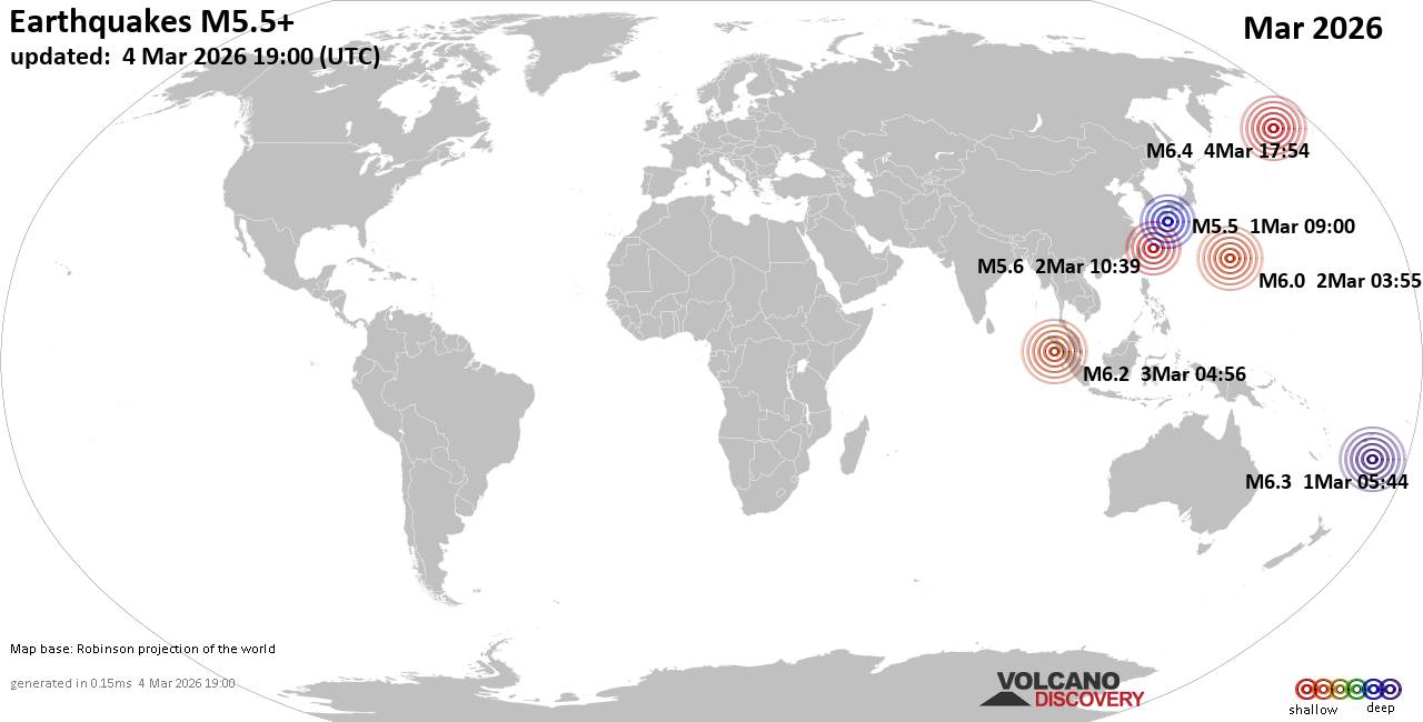 Worldwide earthquakes above magnitude 5.5 during March 2026 Magnitude 9+: none Magnitude 8+: none Magnitude 7+: none Magnitude 6+: 3 earthquakes Magnitude 5+: 14 earthquakes Magnitude 4+: 111 earthquakes Magnitude 3+: 412 earthquakes Magnitude 2+: 963 earthquakes No quakes of magnitude 7 or higher List of 10 largest earthquakes in the world during March 2026:Sunday, Mar 1, 2026, at 06:44 pm (GMT +13) - Tuesday, Mar 3, 2026, at 11:56 am (Pontianak time) - Monday, Mar 2, 2026, at 01:55 pm (GMT +10) - Monday, Mar 2, 2026, at 07:39 pm (GMT +9) - Sunday, Mar 1, 2026, at 06:00 pm (GMT +9) - Earthquake stats:   https://www.volcanodiscovery.com/view_news/296458/World-Earthquake-Report-for-March-2026.html https://www.volcanodiscovery.com/view_news/296458/World-Earthquake-Report-for-March-2026.html
0
7
Read More
|
Volcano earthquake report for Tuesday, 3 Mar 2026
Webmaster
4 hours ago
Volcano earthquake report for Tuesday, 3 Mar 2026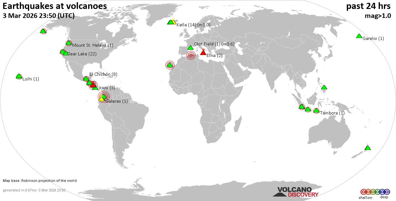 World map showing volcanoes with shallow (less than 50 km) earthquakes within 20 km radius during the past 24 hours on 3 Mar 2026 Number in brackets indicate nr of quakes. Quakes detected near: Apaneca Range (3 quakes between mag 1.4-2.1), Cabalian (2 quakes between mag 1.9-3.1), Cerro Singüil (1 quake mag 2.6), Clear Lake (25 quakes between mag 0.2-2.0), El Chichón (9 quakes between mag 1.8-2.6), Etna (3 quakes between mag 1.0-1.6)
Granada (1 quake mag 3.0), Hulubelu (4 quakes between mag 2.1-2.3), Jailolo (1 quake mag 2.4), Katla (21 quakes between mag 0.0-3.0), Krísuvík (8 quakes between mag 0.0-1.5), Kupreanof (1 quake mag 2.5), Mammoth Mountain (6 quakes between mag 0.3-1.3), Maroa (4 quakes between mag 1.0-1.4), Masaya (1 quake mag 1.8), Maunaloa (2 quakes between mag 1.7-1.8), Mount St. Helens (1 quake mag 2.0), Nevado del Huila (2 quakes between mag 4.0-4.0), Olot Field (1 quake mag 3.6), Reporoa (2 quakes between mag 1.7-2.4), Sekincau Belirang (1 quake mag 2.2), Stepovak Bay 2 (1 quake mag 1.8), Sumbing (1 quake mag 2.1), Tecapa (1 quake mag 3.0), Tenerife (2 quakes between mag 1.5-3.0), Ugashik-Peulik (1 quake mag 1.7), Vesuvius (4 quakes between mag 0.1-1.0) (updated 18h50)
Note: Earthquakes within 20 km from and at depths less than 50 km under active volcanoes are reported. The list is not complete because many volcanoes are not monitored and/or seismic data in high resolution is not available publicly.
Volcanoes with recent earthquakes above magnitude 2 or more than 10 quakes are listed below:
Apaneca Range volcano (El Salvador): 3 earthquakes up to magnitude 2.13 earthquakes occurred near (under) the volcano during 53 minutes, the last being recorded quake 18 hours ago. Hypocenter depths ranged between 8.00 and 4.00 km. Earthquake details: 2.1 quake 18 km north of Sonsonate, Departamento de Sonsonate, El Salvador, Mar 2, 2026 05:59 pm (GMT -6) (7 km ESE) 2.1 quake 17 km north of Sonsonate, Departamento de Sonsonate, El Salvador, Mar 2, 2026 06:52 pm (GMT -6) (8 km ESE) 1.4 quake 18 km north of Sonsonate, Departamento de Sonsonate, El Salvador, Mar 2, 2026 06:49 pm (GMT -6) (5 km ESE) All earthquakes at Apaneca RangeCabalian volcano (Central Philippines): 2 earthquakes up to magnitude 3.12 earthquakes occurred near (under) the volcano during 7 hours, the last being recorded quake 44 minutes ago. Hypocenter depths ranged between 10.00 and 2.00 km. Earthquake details: 3.1 quake Province of Southern Leyte, 51 km east of Inopacan, Philippines, Mar 3, 2026 07:19 pm (GMT +8) (11 km NNW) 1.9 quake Philippine Sea, 22 km northeast of Panaon Island, Philippines, Mar 4, 2026 02:06 am (GMT +8) (16 km SE) All earthquakes at CabalianCerro Singüil volcano (El Salvador): magnitude 2.6 earthquakeA magnitude 2.6 earthquake occurred at the volcano 46 minutes ago. The quake, which might be volcanic in origin, was located at a depth of 4.00 km depth at 14 km distance W from the volcano. Earthquake details: 2.6 quake 13 km northeast of Ahuachapan, Departamento de Ahuachapan, El Salvador, Mar 3, 2026 12:03 pm (GMT -6) (14 km W) All earthquakes at Cerro SingüilClear Lake volcano (California): 25 earthquakes up to magnitude 2.0Possible earthquake swarm: 25 earthquakes occurred near (under) the volcano during 22 hours, the last being recorded quake 1 hour 44 minutes ago. Hypocenter depths ranged between 7.34 and 1.04 km. Earthquake details: (only 5 largest) 2.0 quake Sonoma County, 14 mi southwest of Clearlake, Lake County, California, United States, Mar 3, 2026 03:22 am (GMT -8) (18 km S) 1.5 quake 12 mi southwest of Clearlake, Lake County, California, United States, Mar 2, 2026 05:05 pm (GMT -8) (16 km S) 1.5 quake 25 mi north of Santa Rosa, Sonoma County, California, United States, Mar 3, 2026 01:11 am (GMT -8) (19 km S) 1.5 quake 25 mi north of Santa Rosa, Sonoma County, California, United States, Mar 2, 2026 02:47 pm (GMT -8) (19 km S) 1.2 quake 27 mi north of Santa Rosa, Sonoma County, California, United States, Mar 2, 2026 12:54 pm (GMT -8) (16 km SSW) All earthquakes at Clear LakeEl Chichón volcano (Southern Mexico): 9 earthquakes up to magnitude 2.69 earthquakes occurred near (under) the volcano during 13 hours, the last being recorded quake 8 hours ago. Hypocenter depths ranged between 3.00 and 1.20 km. Earthquake details: (only 5 largest) 2.6 quake Estado de Chiapas, 36 km southwest of Teapa, Estado de Tabasco, Mexico, Mar 2, 2026 03:41 pm (GMT -6) (1 km NNW) 2.4 quake Estado de Chiapas, 37 km southwest of Teapa, Estado de Tabasco, Mexico, Mar 2, 2026 09:35 pm (GMT -6) (1 km NNW) 2.3 quake Estado de Chiapas, 35 km southwest of Teapa, Estado de Tabasco, Mexico, Mar 3, 2026 04:56 am (GMT -6) (2 km NNE) 2.2 quake Estado de Chiapas, 37 km southwest of Teapa, Estado de Tabasco, Mexico, Mar 3, 2026 02:28 am (GMT -6) (1 km SW) 2.2 quake Estado de Chiapas, 37 km southwest of Teapa, Estado de Tabasco, Mexico, Mar 3, 2026 04:55 am (GMT -6) (1 km NNW) All earthquakes at El ChichónGranada volcano (Nicaragua): magnitude 3.0 earthquakeA magnitude 3.0 earthquake occurred at the volcano 9 hours ago. The quake, which might be volcanic in origin, was located at a depth of 10.00 km depth at 4 km distance ENE from the volcano. Earthquake details: Reported seismic-like event (likely no quake): 17 km east of Masaya, Departamento de Masaya, Nicaragua, Mar 3, 2026 03:46 am (GMT -6) (4 km ENE) All earthquakes at GranadaHulubelu volcano (Sumatra): 4 earthquakes up to magnitude 2.34 earthquakes occurred near (under) the volcano during 14 hours, the last being recorded quake 7 hours ago. Hypocenter depths ranged between 11.00 and 4.00 km. Earthquake details: 2.3 quake Kabupaten Tanggamus, 68 km west of Bandar Lampung, Indonesia, Mar 3, 2026 06:25 pm (GMT +7) (11 km SE) 2.2 quake Kabupaten Tanggamus, 65 km west of Bandar Lampung, Indonesia, Mar 3, 2026 06:29 pm (GMT +7) (13 km ESE) 2.2 quake Kabupaten Tanggamus, 89 km west of Bandar Lampung, Indonesia, Mar 3, 2026 06:42 am (GMT +7) (13 km W) 2.1 quake Kabupaten Tanggamus, 90 km west of Bandar Lampung, Indonesia, Mar 3, 2026 04:34 am (GMT +7) (13 km W) All earthquakes at HulubeluJailolo volcano (Halmahera): magnitude 2.4 earthquakeA magnitude 2.4 earthquake occurred at the volcano 20 hours ago. The quake, which might be volcanic in origin, was located at a depth of 12.00 km depth at 8 km distance N from the volcano. Earthquake details: 2.4 quake Maluku Sea, 40 km north of Ternate, Kota Ternate, North Maluku, Indonesia, Mar 3, 2026 07:35 am (GMT +9) (8 km N) All earthquakes at JailoloKatla volcano (Iceland): 21 earthquakes up to magnitude 3.0Possible earthquake swarm: 21 earthquakes occurred near (under) the volcano during 18 hours, the last being recorded quake 6 hours ago. Hypocenter depths ranged between 10.00 and 0.00 km. Earthquake details: (only 5 largest) 3.0 quake 59 km northeast of Vestmannaeyjar, South, Iceland, Mar 3, 2026 06:41 am (Reykjavik time) (6 km W) 1.8 quake 6.0 km ENE of Goðabunga Mar 3, 2026 10:30 am (Universal Time) (6 km NW) 1.6 quake 5.4 km E of Goðabunga Mar 3, 2026 10:27 am (Universal Time) (4 km W) 1.4 quake 3.4 km ENE of Goðabunga Mar 2, 2026 09:13 pm (Universal Time) (7 km WNW) 1.1 quake Iceland: 4.4 km E of Goðabunga Mar 2, 2026 09:09 pm (Reykjavik time) (5 km WNW) All earthquakes at KatlaKupreanof volcano (Alaska Peninsula): magnitude 2.5 earthquakeA magnitude 2.5 earthquake occurred at the volcano 12 hours ago. The quake, which might be volcanic in origin, was located at a depth of 14.55 km depth at 12 km distance ESE from the volcano. Earthquake details: 2.5 quake Lake and Peninsula Borough, 54 mi northeast of Sand Point, Aleutians East Borough, Alaska, United States, Mar 2, 2026 09:28 pm (GMT -9) (12 km ESE) All earthquakes at KupreanofNevado del Huila volcano (Colombia): 2 earthquakes up to magnitude 4.02 earthquakes occurred near (under) the volcano at nearly the same time (12:38 UTC). Hypocenter depths ranged between 1.00 and 1.00 km. Earthquake details: 4.0 quake Departamento del Huila, 31 km north of Belalcazar, Colombia, Mar 3, 2026 07:38 am (GMT -5) (1 km ESE) 4.0 quake Departamento del Huila, 31 km north of Belalcazar, Colombia, Mar 3, 2026 07:38 am (GMT -5) (1 km ESE) All earthquakes at Nevado del HuilaOlot Field volcano (Spain): magnitude 3.6 earthquakeA magnitude 3.6 earthquake occurred at the volcano 1 hour 44 minutes ago. The quake, which might be volcanic in origin, was located at a depth of 1.00 km depth at 6 km distance S from the volcano. Earthquake details: 3.6 quake Wilaya de Blida, 31 km southwest of Algiers, Wilaya d' Alger, Algeria, Mar 3, 2026 06:06 pm (GMT +1) (6 km S) All earthquakes at Olot FieldReporoa volcano (New Zealand): 2 earthquakes up to magnitude 2.42 earthquakes occurred near (under) the volcano during 13 minutes, the last being recorded quake 7 hours ago. Hypocenter depths ranged between 5.00 and 4.20 km. Earthquake details: 2.4 quake 21 km south of Rotorua, Bay of Plenty, New Zealand, Mar 4, 2026 12:57 am (GMT +13) (11 km N) 1.7 quake 23 km south of Rotorua, Bay of Plenty, New Zealand, Mar 4, 2026 01:11 am (GMT +13) (10 km N) All earthquakes at ReporoaSekincau Belirang volcano (Sumatra): magnitude 2.2 earthquakeA magnitude 2.2 earthquake occurred at the volcano 7 hours ago. The quake, which might be volcanic in origin, was located at a depth of 3.00 km depth at 5 km distance S from the volcano. Earthquake details: 2.2 quake Kabupaten Lampung Barat, 109 km west of Bandar Lampung, Indonesia, Mar 3, 2026 06:30 pm (GMT +7) (5 km S) All earthquakes at Sekincau BelirangSumbing volcano (Central Java): magnitude 2.1 earthquakeA magnitude 2.1 earthquake occurred at the volcano 11 hours ago. The quake, which might be volcanic in origin, was located at a depth of 28.00 km depth at 4 km distance SW from the volcano. Earthquake details: 2.1 quake 17 km east of Wonosobo, Kabupaten Wonosobo, Provinsi Jawa Tengah, Indonesia, Mar 3, 2026 02:58 pm (GMT +7) (4 km SW) All earthquakes at SumbingTecapa volcano (El Salvador): magnitude 3.0 earthquakeA magnitude 3.0 earthquake occurred at the volcano 23 hours ago. The quake, which might be volcanic in origin, was located at a depth of 10.00 km depth at 18 km distance N from the volcano. Earthquake details: Reported seismic-like event (likely no quake): 29 km east of San Vicente, Departamento de San Vicente, El Salvador, Mar 2, 2026 01:35 pm (GMT -6) (18 km N) All earthquakes at TecapaTenerife volcano (Canary Islands): 2 earthquakes up to magnitude 3.02 earthquakes occurred near (under) the volcano during 8 minutes, the last being recorded quake 3 hours ago. Hypocenter depths ranged between 16.10 and 10.00 km. Earthquake details: Reported seismic-like event (likely no quake): 27 km west of La Laguna, Santa Cruz de Tenerife, Canary Islands, Spain, Mar 3, 2026 03:36 pm (GMT +0) (16 km NNE) 1.5 quake 35 km southwest of Santa Cruz de Tenerife, Spain, Mar 3, 2026 03:28 pm (Universal Time) (15 km ESE) All earthquakes at Tenerifehttps://www.volcanodiscovery.com/earthquakes-volcanoes/news/296478/Volcano-earthquake-report-for-Tuesday-3-Mar-2026.html
0
8
Read More
|
SPC Day 2 Fire Weather Outlook
Webmaster
4 hours ago
SPC Day 2 Fire Weather OutlookSPC Day 2 Fire Weather Outlook 
Day 2 Fire Weather Outlook
NWS Storm Prediction Center Norman OK
1240 PM CST Tue Mar 03 2026

Valid 041200Z - 051200Z

...NO CRITICAL AREAS...

The forecast remains on track, and please see the previous
discussion for more details.

..Nauslar/Stearns.. 03/03/2026

.PREV DISCUSSION... /ISSUED 0200 AM CST Tue Mar 03 2026/

...Synopsis...
A mid-level shortwave trough will eject northeastward across the
central Great Plains through D2/Wednesday as a more amplified
upper-level trough digs southeastward into the West. At the surface,
a weak cyclone will transition northeastward across the Midwest
along a nearly stationary boundary forecast to extend from far west
Texas northeastward into the Midwest and then eastward across the
Mid-Atlantic. Cooler temperatures, light winds, and modestly
increased RH within the post-frontal air mass are expected to temper
any fire weather concerns across much of the central and southern
High Plains. While a corridor of stronger sustained surface winds
(15-20 mph) is forecast ahead of the surface low from southern Texas
into the mid-Mississippi River Valley, richer low-level moisture
will maintain surface RH above 40-50% across region.

Meanwhile, a second surface cyclone will shift southeastward from
Alberta into southeastern Montana and may bring a brief period of
localized downslope winds to portions of the northern High Plains;
however, sustained winds are forecast to remain light (less than 15
mph) across any areas that do see decreased RH values of 20% or
less. Given the expected poor overlap of low RH and stronger
sustained winds, widespread fire weather concerns are not
anticipated at this time.

...Please see www.spc.noaa.gov/fire for graphic product...
Read morehttps://www.spc.noaa.gov/products/fire_wx/fwdy2.html
0
4
Read More
|
World Earthquake Report for Tuesday, 3 March 2026
Webmaster
5 hours ago
World Earthquake Report for Tuesday, 3 March 2026 Worldwide earthquakes above magnitude 3 during the past 24 hours on 3 Mar 2026 Magnitude 6+: 1 earthquake Magnitude 5+: 6 earthquakes Magnitude 4+: 38 earthquakes Magnitude 3+: 144 earthquakes Magnitude 2+: 322 earthquakes No quakes of magnitude 7 or higher 10 largest earthquakes in the world (past 24 hours)Tuesday, Mar 3, 2026, at 11:56 am (Pontianak time) - Monday, Mar 2, 2026, at 01:46 pm (GMT -10) - Wednesday, Mar 4, 2026, at 12:38 am (Saipan time) - Tuesday, Mar 3, 2026, at 11:55 pm (GMT +12) - Tuesday, Mar 3, 2026, at 12:44 am (GMT -10) - Tuesday, Mar 3, 2026, at 02:16 pm (GMT +12) - Tuesday, Mar 3, 2026, at 09:11 am (GMT +9) - Tuesday, Mar 3, 2026, at 07:23 am (GMT +12) - Wednesday, Mar 4, 2026, at 12:55 am (GMT +10) - Tuesday, Mar 3, 2026, at 07:52 pm (Taipei time) - Earthquakes reported feltTuesday, Mar 3, 2026, at 06:06 pm (GMT +1) - Tuesday, Mar 3, 2026, at 11:56 am (Pontianak time) - Tuesday, Mar 3, 2026, at 03:09 pm (GMT +3) - Tuesday, Mar 3, 2026, at 05:46 am (GMT +1) - Tuesday, Mar 3, 2026, at 04:05 pm (GMT +3) - Tuesday, Mar 3, 2026, at 07:02 am (GMT +8) - Monday, Mar 2, 2026, at 09:22 pm (GMT +1) - Tuesday, Mar 3, 2026, at 04:09 am (GMT +2) - Tuesday, Mar 3, 2026, at 07:52 pm (Taipei time) - Tuesday, Mar 3, 2026, at 01:21 pm (GMT +11) - Tuesday, Mar 3, 2026, at 05:53 pm (GMT +1) - Tuesday, Mar 3, 2026, at 06:11 am (GMT -5) - Tuesday, Mar 3, 2026, at 09:45 pm (GMT +8) - Tuesday, Mar 3, 2026, at 02:20 pm (GMT +2) - Tuesday, Mar 3, 2026, at 07:38 am (GMT -5) - Monday, Mar 2, 2026, at 01:41 pm (GMT -5) - Tuesday, Mar 3, 2026, at 06:28 pm (GMT +8) - Tuesday, Mar 3, 2026, at 08:59 am (GMT -5) - Tuesday, Mar 3, 2026, at 01:08 am (GMT -5) - Tuesday, Mar 3, 2026, at 11:34 pm (GMT +8) - Tuesday, Mar 3, 2026, at 11:56 pm (GMT +8) - Tuesday, Mar 3, 2026, at 07:38 am (GMT -5) - Monday, Mar 2, 2026, at 06:55 pm (GMT -5) - Earthquake stats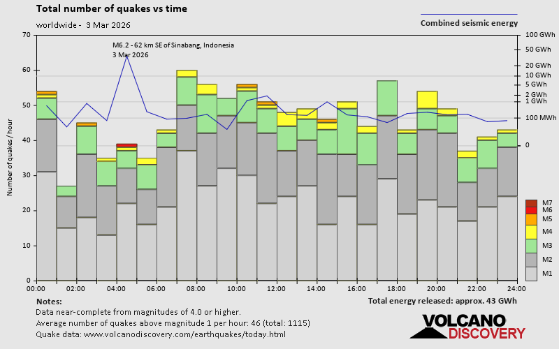 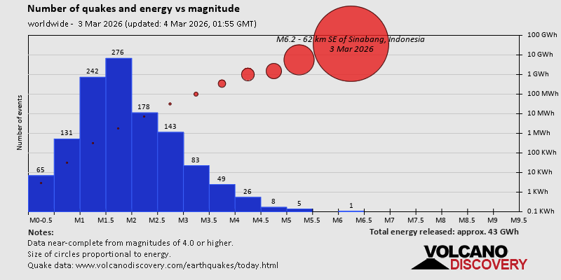 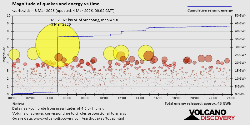 https://www.volcanodiscovery.com/earthquake/news/296498/World-Earthquake-Report-for-Tuesday-3-March-2026.html https://www.volcanodiscovery.com/earthquake/news/296498/World-Earthquake-Report-for-Tuesday-3-March-2026.html
0
7
Read More
|
SPC Mar 3, 2026 1730 UTC Day 2 Convective Outlook
Webmaster
5 hours ago
SPC Mar 3, 2026 1730 UTC Day 2 Convective OutlookSPC 1730Z Day 2 Outlook 
Day 2 Convective Outlook
NWS Storm Prediction Center Norman OK
1126 AM CST Tue Mar 03 2026

Valid 041200Z - 051200Z

...THERE IS A SLIGHT RISK OF SEVERE THUNDERSTORMS FROM NORTH TEXAS
TO THE SOUTHERN MISSOURI AND ILLINOIS...

...SUMMARY...
Isolated to scattered severe thunderstorms are expected during the
afternoon and evening on Wednesday from north-central Texas and
southeast Oklahoma into northwest Arkansas, southeast Missouri and
southern Illinois.  Large hail and occasional wind damage will be
the primary threats.

...Southern Plains to lower OH Valley...
A midlevel shortwave trough now over CO will progress eastward and
reach the mid MS Valley by early Thursday, in response to an
amplifying wave upstream over the Great Basin/CA.  An associated
weak surface wave will develop east-northeastward along a
quasi-stationary baroclinic from the Ozarks to the lower OH Valley,
and this baroclinic zone will serve as the primary focus for ascent
and convection Wednesday into early Thursday. Boundary-layer
dewpoints in the 60s will be prevalent along and south of the front
by tomorrow, given the returning moisture already present from
southeast OK into MS.  The low-level moistening will occur beneath
the eastern extent of an elevated mixed layer with 7-8 C/km midlevel
lapse rates, per 12z soundings across the southern Plains.  Surface
heating in cloud breaks will contribute to MLCAPE near 1000 J/kg
with diminishing convective inhibition along the front through the
afternoon.

Elevated convection could be ongoing at the start of the period
across southeast KS/northeast OK in a zone of low-level warm
advection.  Storms will spread east-northeastward through the day
toward southeast MO/southern IL and vicinity, while additional
storms are probable along the front during the afternoon/evening
from central/north TX into eastern OK/western AR.  Deep-layer and
low-level vertical shear will be sufficient for storm clusters and
some supercell structures by late afternoon/evening closer to the
path of the weak cyclone and midlevel trough across southern MO,
where there will be the potential for large hail, damaging gusts,
and a couple of tornadoes.  Deep-layer shear will be weaker farther
to the southwest toward TX where storms should be more
isolated/discrete with an accompanying threat for large hail.
Convection may persist through the overnight hours to the immediate
cool side of the front.

..Thompson.. 03/03/2026
Read morehttps://www.spc.noaa.gov/products/outlook/day2otlk_1730.html
0
3
Read More
|
|
Forums60
Topics764,303
Posts799,044
Members2,958
| |
Most Online17,963
Jan 15th, 2026
|
|
|
|
|
Copyright 1996 - 2026 by David Cottle. Designed by David Bate Jr. All Rights Reserved.
By using this forum, the user agrees not to transfer any data or technical information received under the agreement, to any other entity without the express approval of the AUS-CITY Forum Admins and/or authors of individual posts (Forum Admins and DoD/USSPACECOM for the analysis of satellite tracking data).
Two-line elements (TLE) and all other satellite data presented and distributed via this forum and e-mail lists of AUS-CITY are distributed with permission from DoD/USSTRATCOM.


Reprise Hosting

|

|


 - Click image for larger picture.")


