|
|
|
0 members (),
2,401
guests, and
24
robots. |
|
Key:
Admin,
Global Mod,
Mod
|
|
S |
M |
T |
W |
T |
F |
S |
|
|
|
|
1
|
2
|
3
|
4
|
|
5
|
6
|
7
|
8
|
9
|
10
|
11
|
|
12
|
13
|
14
|
15
|
16
|
17
|
18
|
|
19
|
20
|
21
|
22
|
23
|
24
|
25
|
|
26
|
27
|
28
|
29
|
30
|
|
|
|
There are no members with birthdays on this day. |
|
|
|
|
|
|
|
|
|
|
|
|
|
|
|
|
SPC MD 387
by Webmaster - Sun 12 Apr 2026 07:21:PM
|
SPC MD 388
by Webmaster - Sun 12 Apr 2026 07:21:PM
|
 SPC MD 387
Webmaster
4 hours ago
SPC MD 387
Webmaster
4 hours ago
SPC MD 387MD 0387 CONCERNING SEVERE POTENTIAL...WATCH UNLIKELY FOR PARTS OF CENTRAL AND SOUTHEASTERN TEXAS 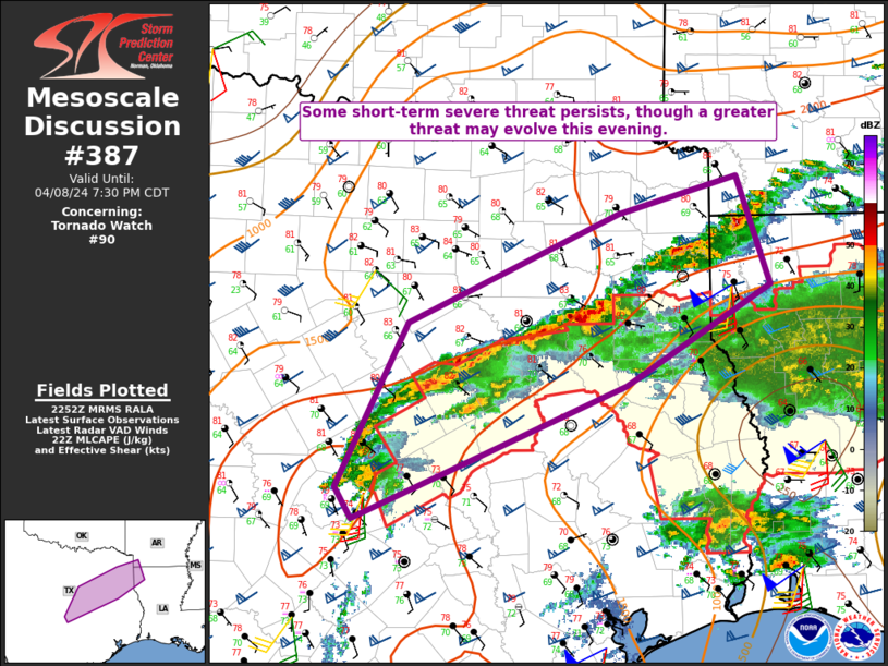
Mesoscale Discussion 0387
NWS Storm Prediction Center Norman OK
1252 PM CDT Sun Apr 12 2026

Areas affected...parts of central and southeastern Texas

Concerning...Severe potential...Watch unlikely

Valid 121752Z - 122015Z

Probability of Watch Issuance...5 percent

SUMMARY...Strong thunderstorm development may persist into the 4-6
PM CDT time frame, perhaps accompanied by some risk for a brief
tornado, and a few strong surface gusts before storms diminish.

DISCUSSION...Moderate southerly return flow persists across the
middle Texas coastal plain, near the southern periphery of a belt of
40-50 kt southwesterly 500 mb flow extending from south of the Texas
Big Bend through the southeastern Great Plains.  One short wave
impulse embedded within this regime now appears to be shifting
across/northwest of the Ark-La-Texas vicinity, with perhaps an even
more subtle perturbation/associated speed maximum still upstream and
forecast to propagate across central Texas through mid to late
afternoon.

Likely aided by inflow of moist boundary-layer characterized by
surface dew points around 70F, which appears to be contributing to
CAPE on the order of 1500 J/kg, vigorous convective development to
the north-northwest of Victoria has been exhibiting transient
supercell structure the past couple of hours.  This appears to
focused near a lingering 30+ kt southerly 850 mb jet axis, which
various model output suggests may still undergo some strengthening
into mid/late afternoon.  As this occurs, the aforementioned
convection and trailing storms developing to the southwest may
undergo further intensification and upscale growth.

This may be accompanied by at least some risk for a brief tornado.
With forecast soundings indicating near saturated profiles through a
fairly deep surface-based layer, the risk for damaging wind gusts
may be initially hindered, but, with time, this potential could
gradually increase with heavy precipitation loading and further
upscale convective growth.

..Kerr/Mosier.. 04/12/2026

...Please see www.spc.noaa.gov for graphic product...

ATTN...WFO...HGX...CRP...EWX...

LAT...LON   28349792 29269779 30349679 30349626 29909574 29159676
            28349792

MOST PROBABLE PEAK TORNADO INTENSITY...UP TO 95 MPH
MOST PROBABLE PEAK WIND GUST...55-70 MPH
MOST PROBABLE PEAK HAIL SIZE...UP TO 1.25 IN
Read morehttps://www.spc.noaa.gov/products/md/md0387.html
0
17
Read More
|
SPC MD 388
Webmaster
4 hours ago
SPC MD 388MD 0388 CONCERNING SEVERE POTENTIAL...WATCH UNLIKELY FOR PORTIONS OF NORTHERN UTAH INTO EASTERN IDAHO...FAR WESTERN WYOMING...EXTREME SOUTHWESTERN MONTANA 
Mesoscale Discussion 0388
NWS Storm Prediction Center Norman OK
0140 PM CDT Sun Apr 12 2026

Areas affected...portions of northern Utah into eastern Idaho...far
western Wyoming...extreme southwestern Montana

Concerning...Severe potential...Watch unlikely

Valid 121840Z - 122045Z

Probability of Watch Issuance...5 percent

SUMMARY...A few severe gusts may occur with the strongest storms
that can mature over the next several hours. The severe threat
should remain isolated.

DISCUSSION...Clearing skies are supporting boundary-layer
mixing/destabilization amid the approach of a 500 mb vort max,
resulting in increased lift for convective development. Visible
satellite imagery depicts deepening CU, with NLDN lightning data
already showing a few lightning flashes in spots. Storms should
continue to increase in coverage and intensity through the afternoon
given 8+ C/km mid-level lapse rates amid 30 kts of effective bulk
shear. Storms should be mainly multicellular, the strongest of which
may be accompanied by occasional strong wind gusts (a few of which
may be severe, especially in higher-terrain areas), and perhaps an
instance or two of hail. Given the modest speed shear, the severe
threat should remain isolated at best, so a WW issuance is not
expected.

..Squitieri/Mosier.. 04/12/2026

...Please see www.spc.noaa.gov for graphic product...

ATTN...WFO...RIW...TFX...SLC...PIH...MSO...BOI...LKN...

LAT...LON   41451373 41571385 42281435 42551434 43131422 44151393
            44961322 45031241 44951142 44651061 44171030 42791005
            41641001 40751026 40321090 40091188 40131251 40511325
            41451373

MOST PROBABLE PEAK WIND GUST...55-70 MPH
MOST PROBABLE PEAK HAIL SIZE...UP TO 1.25 IN
Read morehttps://www.spc.noaa.gov/products/md/md0388.html
0
18
Read More
|
SPC MD 389
Webmaster
4 hours ago
SPC MD 389MD 0389 CONCERNING SEVERE POTENTIAL...WATCH UNLIKELY FOR PARTS OF CENTRAL TEXAS 
Mesoscale Discussion 0389
NWS Storm Prediction Center Norman OK
0219 PM CDT Sun Apr 12 2026

Areas affected...parts of central Texas

Concerning...Severe potential...Watch unlikely

Valid 121919Z - 122115Z

Probability of Watch Issuance...20 percent

SUMMARY...A couple of severe storms with potential to produce severe
hail may gradually develop through 4-6 PM CDT.  It is not yet clear
that a severe weather watch will be needed, but trends will continue
to be monitored for this possibility.

DISCUSSION...Beneath the belt of 40-50 kt southwesterly 500 mb flow
overspreading central Texas, deepening convective development is
evident near and west of the I-35 corridor, from the Hill Country
northward into areas just southwest of the Metroplex.  Forcing for
ascent downstream of a jet streak embedded within this regime may be
aiding development, which appears focused within weak
lower/mid-tropospheric warm advection on the northern/northeastern
periphery of a plume of more strongly capping elevated mixed-layer
air.

Boundary-layer moisture characterized by surface dew points near 70F
appears to be contributing to CAPE in excess of 1500 J/kg, aided by
increasing insolation in the wake of early day convection spreading
northeast and east of the region.  Given the strong deep-layer
shear, it appears that a couple of supercell structures with
potential to produce large hail may develop as scattered storms
initiate over the next few hours.

..Kerr/Mosier.. 04/12/2026

...Please see www.spc.noaa.gov for graphic product...

ATTN...WFO...FWD...EWX...SJT...

LAT...LON   32179832 31869743 30189706 29889828 30429844 31599911
            32179832

MOST PROBABLE PEAK WIND GUST...UP TO 60 MPH
MOST PROBABLE PEAK HAIL SIZE...1.50-2.50 IN
Read morehttps://www.spc.noaa.gov/products/md/md0389.html
0
17
Read More
|
SPC Apr 12, 2026 1730 UTC Day 2 Convective Outlook
Webmaster
6 hours ago
SPC Apr 12, 2026 1730 UTC Day 2 Convective OutlookSPC 1730Z Day 2 Outlook 
Day 2 Convective Outlook
NWS Storm Prediction Center Norman OK
1227 PM CDT Sun Apr 12 2026

Valid 131200Z - 141200Z

...THERE IS AN ENHANCED RISK OF SEVERE THUNDERSTORMS ACROSS PORTIONS
OF CENTRAL/EASTERN MINNESOTA INTO WESTERN/CENTRAL WISCONSIN...

...SUMMARY...
Severe thunderstorms are likely across the Upper Mississippi Valley
and Great Lakes region with potential for large to very large hail,
damaging wind, and tornadoes. A more conditional and isolated risk
for severe storms is possible across portions of the southern Plains
on Monday.

...Synopsis...
A southwesterly flow regime will continue from the southern Plains
to the Upper Midwest on Monday. Low-amplitude upper ridging will
move across the Upper Midwest during the day ahead of a shortwave
trough moving across the northern Plains. The shortwave will shift
east across the Great Lakes overnight. Meanwhile, an upper trough
from the northern Rockies to offshore the southern CA coast will
pivot eastward toward the Four Corners region. At the surface, low
pressure near the SD/NE border will develop east along the MN/IA
border to central WI. Lee troughing will persist across the Plains.
A dryline will extend southwest from the Mid-MO Valley into western
OK/TX, while a warm front extends from southern MN into
southern/central WI. These boundaries will become a focus for severe
thunderstorm development during the afternoon/evening.

...Upper Midwest...
Along and south of the surface warm front across MN into
southern/central WI, strong daytime heating will be occurring amid
dew points in the low to mid 60s. This will yield moderate to strong
instability with MLCAPE around 2000-3000 J/kg. A plume of steep low
to mid-level lapse rates will also impinge upon the region through
the afternoon. Capping will likely suppress thunderstorm activity
for much of the day as the shortwave upper ridge moves across the
region. By the late afternoon/early evening, a shortwave trough will
overspread the region with an increase in the low-level jet.
Thunderstorm activity is expected to develop, with initially
elevated supercells likely given strong deep layer shear and
thermodynamic profiles. These will be capable of large to very large
hail (some 2-3+ inches in diameter). Should any supercells be able
to anchor to the warm front and become surface based, the threat for
a tornado or two (possibly strong) will increase given large
clockwise curved hodographs indicative of favorable low-level shear.
An Enhanced Risk was included with this outlook driven by the hail
potential. Convection will spread eastward with time into MI,
continuing to pose a risk for hail overnight.

...Central/Southern Plains....
A conditional severe risk will extend further down the dryline into
the central/southern Plains for the afternoon/evening. Strong
daytime heating will yield very warm temperatures ahead of the
dryline but most convective temperatures are near or exceeding 90F.
Forecast soundings indicate strong capping in place across much of
the region through the afternoon with generally weak forcing for
ascent outside of the dryline circulation, which will likely inhibit
a more widespread severe risk. Nonetheless, moderate to strong
instability will overlap increasing deep layer shear as the
low-level jet increases through the evening. An isolated supercell
threat will be possible along the dryline, with greater confidence
along the Red River in northern TX/southwestern OK and further south
into Texas near the Rio Grande Valley. Should supercells develop,
the main risk will be for large to very large hail (some 2+ inches
in diameter).

..Thornton.. 04/12/2026
Read morehttps://www.spc.noaa.gov/products/outlook/day2otlk_1730.html
0
17
Read More
|
SPC Apr 12, 2026 1630 UTC Day 1 Convective Outlook
Webmaster
7 hours ago
SPC Apr 12, 2026 1630 UTC Day 1 Convective OutlookSPC 1630Z Day 1 Outlook 
Day 1 Convective Outlook
NWS Storm Prediction Center Norman OK
1129 AM CDT Sun Apr 12 2026

Valid 121630Z - 131200Z

...THERE IS A SLIGHT RISK OF SEVERE THUNDERSTORMS ACROSS PORTIONS OF
SOUTHWEST AND CENTRAL TX...

...SUMMARY...
Isolated to scattered severe thunderstorms are possible today into
evening mainly across parts of Texas and perhaps other nearby parts
of the southern Plains. More isolated severe storms may occur across
portions of the Upper Great Lakes and northern Rockies.

...Synopsis...
Recent satellite imagery shows a pair of phased shortwave troughs
over the Plains, one moving through the Dakotas and another moving
through KS/OK. Both of these waves are forecast to continue
northeastward through the day, with the northern wave reaching
northwestern Ontario and the southern wave reaching the Great Lakes
region. This evolution will take these waves east/northeast of the
higher low-level moisture, which will remain in a corridor from the
southern Plains northeastward into the Upper Midwest. Showers and
thunderstorms are anticipated throughout much of this corridor
today, with highest thunderstorm chances across central/east TX and
from the Upper Midwest into the Great Lakes.

Farther west, an upper low is slowly drifting eastward across
northern CA. Guidance suggests this eastward drift will continue
today, with several shortwave troughs rotating quickly through the
base of this system and ejecting across the Great Basin and northern
Rockies. Large-scale ascent and modest mid-level moisture associated
with these waves will combine with cold temperatures aloft and
associated buoyancy to support thunderstorms today from northern CA
across the northern Great Basin and northern Rockies, and into the
northern Plains.

...Southern/Central Plains...
Much of this region will be displaced south and west of any notable
large-scale forcing for ascent. This limited ascent, combined with
the showers and isolated thunderstorms currently ongoing across
central and east TX, complicates the overall forecast today, with
mesoscale factors likely contributing significantly to when and
where storms develop this afternoon and evening. General expectation
is for development along the southern and western periphery on the
ongoing storms (i.e. from southeast/south-central TX into southwest
TX) later this afternoon and this evening. This redevelopment will
be supported by a combination of moist advection, modest heating,
and limited low-level convergence. Moderate to strong buoyancy amid
moderate vertical shear could support supercells if the mode remains
discrete. However, the weakness in the mid-level flow suggests
storms may tend to cluster, a scenario that is supported by most CAM
guidance. Buoyancy and shear are still strong enough to support
rotating updrafts and large hail early in the convective cycle, but
the trends towards a messy convective mode could limit the
persistence and coverage of robust updrafts. Damaging gusts are
possible even with the clustered storm mode, especially given there
is some potential for slightly more organized bowing segments over
time.

Farther west, mid-level height rises/subsidence are anticipated
coincident with the dryline from central Kansas south-southwestward
across western Oklahoma and west/southwest Texas. The environment,
characterized by 1500 to 2000 J/kg of MLCAPE and 30 to 40 kt of
westerly deep-layer shear, is conditionally supportive of supercells
capable of all severe hazards. However, the previously mentioned
height rises and subsidence, combined with modest convective
inhibition, are generally expected to preclude thunderstorm
development. Even so, given the conditional risk, Marginal risk
probabilities will be maintained.

...Minnesota/Wisconsin...
Recent surface analysis places a low just west of FAR, with a warm
front extending southwestward across central/southeast MN and
southern WI. This low is forecast to move eastward today, while the
warm front expands northward. A narrow corridor of surface-based
buoyancy could develop from north-central MN into far northwest WI
as dewpoints increase in the upper 50s (perhaps even low 60s).
Thunderstorm initiation appears possible along the cold front within
this corridor, although veered low-level flow and northward/westward
displacement of the better forcing casts doubt to whether updrafts
will be maintained. Any storms that do mature within this warm
sector should become supercells capable of all severe hazards,
including large hail and tornadoes. However, low confidence in storm
development and maturity precludes higher probabilities with this
outlook.

...Northern Rockies...
Mid-level moisture will support another day of modest surface-based
buoyancy ahead of the shortwave trough mentioned in the synopsis.
Persistent 30-40 knot flow within the CAPE-bearing layer combined
with somewhat deep boundary-layer mixing will support strong to
severe downburst winds with the more robust convective cells, mainly
this afternoon through early evening.

..Mosier/Squitieri.. 04/12/2026
Read morehttps://www.spc.noaa.gov/products/outlook/day1otlk_1630.html
0
16
Read More
|
SPC Day 1 Fire Weather Outlook
Webmaster
7 hours ago
SPC Day 1 Fire Weather OutlookSPC Day 1 Fire Weather Outlook 
Day 1 Fire Weather Outlook
NWS Storm Prediction Center Norman OK
1119 AM CDT Sun Apr 12 2026

Valid 121700Z - 131200Z

...Central Plains...
Dry and breezy conditions in the wake of a departing surface low are
still expected across southeastern WY into southern ND and much of
northwestern NE through this afternoon. West winds of 15-20 mph
along with relative humidity in the 15-20% range will support
elevated fire weather conditions as far east as the Sioux Falls area
based on latest model guidance, where an eastward expansion of
Elevated highlights was appropriate.

...Southeast and Appalachians...
A tightening surface pressure gradient between the low entering the
Upper Midwest and high pressure sliding eastward off the
Mid-Atlantic Coast, will support steady south/southwest sustained
winds of around 10 mph (locally 15 mph) across much of the Southeast
and Appalachians through today. A relatively dry air mass remains in
place with RH falling to as low as 20% during peak afternoon
heating. Fuels remain exceptionally dry and receptive to wildfire
spread with ERC values reaching into the 95th to 99th percentiles
amid an expanding drought. The increased south/southwest flow and
low afternoon RH will support a broad area of elevated fire weather
conditions from the mid MS River Valley to the OH River Valley. An
eastward expansion of Elevated highlights into portions WV, southern
Appalachians and northern GA was warranted based on latest near term
model guidance.

See previous discussion for additional forecast details.

..Williams.. 04/12/2026

.PREV DISCUSSION... /ISSUED 0159 AM CDT Sun Apr 12 2026/

...Synopsis...
Broad and intensifying southwest flow aloft and an intensifying
surface cyclone progressing from the northern plains into the upper
Midwest will be responsible for widespread dry and windy conditions
across much of the southwestern U.S. into the Great Plains this
afternoon.

...Southwest and Four Corners...
Deeply mixed and dry boundary layer profiles will support strong
southwesterly surface winds across much of the Southwest into the
Four Corners region, reaching 20 MPH (gusting 25-30 in some regions)
with widespread relative humidity of 10-15%. These conditions will
coincide with a wide array of fuel conditions ranging from
marginally to modestly receptive. Locally Critical conditions may
occur, with some signal for a corridor of stronger winds in
south-central Utah. However, overall marginal fuels and lack of
confidence in the duration and magnitude of surface winds reaching
Critical criteria preclude highlights at this time.

...Central High Plains...
Surface conditions behind the dryline in the Central High Plains
will be quite gusty and dry, with winds of 20-25 MPH and relative
humidity as low as 10% across much of the region. However, these
conditions overlap a complex fuelsape where recent showers and
thunderstorms have dampened fuels across portions of
central/southern Colorado into New Mexico. Further north into
portions of Wyoming and Nebraska, where fuels are more receptive,
winds are expected to remain at or around 20 MPH, with gusts
exceeding 25 MPH. Locally critical conditions may occur in portions
of northern Nebraska.

...Ohio River Valley/Middle Mississippi Valley...
Ongoing drought conditions coupled with dry and breezy southerly
flow will result in Elevated fire-weather concerns across portions
of the Mississippi Valley into the Ohio River Valley. Surface winds
of 10-15 MPH and relative humidity of 25-35% will overlap with fuels
exceeding the 95th-99th annual ERC percentiles.

...Please see www.spc.noaa.gov/fire for graphic product...
Read morehttps://www.spc.noaa.gov/products/fire_wx/fwdy1.html
0
16
Read More
|
World Earthquake Report for Sunday, 12 April 2026
Webmaster
11 hours ago
World Earthquake Report for Sunday, 12 April 2026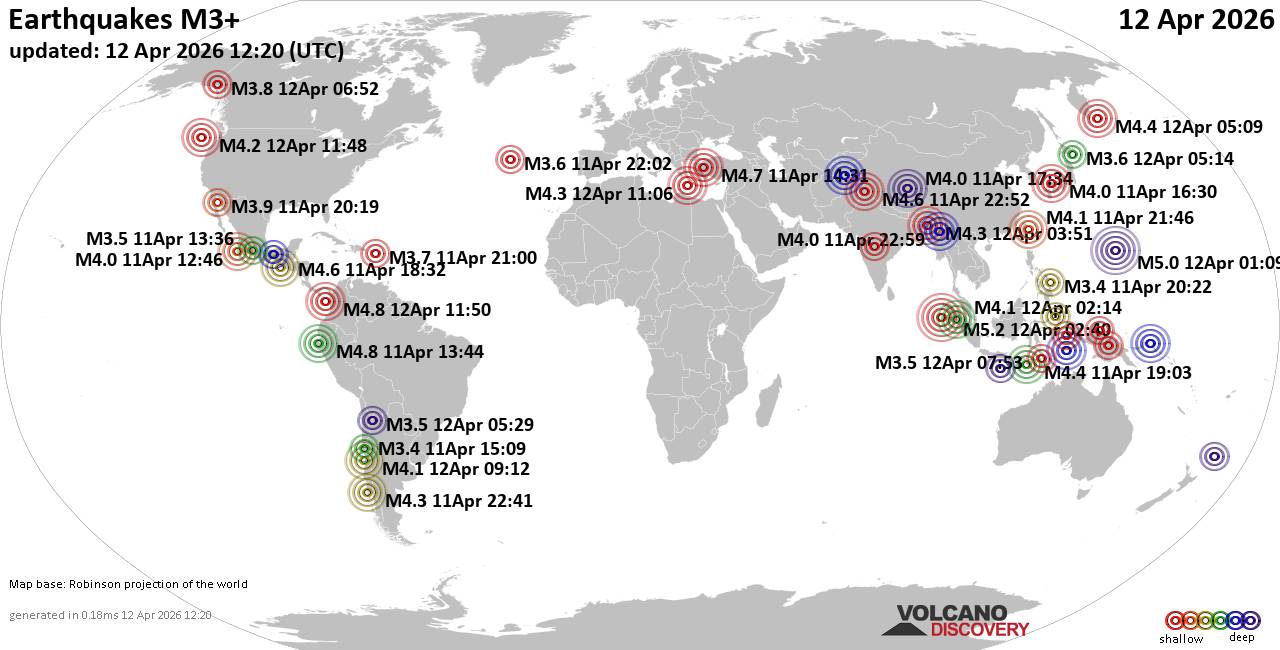 Worldwide earthquakes above magnitude 3 during the past 24 hours on 12 Apr 2026 Magnitude 5+: 2 earthquakes Magnitude 4+: 31 earthquakes Magnitude 3+: 157 earthquakes Magnitude 2+: 415 earthquakes No quakes of magnitude 6 or higher 10 largest earthquakes in the world (past 24 hours)Sunday, Apr 12, 2026, at 08:40 am (GMT +6) - Sunday, Apr 12, 2026, at 11:09 am (GMT +10) - Sunday, Apr 12, 2026, at 06:50 am (GMT -5) - Saturday, Apr 11, 2026, at 08:44 am (GMT -5) - Saturday, Apr 11, 2026, at 05:31 pm (GMT +3) - Saturday, Apr 11, 2026, at 12:32 pm (GMT -6) - Sunday, Apr 12, 2026, at 04:22 am (GMT +5:30) - Sunday, Apr 12, 2026, at 05:21 am (GMT +8) - Sunday, Apr 12, 2026, at 04:29 am (GMT +4:30) - Sunday, Apr 12, 2026, at 05:09 pm (Kamchatka time) - Earthquakes reported feltSunday, Apr 12, 2026, at 09:21 am (GMT +5:30) - Saturday, Apr 11, 2026, at 05:31 pm (GMT +3) - Saturday, Apr 11, 2026, at 06:41 pm (GMT -4) - Saturday, Apr 11, 2026, at 09:53 pm (GMT -6) - Sunday, Apr 12, 2026, at 04:22 am (GMT +5:30) - Sunday, Apr 12, 2026, at 04:37 am (Kolkata time) - Sunday, Apr 12, 2026, at 04:00 am (GMT -4) - Saturday, Apr 11, 2026, at 10:01 pm (GMT -6) - Sunday, Apr 12, 2026, at 09:34 am (GMT +3) - Sunday, Apr 12, 2026, at 08:40 am (GMT +6) - Saturday, Apr 11, 2026, at 12:32 pm (GMT -6) - Sunday, Apr 12, 2026, at 03:03 am (GMT +8) - Saturday, Apr 11, 2026, at 08:44 am (GMT -5) - Saturday, Apr 11, 2026, at 05:00 pm (GMT -4) - Sunday, Apr 12, 2026, at 12:51 am (Kolkata time) - Saturday, Apr 11, 2026, at 11:12 am (GMT -7) - Sunday, Apr 12, 2026, at 04:12 am (GMT -7) - Saturday, Apr 11, 2026, at 07:11 pm (GMT +3) - Sunday, Apr 12, 2026, at 05:12 am (GMT -4) - Saturday, Apr 11, 2026, at 05:42 pm (GMT +3) - Earthquake stats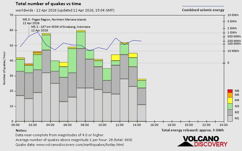 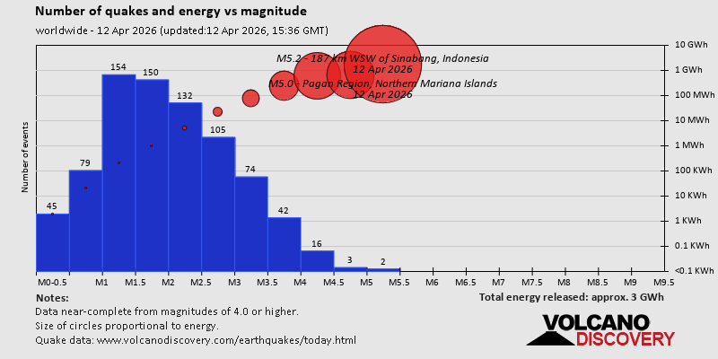 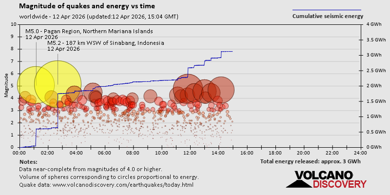 https://www.volcanodiscovery.com/earthquake/news/299788/World-Earthquake-Report-for-Sunday-12-April-2026.html https://www.volcanodiscovery.com/earthquake/news/299788/World-Earthquake-Report-for-Sunday-12-April-2026.html
0
28
Read More
|
Volcano earthquake report for Sunday, 12 Apr 2026
Webmaster
11 hours ago
Volcano earthquake report for Sunday, 12 Apr 2026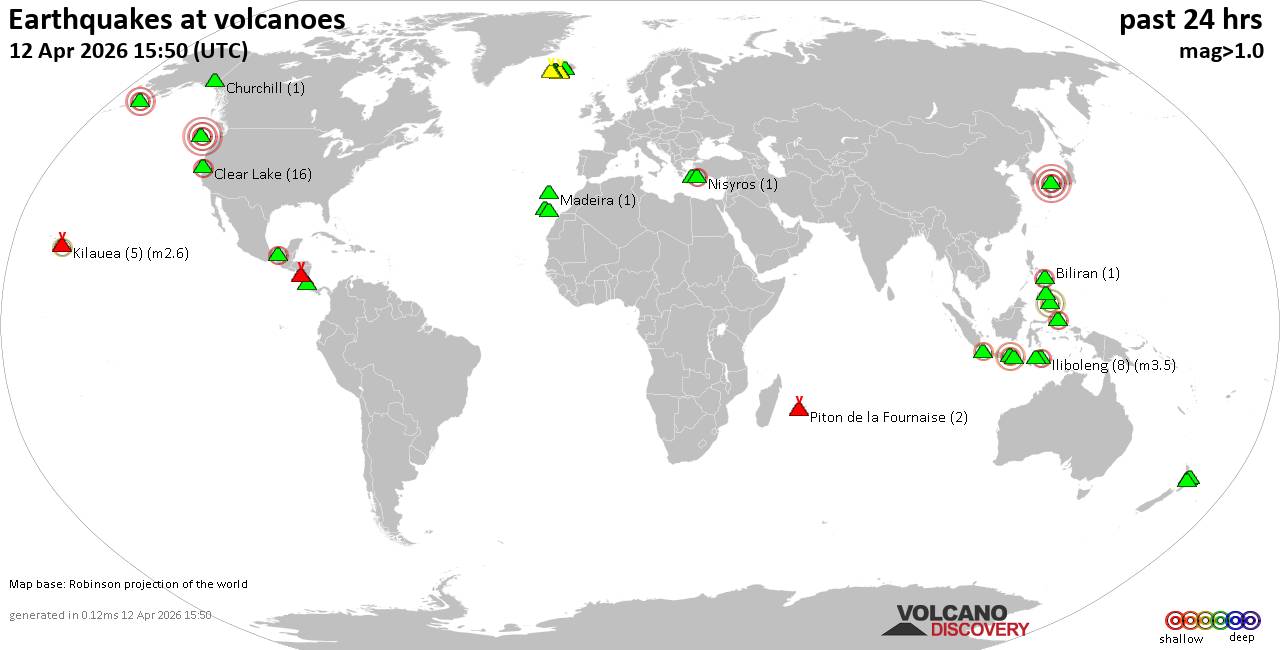 World map showing volcanoes with shallow (less than 50 km) earthquakes within 20 km radius during the past 24 hours on 12 Apr 2026 Number in brackets indicate nr of quakes. Quakes detected near: Baluran (2 quakes between mag 2.8-3.2), Bardarbunga (4 quakes between mag 1.1-1.6), Barva (4 quakes between mag 1.8-2.7), Biliran (1 quake mag 2.5), Brennisteinsfjöll (3 quakes between mag 0.2-1.1), Churchill (1 quake mag 1.0)
Clear Lake (17 quakes between mag 0.4-2.3), Cobb Segment (5 quakes between mag 2.9-3.7), El Chichón (2 quakes between mag 2.3-2.4), Etna (1 quake mag 1.1), Eyafjallajökull (1 quake mag 1.5), Gagak (1 quake mag 2.1), Grímsnes (14 quakes between mag 0.0-1.6), Hekla (1 quake mag 1.0), Iliboleng (8 quakes between mag 2.1-3.5), Jailolo (2 quakes between mag 2.1-2.2), Katla (10 quakes between mag 0.0-1.4), Kilauea (5 quakes between mag 1.7-2.6), Kolumbo (1 quake mag 1.2), La Palma (1 quake mag 1.8), Latukan (2 quakes between mag 1.6-2.2), Madeira (1 quake mag 1.4), Mammoth Mountain (1 quake mag 1.3), Maroa (5 quakes between mag 1.6-2.4), Masaya (6 quakes between mag 1.1-3.1), Nisyros (1 quake mag 2.0), Okataina (Tarawera) (1 quake mag 2.5), Piton de la Fournaise (3 quakes between mag 0.3-1.5), Sanbe (1 quake mag 4.0), Svartsengi (1 quake mag 1.0), Tenerife (11 quakes between mag 1.0-2.0), Tjörnes Fracture Zone (3 quakes between mag 0.6-1.4), Torfajökull (3 quakes between mag 0.9-1.0) (updated 11h50)
Note: Earthquakes within 20 km from and at depths less than 50 km under active volcanoes are reported. The list is not complete because many volcanoes are not monitored and/or seismic data in high resolution is not available publicly.
Volcanoes with recent earthquakes above magnitude 2 or more than 10 quakes are listed below:
Baluran volcano (East Java): 2 earthquakes up to magnitude 3.22 earthquakes occurred near (under) the volcano during 1 hour 22 minutes, the last being recorded quake 10 hours ago. Hypocenter depths ranged between 25.00 and 17.00 km. Earthquake details: 3.2 quake Kabupaten Situbondo, 19 km north of Wongsorejo, Indonesia, Apr 12, 2026 09:04 am (GMT +7) (6 km NE) 2.8 quake Kabupaten Situbondo, 17 km north of Wongsorejo, Indonesia, Apr 12, 2026 07:43 am (GMT +7) (1 km N) All earthquakes at BaluranBarva volcano (Costa Rica): 4 earthquakes up to magnitude 2.74 earthquakes occurred near (under) the volcano during 14 hours, the last being recorded quake 4 hours ago. Hypocenter depths ranged between 13.00 and 0.00 km. Earthquake details: 2.7 quake Provincia de Heredia, 27 km northeast of San Jose, Costa Rica, Apr 12, 2026 01:42 am (GMT -6) (14 km ENE) 2.4 quake Provincia de Heredia, 27 km northeast of San Jose, Costa Rica, Apr 11, 2026 11:42 am (Costa_Rica time) (13 km E) 1.8 quake Provincia de Heredia, 27 km north of San Jose, Provincia de San Jose, Costa Rica, Apr 12, 2026 01:43 am (Costa_Rica time) (12 km E) 1.8 quake 28 km northeast of San Jose, Provincia de San Jose, Costa Rica, Apr 11, 2026 12:18 pm (Costa_Rica time) (14 km E) All earthquakes at BarvaBiliran volcano (Central Philippines): magnitude 2.5 earthquakeA magnitude 2.5 earthquake occurred at the volcano 9 hours ago. The quake, which might be volcanic in origin, was located at a depth of 26.00 km depth at 8 km distance W from the volcano. Earthquake details: 2.5 quake 8.2 km southeast of Naval, Biliran, Eastern Visayas, Philippines, Apr 12, 2026 11:12 am (GMT +8) (8 km W) All earthquakes at BiliranClear Lake volcano (California): 17 earthquakes up to magnitude 2.3Possible earthquake swarm: 17 earthquakes occurred near (under) the volcano during 21 hours, the last being recorded quake 1 hour 12 minutes ago. Hypocenter depths ranged between 3.82 and 0.33 km. Earthquake details: (only 5 largest) 2.3 quake 12 mi southwest of Clearlake, Lake County, California, United States, Apr 12, 2026 02:25 am (GMT -7) (15 km S) 1.6 quake Sonoma County, 13 mi southwest of Clearlake, Lake County, California, United States, Apr 11, 2026 11:53 am (GMT -7) (19 km S) 1.3 quake 25 mi north of Santa Rosa, Sonoma County, California, United States, Apr 11, 2026 04:10 pm (GMT -7) (19 km S) 1.2 quake 27 mi north of Santa Rosa, Sonoma County, California, United States, Apr 11, 2026 07:01 am (GMT -7) (18 km SSW) 1.2 quake 27 mi north of Santa Rosa, Sonoma County, California, United States, Apr 11, 2026 11:28 pm (GMT -7) (17 km SSW) All earthquakes at Clear LakeCobb Segment volcano (Northern Pacific Ocean): 5 earthquakes up to magnitude 3.75 earthquakes occurred near (under) the volcano during 1 hour 17 minutes, the last being recorded quake 2 hours ago. Hypocenter depths ranged between 10.00 and 10.00 km. Earthquake details: 3.7 quake North Pacific Ocean, 364 km southwest of Tofino, Regional District of Alberni-Clayoquot, British Columbia, Canada, Apr 12, 2026 12:47 am (GMT -9) (6 km SSW) 3.0 quake Off the Coast of Washington Apr 11, 2026 11:59 pm (GMT -9) (19 km WSW) 3.0 quake Off the Coast of Washington Apr 11, 2026 11:30 pm (GMT -9) (4 km NE) 2.9 quake Off the Coast of Washington Apr 12, 2026 12:07 am (GMT -9) (16 km E) 2.9 quake Off the Coast of Washington Apr 11, 2026 11:49 pm (GMT -9) (11 km E) All earthquakes at Cobb SegmentEl Chichón volcano (Southern Mexico): 2 earthquakes up to magnitude 2.42 earthquakes occurred near (under) the volcano during 6 hours, the last being recorded quake 15 hours ago. Hypocenter depths ranged between 9.00 and 2.80 km. Earthquake details: 2.4 quake Estado de Chiapas, 37 km southwest of Teapa, Estado de Tabasco, Mexico, Apr 11, 2026 02:37 pm (GMT -6) (1 km NW) 2.3 quake Estado de Chiapas, 33 km southwest of Teapa, Estado de Tabasco, Mexico, Apr 11, 2026 08:17 am (GMT -6) (4 km NNE) All earthquakes at El ChichónGagak volcano (West Java): magnitude 2.1 earthquakeA magnitude 2.1 earthquake occurred at the volcano 8 hours ago. The quake, which might be volcanic in origin, was located at a depth of 23.00 km depth at 4 km distance NE from the volcano. Earthquake details: 2.1 quake Bogor Regency, 15 km northwest of Cicurug, Indonesia, Apr 12, 2026 10:47 am (GMT +7) (4 km NE) All earthquakes at GagakGrímsnes volcano (Iceland): 14 earthquakes up to magnitude 1.6Possible earthquake swarm: 14 earthquakes occurred near (under) the volcano during 1 hour 4 minutes, the last being recorded quake 28 minutes ago. Hypocenter depths ranged between 5.10 and 0.00 km. Earthquake details: (only 5 largest) 1.6 quake 6.6 km NW of Þjórsárbrú Apr 12, 2026 10:41 am (Universal Time) (9 km SE) 1.6 quake Iceland: 6.5 km NW of Þjórsárbrú Apr 12, 2026 10:45 am (Reykjavik time) (9 km SE) 1.4 quake Iceland: 5.4 km WNW of Þjórsárbrú Apr 12, 2026 10:35 am (Reykjavik time) (10 km SE) 1.3 quake Iceland: 7.0 km WNW of Þjórsárbrú Apr 12, 2026 10:17 am (Reykjavik time) (9 km SSE) 1.2 quake 6.7 km NW of Þjórsárbrú Apr 12, 2026 10:47 am (Universal Time) (9 km SE) All earthquakes at GrímsnesIliboleng volcano (Lesser Sunda Islands): 8 earthquakes up to magnitude 3.58 earthquakes occurred near (under) the volcano during 22 hours, the last being recorded quake 45 minutes ago. Hypocenter depths ranged between 7.00 and 3.00 km. Earthquake details: (only 5 largest) 3.5 quake Kabupaten Flores Timur, 33 km west of Lewoleba, Indonesia, Apr 12, 2026 03:53 pm (GMT +8) (15 km W) 2.9 quake Kabupaten Flores Timur, 32 km west of Lewoleba, Indonesia, Apr 11, 2026 08:42 pm (GMT +8) (17 km SW) 2.8 quake Kabupaten Flores Timur, 27 km west of Lewoleba, Indonesia, Apr 12, 2026 03:10 pm (GMT +8) (11 km WSW) 2.4 quake Kabupaten Flores Timur, 32 km west of Lewoleba, Indonesia, Apr 12, 2026 11:00 am (GMT +8) (17 km SW) 2.4 quake Savu Sea, 16 km south of Pulau Adonara Island, East Nusa Tenggara, Indonesia, Apr 12, 2026 05:10 am (GMT +8) (16 km SSW) All earthquakes at IlibolengJailolo volcano (Halmahera): 2 earthquakes up to magnitude 2.22 earthquakes occurred near (under) the volcano during 4 hours, the last being recorded quake 12 hours ago. Hypocenter depths ranged between 9.00 and 6.00 km. Earthquake details: 2.2 quake Kabupaten Halmahera Barat, 34 km north of Ternate, Indonesia, Apr 12, 2026 05:22 am (GMT +9) (9 km E) 2.1 quake Kabupaten Halmahera Barat, 40 km north of Ternate, Indonesia, Apr 12, 2026 09:00 am (GMT +9) (9 km NE) All earthquakes at JailoloKilauea volcano (Hawai'i (Big Island)): 5 earthquakes up to magnitude 2.65 earthquakes occurred near (under) the volcano during 5 hours, the last being recorded quake 14 hours ago. Hypocenter depths ranged between 29.17 and 5.90 km. Earthquake details: 2.6 quake 35 mi southwest of Hilo, Hawaii County, Hawaii, United States, Apr 11, 2026 11:49 am (GMT -10) (16 km SW) 2.6 quake 36 mi southwest of Hilo, Hawaii County, Hawaii, United States, Apr 11, 2026 11:49 am (GMT -10) (18 km SW) 1.7 quake 36 mi southwest of Hilo, Hawaii County, Hawaii, United States, Apr 11, 2026 08:35 am (GMT -10) (17 km SW) 1.7 quake 36 mi southwest of Hilo, Hawaii County, Hawaii, United States, Apr 11, 2026 08:03 am (GMT -10) (17 km SW) 1.7 quake 28 mi southwest of Hilo, Hawaii County, Hawaii, United States, Apr 11, 2026 06:43 am (GMT -10) (18 km WNW) All earthquakes at KilaueaLatukan volcano (Mindanao): 2 earthquakes up to magnitude 2.22 earthquakes occurred near (under) the volcano during 7 minutes, the last being recorded quake 18 hours ago. Hypocenter depths ranged between 8.00 and 8.00 km. Earthquake details: 2.2 quake 44 km north of Midsayap, Cotabato, Soccsksargen, Philippines, Apr 12, 2026 01:44 am (GMT +8) (8 km SSE) 1.6 quake 41 km north of Midsayap, Cotabato, Soccsksargen, Philippines, Apr 12, 2026 01:51 am (GMT +8) (11 km SSE) All earthquakes at LatukanMaroa volcano (New Zealand): 5 earthquakes up to magnitude 2.45 earthquakes occurred near (under) the volcano during 3 hours, the last being recorded quake 19 hours ago. Hypocenter depths ranged between 4.70 and 3.60 km. Earthquake details: 2.4 quake 18 km northeast of Taupo, Waikato, New Zealand, Apr 12, 2026 02:17 am (GMT +12) (16 km SE) 2.0 quake 19 km northeast of Taupo, Waikato, New Zealand, Apr 12, 2026 01:24 am (GMT +12) (15 km SE) 1.7 quake 19 km northeast of Taupo, Waikato, New Zealand, Apr 12, 2026 04:25 am (GMT +12) (17 km SE) 1.6 quake 18 km northeast of Taupo, Waikato, New Zealand, Apr 12, 2026 01:42 am (GMT +12) (16 km SE) 1.6 quake 18 km northeast of Taupo, Waikato, New Zealand, Apr 12, 2026 01:23 am (GMT +12) (17 km SE) All earthquakes at MaroaMasaya volcano (Nicaragua): 6 earthquakes up to magnitude 3.16 earthquakes occurred near (under) the volcano during 1 hour 5 minutes, the last being recorded quake 7 hours ago. Hypocenter depths ranged between 16.00 and 4.00 km. Earthquake details: (only 5 largest) 3.1 quake 2.6 km west of Masaya, Departamento de Masaya, Nicaragua, Apr 11, 2026 09:53 pm (GMT -6) (5 km ESE) 2.4 quake 10.6 km south of Masaya, Departamento de Masaya, Nicaragua, Apr 11, 2026 10:01 pm (GMT -6) (12 km SSE) 1.8 quake 3 km west of Masaya, Departamento de Masaya, Nicaragua, Apr 11, 2026 10:33 pm (GMT -6) (4 km E) 1.7 quake 4.5 km west of Masaya, Departamento de Masaya, Nicaragua, Apr 11, 2026 09:55 pm (GMT -6) (3 km SE) 1.4 quake 2.3 km west of Masaya, Departamento de Masaya, Nicaragua, Apr 11, 2026 10:02 pm (GMT -6) (5 km ESE) All earthquakes at MasayaOkataina (Tarawera) volcano (New Zealand): magnitude 2.5 earthquakeA magnitude 2.5 earthquake occurred at the volcano 9 hours ago. The quake, which might be volcanic in origin, was located at a depth of 5.00 km depth at 15 km distance ESE from the volcano. Earthquake details: 2.5 quake 36 km east of Rotorua, Bay of Plenty, New Zealand, Apr 12, 2026 02:38 pm (GMT +12) (15 km ESE) All earthquakes at Okataina (Tarawera)Sanbe volcano (Honshu): magnitude 4.0 earthquakeA magnitude 4.0 earthquake occurred at the volcano 19 hours ago. The quake, which might be volcanic in origin, was located at a depth of 10.00 km depth at 8 km distance ESE from the volcano. Earthquake details: 4.0 quake 30 km south of Izumo, Shimane, Japan, Apr 12, 2026 01:30 am (GMT +9) (8 km ESE) All earthquakes at SanbeTenerife volcano (Canary Islands): 11 earthquakes up to magnitude 2.0Possible earthquake swarm: 11 earthquakes occurred near (under) the volcano during 3 hours, the last being recorded quake 17 hours ago. Hypocenter depths ranged between 10.00 and 2.00 km. Earthquake details: (only 5 largest) 2.0 quake 8.4 km southeast of La Orotava, Santa Cruz de Tenerife, Canary Islands, Spain, Apr 11, 2026 07:55 pm (GMT +1) (18 km ENE) 1.6 quake 8.3 km southeast of La Orotava, Santa Cruz de Tenerife, Canary Islands, Spain, Apr 11, 2026 07:08 pm (GMT +1) (17 km ENE) 1.6 quake 7.9 km southeast of La Orotava, Santa Cruz de Tenerife, Canary Islands, Spain, Apr 11, 2026 06:41 pm (GMT +1) (17 km ENE) 1.6 quake 8.3 km southeast of La Orotava, Santa Cruz de Tenerife, Canary Islands, Spain, Apr 11, 2026 05:59 pm (GMT +1) (17 km ENE) 1.3 quake 7.6 km southeast of La Orotava, Santa Cruz de Tenerife, Canary Islands, Spain, Apr 11, 2026 07:57 pm (GMT +1) (19 km ENE) All earthquakes at Tenerifehttps://www.volcanodiscovery.com/earthquakes-volcanoes/news/299779/Volcano-earthquake-report-for-Sunday-12-Apr-2026.html
0
23
Read More
|
|
Forums60
Topics768,801
Posts803,567
Members2,958
| |
Most Online17,963
Jan 15th, 2026
|
|
|
|
|
Copyright 1996 - 2026 by David Cottle. Designed by David Bate Jr. All Rights Reserved.
By using this forum, the user agrees not to transfer any data or technical information received under the agreement, to any other entity without the express approval of the AUS-CITY Forum Admins and/or authors of individual posts (Forum Admins and DoD/USSPACECOM for the analysis of satellite tracking data).
Two-line elements (TLE) and all other satellite data presented and distributed via this forum and e-mail lists of AUS-CITY are distributed with permission from DoD/USSTRATCOM.


Reprise Hosting

|

|


 - Click image for larger picture.")


