|
|
|
0 members (),
1,791
guests, and
25
robots. |
|
Key:
Admin,
Global Mod,
Mod
|
|
S |
M |
T |
W |
T |
F |
S |
|
|
|
|
1
|
2
|
3
|
4
|
|
5
|
6
|
7
|
8
|
9
|
10
|
11
|
|
12
|
13
|
14
|
15
|
16
|
17
|
18
|
|
19
|
20
|
21
|
22
|
23
|
24
|
25
|
|
26
|
27
|
28
|
29
|
30
|
|
|
|
There are no members with birthdays on this day. |
|
|
|
|
SPC MD 376
by Webmaster - Fri 10 Apr 2026 09:52:PM
|
SPC MD 374
by Webmaster - Fri 10 Apr 2026 09:52:PM
|
SPC MD 375
by Webmaster - Fri 10 Apr 2026 09:52:PM
|
|
|
|
|
|
|
|
|
|
|
 SPC MD 376
Webmaster
1 hour ago
SPC MD 376
Webmaster
1 hour ago
SPC MD 376MD 0376 CONCERNING SEVERE POTENTIAL...WATCH UNLIKELY FOR EASTERN NEW MEXICO INTO THE TEXAS/OKLAHOMA PANHANDLES 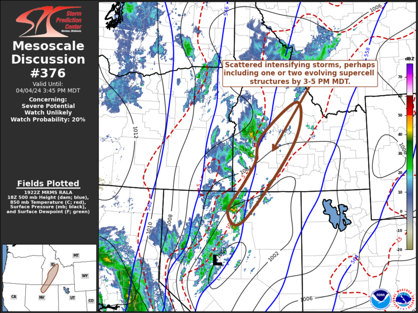
Mesoscale Discussion 0376
NWS Storm Prediction Center Norman OK
0451 PM CDT Fri Apr 10 2026

Areas affected...Eastern New Mexico into the Texas/Oklahoma
Panhandles

Concerning...Severe potential...Watch unlikely

Valid 102151Z - 102345Z

Probability of Watch Issuance...20 percent

SUMMARY...Marginally severe thunderstorms across portions of eastern
New Mexico into the Texas and Oklahoma Panhandles will persist late
this afternoon into the evening hours. These storms will primarily
be capable of damaging wind gusts and 1.00-1.25 inch hail. No
weather watch issuance is anticipated at this time.

DISCUSSION...Thunderstorms have developed in the vicinity and south
of a surface cold front currently oriented east-west across portions
of the Oklahoma and Texas Panhandles. Storms along and immediately
south of the boundary will have support for at least some convective
organization due to modest deep-layer shear of 35-40 kts, while
further to the south and into eastern New Mexico, storms have
primarily developed in deep/dry boundary layers with steep low-level
lapse rates. All storms will be capable of some severe wind gusts
and 1.00-1.25 in hail, with the greatest threat for organized severe
storms being along and immediately south of the surface cold front.
Thunderstorms in the deep/dry boundary layers further south are more
likely to remain disorganized, but are capable of downbursts owing
to the steep low-level lapse rates and tall LCL heights in excess of
2 km. No WW issuance is anticipated at this time.

..Halbert/Thompson.. 04/10/2026

...Please see www.spc.noaa.gov for graphic product...

ATTN...WFO...LUB...AMA...MAF...ABQ...EPZ...

LAT...LON   35130532 35530527 36070488 36450336 36650154 36560058
            36370020 35860023 35340101 34520268 33970339 33270399
            32970463 32940513 33290552 33700550 34060547 35130532

MOST PROBABLE PEAK WIND GUST...UP TO 60 MPH
MOST PROBABLE PEAK HAIL SIZE...UP TO 1.25 IN
Read morehttps://www.spc.noaa.gov/products/md/md0376.html
0
9
Read More
|
SPC MD 374
Webmaster
1 hour ago
SPC MD 374MD 0374 CONCERNING SEVERE POTENTIAL...WATCH UNLIKELY FOR PARTS OF NORTHWEST/WEST CENTRAL OKLAHOMA 
Mesoscale Discussion 0374
NWS Storm Prediction Center Norman OK
0228 PM CDT Fri Apr 10 2026

Areas affected...parts of northwest/west central Oklahoma

Concerning...Severe potential...Watch unlikely

Valid 101928Z - 102200Z

Probability of Watch Issuance...20 percent

SUMMARY...Intensifying thunderstorm development appears probable
southwest through west-northwest of the Enid OK vicinity through 3-5
PM CDT, with stronger storms posing a risk for small to marginally
severe hail and localized strong wind gusts.

DISCUSSION...Insolation appears to have contribute to moderate
boundary-layer destabilization (including CAPE up to 2000 J/kg)
along the western flank of stalled/slow moving convective outflow to
the north through west-northwest of the Greater Oklahoma City area.
As destabilization continues, and mid-level inhibition erodes,
deepening convective development is underway in a corridor southwest
of Enid into areas near/south of Gage OK.  Further intensification
into increasing thunderstorm development appears probable through
the next couple of hours, perhaps aided by forcing for ascent
associated with weak low-level warm advection.

Vertical shear across this region will remain quite weak, in the
presence of westerly deep-layer mean flow on the order of 10-15 kt.
However, thermodynamic profiles may be cool enough, with modestly
steep lower/mid-tropospheric lapse rates, to support small to
marginally severe hail in occasional stronger updraft pulses.  A
couple of strong downbursts also appear possible, but the evolution
of a mesoscale convective vortex with consolidating, sustained
vigorous thunderstorm development will probably be needed to support
a more appreciable risk for damaging wind gusts.  Potential for this
currently seems low, but perhaps not out of the question.

..Kerr/Mosier.. 04/10/2026

...Please see www.spc.noaa.gov for graphic product...

ATTN...WFO...OUN...

LAT...LON   36259966 36289847 36059718 35719714 35359739 35539862
            35789968 36259966

MOST PROBABLE PEAK WIND GUST...55-70 MPH
MOST PROBABLE PEAK HAIL SIZE...UP TO 1.25 IN
Read morehttps://www.spc.noaa.gov/products/md/md0374.html
0
8
Read More
|
SPC MD 375
Webmaster
1 hour ago
SPC MD 375MD 0375 CONCERNING SEVERE POTENTIAL...WATCH UNLIKELY FOR PORTIONS OF CENTRAL CALIFORNIA 
Mesoscale Discussion 0375
NWS Storm Prediction Center Norman OK
0348 PM CDT Fri Apr 10 2026

Areas affected...portions of central California

Concerning...Severe potential...Watch unlikely

Valid 102048Z - 102245Z

Probability of Watch Issuance...5 percent

SUMMARY...An instance of hail or perhaps a brief tornado may
accompany the stronger storms that manage to develop this afternoon.
However, the severe threat should remain sparse.

DISCUSSION...Widespread clouds, rainfall, and occasional
thunderstorms have overspread the central and northern CA Valley
region through much of the day, inhibiting destabilization to a
degree. However, some breaks in the clouds have allowed surface
temperatures to reach into the mid 60s to low 70s F, amid 50 F
dewpoints over the lower Sacramento Valley into the San Joaquin
Valley. 20Z mesoanalysis depicts MLCAPE exceeding 500 J/kg, with
just over 150 J/kg CAPE in the 0-3 km layer. With continued
heating/destabilization, multicells and low-topped supercells should
develop. Given some low-level vertically oriented vorticity present
in the Valley areas, any supercell that can become sustained may
ingest this vorticity and produce a brief tornado, in addition to
some hail. Nonetheless, the severe threat will be quite isolated at
best, so a WW issuance is not expected.

..Squitieri/Mosier.. 04/10/2026

...Please see www.spc.noaa.gov for graphic product...

ATTN...WFO...HNX...STO...

LAT...LON   36782046 37762115 38342143 38552135 38652113 38592084
            38372056 38022021 37721997 37401976 37161969 36951978
            36862008 36782046

MOST PROBABLE PEAK TORNADO INTENSITY...UP TO 95 MPH
MOST PROBABLE PEAK WIND GUST...UP TO 60 MPH
MOST PROBABLE PEAK HAIL SIZE...UP TO 1.25 IN
Read morehttps://www.spc.noaa.gov/products/md/md0375.html
0
8
Read More
|
World Earthquake Report for Friday, 10 April 2026
Webmaster
1 hour ago
World Earthquake Report for Friday, 10 April 2026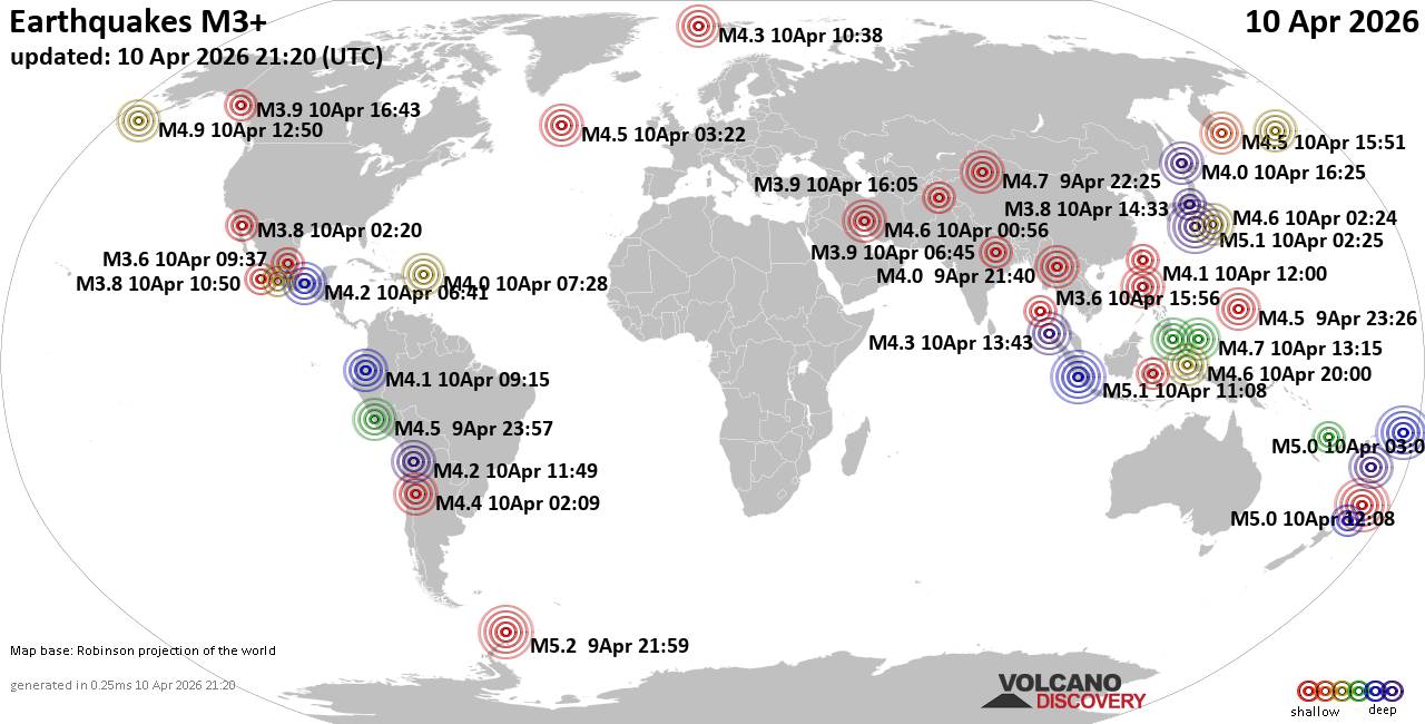 Worldwide earthquakes above magnitude 3 during the past 24 hours on 10 Apr 2026 Magnitude 5+: 5 earthquakes Magnitude 4+: 43 earthquakes Magnitude 3+: 171 earthquakes Magnitude 2+: 382 earthquakes No quakes of magnitude 6 or higher 10 largest earthquakes in the world (past 24 hours)Thursday, Apr 9, 2026, at 05:59 pm (GMT -4) - Friday, Apr 10, 2026, at 11:25 am (GMT +9) - Friday, Apr 10, 2026, at 06:08 pm (Jakarta time) - Friday, Apr 10, 2026, at 04:06 pm (Tongatapu time) - Saturday, Apr 11, 2026, at 12:08 am (GMT +12) - Friday, Apr 10, 2026, at 08:17 pm (GMT +12) - Friday, Apr 10, 2026, at 04:50 am (GMT -8) - Friday, Apr 10, 2026, at 10:15 pm (GMT +9) - Friday, Apr 10, 2026, at 06:25 am (GMT +8) - Saturday, Apr 11, 2026, at 05:00 am (GMT +9) - Earthquakes reported feltThursday, Apr 9, 2026, at 06:57 pm (Lima time) - Friday, Apr 10, 2026, at 12:30 am (GMT +3) - Friday, Apr 10, 2026, at 09:02 am (GMT +2) - Friday, Apr 10, 2026, at 01:43 am (GMT +3) - Friday, Apr 10, 2026, at 08:35 am (Athens time) - Friday, Apr 10, 2026, at 12:30 pm (GMT +2) - Friday, Apr 10, 2026, at 12:56 am (GMT +3) - Friday, Apr 10, 2026, at 06:08 pm (Jakarta time) - Friday, Apr 10, 2026, at 08:00 pm (GMT +8) - Friday, Apr 10, 2026, at 11:25 am (GMT +9) - Friday, Apr 10, 2026, at 07:49 am (La Paz time) - Thursday, Apr 9, 2026, at 11:09 pm (La Rioja time) - Earthquake stats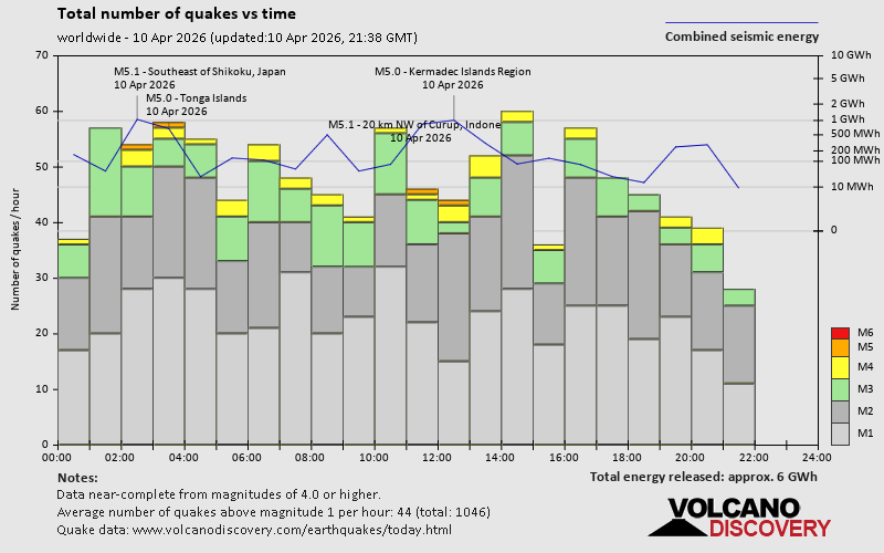 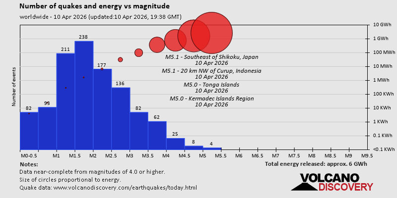  https://www.volcanodiscovery.com/earthquake/news/299645/World-Earthquake-Report-for-Friday-10-April-2026.html https://www.volcanodiscovery.com/earthquake/news/299645/World-Earthquake-Report-for-Friday-10-April-2026.html
0
8
Read More
|
Volcano earthquake report for Friday, 10 Apr 2026
Webmaster
2 hours ago
Volcano earthquake report for Friday, 10 Apr 2026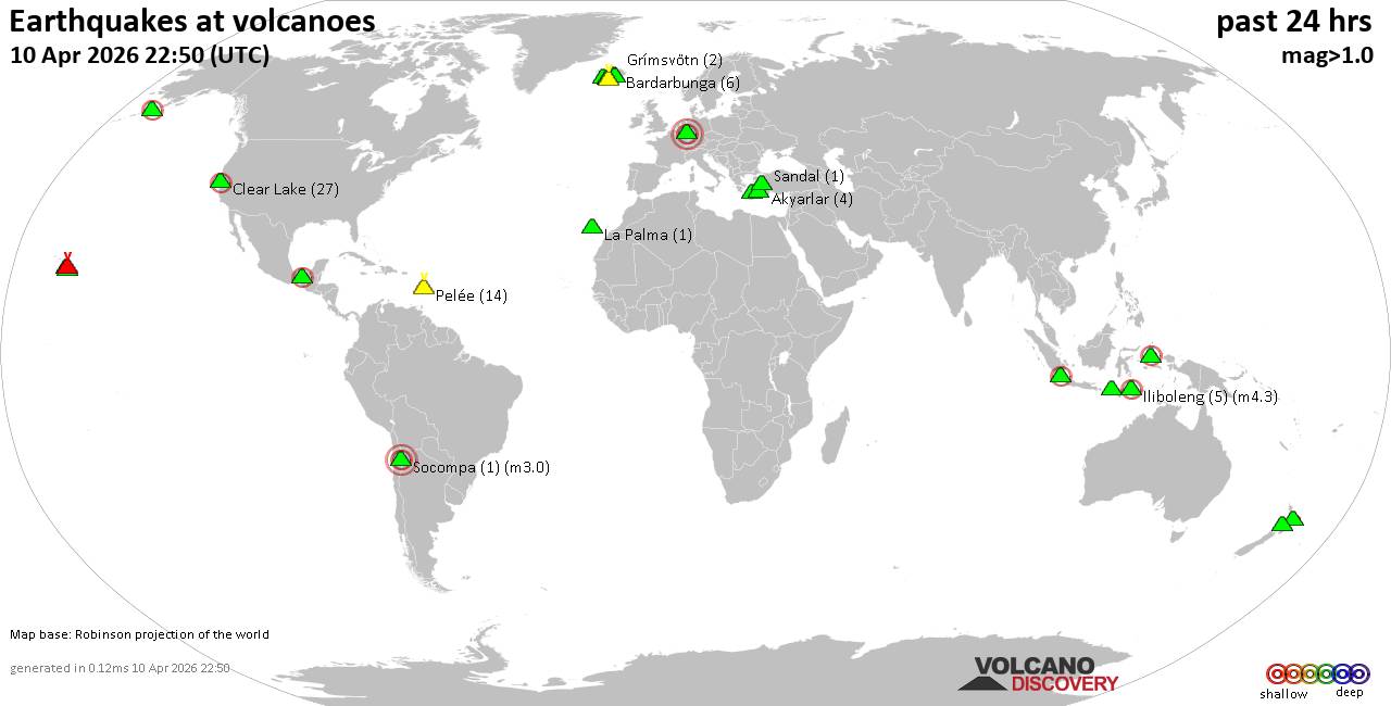 World map showing volcanoes with shallow (less than 50 km) earthquakes within 20 km radius during the past 24 hours on 10 Apr 2026 Number in brackets indicate nr of quakes. Quakes detected near: Akyarlar (3 quakes between mag 1.8-2.2), Bardarbunga (6 quakes between mag 0.1-1.0), Bibinoi (1 quake mag 2.4), Clear Lake (28 quakes between mag 0.2-2.2), El Chichón (5 quakes between mag 1.8-2.3), Grímsvötn (2 quakes between mag 0.3-1.8)
Hrómundartindur (8 quakes between mag 0.0-1.5), Hulubelu (4 quakes between mag 2.1-2.2), Iliboleng (4 quakes between mag 2.1-4.3), Katla (2 quakes between mag 0.8-1.6), Kilauea (19 quakes between mag 1.0-2.6), Kolumbo (1 quake mag 2.4), La Palma (1 quake mag 1.5), Laacher See (1 quake mag 3.0), Loihi (1 quake mag 2.1), Martin (1 quake mag 1.9), Okataina (Tarawera) (1 quake mag 1.6), Ruapehu (1 quake mag 1.1), Sandal (1 quake mag 1.2), Socompa (1 quake mag 3.0), Stepovak Bay 4 (1 quake mag 2.2), Taranaki (1 quake mag 1.2), Tindfjallajökull (1 quake mag 1.1) (updated 20h50)
Note: Earthquakes within 20 km from and at depths less than 50 km under active volcanoes are reported. The list is not complete because many volcanoes are not monitored and/or seismic data in high resolution is not available publicly.
Volcanoes with recent earthquakes above magnitude 2 or more than 10 quakes are listed below:
Akyarlar volcano (Turkey): 3 earthquakes up to magnitude 2.23 earthquakes occurred near (under) the volcano during 11 minutes, the last being recorded quake 7 hours ago. Hypocenter depths ranged between 13.90 and 8.00 km. Earthquake details: 2.2 quake Aegean Sea, 17 km east of Nisi Kos Island, Dodecanese, South Aegean, Greece, Apr 10, 2026 04:15 pm (GMT +3) (17 km S) 1.8 quake Aegean Sea, 11 km east of Nisi Kos Island, Dodecanese, South Aegean, Greece, Apr 10, 2026 04:27 pm (GMT +3) (19 km SSW) 1.8 quake Aegean Sea, 17 km east of Nisi Kos Island, Dodecanese, South Aegean, Greece, Apr 10, 2026 04:16 pm (GMT +3) (16 km S) All earthquakes at AkyarlarBibinoi volcano (Halmahera): magnitude 2.4 earthquakeA magnitude 2.4 earthquake occurred at the volcano 7 hours ago. The quake, which might be volcanic in origin, was located at a depth of 10.00 km depth at 11 km distance NNE from the volcano. Earthquake details: 2.4 quake Maluku Sea, 32 km east of Labuha, Indonesia, Apr 10, 2026 10:48 pm (GMT +9) (11 km NNE) All earthquakes at BibinoiClear Lake volcano (California): 28 earthquakes up to magnitude 2.2Possible earthquake swarm: 28 earthquakes occurred near (under) the volcano during 21 hours, the last being recorded quake 2 hours ago. Hypocenter depths ranged between 5.17 and 0.83 km. Earthquake details: (only 5 largest) 2.2 quake Sonoma County, 14 mi southwest of Clearlake, Lake County, California, United States, Apr 10, 2026 10:30 am (GMT -7) (17 km S) 1.9 quake Sonoma County, 14 mi southwest of Clearlake, Lake County, California, United States, Apr 10, 2026 10:29 am (GMT -7) (17 km S) 1.7 quake Sonoma County, 13 mi southwest of Clearlake, Lake County, California, United States, Apr 9, 2026 04:28 pm (GMT -7) (16 km S) 1.3 quake 27 mi north of Santa Rosa, Sonoma County, California, United States, Apr 10, 2026 12:51 am (GMT -7) (16 km S) 1.2 quake 28 mi north of Santa Rosa, Sonoma County, California, United States, Apr 10, 2026 01:38 am (GMT -7) (16 km SSW) All earthquakes at Clear LakeEl Chichón volcano (Southern Mexico): 5 earthquakes up to magnitude 2.35 earthquakes occurred near (under) the volcano during 9 hours, the last being recorded quake 14 hours ago. Hypocenter depths ranged between 3.00 and 3.00 km. Earthquake details: 2.3 quake Estado de Chiapas, 37 km southwest of Teapa, Estado de Tabasco, Mexico, Apr 9, 2026 04:02 pm (GMT -6) (1 km SE) 2.1 quake Estado de Chiapas, 35 km southwest of Teapa, Estado de Tabasco, Mexico, Apr 10, 2026 12:49 am (GMT -6) (2 km E) 2.1 quake Estado de Chiapas, 37 km southwest of Teapa, Estado de Tabasco, Mexico, Apr 9, 2026 04:03 pm (GMT -6) (1 km NW) 2.0 quake Estado de Chiapas, 36 km southwest of Teapa, Estado de Tabasco, Mexico, Apr 9, 2026 07:49 pm (GMT -6) (1 km NNE) 1.8 quake 20 km southwest of Pichucalco, Estado de Chiapas, Mexico, Apr 9, 2026 04:01 pm (GMT -6) (0 km NNW) All earthquakes at El ChichónHulubelu volcano (Sumatra): 4 earthquakes up to magnitude 2.24 earthquakes occurred near (under) the volcano during 37 minutes, the last being recorded quake 6 hours ago. Hypocenter depths ranged between 8.00 and 4.00 km. Earthquake details: 2.2 quake Kabupaten Tanggamus, 70 km west of Bandar Lampung, Indonesia, Apr 10, 2026 09:27 pm (GMT +7) (12 km SSE) 2.1 quake Kabupaten Tanggamus, 68 km west of Bandar Lampung, Indonesia, Apr 10, 2026 09:27 pm (GMT +7) (12 km SE) 2.1 quake Kabupaten Tanggamus, 68 km west of Bandar Lampung, Indonesia, Apr 10, 2026 10:04 pm (GMT +7) (12 km SE) 2.1 quake Kabupaten Tanggamus, 68 km west of Bandar Lampung, Indonesia, Apr 10, 2026 09:28 pm (GMT +7) (9 km E) All earthquakes at HulubeluIliboleng volcano (Lesser Sunda Islands): 4 earthquakes up to magnitude 4.34 earthquakes occurred near (under) the volcano during 5 hours, the last being recorded quake 15 hours ago. Hypocenter depths ranged between 7.00 and 3.00 km. Earthquake details: 4.3 quake Kabupaten Flores Timur, 31 km west of Lewoleba, Indonesia, Apr 10, 2026 01:39 pm (Makassar time) (16 km SW) 2.8 quake 31 km west of Lewoleba, Kabupaten Lembata, East Nusa Tenggara, Indonesia, Apr 10, 2026 01:41 pm (GMT +8) (16 km SW) 2.2 quake Kabupaten Flores Timur, 32 km west of Lewoleba, Indonesia, Apr 10, 2026 02:04 pm (GMT +8) (17 km SW) 2.1 quake Savu Sea, 14 km southeast of Pulau Adonara Island, East Nusa Tenggara, Indonesia, Apr 10, 2026 09:22 am (GMT +8) (10 km SSW) All earthquakes at IlibolengKilauea volcano (Hawai'i (Big Island)): 19 earthquakes up to magnitude 2.6Possible earthquake swarm: 19 earthquakes occurred near (under) the volcano during 16 hours, the last being recorded quake 3 hours ago. Hypocenter depths ranged between 31.24 and 0.04 km. Earthquake details: (only 5 largest) 2.6 quake 34 mi southwest of Hilo, Hawaii County, Hawaii, United States, Apr 9, 2026 04:25 pm (GMT -10) (13 km SSW) 2.0 quake 26 mi southwest of Hilo, Hawaii County, Hawaii, United States, Apr 9, 2026 04:37 pm (GMT -10) (2 km SE) 1.9 quake 4.5 mi southwest of Volcano, Hawaii County, Hawaii, United States, Apr 9, 2026 05:19 pm (GMT -10) (2 km SSE) 1.9 quake 26 mi southwest of Hilo, Hawaii County, Hawaii, United States, Apr 9, 2026 05:03 pm (GMT -10) (1 km SE) 1.9 quake 26 mi southwest of Hilo, Hawaii County, Hawaii, United States, Apr 9, 2026 07:37 pm (GMT -10) (2 km ESE) All earthquakes at KilaueaKolumbo volcano (Greece): magnitude 2.4 earthquakeA magnitude 2.4 earthquake occurred at the volcano 17 hours ago. The quake, which might be volcanic in origin, was located at a depth of 15.00 km depth at 12 km distance ENE from the volcano. Earthquake details: 2.4 quake Aegean Sea, 21 km northeast of Santorini Island, Greece, Apr 10, 2026 07:01 am (GMT +3) (12 km ENE) All earthquakes at KolumboLaacher See volcano (Germany): magnitude 3.0 earthquakeA magnitude 3.0 earthquake occurred at the volcano 10 hours ago. The quake, which might be volcanic in origin, was located at a depth of 10.00 km depth at 18 km distance SE from the volcano. Earthquake details: Reported seismic-like event (likely no quake): 8.8 km southwest of Koblenz, Germany, Apr 10, 2026 01:13 pm (GMT +2) (18 km SE) All earthquakes at Laacher SeeLoihi volcano (Hawai'i (Big Island)): magnitude 2.1 earthquakeA magnitude 2.1 earthquake occurred at the volcano 6 hours ago. The quake, which might be volcanic in origin, was located at a depth of 12.42 km depth at 14 km distance SE from the volcano. Earthquake details: 2.1 quake North Pacific Ocean, 63 mi south of Hilo, Hawaii County, Hawaii, United States, Apr 10, 2026 05:02 am (GMT -10) (14 km SE) All earthquakes at LoihiSocompa volcano (Northern Chile, Bolivia and Argentina): magnitude 3.0 earthquakeA magnitude 3.0 earthquake occurred at the volcano 4 hours ago. The quake, which might be volcanic in origin, was located at a depth of 10.00 km depth at 11 km distance WSW from the volcano. Earthquake details: Unconfirmed earthquake or seismic-like event: 192 km southeast of Baquedano, Provincia de Antofagasta, Region de Antofagasta, Chile, Apr 10, 2026 02:11 pm (GMT -3) (11 km WSW) All earthquakes at SocompaStepovak Bay 4 volcano (Alaska Peninsula): magnitude 2.2 earthquakeA magnitude 2.2 earthquake occurred at the volcano 4 hours ago. The quake, which might be volcanic in origin, was located at a depth of 6.60 km depth at 7 km distance E from the volcano. Earthquake details: 2.2 quake Lake and Peninsula Borough, 50 mi northeast of Sand Point, Aleutians East Borough, Alaska, United States, Apr 10, 2026 08:48 am (GMT -8) (7 km E) All earthquakes at Stepovak Bay 4https://www.volcanodiscovery.com/earthquakes-volcanoes/news/299640/Volcano-earthquake-report-for-Friday-10-Apr-2026.html
0
8
Read More
|
Moderate magnitude 4.5 earthquake 48 km south of Manokwari, Indonesia
Webmaster
2 hours ago
Moderate magnitude 4.5 earthquake 48 km south of Manokwari, Indonesia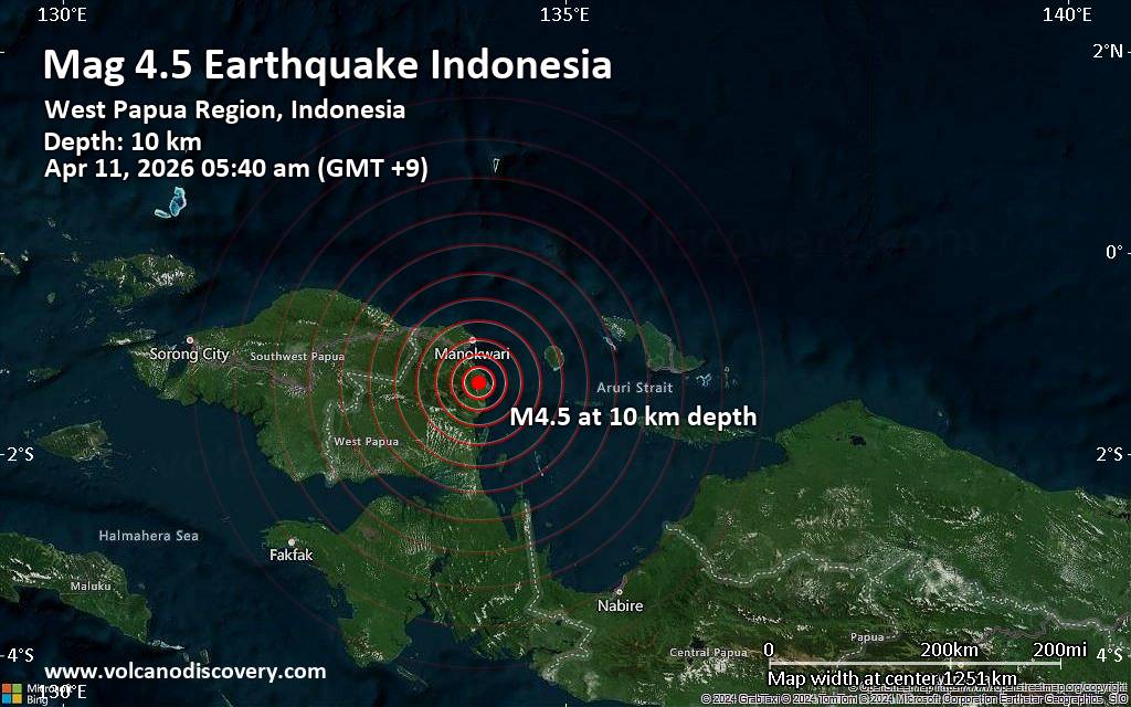 An earthquake of magnitude 4.5 occurred only 7 minutes ago 48 km south of Manokwari, Indonesia, Indonesia's Meteorology, Climatology, and Geophysical Agency reported.
The quake hit at a shallow depth of 10. km beneath the epicenter near Manokwari, Manokwari Regency, Provinsi Papua Barat, Indonesia, early morning on Saturday, April 11th, 2026, at 5:40 am local time. The exact magnitude, epicenter, and depth of the quake might be revised within the next few hours or minutes as seismologists review data and refine their calculations, or as other agencies issue their report.
A second report was later issued by the citizen-seismograph network of RaspberryShake, which listed it as a magnitude 4.5 earthquake as well.
Based on the preliminary seismic data, the quake should not have caused any significant damage, but was probably felt by many people as light vibration in the area of the epicenter.
Weak shaking might have been felt in Ransiki (pop. 16,200) located 24 km from the epicenter, and Manokwari (pop. 107,300) 48 km away.
VolcanoDiscovery will automatically update magnitude and depth if these change and follow up if other significant news about the quake become available. If you’re in the area, please send us your experience through our reporting mechanism, either online or via our mobile app. This will help us provide more first-hand updates to anyone around the globe who wants to know more about this quake.
Earthquake data: Date & time: Apr 11, 2026 05:40 am (GMT +9) local time (10 Apr 2026 20:40 GMT)Magnitude: 4.5 Depth: 10.00 km Epicenter latitude / longitude: 1.29°S / 134.14°E  ( Kabupaten Pegunungan Arfak, Southwest Papua, Indonesia) Primary data source: BMKGhttps://www.volcanodiscovery.com/earthquake/news/299703/Moderate-magnitude-45-earthquake-48-km-south-of-Manokwari-Indonesia.html
0
85
Read More
|
Moderate magnitude 4.7 earthquake 87 km west of Waisai, Indonesia
Webmaster
3 hours ago
Moderate magnitude 4.7 earthquake 87 km west of Waisai, Indonesia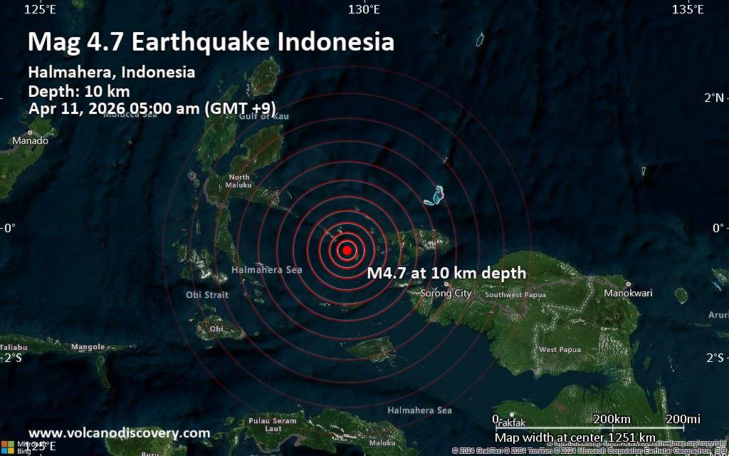 Just 9 minutes ago, a 4.7-magnitude earthquake struck near Waisai, Raja Ampat Regency, Southwest Papua, Indonesia. The tremor was recorded early morning on Saturday, April 11th, 2026, at 5:00 am local time, at a shallow depth of 10. km below the surface.
The event was filed by Indonesia's Meteorology, Climatology, and Geophysical Agency, the first seismological agency to report it.
Our monitoring service identified a second report from the citizen-seismograph network of RaspberryShake which listed the quake at magnitude 4.7 as well.
Towns or cities near the epicenter where the quake might have been felt as very weak shaking include Waisai (pop. 22,500) located 87 km from the epicenter.
VolcanoDiscovery will automatically update magnitude and depth if these change and follow up if other significant news about the quake become available. If you’re in the area, please send us your experience through our reporting mechanism, either online or via our mobile app. This will help us provide more first-hand updates to anyone around the globe who wants to know more about this quake.
Earthquake data: Date & time: Apr 11, 2026 05:00 am (GMT +9) local time (10 Apr 2026 20:00 GMT)Magnitude: 4.7 Depth: 10.00 km Epicenter latitude / longitude: 0.35°S / 129.73°E (Raja Ampat Regency, Provinsi Papua Barat, Indonesia) Primary data source: BMKGhttps://www.volcanodiscovery.com/earthquake/news/299699/Moderate-magnitude-47-earthquake-87-km-west-of-Waisai-Indonesia.html
0
Read More
|
Sunday: Light Rain, Minimum Temperature: 3°C (37°F) Maximum Temperature: 13°C (56°F)
Webmaster
3 hours ago
Maximum Temperature: 13°C (56°F), Minimum Temperature: 3°C (37°F), Wind Direction: south-westerly, Wind Speed: 11mph, Visibility: Very Good, Pressure: 1006mb, Humidity: 62%, UV Risk: 4, Pollution: Low, Sunrise: 06:17 BST, Sunset: 20:04 BST Source: Sunday: Light Rain, Minimum Temperature: 3°C (37°F) Maximum Temperature: 13°C (56°F)
0
2
Read More
|
Saturday: Heavy Rain, Minimum Temperature: 7°C (45°F) Maximum Temperature: 11°C (52°F)
Webmaster
3 hours ago
Maximum Temperature: 11°C (52°F), Minimum Temperature: 7°C (45°F), Wind Direction: south-westerly, Wind Speed: 15mph, Visibility: Moderate, Pressure: 1001mb, Humidity: 65%, UV Risk: 3, Pollution: Low, Sunrise: 06:19 BST, Sunset: 20:02 BST Source: Saturday: Heavy Rain, Minimum Temperature: 7°C (45°F) Maximum Temperature: 11°C (52°F)
0
2
Read More
|
SPC Apr 10, 2026 2000 UTC Day 1 Convective Outlook
Webmaster
3 hours ago
SPC Apr 10, 2026 2000 UTC Day 1 Convective OutlookSPC 2000Z Day 1 Outlook 
Day 1 Convective Outlook
NWS Storm Prediction Center Norman OK
0252 PM CDT Fri Apr 10 2026

Valid 102000Z - 111200Z

...THERE IS A MARGINAL RISK OF SEVERE THUNDERSTORMS OVER PARTS OF
OREGON...THE CENTRAL VALLEY OF CALIFORNIA...THE GREAT BASIN AND
SOUTHERN PLAINS/OZARKS...

...SUMMARY...
Thunderstorms with isolated large hail and severe gusts remain
possible this afternoon and evening across parts of the
south-central Plains to the Ozarks. Strong to locally severe storms
may also occur from western/northern Nevada into southeast Oregon
and southwest Idaho, and also across parts of north-central
California.

...20z Update...
Minimal changes were made to the prior outlook. A prominent
differential heating/outflow boundary associated with a cluster of
thunderstorms over OK is forecast to continue sagging southward this
afternoon. An increase in storm coverage is possible this afternoon
and evening associated with the ongoing cluster and the trailing
boundary. With moderate buoyancy weak vertical shear, a low-end risk
for damaging gusts and hail could develop. 5% wind and hail
probabilities have been expanded slightly farther southeastward.

To the West across the Great Basin, strong mid-level ascent ahead of
the upper low over the Pacific Coast was overspreading a marginally
moist and buoyant air mass across parts of NV. Strong southerly flow
aloft could support a few semi-organized storms or clusters capable
of damaging gusts and sporadic hail. 5% wind and hail probabilities
have been expanded southward over parts of NV where buoyancy and
shear overlap could support some severe potential.

Otherwise, isolated severe storms remain possible across parts of
the central Valley of CA and western OR. The forecast remains
unchanged, see the prior discussion for more information.

..Lyons.. 04/10/2026

.PREV DISCUSSION... /ISSUED 1130 AM CDT Fri Apr 10 2026/

...Southern High Plains/South-central Plains into the Ozarks...
Recent surface analysis places a low over the western TX Panhandle,
with a cold front extending east-northeastward from this low across
northwest and north-central OK, and far southeast KS, before
becoming oriented more northeastward across southern and central MO.
Showers and thunderstorms are ongoing in the vicinity of this
boundary, as well modest southeastward-progressing outflow, across
far southern KS and northern OK.

The cold front is forecast to trend more stationary throughout the
day as heights rise across the Plains and southerly low-level flow
persists across the southern Plains, with the outflow following this
trend as well. After 06Z, this stationary boundary will likely begin
shifting back northward into southern KS as warm front. Additional
thunderstorm development is possible amid low-level convergence near
both the stationary front and outflow as the airmass modestly
destabilizes this afternoon. Isolated damaging gusts and/or
marginally severe hail is possible with the strongest storms, but
modest shear and buoyancy suggests most storms will be sub-severe.

Farther west, low-level convergence along a sharpening lee trough
may contribute to late afternoon thunderstorm development across the
southern High Plain, particularly northeast NM. High cloud bases and
steep low-level lapse rates support the potential for strong
downbursts with any deep/more persistent updrafts. Some interaction
with the western extent of the frontal zone is possible as well,
which could briefly enhance updrafts, contributing to a continued
potential for damaging gusts as well as isolated hail.

...North-central CA/western OR into the northern Great Basin...
Upper low currently centered just off the northern/central CA coast
is forecast to become more progressive and negatively tilted
throughout the day today. Mid-level moisture and ascent attendant to
this wave will support scattered thunderstorm development this
afternoon from central/northern CA and western OR into the northern
Great Basin and interior Northwest. Cold temperatures aloft (i.e.
-20 deg C at 500 mb) and strong diurnal heating will result in steep
low/mid-level lapse rates and at least modest buoyancy across much
of the region.

A few areas (interior valley of central CA, Willamette Valley in OR,
and northern NV/southwest OR/southern ID) appear to have a slightly
higher potential for isolated strong to severe storms, largely a
result of more diurnal heating/higher afternoon temperatures.
Greater buoyancy combined with moderate/strong deep-layer shear will
support semi-organized cells/clusters, and perhaps even a few
supercells, may develop with an attendant threat of hail and
localized severe wind gusts. Deep-layer shear will be a bit weaker
across the interior valley of central CA but still sufficient for a
few organized storms. The steep lapse rate environment and local
terrain influences could also support transient cell rotation and
possibly funnels, or even a brief tornado.
Read morehttps://www.spc.noaa.gov/products/outlook/day1otlk_2000.html
0
Read More
|
|
Forums60
Topics768,629
Posts803,394
Members2,958
| |
Most Online17,963
Jan 15th, 2026
|
|
|
|
|
Copyright 1996 - 2026 by David Cottle. Designed by David Bate Jr. All Rights Reserved.
By using this forum, the user agrees not to transfer any data or technical information received under the agreement, to any other entity without the express approval of the AUS-CITY Forum Admins and/or authors of individual posts (Forum Admins and DoD/USSPACECOM for the analysis of satellite tracking data).
Two-line elements (TLE) and all other satellite data presented and distributed via this forum and e-mail lists of AUS-CITY are distributed with permission from DoD/USSTRATCOM.


Reprise Hosting

|

|


 - Click image for larger picture.")


