|
|
|
0 members (),
2,441
guests, and
28
robots. |
|
Key:
Admin,
Global Mod,
Mod
|
|
S |
M |
T |
W |
T |
F |
S |
|
|
|
|
1
|
2
|
3
|
4
|
|
5
|
6
|
7
|
8
|
9
|
10
|
11
|
|
12
|
13
|
14
|
15
|
16
|
17
|
18
|
|
19
|
20
|
21
|
22
|
23
|
24
|
25
|
|
26
|
27
|
28
|
29
|
30
|
|
|
|
There are no members with birthdays on this day. |
 Small magnitude 3.0 quake hits 3 miles west of Daly City, California, United States in the afternoon
Webmaster
Yesterday at 11:55 PM
Small magnitude 3.0 quake hits 3 miles west of Daly City, California, United States in the afternoon
Webmaster
Yesterday at 11:55 PM
Small magnitude 3.0 quake hits 3 miles west of Daly City, California, United States in the afternoon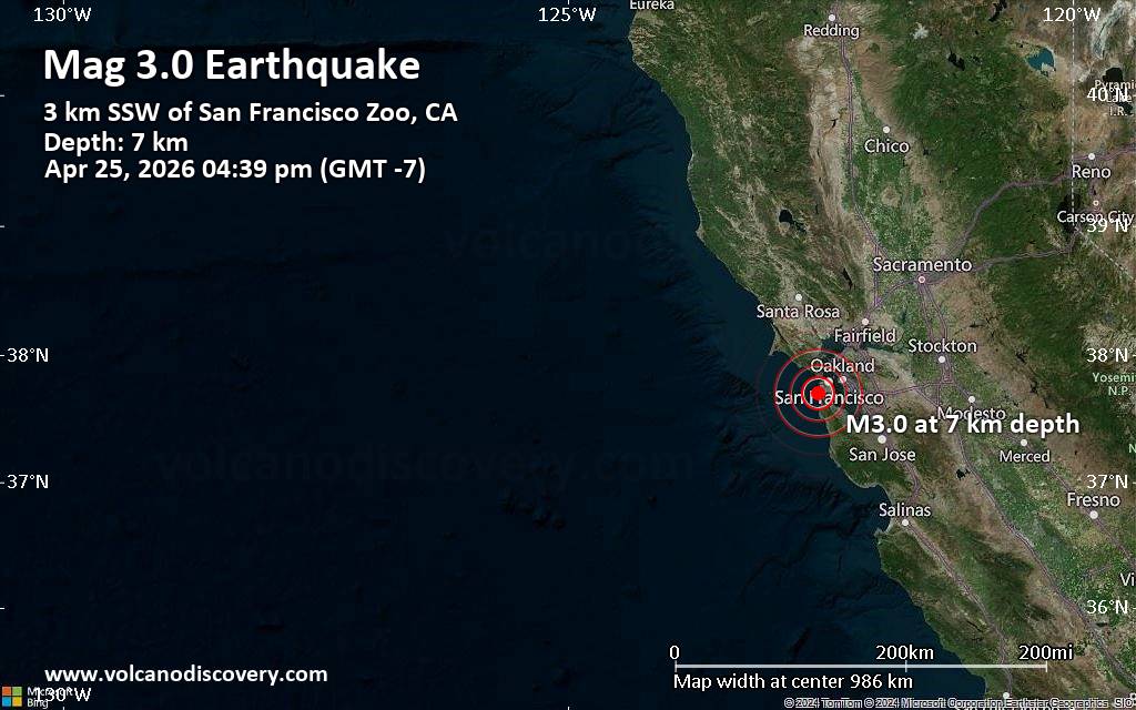 An earthquake of magnitude 3.0 occurred only 14 minutes ago 3 miles west of Daly City, California, United States, the United States Geological Survey reported.
The quake hit at a very shallow depth of 4.3 miles beneath the epicenter near Daly City, San Mateo County, California, USA, in the afternoon on Saturday, April 25th, 2026, at 4:39 pm local time. The exact magnitude, epicenter, and depth of the quake might be revised within the next few hours or minutes as seismologists review data and refine their calculations, or as other agencies issue their report.
A second report was later issued by The Incorporated Research Institutions for Seismology (IRIS), which listed it as a magnitude 3.0 earthquake as well. A third agency, the European-Mediterranean Seismological Centre (EMSC), reported the same quake at magnitude 2.9.
Based on the preliminary seismic data, the quake should not have caused any significant damage, but was probably felt by many people as light vibration in the area of the epicenter.
Weak shaking might have been felt in Broadmoor (pop. 4,200) located 2 miles from the epicenter, and Daly City (pop. 106,600) 3 miles away.
Other towns or cities near the epicenter where the quake might have been felt as very weak shaking include Pacifica (pop. 39,300) located 6 miles from the epicenter, South San Francisco (pop. 67,300) 7 miles away, San Francisco (pop. 827,500) 7 miles away, San Bruno (pop. 43,200) 8 miles away, San Mateo (pop. 103,500) 14 miles away, and Oakland (pop. 419,300) 15 miles away. In San Jose (pop. 997,400, 42 miles away), the quake was probably not felt.
Earthquake data: Date & time: Apr 25, 2026 04:39 pm (GMT -7) local time (25 Apr 2026 23:39 GMT)Magnitude: 3.0 Depth: 6.96 km Epicenter latitude / longitude: 37.7°N / 122.52°W  (San Francisco County, California, United States) Primary data source: USGShttps://www.volcanodiscovery.com/earthquake/news/300726/Small-magnitude-30-quake-hits-3-miles-west-of-Daly-City-California-United-States-in-the-afternoon-.html
0
12
Read More
|
Volcano earthquake report for Saturday, 25 Apr 2026
Webmaster
Yesterday at 11:50 PM
Volcano earthquake report for Saturday, 25 Apr 2026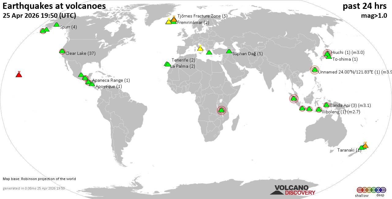 World map showing volcanoes with shallow (less than 50 km) earthquakes within 20 km radius during the past 24 hours on 25 Apr 2026 Number in brackets indicate nr of quakes. Quakes detected near: Akuseki-jima (2 quakes between mag 2.8-3.3), Apaneca Range (1 quake mag 2.2), Apoyeque (1 quake mag 1.5), Baluran (1 quake mag 2.4), Banda Api (3 quakes between mag 2.2-3.1), Bardarbunga (23 quakes between mag 0.0-3.2)
Campi Flegrei (Phlegrean Fields) (9 quakes between mag 0.1-1.8), Cerro Singüil (1 quake mag 2.3), Clear Lake (41 quakes between mag 0.2-2.1), Coso (4 quakes between mag 0.3-1.0), El Chichón (3 quakes between mag 2.2-2.7), Eldey (39 quakes between mag 0.0-1.7), Fremrinámar (2 quakes between mag 0.5-1.3), Hiuchi (1 quake mag 3.0), Iliboleng (3 quakes between mag 2.1-3.0), Ililabalekan (1 quake mag 2.0), Izumbwe-Mpoli (1 quake mag 3.0), Kilauea (6 quakes between mag 1.7-2.1), Kolumbo (1 quake mag 1.3), Kusatsu-Shirane (1 quake mag 2.8), La Palma (1 quake mag 1.5), Lewotolo (1 quake mag 2.5), Los Humeros (1 quake mag 3.8), Maunaloa (1 quake mag 1.9), Mayotte Island (1 quake mag 1.0), Paluweh (1 quake mag 2.2), Papandayan (1 quake mag 2.2), Sorikmarapi (1 quake mag 3.0), Sousaki (1 quake mag 1.3), Spurr (4 quakes between mag 0.4-1.2), Stepovak Bay 4 (1 quake mag 2.1), Svartsengi (2 quakes between mag 1.5-1.8), Süphan Dağ (4 quakes between mag 1.8-2.4), Taranaki (1 quake mag 1.5), Taupo (1 quake mag 1.3), Theistareykjarbunga (6 quakes between mag 0.1-1.4), Tjörnes Fracture Zone (5 quakes between mag 0.5-1.3), To-shima (1 quake mag 2.5), Torfajökull (3 quakes between mag 0.3-2.6), Toroeng Prong (1 quake mag 2.7), Whale Island (2 quakes between mag 1.9-2.5), Öraefajökull (1 quake mag 1.4) (updated 23h50)
Note: Earthquakes within 20 km from and at depths less than 50 km under active volcanoes are reported. The list is not complete because many volcanoes are not monitored and/or seismic data in high resolution is not available publicly.
Volcanoes with recent earthquakes above magnitude 2 or more than 10 quakes are listed below:
Akuseki-jima volcano (Ryukyu Islands): 2 earthquakes up to magnitude 3.32 earthquakes occurred near (under) the volcano during 33 minutes, the last being recorded quake 1 hour 3 minutes ago. Hypocenter depths ranged between 20.00 and 6.80 km. Earthquake details: 3.3 quake East China Sea, Kagoshima-ken, 33 km southwest of Suwanose-jima Island, Japan, Apr 26, 2026 07:14 am (GMT +9) (12 km SW) 2.8 quake East China Sea, Kagoshima-ken, 32 km southwest of Suwanose-jima Island, Japan, Apr 26, 2026 07:47 am (GMT +9) (10 km SW) All earthquakes at Akuseki-jimaApaneca Range volcano (El Salvador): magnitude 2.2 earthquakeA magnitude 2.2 earthquake occurred at the volcano 8 hours ago. The quake, which might be volcanic in origin, was located at a depth of 6.00 km depth at 3 km distance SSW from the volcano. Earthquake details: 2.2 quake 8.1 km southeast of Ahuachapan, Departamento de Ahuachapan, El Salvador, Apr 25, 2026 09:59 am (GMT -6) (3 km SSW) All earthquakes at Apaneca RangeBaluran volcano (East Java): magnitude 2.4 earthquakeA magnitude 2.4 earthquake occurred at the volcano 20 hours ago. The quake, which might be volcanic in origin, was located at a depth of 14.00 km depth at 2 km distance W from the volcano. Earthquake details: 2.4 quake Kabupaten Situbondo, 17 km north of Wongsorejo, Indonesia, Apr 25, 2026 11:05 am (GMT +7) (2 km W) All earthquakes at BaluranBanda Api volcano (Banda Sea): 3 earthquakes up to magnitude 3.13 earthquakes occurred near (under) the volcano during 1 hour 49 minutes, the last being recorded quake 18 hours ago. Hypocenter depths ranged between 6.00 and 5.00 km. Earthquake details: 3.1 quake Banda Sea, 17 km north of Pulau Banda Besar Island, Maluku, Indonesia, Apr 25, 2026 12:42 pm (GMT +9) (15 km NNE) 3.0 quake Banda Sea, 12 km northwest of Pulau Banda Besar Island, Maluku, Indonesia, Apr 25, 2026 12:48 pm (GMT +9) (7 km N) 2.2 quake Banda Sea, 16 km west of Pulau Banda Besar Island, Maluku, Indonesia, Apr 25, 2026 02:31 pm (GMT +9) (11 km W) All earthquakes at Banda ApiBardarbunga volcano (Iceland): 23 earthquakes up to magnitude 3.2Possible earthquake swarm: 23 earthquakes occurred near (under) the volcano during 20 hours, the last being recorded quake 3 hours ago. Hypocenter depths ranged between 21.00 and 0.00 km. Earthquake details: (only 5 largest) 3.2 quake 124 km south of Akureyri, Northeast, Iceland, Apr 25, 2026 02:34 pm (Reykjavik time) (7 km ESE) 1.9 quake 4.0 km SSE of Bárðarbunga Apr 25, 2026 02:35 pm (Universal Time) (3 km SSE) 1.4 quake Iceland: 4.6 km SE of Bárðarbunga Apr 25, 2026 02:54 pm (Reykjavik time) (4 km ESE) 1.1 quake Iceland: 3.9 km SSE of Bárðarbunga Apr 25, 2026 01:35 am (Reykjavik time) (3 km SSE) 0.9 quake Iceland: 2.3 km ESE of Bárðarbunga Apr 25, 2026 02:55 pm (Reykjavik time) (2 km E) All earthquakes at BardarbungaCerro Singüil volcano (El Salvador): magnitude 2.3 earthquakeA magnitude 2.3 earthquake occurred at the volcano 20 hours ago. The quake, which might be volcanic in origin, was located at a depth of 7.00 km depth at 17 km distance W from the volcano. Earthquake details: 2.3 quake 14 km north of Ahuachapan, Departamento de Ahuachapan, El Salvador, Apr 24, 2026 10:09 pm (GMT -6) (17 km W) All earthquakes at Cerro SingüilClear Lake volcano (California): 41 earthquakes up to magnitude 2.1Possible earthquake swarm: 41 earthquakes occurred near (under) the volcano during 23 hours, the last being recorded quake 20 minutes ago. Hypocenter depths ranged between 4.75 and 0.61 km. Earthquake details: (only 5 largest) 2.1 quake Sonoma County, 13 mi southwest of Clearlake, Lake County, California, United States, Apr 24, 2026 06:14 pm (GMT -7) (16 km S) 1.5 quake 7 km W of Cobb, CA, Apr 25, 2026 04:29 pm (GMT -7) (16 km S) 1.3 quake 28 mi north of Santa Rosa, Sonoma County, California, United States, Apr 25, 2026 02:39 pm (GMT -7) (16 km SSW) 1.3 quake 28 mi north of Santa Rosa, Sonoma County, California, United States, Apr 24, 2026 06:18 pm (GMT -7) (15 km S) 1.3 quake 27 mi north of Santa Rosa, Sonoma County, California, United States, Apr 24, 2026 05:31 pm (GMT -7) (18 km SSW) All earthquakes at Clear LakeEl Chichón volcano (Southern Mexico): 3 earthquakes up to magnitude 2.73 earthquakes occurred near (under) the volcano during 9 hours, the last being recorded quake 15 hours ago. Hypocenter depths ranged between 3.00 and 2.40 km. Earthquake details: 2.7 quake Estado de Chiapas, 37 km southwest of Teapa, Estado de Tabasco, Mexico, Apr 25, 2026 02:56 am (GMT -6) (1 km NNW) 2.3 quake Estado de Chiapas, 35 km southwest of Teapa, Estado de Tabasco, Mexico, Apr 24, 2026 05:56 pm (GMT -6) (2 km N) 2.2 quake Estado de Chiapas, 35 km southwest of Teapa, Estado de Tabasco, Mexico, Apr 24, 2026 06:28 pm (GMT -6) (2 km NNE) All earthquakes at El ChichónEldey volcano (Iceland): 39 earthquakes up to magnitude 1.7Possible earthquake swarm: 39 earthquakes occurred near (under) the volcano during 5 hours, the last being recorded quake 19 minutes ago. Hypocenter depths ranged between 9.20 and 0.00 km. Earthquake details: (only 5 largest) 1.7 quake Iceland: 4.4 km NW of Reykjanestá Apr 25, 2026 11:15 pm (Reykjavik time) (15 km NE) 1.7 quake Iceland: 4.9 km WNW of Reykjanestá Apr 25, 2026 11:03 pm (Reykjavik time) (14 km NE) 1.7 quake Iceland: 5.3 km WNW of Reykjanestá Apr 25, 2026 10:53 pm (Reykjavik time) (13 km NE) 1.6 quake Iceland: 4.7 km W of Reykjanestá Apr 25, 2026 11:13 pm (Reykjavik time) (13 km NE) 1.4 quake 4.7 km NW of Reykjanestá Apr 25, 2026 11:29 pm (Universal Time) (15 km NE) All earthquakes at EldeyEldey is located at the beginning of the Reykjanes Ridge off the SW tip of Iceland. Its highest elevation is the top of Eldey Island, but most of the volcanic edifice is submerged. Several eruptions occurred in historic times, last in 1926. Hiuchi volcano (Honshu): magnitude 3.0 earthquakeA magnitude 3.0 earthquake occurred at the volcano 19 hours ago. The quake, which might be volcanic in origin, was located at a depth of 10.00 km depth at 15 km distance NNW from the volcano. Earthquake details: Reported seismic-like event (likely no quake): 31 km southeast of Uonuma, Niigata, Japan, Apr 25, 2026 01:27 pm (GMT +9) (15 km NNW) All earthquakes at HiuchiIliboleng volcano (Lesser Sunda Islands): 3 earthquakes up to magnitude 3.03 earthquakes occurred near (under) the volcano during 10 hours, the last being recorded quake 1 hour 33 minutes ago. Hypocenter depths ranged between 4.00 and 3.00 km. Earthquake details: 3.0 quake Kabupaten Flores Timur, 28 km southwest of Lewoleba, Indonesia, Apr 26, 2026 06:17 am (GMT +8) (17 km SSW) 2.7 quake Kabupaten Flores Timur, 28 km west of Lewoleba, Indonesia, Apr 25, 2026 08:27 pm (GMT +8) (15 km SW) 2.1 quake Savu Sea, 17 km south of Pulau Adonara Island, East Nusa Tenggara, Indonesia, Apr 26, 2026 04:32 am (GMT +8) (18 km SW) All earthquakes at IlibolengIzumbwe-Mpoli volcano (Tanzania): magnitude 3.0 earthquakeA magnitude 3.0 earthquake occurred at the volcano 18 hours ago. The quake, which might be volcanic in origin, was located at a depth of 10.00 km depth at 2 km distance E from the volcano. Earthquake details: Reported seismic-like event (likely no quake): 5.2 km southwest of Mbeya, Mbeya Region, Tanzania, Apr 25, 2026 08:56 am (GMT +3) (2 km E) All earthquakes at Izumbwe-MpoliKilauea volcano (Hawai'i (Big Island)): 6 earthquakes up to magnitude 2.16 earthquakes occurred near (under) the volcano during 13 hours, the last being recorded quake 1 hour 9 minutes ago. Hypocenter depths ranged between 0.69 and 0.38 km. Earthquake details: (only 5 largest) 2.1 quake 26 mi southwest of Hilo, Hawaii County, Hawaii, United States, Apr 24, 2026 11:59 pm (GMT -10) (1 km SE) 2.0 quake 26 mi southwest of Hilo, Hawaii County, Hawaii, United States, Apr 25, 2026 09:58 am (GMT -10) (1 km SE) 1.8 quake 4.3 mi southwest of Volcano, Hawaii County, Hawaii, United States, Apr 25, 2026 12:41 pm (GMT -10) (0 km SSE) 1.8 quake 3.7 mi southwest of Volcano, Hawaii County, Hawaii, United States, Apr 25, 2026 05:50 am (GMT -10) (3 km ESE) 1.8 quake 4 mi southwest of Volcano, Hawaii County, Hawaii, United States, Apr 25, 2026 05:50 am (GMT -10) (1 km E) All earthquakes at KilaueaKusatsu-Shirane volcano (Honshu): magnitude 2.8 earthquakeA magnitude 2.8 earthquake occurred at the volcano 11 hours ago. The quake, which might be volcanic in origin, was located at a depth of 5.60 km depth at 18 km distance W from the volcano. Earthquake details: 2.8 quake 14 km east of Nagano, Nagano, Japan, Apr 25, 2026 09:41 pm (GMT +9) (18 km W) All earthquakes at Kusatsu-ShiraneLewotolo volcano (Lesser Sunda Islands): magnitude 2.5 earthquakeA magnitude 2.5 earthquake occurred at the volcano 1 hour 25 minutes ago. The quake, which might be volcanic in origin, was located at a depth of 6.00 km depth at 3 km distance NNW from the volcano. Earthquake details: 2.5 quake 16 km northeast of Lewoleba, Kabupaten Lembata, East Nusa Tenggara, Indonesia, Apr 26, 2026 06:24 am (GMT +8) (3 km NNW) All earthquakes at LewotoloLos Humeros volcano (Western & Central Mexico): magnitude 3.8 earthquakeA magnitude 3.8 earthquake occurred at the volcano 15 hours ago. The quake, which might be volcanic in origin, was located at a depth of 27.60 km depth at 19 km distance NNE from the volcano. Earthquake details: 3.8 quake 1.4 km north of Teziutlan, Estado de Puebla, Mexico, Apr 25, 2026 02:23 am (Mexico City time) (19 km NNE) All earthquakes at Los HumerosPaluweh volcano (Lesser Sunda Islands): magnitude 2.2 earthquakeA magnitude 2.2 earthquake occurred at the volcano 1 hour 2 minutes ago. The quake, which might be volcanic in origin, was located at a depth of 6.00 km depth at 14 km distance S from the volcano. Earthquake details: 2.2 quake Flores Sea, 45 km north of Ende, Kabupaten Ende, East Nusa Tenggara, Indonesia, Apr 26, 2026 06:48 am (GMT +8) (14 km S) All earthquakes at PaluwehPapandayan volcano (West Java): magnitude 2.2 earthquakeA magnitude 2.2 earthquake occurred at the volcano 15 hours ago. The quake, which might be volcanic in origin, was located at a depth of 5.00 km depth at 12 km distance NNW from the volcano. Earthquake details: 2.2 quake 29 km east of Banjar, Kabupaten Bandung, Jawa Barat, Indonesia, Apr 25, 2026 03:40 pm (GMT +7) (12 km NNW) All earthquakes at PapandayanSorikmarapi volcano (Sumatra): magnitude 3.0 earthquakeA magnitude 3.0 earthquake occurred at the volcano 17 hours ago. The quake, which might be volcanic in origin, was located at a depth of 5.00 km depth at 16 km distance SSE from the volcano. Earthquake details: 3.0 quake Kabupaten Mandailing Natal, 100 km south of Padangsidempuan, Indonesia, Apr 25, 2026 01:25 pm (GMT +7) (16 km SSE) All earthquakes at SorikmarapiStepovak Bay 4 volcano (Alaska Peninsula): magnitude 2.1 earthquakeA magnitude 2.1 earthquake occurred at the volcano 5 hours ago. The quake, which might be volcanic in origin, was located at a depth of 8.20 km depth at 5 km distance SSE from the volcano. Earthquake details: 2.1 quake 46 mi northeast of Sand Point, Aleutians East Borough, Alaska, United States, Apr 25, 2026 11:18 am (GMT -8) (5 km SSE) All earthquakes at Stepovak Bay 4Süphan Dağ volcano (Turkey): 4 earthquakes up to magnitude 2.44 earthquakes occurred near (under) the volcano during 10 hours, the last being recorded quake 10 hours ago. Hypocenter depths ranged between 7.00 and 2.90 km. Earthquake details: 2.4 quake Bitlis, 20 km south of Patnos, Agri, Turkey, Apr 25, 2026 12:16 pm (GMT +3) (13 km N) 2.2 quake 20 km northeast of Adilcevaz, Bitlis, Turkey, Apr 25, 2026 07:13 am (GMT +3) (3 km NNE) 2.1 quake Bitlis, 23 km south of Patnos, Agri, Turkey, Apr 25, 2026 11:17 am (GMT +3) (10 km N) 1.8 quake Bitlis, 23 km south of Patnos, Agri, Turkey, Apr 25, 2026 05:11 pm (GMT +3) (10 km N) All earthquakes at Süphan DağTo-shima volcano (Izu Islands): magnitude 2.5 earthquakeA magnitude 2.5 earthquake occurred at the volcano 12 hours ago. The quake, which might be volcanic in origin, was located at a depth of 13.40 km depth at 12 km distance E from the volcano. Earthquake details: 2.5 quake North Pacific Ocean, Tokyo, 45 km east of Shimoda, Shizuoka, Japan, Apr 25, 2026 08:30 pm (GMT +9) (12 km E) All earthquakes at To-shimaTorfajökull volcano (Iceland): 3 earthquakes up to magnitude 2.63 earthquakes occurred near (under) the volcano during 9 hours, the last being recorded quake 9 hours ago. Hypocenter depths ranged between 4.50 and 0.00 km. Earthquake details: 2.6 quake Iceland: 1.0 km N of Álftavatn Apr 25, 2026 02:35 pm (Reykjavik time) (8 km SSW) 0.4 quake Iceland: 7.0 km WSW of Landmannalaugar Apr 25, 2026 05:41 am (Reykjavik time) (4 km N) 0.3 quake Iceland: 4.7 km WSW of Landmannalaugar Apr 25, 2026 05:41 am (Reykjavik time) (4 km NNE) All earthquakes at TorfajökullToroeng Prong volcano (Vietnam): magnitude 2.7 earthquakeA magnitude 2.7 earthquake occurred at the volcano 2 hours ago. The quake, which might be volcanic in origin, was located at a depth of 10.00 km depth at 15 km distance WNW from the volcano. Earthquake details: 2.7 quake 60 km north of Kon Tum, Kon Tum, Vietnam, Apr 26, 2026 04:45 am (GMT +7) (15 km WNW) All earthquakes at Toroeng ProngWhale Island volcano (New Zealand): 2 earthquakes up to magnitude 2.52 earthquakes occurred near (under) the volcano during 1 hour 34 minutes, the last being recorded quake 20 hours ago. Hypocenter depths ranged between 5.00 and 5.00 km. Earthquake details: 2.5 quake South Pacific Ocean, 8.7 km northwest of Whakatane, Bay of Plenty, New Zealand, Apr 25, 2026 02:27 pm (GMT +12) (6 km SW) 1.9 quake South Pacific Ocean, 11 km northwest of Whakatane, Bay of Plenty, New Zealand, Apr 25, 2026 04:01 pm (GMT +12) (4 km W) All earthquakes at Whale Islandhttps://www.volcanodiscovery.com/earthquakes-volcanoes/news/300651/Volcano-earthquake-report-for-Saturday-25-Apr-2026.html
0
7
Read More
|
World Earthquake Report for Saturday, 25 April 2026
Webmaster
Yesterday at 11:20 PM
World Earthquake Report for Saturday, 25 April 2026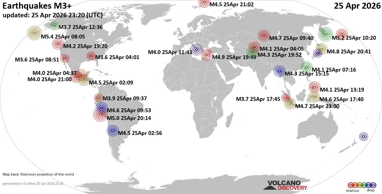 Worldwide earthquakes above magnitude 3 during the past 24 hours on 25 Apr 2026 Magnitude 5+: 3 earthquakes Magnitude 4+: 41 earthquakes Magnitude 3+: 168 earthquakes Magnitude 2+: 399 earthquakes No quakes of magnitude 6 or higher 10 largest earthquakes in the world (past 24 hours)Saturday, Apr 25, 2026, at 12:05 am (GMT -8) - Saturday, Apr 25, 2026, at 10:20 pm (Kamchatka time) - Saturday, Apr 25, 2026, at 03:14 pm (GMT -5) - Saturday, Apr 25, 2026, at 10:49 pm (Athens time) - Sunday, Apr 26, 2026, at 05:41 am (GMT +9) - Sunday, Apr 26, 2026, at 06:00 am (GMT +7) - Saturday, Apr 25, 2026, at 04:40 pm (Krasnoyarsk time) - Sunday, Apr 26, 2026, at 01:46 am (Kamchatka time) - Sunday, Apr 26, 2026, at 02:40 am (GMT +9) - Saturday, Apr 25, 2026, at 06:07 pm (GMT +9) - Earthquakes reported feltSaturday, Apr 25, 2026, at 03:10 am (GMT +2) - Saturday, Apr 25, 2026, at 10:49 pm (Athens time) - Saturday, Apr 25, 2026, at 03:12 am (Madrid time) - Saturday, Apr 25, 2026, at 03:01 am (GMT +2) - Saturday, Apr 25, 2026, at 10:20 pm (Kamchatka time) - Saturday, Apr 25, 2026, at 09:52 pm (Athens time) - Saturday, Apr 25, 2026, at 04:47 am (Athens time) - Saturday, Apr 25, 2026, at 10:39 pm (GMT +2) - Saturday, Apr 25, 2026, at 05:11 am (Los Angeles time) - Friday, Apr 24, 2026, at 11:01 pm (Chicago time) - Saturday, Apr 25, 2026, at 12:42 pm (GMT +9) - Saturday, Apr 25, 2026, at 12:23 am (GMT -6) - Saturday, Apr 25, 2026, at 01:00 am (GMT -7) - Saturday, Apr 25, 2026, at 12:43 pm (GMT +1) - Saturday, Apr 25, 2026, at 09:19 pm (GMT +8) - Saturday, Apr 25, 2026, at 07:48 am (Athens time) - Saturday, Apr 25, 2026, at 12:22 am (Tijuana time) - Sunday, Apr 26, 2026, at 01:43 am (GMT +3) - Saturday, Apr 25, 2026, at 04:37 am (GMT +3) - Saturday, Apr 25, 2026, at 10:20 am (GMT -9) - Earthquake stats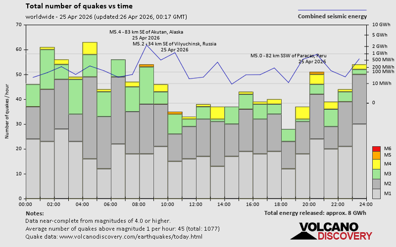 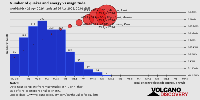 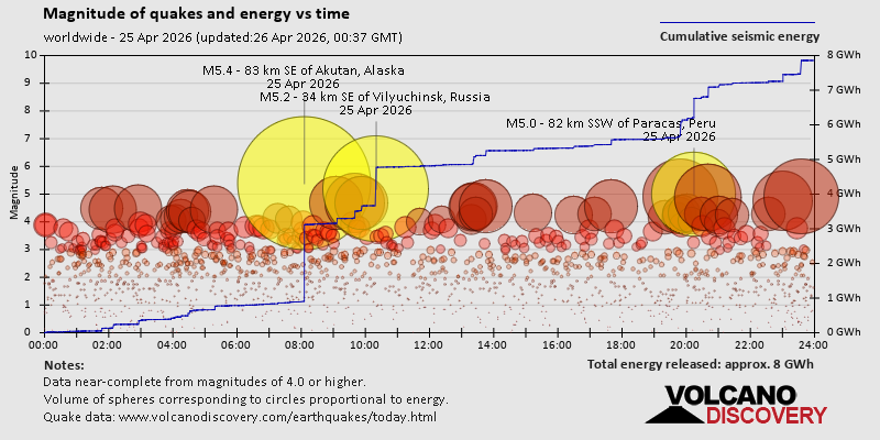 https://www.volcanodiscovery.com/earthquake/news/300674/World-Earthquake-Report-for-Saturday-25-April-2026.html https://www.volcanodiscovery.com/earthquake/news/300674/World-Earthquake-Report-for-Saturday-25-April-2026.html
0
8
Read More
|
Significant magnitude 5.2 earthquake 43 km southwest of Ica, Peru
Webmaster
Yesterday at 08:25 PM
Significant magnitude 5.2 earthquake 43 km southwest of Ica, Peru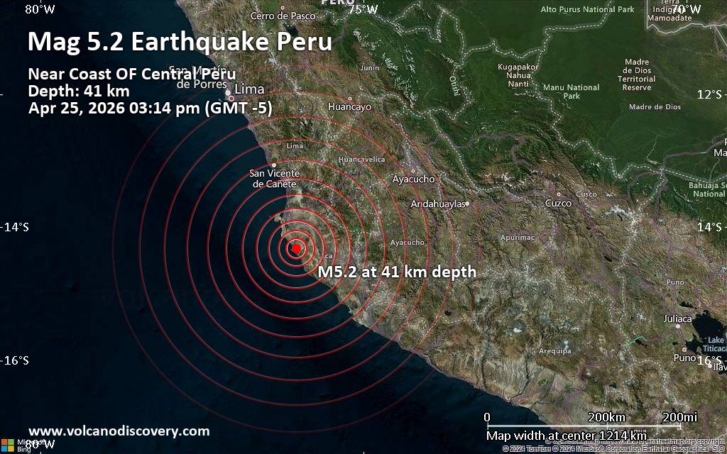 A moderately shallow magnitude 5.2 earthquake was reported early afternoon near Ica, Ica Province, Peru.
According to the European-Mediterranean Seismological Centre (EMSC), the quake hit on Saturday, April 25th, 2026, at 3:14 pm local time at a moderately shallow depth of 41. km. The exact magnitude, epicenter, and depth of the quake might be revised within the next few hours or minutes as seismologists review data and refine their calculations, or as other agencies issue their report.
A second report was later issued by the citizen-seismograph network of RaspberryShake, which listed it as a magnitude 5.2 earthquake as well. A third agency, the German Research Centre for Geosciences (GFZ), reported the same quake at magnitude 5.2.
Based on the preliminary seismic data, the quake should not have caused any significant damage, but was probably felt by many people as light vibration in the area of the epicenter.
Weak shaking might have been felt in Santiago (pop. 10,400) located 38 km from the epicenter, Ica (pop. 282,400) 43 km away, Los Aquijes (pop. 7,800) 45 km away, Subtanjalla (pop. 9,100) 46 km away, Fonavi (pop. 6,700) 46 km away, San Juan Bautista (pop. 6,900) 48 km away, Pisco (pop. 61,900) 71 km away, and San Clemente (pop. 15,800) 75 km away.
VolcanoDiscovery will automatically update magnitude and depth if these change and follow up if other significant news about the quake become available. If you’re in the area, please send us your experience through our reporting mechanism, either online or via our mobile app. This will help us provide more first-hand updates to anyone around the globe who wants to know more about this quake.
Earthquake data: Date & time: Apr 25, 2026 03:14 pm (Lima time) local time (25 Apr 2026 20:14 GMT)Magnitude: 5.2 Depth: 41.00 km Epicenter latitude / longitude: 14.33°S / 76.04°W  ( Ica, Peru) Primary data source: EMSChttps://www.volcanodiscovery.com/earthquake/news/300711/Significant-magnitude-52-earthquake-43-km-southwest-of-Ica-Peru.html
0
7
Read More
|
World Earthquake Report for April 2026
Webmaster
Yesterday at 06:00 PM
World Earthquake Report for April 2026 Worldwide earthquakes above magnitude 5.5 during April 2026 Magnitude 9+: none Magnitude 8+: none Magnitude 7+: 2 earthquakes Magnitude 6+: 5 earthquakes Magnitude 5+: 163 earthquakes Magnitude 4+: 1178 earthquakes Magnitude 3+: 5800 earthquakes Magnitude 2+: 10415 earthquakes No quakes of magnitude 8 or higher List of 10 largest earthquakes in the world during April 2026:Thursday, Apr 2, 2026, at 07:48 am (Jayapura time) - Thursday, Apr 2, 2026, at 12:23 pm (Jayapura time) - Wednesday, Apr 1, 2026, at 06:20 am (Lima time) - Friday, Apr 17, 2026, at 01:30 am (GMT +12) - Saturday, Apr 4, 2026, at 06:34 pm (GMT +8) - Thursday, Apr 2, 2026, at 11:13 pm (Jayapura time) - Monday, Apr 6, 2026, at 02:18 am (GMT -9) - Saturday, Apr 4, 2026, at 10:35 am (Jayapura time) - Thursday, Apr 2, 2026, at 11:34 pm (Jayapura time) - Friday, Apr 3, 2026, at 08:42 pm (GMT +4:30) - Earthquake stats:   https://www.volcanodiscovery.com/view_news/299131/World-Earthquake-Report-for-April-2026.html https://www.volcanodiscovery.com/view_news/299131/World-Earthquake-Report-for-April-2026.html
0
3
Read More
|
Small 3.9 quake hits near Kalifornsky, Kenai Peninsula, Alaska, USA
Webmaster
Yesterday at 12:40 PM
Small 3.9 quake hits near Kalifornsky, Kenai Peninsula, Alaska, USA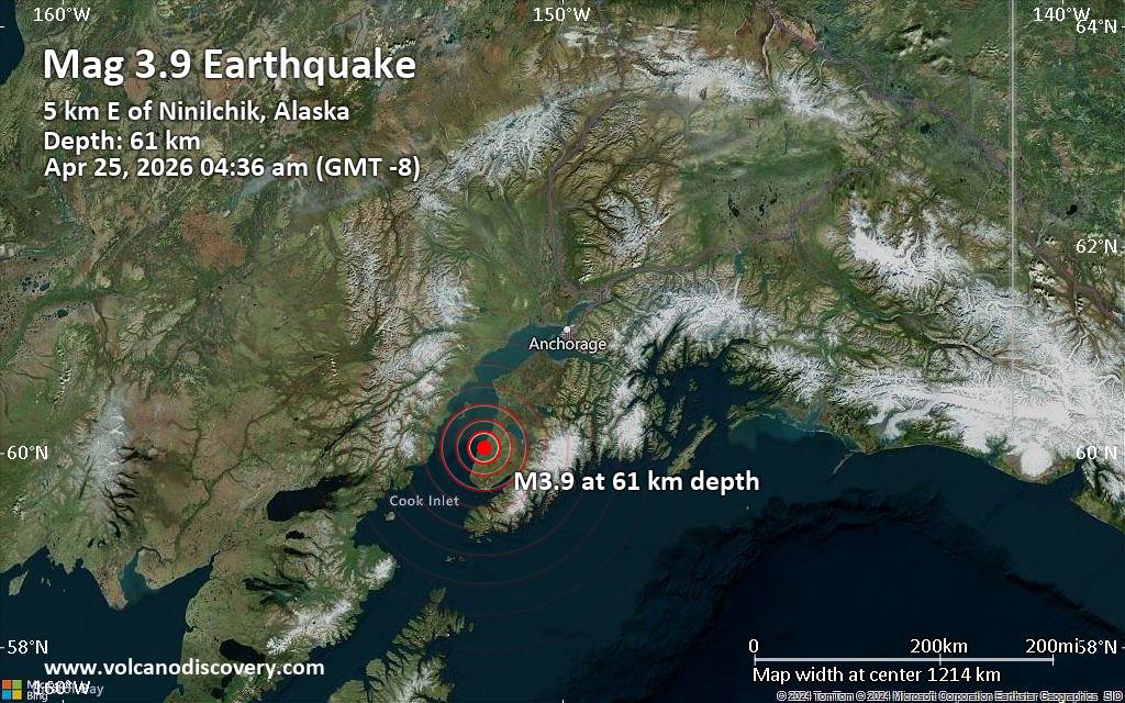 The United States Geological Survey reported a magnitude 3.9 quake in the United States near Kalifornsky, Kenai Peninsula, Alaska, only 2 minutes ago. The earthquake hit early morning on Saturday, April 25th, 2026, at 4:36 am local time at a moderately shallow depth of 38 miles. The exact magnitude, epicenter, and depth of the quake might be revised within the next few hours or minutes as seismologists review data and refine their calculations, or as other agencies issue their report.
A second report was later issued by The Incorporated Research Institutions for Seismology (IRIS), which listed it as a magnitude 3.9 earthquake as well. A third agency, the European-Mediterranean Seismological Centre (EMSC), reported the same quake at magnitude 3.9.
Towns or cities near the epicenter where the quake might have been felt as very weak shaking include Ninilchik (pop. 880) located 4 miles from the epicenter, Anchor Point (pop. 1,900) 21 miles away, Fritz Creek (pop. 1,900) 24 miles away, Cohoe (pop. 1,400) 24 miles away, Kalifornsky (pop. 7,900) 27 miles away, Homer (pop. 5,500) 28 miles away, Soldotna (pop. 4,500) 35 miles away, and Kenai (pop. 7,700) 36 miles away.
Earthquake data: Date & time: Apr 25, 2026 12:36 pm (Universal Time) local time (25 Apr 2026 12:36 GMT)Magnitude: 3.9 Depth: 54.70 km Epicenter latitude / longitude: 60.07°N / 151.53°W ( Kenai Peninsula Borough, Alaska, United States) Primary data source: USGShttps://www.volcanodiscovery.com/earthquake/news/300701/Small-39-quake-hits-near-Kalifornsky-Kenai-Peninsula-Alaska-USA.html
0
8
Read More
|
Small 3.9 quake hits near Castrovillari, Province of Cosenza, Calabria, Italy
Webmaster
Yesterday at 11:49 AM
Small 3.9 quake hits near Castrovillari, Province of Cosenza, Calabria, Italy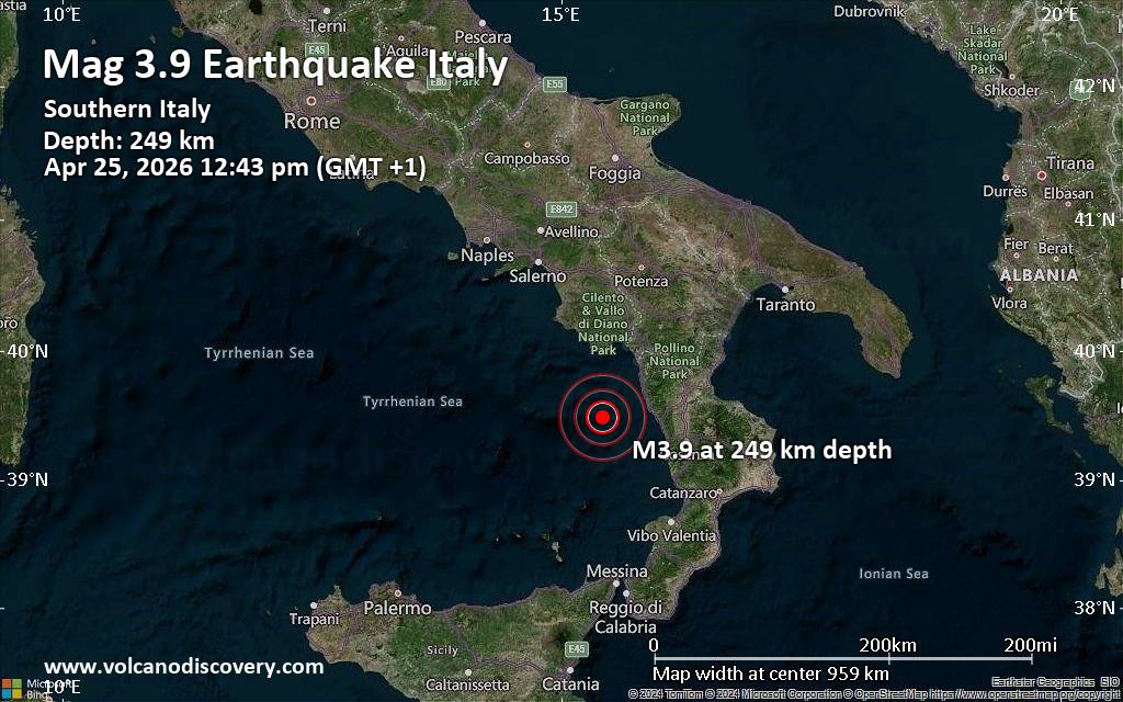 The German Research Centre for Geosciences (GFZ) reported a magnitude 3.9 quake in Italy near Castrovillari, Province of Cosenza, Calabria, only 5 minutes ago. The earthquake hit around noon on Saturday, April 25th, 2026, at 12:43 pm local time at an intermediate to considerable depth of 249. km. The exact magnitude, epicenter, and depth of the quake might be revised within the next few hours or minutes as seismologists review data and refine their calculations, or as other agencies issue their report.
A second report was later issued by the citizen-seismograph network of RaspberryShake, which listed it as a magnitude 3.9 earthquake as well.
According to preliminary calculations, we do not expect that the quake was felt by many people and did not cause any damage. In Serluca-Calabaia Isola Polazza (pop. 150, 41 km away), Diamante (pop. 3,100, 41 km away), Belvedere Marittimo (pop. 6,200, 41 km away), Cetraro Marina (pop. 4,000, 45 km away), Marcellina (pop. 2,000, 47 km away), Scalea (pop. 9,300, 48 km away), Praia a Mare (pop. 6,500, 55 km away), Paola (pop. 12,600, 56 km away), and Castrovillari (pop. 20,300, 77 km away), the quake was probably not felt.
Earthquake data: Date & time: Apr 25, 2026 12:43 pm (GMT +1) local time (25 Apr 2026 11:43 GMT)Magnitude: 3.9 Depth: 249.00 km Epicenter latitude / longitude: 39.49°N / 15.41°E  ( Calabria, Italy) Primary data source: GFZhttps://www.volcanodiscovery.com/earthquake/news/300697/Small-39-quake-hits-near-Castrovillari-Province-of-Cosenza-Calabria-Italy.html
0
7
Read More
|
Significant 5.3 quake hits near Unalaska, Aleutians West, Alaska, USA
Webmaster
Yesterday at 08:16 AM
Significant 5.3 quake hits near Unalaska, Aleutians West, Alaska, USA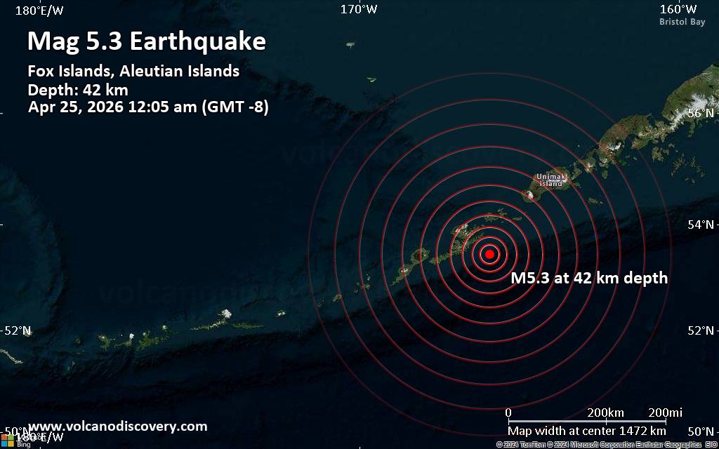 Just 9 minutes ago, a 5.3-magnitude earthquake struck near Unalaska, Aleutians West, Alaska, USA. The tremor was recorded after midnight on Saturday, April 25th, 2026, at 12:05 am local time, at a moderately shallow depth of 26 miles below the surface.
The event was filed by the European-Mediterranean Seismological Centre (EMSC), the first seismological agency to report it.
Our monitoring service identified a second report from the citizen-seismograph network of RaspberryShake which listed the quake at magnitude 5.3 as well. A third agency, the German Research Centre for Geosciences (GFZ), reported the same quake at magnitude 5.3.
Based on the preliminary seismic data, the quake should not have caused any significant damage, but was probably felt by many people as light vibration in the area of the epicenter.
Weak shaking might have been felt in Unalaska (pop. 4,500) located 39 miles from the epicenter, Dutch Harbor (pop. 4,400) 40 miles away, and Akutan (pop. 1000) 48 miles away.
VolcanoDiscovery will automatically update magnitude and depth if these change and follow up if other significant news about the quake become available. If you’re in the area, please send us your experience through our reporting mechanism, either online or via our mobile app. This will help us provide more first-hand updates to anyone around the globe who wants to know more about this quake.
Earthquake data: Date & time: Apr 25, 2026 12:05 am (GMT -8) local time (25 Apr 2026 08:05 GMT)Magnitude: 5.4 Depth: 35.00 km Epicenter latitude / longitude: 53.59°N / 164.91°W (Aleutians West, Alaska, United States) Primary data source: USGShttps://www.volcanodiscovery.com/earthquake/news/300687/Significant-53-quake-hits-near-Unalaska-Aleutians-West-Alaska-USA.html
0
7
Read More
|
Magnitude 3.8 earthquake strikes near Eureka, Humboldt County, California, USA
Webmaster
Yesterday at 07:43 AM
Magnitude 3.8 earthquake strikes near Eureka, Humboldt County, California, USA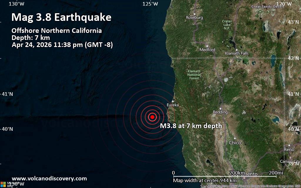 The European-Mediterranean Seismological Centre (EMSC) reported a magnitude 3.8 quake in the United States near Eureka, Humboldt County, California, only 4 minutes ago. The earthquake hit late at night on Friday, April 24th, 2026, at 11:38 pm local time at a very shallow depth of 4.6 miles. The exact magnitude, epicenter, and depth of the quake might be revised within the next few hours or minutes as seismologists review data and refine their calculations, or as other agencies issue their report.
Towns or cities near the epicenter where the quake might have been felt as very weak shaking include Ferndale (pop. 1,400) located 38 miles from the epicenter, Fortuna (pop. 12,000) 44 miles away, Rio Dell (pop. 3,400) 45 miles away, and Humboldt Hill (pop. 3,400) 47 miles away. In Eureka (pop. 27,000, 51 miles away), Myrtletown (pop. 4,700, 52 miles away), Bayside (pop. 17,100, 57 miles away), and Arcata (pop. 17,800, 57 miles away), the quake was probably not felt.
Earthquake data: Date & time: Apr 25, 2026 07:38 am (Universal Time) local time (25 Apr 2026 07:38 GMT)Magnitude: 3.8 Depth: 7.43 km Epicenter latitude / longitude: 40.35°N / 124.93°W ( California, United States) Primary data source: USGShttps://www.volcanodiscovery.com/earthquake/news/300685/Magnitude-38-earthquake-strikes-near-Eureka-Humboldt-County-California-USA.html
0
7
Read More
|
Small earthquake of magnitude 3.6 reported 22 miles south of Oxford, Mississippi, United States
Webmaster
Yesterday at 04:34 AM
Small earthquake of magnitude 3.6 reported 22 miles south of Oxford, Mississippi, United States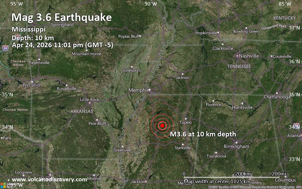 A shallow magnitude 3.6 earthquake was reported late at night near Oxford, Lafayette County, Mississippi, USA.
According to the European-Mediterranean Seismological Centre (EMSC), the quake hit on Friday, April 24th, 2026, at 11:01 pm local time at a shallow depth of 6.2 miles. Shallow earthquakes are felt more strongly than deeper ones as they are closer to the surface. Magnitude and other quake parameters can still change in the coming hours as the agency continues to process seismic data.
Based on the preliminary seismic data, the quake should not have caused any significant damage, but was probably felt by many people as light vibration in the area of the epicenter.
Weak shaking might have been felt in Coffeeville (pop. 870) located 8 miles from the epicenter, and Water Valley (pop. 3,400) 8 miles away.
Other towns or cities near the epicenter where the quake might have been felt as very weak shaking include Bruce (pop. 1,900) located 13 miles from the epicenter, Calhoun City (pop. 1,700) 20 miles away, Oxford (pop. 22,300) 22 miles away, Grenada (pop. 12,900) 23 miles away, and Batesville (pop. 7,400) 28 miles away. In Greenwood (pop. 15,400, 51 miles away), the quake was probably not felt.
Earthquake data: Date & time: Apr 24, 2026 11:01 pm (GMT -5) local time (25 Apr 2026 04:01 GMT)Magnitude: 3.6 Depth: 10.00 km Epicenter latitude / longitude: 34.05°N / 89.57°W ( Yalobusha County, Mississippi, United States) Primary data source: EMSChttps://www.volcanodiscovery.com/earthquake/news/300668/Small-earthquake-of-magnitude-36-reported-22-miles-south-of-Oxford-Mississippi-United-States.html
0
6
Read More
|
Small 3.8 quake hits near Lugo, Galicia, Spain
Webmaster
Yesterday at 01:46 AM
Small 3.8 quake hits near Lugo, Galicia, Spain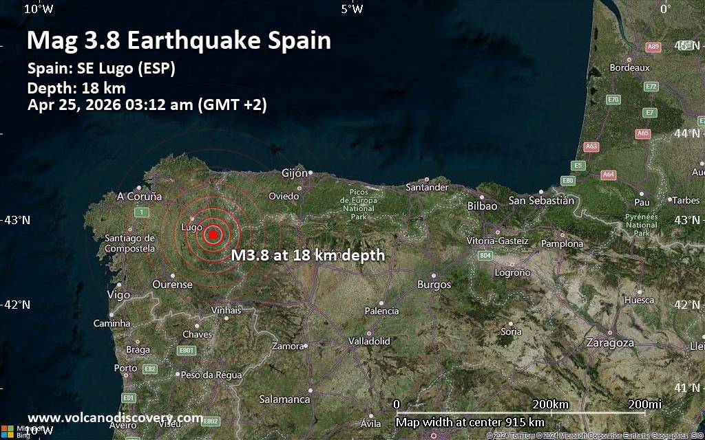 Just 32 minutes ago, a 3.8-magnitude earthquake struck near Lugo, Galicia, Spain. The tremor was recorded early morning on Saturday, April 25th, 2026, at 3:12 am local time, at a shallow depth of 18. km below the surface.
The event was filed by the Portuguese Institute for Sea and Atmosphere (Instituto Português do Mar e da Atmosfera, IPMA), the first seismological agency to report it.
A second report was later issued by the citizen-seismograph network of RaspberryShake, which listed it as a magnitude 3.8 earthquake as well.
Based on the preliminary seismic data, the quake should not have caused any significant damage, but was probably felt by many people as light vibration in the area of the epicenter.
Weak shaking might have been felt in Sobrerriba (pop. 15) located 3 km from the epicenter, Becerrea (pop. 3,400) 6 km away, Baralla (pop. 3,100) 8 km away, Lancara (pop. 3,100) 10 km away, and Sarria (pop. 13,500) 16 km away.
Other towns or cities near the epicenter where the quake might have been felt as very weak shaking include Lugo (pop. 98,000) located 34 km from the epicenter, Monforte de Lemos (pop. 19,500) 41 km away, Ponferrada (pop. 68,700) 60 km away, and Ourense (pop. 105,200) 75 km away.
Earthquake data: Date & time: Apr 25, 2026 03:12 am (GMT +2) local time (25 Apr 2026 01:12 GMT)Magnitude: 3.8 Depth: 18.00 km Epicenter latitude / longitude: 42.82°N / 7.23°W  ( Lugo, Galicia, Spain) Primary data source: IPMAhttps://www.volcanodiscovery.com/earthquake/news/300658/Small-38-quake-hits-near-Lugo-Galicia-Spain.html
0
8
Read More
|
Small 3.1 quake hits near Lugo, Galicia, Spain
Webmaster
Yesterday at 01:25 AM
Small 3.1 quake hits near Lugo, Galicia, Spain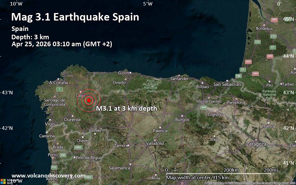 An earthquake of magnitude 3.1 occurred early morning on Saturday, April 25th, 2026, at 3:10 am local time near Lugo, Galicia, Spain, as reported by the European-Mediterranean Seismological Centre (EMSC).
According to preliminary data, the quake was located at a very shallow depth of 2.60 km. Shallow earthquakes are felt more strongly than deeper ones as they are closer to the surface. The exact magnitude, epicenter, and depth of the quake might be revised within the next few hours or minutes as seismologists review data and refine their calculations, or as other agencies issue their report.
A second report was later issued by Spain's Instituto Geográfico Nacional (IGN), which listed it as a magnitude 3.1 earthquake as well. A third agency, the citizen-seismograph network of RaspberryShake, reported the same quake at magnitude 3.1.
Based on the preliminary seismic data, the quake should not have caused any significant damage, but was probably felt by many people as light vibration in the area of the epicenter.
Weak shaking might have been felt in Triacastela (pop. 830) located 3 km from the epicenter.
Other towns or cities near the epicenter where the quake might have been felt as very weak shaking include Becerrea (pop. 3,400) located 11 km from the epicenter, Lancara (pop. 3,100) 12 km away, Baralla (pop. 3,100) 12 km away, and Sarria (pop. 13,500) 14 km away. In Lugo (pop. 98,000, 36 km away), Monforte de Lemos (pop. 19,500, 36 km away), Ponferrada (pop. 68,700, 59 km away), and Ourense (pop. 105,200, 71 km away), the quake was probably not felt.
Earthquake data: Date & time: Apr 25, 2026 03:10 am (GMT +2) local time (25 Apr 2026 01:10 GMT)Magnitude: 3.1 Depth: 2.60 km Epicenter latitude / longitude: 42.78°N / 7.25°W ( Lugo, Galicia, Spain) Primary data source: EMSChttps://www.volcanodiscovery.com/earthquake/news/300656/Small-31-quake-hits-near-Lugo-Galicia-Spain.html
0
8
Read More
|
|
Forums60
Topics770,274
Posts805,054
Members2,958
| |
Most Online17,963
Jan 15th, 2026
|
|
|
|
|
Copyright 1996 - 2026 by David Cottle. Designed by David Bate Jr. All Rights Reserved.
By using this forum, the user agrees not to transfer any data or technical information received under the agreement, to any other entity without the express approval of the AUS-CITY Forum Admins and/or authors of individual posts (Forum Admins and DoD/USSPACECOM for the analysis of satellite tracking data).
Two-line elements (TLE) and all other satellite data presented and distributed via this forum and e-mail lists of AUS-CITY are distributed with permission from DoD/USSTRATCOM.


Reprise Hosting

|

|


 - Click image for larger picture.")


