|
|
|
0 members (),
563
guests, and
27
robots. |
|
Key:
Admin,
Global Mod,
Mod
|
|
S |
M |
T |
W |
T |
F |
S |
|
|
|
1
|
2
|
3
|
4
|
5
|
|
6
|
7
|
8
|
9
|
10
|
11
|
12
|
|
13
|
14
|
15
|
16
|
17
|
18
|
19
|
|
20
|
21
|
22
|
23
|
24
|
25
|
26
|
|
27
|
28
|
29
|
30
|
31
|
|
|
|
There are no members with birthdays on this day. |
 SPC Jul 25, 2025 1300 UTC Day 1 Convective Outlook
Webmaster
2 hours ago
SPC Jul 25, 2025 1300 UTC Day 1 Convective Outlook
Webmaster
2 hours ago
SPC Jul 25, 2025 1300 UTC Day 1 Convective OutlookSPC 1300Z Day 1 Outlook 
Day 1 Convective Outlook
NWS Storm Prediction Center Norman OK
0753 AM CDT Fri Jul 25 2025

Valid 251300Z - 261200Z

...THERE IS A SLIGHT RISK OF SEVERE THUNDERSTORMS THIS AFTERNOON AND
EVENING FOR MUCH OF NORTH DAKOTA...AND FOR PORTIONS OF SOUTHERN NEW
ENGLAND INTO THE NORTHERN MID-ATLANTIC REGION...

...SUMMARY...
Scattered strong to severe thunderstorms will pose a risk of
damaging wind gusts across parts of New England and the northern Mid
Atlantic later today. Severe storms will also be possible across
much of North Dakota.

...Northeast States...
Morning water vapor imagery shows a fast-moving shortwave trough
progressing eastward across Ontario.  The associated cold front will
move through the St Lawrence Valley this morning and southward
across New England this afternoon.  Relatively hot/humid conditions
ahead of the front will lead to widely scattered afternoon
thunderstorms across southern New England and eastern NY/PA.  These
storms will track southeastward toward the coast through the early
evening.  Coverage of intense storms is uncertain, but conditions
will be favorable for gusty/damaging winds in the cells that form.

...Northern Plains...
An upper ridge remains centered over the central Plains, with a weak
southern-stream trough currently moving across UT into WY.  Weak
lift and increased mid-level moisture ahead of the system will aid
in the development of scattered thunderstorms by late afternoon
across parts of eastern MT/northeast WY.  Thermodynamic parameters
appear favorable for large hail in the stronger cells. Model
guidance varies on handling this activity as it spreads eastward.
However, it appears reasonable that portions of this early activity
will persist through the evening and pose a risk of hail and locally
damaging winds across parts of ND. Later CAM solutions will
hopefully help better focus this threat area.

...KS/MO...
A large area of overnight convection has resulted in a
convectively-aided shortwave trough that will move into eastern KS
this afternoon.  Thunderstorms will likely re-develop near/east of
the remnant MCV and track into western MO during the evening.
Assuming sufficient heating can occur this afternoon along the
southeastern edge of the remnant clouds, a corridor of MRGL severe
threat will likely develop.  Isolated damaging wind gusts would be
the main concern.

..Hart/Grams.. 07/25/2025
Read morehttps://www.spc.noaa.gov/products/outlook/day1otlk_1300.html
0
4
Read More
|
World Earthquake Report for Friday, 25 July 2025
Webmaster
6 hours ago
World Earthquake Report for Friday, 25 July 2025 Worldwide earthquakes above magnitude 3 during the past 24 hours on 25 Jul 2025 Magnitude 6+: 2 earthquakes Magnitude 5+: 8 earthquakes Magnitude 4+: 56 earthquakes Magnitude 3+: 144 earthquakes Magnitude 2+: 345 earthquakes No quakes of magnitude 7 or higher 10 largest earthquakes in the world (past 24 hours)Friday, Jul 25, 2025, at 11:37 am (GMT +12) - Friday, Jul 25, 2025, at 09:37 am (GMT +11) - Friday, Jul 25, 2025, at 09:39 am (GMT +11) - Friday, Jul 25, 2025, at 02:37 am (GMT +10) - Thursday, Jul 24, 2025, at 09:07 pm (GMT +8) - Friday, Jul 25, 2025, at 02:31 am (GMT +1) - Thursday, Jul 24, 2025, at 09:08 pm (GMT +8) - Friday, Jul 25, 2025, at 10:38 am (GMT +11) - Friday, Jul 25, 2025, at 05:22 am (GMT +10) - Friday, Jul 25, 2025, at 12:29 am (GMT -1) - Earthquakes reported feltFriday, Jul 25, 2025, at 08:31 am (GMT +3) - Friday, Jul 25, 2025, at 02:31 am (GMT +1) - Thursday, Jul 24, 2025, at 09:07 pm (GMT +8) - Friday, Jul 25, 2025, at 02:37 am (GMT +10) - Friday, Jul 25, 2025, at 12:29 am (GMT -1) - Thursday, Jul 24, 2025, at 07:11 pm (GMT -6) - Thursday, Jul 24, 2025, at 06:43 pm (GMT -6) - Friday, Jul 25, 2025, at 11:17 am (GMT +9) - Friday, Jul 25, 2025, at 09:37 am (GMT +11) - Thursday, Jul 24, 2025, at 03:58 pm (GMT +2) - Thursday, Jul 24, 2025, at 10:14 pm (GMT -6) - Friday, Jul 25, 2025, at 03:40 am (GMT +6) - Friday, Jul 25, 2025, at 06:31 am (Istanbul time) - Thursday, Jul 24, 2025, at 01:39 pm (GMT -5) - Thursday, Jul 24, 2025, at 05:23 am (GMT -8) - Thursday, Jul 24, 2025, at 10:18 pm (GMT -5) - Thursday, Jul 24, 2025, at 10:39 pm (GMT +11) - Friday, Jul 25, 2025, at 09:11 am (GMT +2) - Thursday, Jul 24, 2025, at 02:46 pm (GMT -4) - Friday, Jul 25, 2025, at 11:22 am (GMT +11) - Friday, Jul 25, 2025, at 02:31 am (GMT +1) - Friday, Jul 25, 2025, at 12:16 pm (GMT +9) - Friday, Jul 25, 2025, at 01:33 am (GMT +8) - Thursday, Jul 24, 2025, at 11:31 pm (GMT -5) - Thursday, Jul 24, 2025, at 11:11 am (GMT -6) - Thursday, Jul 24, 2025, at 08:37 pm (GMT -5) - Friday, Jul 25, 2025, at 09:39 am (GMT +11) - Friday, Jul 25, 2025, at 10:27 am (GMT +11) - Thursday, Jul 24, 2025, at 09:39 pm (GMT +7) - Thursday, Jul 24, 2025, at 07:54 pm (GMT -5) - Thursday, Jul 24, 2025, at 11:05 pm (GMT -4) - Earthquake stats   https://www.volcanodiscovery.com/earthquake/news/276437/World-Earthquake-Report-for-Friday-25-July-2025.html https://www.volcanodiscovery.com/earthquake/news/276437/World-Earthquake-Report-for-Friday-25-July-2025.html
0
9
Read More
|
SPC Jul 25, 2025 Day 4-8 Severe Weather Outlook
Webmaster
6 hours ago
SPC Jul 25, 2025 Day 4-8 Severe Weather OutlookDay 4-8 Outlook 
Day 4-8 Convective Outlook
NWS Storm Prediction Center Norman OK
0355 AM CDT Fri Jul 25 2025

Valid 281200Z - 021200Z

...DISCUSSION...
The strongest mid-level flow will move from the Upper Midwest into
the Northeast this weekend into the middle of next week. As this
occurs, a surface boundary will slowly sag into the central Plains
and Ohio Valley. Given the very moist airmass to the south of the
boundary, strong to potentially severe storms are possible along the
boundary at least into the middle of next week. With the stronger
flow/shear displace north of the boundary and model differences in
the location, uncertainty remains too high for highlights.

Farther west, moisture will be pushed up against parts of the
northern Rockies and adjacent High Plains. Between the terrain and
shortwave troughs moving through the central U.S. ridge, it is
possible strong to severe storms could develop and progress along
the surface boundary into greater areas of moisture/buoyancy in the
Plains. Given the dependency on the low-predictability shortwaves,
it is not clear where the greatest risk will be from the High Plains
into the Plains through the middle of next week.

By the end of next week, model guidance suggests a general trend of
continued upper ridge building into Plains. Stronger mid-level winds
will remain in parts of the Northeast with additional shortwave
perturbations moving through parts of the northern Rockies. Severe
risk along the boundary should decrease as it becomes further
removed from the stronger flow. Though predictability is low
regarding the shortwave troughs, some severe risk could develop in
parts of the northern Rockies.
Read morehttps://www.spc.noaa.gov/products/exper/day4-8/
0
4
Read More
|
Volcano earthquake report for Friday, 25 Jul 2025
Webmaster
6 hours ago
Volcano earthquake report for Friday, 25 Jul 2025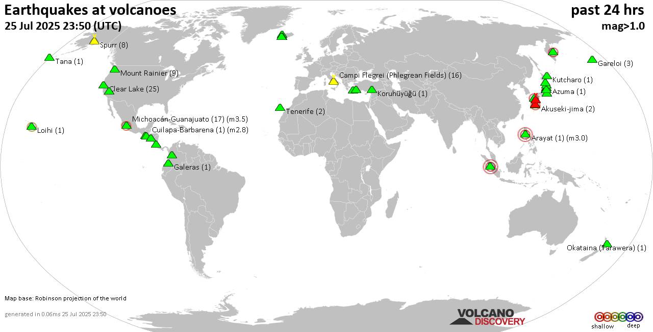 World map showing volcanoes with shallow (less than 50 km) earthquakes within 20 km radius during the past 24 hours on 25 Jul 2025 Number in brackets indicate nr of quakes. Quakes detected near: Agua (3 quakes between mag 1.9-3.5), Akuseki-jima (1 quake mag 2.1), Arenal (1 quake mag 2.0), Barva (1 quake mag 3.3), Campi Flegrei (Phlegrean Fields) (18 quakes between mag 0.1-3.0), Cerro Bravo (1 quake mag 1.8)
Clear Lake (15 quakes between mag 0.7-1.6), Coso (2 quakes between mag 0.2-1.0), Daisen (1 quake mag 1.3), El Chichón (5 quakes between mag 1.9-3.0), Gareloi (4 quakes between mag 1.7-2.8), Hrómundartindur (2 quakes between mag 0.4-1.3), Isla El Tigre (1 quake mag 3.5), Kolumbo (4 quakes between mag 1.3-2.0), Koruhüyüğü (1 quake mag 1.8), Krísuvík (2 quakes between mag 0.3-1.2), Ljósufjöll (5 quakes between mag 0.8-1.6), Mahagnao (1 quake mag 2.6), Michoacán-Guanajuato (9 quakes between mag 2.5-3.3), Mount Rainier (8 quakes between mag 0.1-1.0), Nantai (2 quakes between mag 0.6-1.1), Okataina (Tarawera) (1 quake mag 1.4), Osore-yama (3 quakes between mag 0.4-1.2), Papandayan (1 quake mag 2.5), Platanar (1 quake mag 1.8), Sanbe (2 quakes between mag 2.7-2.8), Spurr (11 quakes between mag 0.1-2.2), Suwanose-jima (3 quakes between mag 1.5-2.0), Talang (4 quakes between mag 2.5-3.2), Taupo (1 quake mag 1.0), To-shima (2 quakes between mag 1.0-1.2), Unzen (34 quakes between mag 0.2-2.9), Yellowstone (1 quake mag 3.0) (updated 08h50)
Note: Earthquakes within 20 km from and at depths less than 50 km under active volcanoes are reported. The list is not complete because many volcanoes are not monitored and/or seismic data in high resolution is not available publicly.
Volcanoes with recent earthquakes above magnitude 2 or more than 10 quakes are listed below:
Agua volcano (Guatemala): 3 earthquakes up to magnitude 3.53 earthquakes occurred near (under) the volcano during 1 hour 9 minutes, the last being recorded quake 6 hours ago. Hypocenter depths ranged between 10.00 and 6.00 km. Earthquake details: 3.5 quake Departamento de Sacatepequez, 20 km southwest of Guatemala City, Guatemala, Jul 24, 2025 07:11 pm (GMT -6) (11 km NE) Reported seismic-like event (likely no quake): 33 km southwest of Villa Nueva, Departamento de Guatemala, Guatemala, Jul 24, 2025 08:09 pm (GMT -6) (18 km SSW) 1.9 quake 8.9 km southeast of Antigua Guatemala, Departamento de Sacatepequez, Guatemala, Jul 24, 2025 08:20 pm (GMT -6) (9 km ENE) All earthquakes at AguaAkuseki-jima volcano (Ryukyu Islands): magnitude 2.1 earthquakeA magnitude 2.1 earthquake occurred at the volcano 5 hours ago. The quake, which might be volcanic in origin, was located at a depth of 0 km depth at 16 km distance SSW from the volcano. Earthquake details: 2.1 quake East China Sea, Kagoshima-ken, 38 km southwest of Suwanose-jima Island, Japan, Jul 25, 2025 12:51 pm (GMT +9) (16 km SSW) All earthquakes at Akuseki-jimaBarva volcano (Costa Rica): magnitude 3.3 earthquakeA magnitude 3.3 earthquake occurred at the volcano 22 hours ago. The quake, which might be volcanic in origin, was located at a depth of 8.00 km depth at 15 km distance SE from the volcano. Earthquake details: 3.3 quake Provincia de Heredia, 15 km northeast of San Jose, Costa Rica, Jul 24, 2025 04:39 am (GMT -6) (15 km SE) All earthquakes at BarvaCampi Flegrei (Phlegrean Fields) volcano (Italy): 18 earthquakes up to magnitude 3.0Possible earthquake swarm: 18 earthquakes occurred near (under) the volcano during 20 hours, the last being recorded quake 3 hours ago. Hypocenter depths ranged between 10.00 and 0.01 km. Earthquake details: (only 5 largest) Reported seismic-like event (likely no quake): 15 km west of Naples, Napoli, Campania, Italy, Jul 24, 2025 04:27 pm (GMT +2) (8 km NNW) 1.4 quake 4.1 km southeast of Pozzuoli, Napoli, Campania, Italy, Jul 25, 2025 07:12 am (GMT +2) (1 km SW) 1.2 quake 4.5 km southeast of Pozzuoli, Napoli, Campania, Italy, Jul 25, 2025 06:36 am (GMT +2) (1 km SSE) 0.8 quake Italy: Flegrei Jul 24, 2025 10:27 pm (GMT +2) (1 km WSW) 0.7 quake 2.7 km northwest of Bagnoli, Napoli, Campania, Italy, Jul 25, 2025 12:49 am (GMT +2) (1 km S) All earthquakes at Campi Flegrei (Phlegrean Fields)Clear Lake volcano (California): 15 earthquakes up to magnitude 1.6Possible earthquake swarm: 15 earthquakes occurred near (under) the volcano during 23 hours, the last being recorded quake 23 minutes ago. Hypocenter depths ranged between 3.05 and 0.30 km. Earthquake details: (only 5 largest) 1.6 quake Sonoma County, 13 mi southwest of Clearlake, Lake County, California, United States, Jul 24, 2025 10:22 pm (GMT -7) (16 km SSW) 1.5 quake 27 mi north of Santa Rosa, Sonoma County, California, United States, Jul 25, 2025 01:27 am (GMT -7) (17 km S) 1.5 quake 8 km WNW of Cobb, CA, Jul 24, 2025 06:22 pm (GMT -7) (16 km SSW) 1.4 quake Lake County, 27 mi north of Santa Rosa, Sonoma County, California, United States, Jul 24, 2025 05:03 pm (GMT -7) (16 km S) 1.3 quake 27 mi north of Santa Rosa, Sonoma County, California, United States, Jul 24, 2025 09:53 am (GMT -7) (17 km S) All earthquakes at Clear LakeEl Chichón volcano (Southern Mexico): 5 earthquakes up to magnitude 3.05 earthquakes occurred near (under) the volcano during 4 hours, the last being recorded quake 11 hours ago. Hypocenter depths ranged between 2.00 and 1.90 km. Earthquake details: 3.0 quake Estado de Chiapas, 36 km southwest of Teapa, Estado de Tabasco, Mexico, Jul 24, 2025 12:56 pm (GMT -6) (1 km NW) 2.8 quake Estado de Chiapas, 36 km southwest of Teapa, Estado de Tabasco, Mexico, Jul 24, 2025 12:21 pm (GMT -6) (0 km NNE) 2.7 quake Estado de Chiapas, 37 km southwest of Teapa, Estado de Tabasco, Mexico, Jul 24, 2025 04:17 pm (GMT -6) (1 km WSW) 2.6 quake Estado de Chiapas, 36 km southwest of Teapa, Estado de Tabasco, Mexico, Jul 24, 2025 11:59 am (GMT -6) (0 km N) 1.9 quake Estado de Chiapas, 36 km southwest of Teapa, Estado de Tabasco, Mexico, Jul 24, 2025 03:28 pm (GMT -6) (1 km NNW) All earthquakes at El ChichónGareloi volcano (Aleutian Islands): 4 earthquakes up to magnitude 2.84 earthquakes occurred near (under) the volcano during 9 hours, the last being recorded quake 10 hours ago. Hypocenter depths ranged between 9.99 and 8.35 km. Earthquake details: 2.8 quake Bering Sea, 32 mi north of Amatignak Island, Aleutians West Census Area, Alaska, United States, Jul 24, 2025 02:14 pm (GMT -9) (19 km WSW) 2.4 quake Bering Sea, 32 mi north of Amatignak Island, Aleutians West Census Area, Alaska, United States, Jul 24, 2025 10:54 am (GMT -9) (19 km WSW) 1.7 quake Bering Sea, 32 mi north of Amatignak Island, Aleutians West Census Area, Alaska, United States, Jul 24, 2025 11:29 am (GMT -9) (19 km WSW) 1.7 quake Bering Sea, 32 mi north of Amatignak Island, Aleutians West Census Area, Alaska, United States, Jul 24, 2025 05:11 am (GMT -9) (19 km WSW) All earthquakes at GareloiIsla El Tigre volcano (Honduras): magnitude 3.5 earthquakeA magnitude 3.5 earthquake occurred at the volcano 6 hours ago. The quake, which might be volcanic in origin, was located at a depth of 5.40 km depth at 6 km distance WNW from the volcano. Earthquake details: 3.5 quake North Pacific Ocean, 56 km west of Ciudad Choluteca, Honduras, Jul 24, 2025 09:12 pm (GMT -6) (6 km WNW) All earthquakes at Isla El TigreMahagnao volcano (Central Philippines): magnitude 2.6 earthquakeA magnitude 2.6 earthquake occurred at the volcano 15 hours ago. The quake, which might be volcanic in origin, was located at a depth of 16.00 km depth at 2 km distance NW from the volcano. Earthquake details: 2.6 quake 30 km east of Ormoc, Province of Leyte, Eastern Visayas, Philippines, Jul 25, 2025 01:21 am (GMT +8) (2 km NW) All earthquakes at Mahagnao Michoacán-Guanajuato volcano (Western & Central Mexico): 9 earthquakes up to magnitude 3.39 earthquakes occurred near (under) the volcano during 13 hours, the last being recorded quake 11 hours ago. Hypocenter depths ranged between 20.80 and 12.00 km. Earthquake details: (only 5 largest) 3.3 quake 29 km west of Uruapan, Estado de Michoacan de Ocampo, Mexico, Jul 24, 2025 07:04 am (GMT -6) (11 km SW) 3.2 quake 31 km west of Uruapan, Estado de Michoacan de Ocampo, Mexico, Jul 24, 2025 08:13 am (GMT -6) (14 km SW) 3.1 quake 16 km west of Uruapan, Estado de Michoacan de Ocampo, Mexico, Jul 24, 2025 03:06 am (GMT -6) (15 km SSE) 2.9 quake 33 km west of Uruapan, Estado de Michoacan de Ocampo, Mexico, Jul 24, 2025 05:25 am (GMT -6) (14 km WSW) 2.9 quake 30 km west of Uruapan, Estado de Michoacan de Ocampo, Mexico, Jul 24, 2025 03:57 pm (GMT -6) (13 km SW) All earthquakes at Michoacán-GuanajuatoPapandayan volcano (West Java): magnitude 2.5 earthquakeA magnitude 2.5 earthquake occurred at the volcano 16 hours ago. The quake, which might be volcanic in origin, was located at a depth of 10.00 km depth at 19 km distance WNW from the volcano. Earthquake details: 2.5 quake Kabupaten Garut, 17 km southeast of Banjar, Indonesia, Jul 24, 2025 11:52 pm (GMT +7) (19 km WNW) All earthquakes at PapandayanSanbe volcano (Honshu): 2 earthquakes up to magnitude 2.82 earthquakes occurred near (under) the volcano during 45 seconds, the last being recorded quake 21 hours ago. Hypocenter depths ranged between 11.50 and 10.90 km. Earthquake details: 2.8 quake 19 km south of Odacho-oda, Shimane, Japan, Jul 24, 2025 08:44 pm (GMT +9) (15 km SSW) 2.7 quake 19 km south of Odacho-oda, Shimane, Japan, Jul 24, 2025 08:44 pm (GMT +9) (12 km SSW) All earthquakes at SanbeSpurr volcano (Cook Inlet (SW Alaska)): 11 earthquakes up to magnitude 2.2Possible earthquake swarm: 11 earthquakes occurred near (under) the volcano during 19 hours, the last being recorded quake 53 minutes ago. Hypocenter depths ranged between 8.40 and 0.00 km. Earthquake details: (only 5 largest) 2.2 quake Kenai Peninsula Borough, 91 mi west of Anchorage, Anchorage Municipality, Alaska, United States, Jul 24, 2025 06:39 pm (GMT -8) (19 km W) 1.8 quake Kenai Peninsula Borough, 84 mi west of Anchorage, Anchorage Municipality, Alaska, United States, Jul 24, 2025 06:43 pm (GMT -8) (10 km W) 1.5 quake Kenai Peninsula Borough, 84 mi west of Anchorage, Anchorage Municipality, Alaska, United States, Jul 24, 2025 05:55 pm (GMT -8) (9 km W) 1.4 quake Kenai Peninsula Borough, 86 mi west of Anchorage, Anchorage Municipality, Alaska, United States, Jul 24, 2025 06:41 pm (GMT -8) (12 km W) 0.7 quake Kenai Peninsula Borough, 82 mi west of Anchorage, Anchorage Municipality, Alaska, United States, Jul 24, 2025 11:57 pm (GMT -8) (15 km NNW) All earthquakes at SpurrTalang volcano (Sumatra): 4 earthquakes up to magnitude 3.24 earthquakes occurred near (under) the volcano during 6 hours, the last being recorded quake 11 hours ago. Hypocenter depths ranged between 10.00 and 5.00 km. Earthquake details: 3.2 quake Kabupaten Solok, 13 km south of Solok, Indonesia, Jul 25, 2025 05:08 am (GMT +7) (8 km N) 3.2 quake Kabupaten Solok, 45 km east of Padang, Indonesia, Jul 24, 2025 11:12 pm (GMT +7) (11 km SE) 2.8 quake Kabupaten Solok, 17 km south of Solok, Indonesia, Jul 25, 2025 05:06 am (GMT +7) (5 km NE) 2.5 quake Kabupaten Solok, 19 km south of Solok, Indonesia, Jul 25, 2025 05:19 am (GMT +7) (4 km ENE) All earthquakes at TalangUnzen volcano (Kyushu): 34 earthquakes up to magnitude 2.9Possible earthquake swarm: 34 earthquakes occurred near (under) the volcano during 5 hours, the last being recorded quake 1 hour 35 minutes ago. Hypocenter depths ranged between 13.10 and 7.30 km. Earthquake details: (only 5 largest) 2.9 quake 9.8 km southeast of Isahaya, Nagasaki, Japan, Jul 25, 2025 11:18 am (GMT +9) (16 km WNW) 2.6 quake 9.2 km southeast of Isahaya, Nagasaki, Japan, Jul 25, 2025 03:32 pm (GMT +9) (16 km WNW) 2.3 quake 9.8 km southeast of Isahaya, Nagasaki, Japan, Jul 25, 2025 11:18 am (GMT +9) (16 km WNW) 2.1 quake 10 km southeast of Isahaya, Nagasaki, Japan, Jul 25, 2025 11:25 am (GMT +9) (15 km WNW) 2.1 quake 9.5 km southeast of Isahaya, Nagasaki, Japan, Jul 25, 2025 01:04 pm (GMT +9) (16 km WNW) All earthquakes at UnzenYellowstone volcano (Wyoming ): magnitude 3.0 earthquakeA magnitude 3.0 earthquake occurred at the volcano 15 hours ago. The quake, which might be volcanic in origin, was located at a depth of 10.00 km depth at 11 km distance ENE from the volcano. Earthquake details: Reported seismic-like event (likely no quake): 31 mi southeast of West Yellowstone, Gallatin County, Montana, United States, Jul 24, 2025 11:55 am (GMT -6) (11 km ENE) All earthquakes at Yellowstonehttps://www.volcanodiscovery.com/earthquakes-volcanoes/news/276417/Volcano-earthquake-report-for-Friday-25-Jul-2025.html
0
10
Read More
|
Moderate yet deep magnitude 5.0 quake hits 15 km southwest of Tandag, Philippines around noon
Webmaster
9 hours ago
Moderate yet deep magnitude 5.0 quake hits 15 km southwest of Tandag, Philippines around noon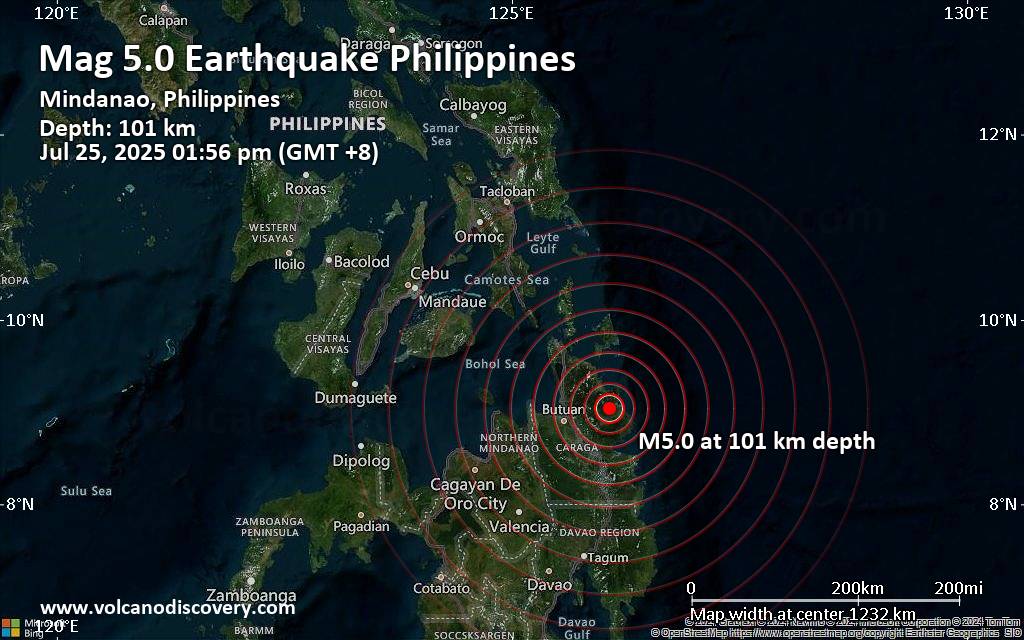 An earthquake of magnitude 5.0 occurred only 9 minutes ago 15 km southwest of Tandag, Philippines, Indonesia's Meteorology, Climatology, and Geophysical Agency reported.
The quake hit at an intermediate depth of 101. km beneath the epicenter near Tandag, Surigao del Sur, Caraga, Philippines, around noon on Friday, July 25th, 2025, at 1:56 pm local time. The exact magnitude, epicenter, and depth of the quake might be revised within the next few hours or minutes as seismologists review data and refine their calculations, or as other agencies issue their report.
Based on the preliminary seismic data, the quake should not have caused any significant damage, but was probably felt by many people as light vibration in the area of the epicenter.
Weak shaking might have been felt in Gamut (pop. 2,200) located 12 km from the epicenter, Tandag (pop. 29,000) 15 km away, Bayugan (pop. 40,600) 46 km away, Bah-Bah (pop. 28,600) 51 km away, Butuan (pop. 309,700) 59 km away, Cabadbaran (pop. 31,100) 59 km away, and Libertad (pop. 250,400) 63 km away.
Other towns or cities near the epicenter where the quake might have been felt as very weak shaking include Buenavista (pop. 68,900) located 73 km from the epicenter, and Bislig (pop. 67,600) 96 km away.
VolcanoDiscovery will automatically update magnitude and depth if these change and follow up if other significant news about the quake become available. If you’re in the area, please send us your experience through our reporting mechanism, either online or via our mobile app. This will help us provide more first-hand updates to anyone around the globe who wants to know more about this quake.
Earthquake data: Date & time: Jul 25, 2025 01:56 pm (GMT +8) local time (25 Jul 2025 05:56 GMT)Magnitude: 5.0 Depth: 101.00 km Epicenter latitude / longitude: 9.04°N / 126.07°E  ( Province of Surigao del Sur, Caraga, Philippines) Primary data source: BMKGhttps://www.volcanodiscovery.com/earthquake/news/276448/Moderate-yet-deep-magnitude-50-quake-hits-15-km-southwest-of-Tandag-Philippines-around-noon-.html
0
17
Read More
|
Magnitude 3.1 earthquake strikes near Preveza, Préveza, Epirus, Greece
Webmaster
9 hours ago
Magnitude 3.1 earthquake strikes near Preveza, Préveza, Epirus, Greece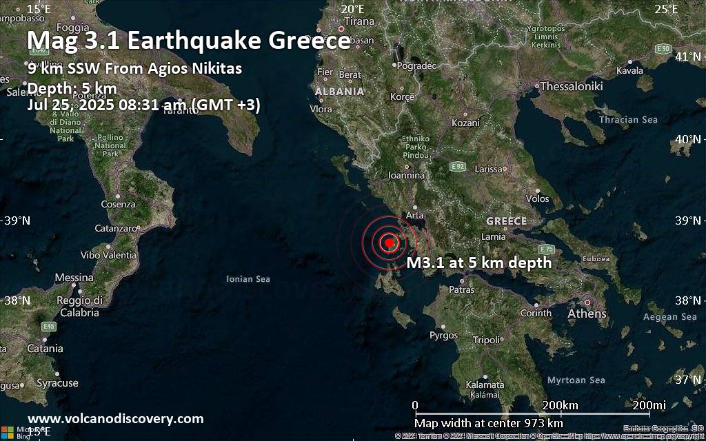 A very shallow magnitude 3.1 earthquake was reported in the morning near Preveza, Préveza, Epirus, Greece.
According to the National Observatory of Athens (NOA), the quake hit on Friday, July 25th, 2025, at 8:31 am local time at a very shallow depth of 5. km. Shallow earthquakes are felt more strongly than deeper ones as they are closer to the surface. The exact magnitude, epicenter, and depth of the quake might be revised within the next few hours or minutes as seismologists review data and refine their calculations, or as other agencies issue their report.
A second report was later issued by The Aristotle University of Thessaloniki Geophysical Lab. (AUTH), which listed it as a magnitude 2.9 earthquake. Other agencies reporting the same quake include The Seismological Laboratory of the University of Athens (UOA) at magnitude 3.0, and the citizen-seismograph network of RaspberryShake at magnitude 3.1.
Based on the preliminary seismic data, the quake should not have caused any significant damage, but was probably felt by many people as light vibration in the area of the epicenter.
Weak shaking might have been felt in Komilio (pop. 40) located 2 km from the epicenter.
Other towns or cities near the epicenter where the quake might have been felt as very weak shaking include Lefkada (pop. 8,700) located 17 km from the epicenter, Palairos (pop. 2,600) 28 km away, and Preveza (pop. 17,300) 31 km away. In Kandila (pop. 1,200, 33 km away), Vonitsa (pop. 4,700, 35 km away), Monastiraki (pop. 1,300, 36 km away), Ithaki (pop. 1,800, 41 km away), and Arta (pop. 21,900, 61 km away), the quake was probably not felt.
Earthquake data: Date & time: Jul 25, 2025 08:31 am (GMT +3) local time (25 Jul 2025 05:31 GMT)Magnitude: 3.1 Depth: 5.00 km Epicenter latitude / longitude: 38.72°N / 20.57°E  ( Lefkada, Ionian Islands, Greece) Primary data source: NOAhttps://www.volcanodiscovery.com/earthquake/news/276446/Magnitude-31-earthquake-strikes-near-Preveza-Preveza-Epirus-Greece.html
0
14
Read More
|
Moderate magnitude 4.6 earthquake 66 km southeast of Pondaguitan, Philippines
Webmaster
10 hours ago
Moderate magnitude 4.6 earthquake 66 km southeast of Pondaguitan, Philippines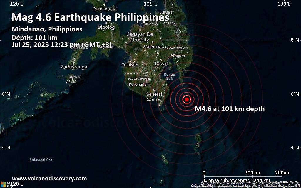 Just 6 minutes ago, a 4.6-magnitude earthquake struck near Pondaguitan, Davao Oriental, Davao, Philippines. The tremor was recorded around noon on Friday, July 25th, 2025, at 12:23 pm local time, at an intermediate depth of 101. km below the surface.
The event was filed by Indonesia's Meteorology, Climatology, and Geophysical Agency, the first seismological agency to report it.
Towns or cities near the epicenter where the quake might have been felt as very weak shaking include Pondaguitan (pop. 2,100) located 66 km from the epicenter, Caburan (pop. 12,600) 81 km away, Talagutong (pop. 8,000) 92 km away, Tibanbang (pop. 7,800) 97 km away, and Malita (pop. 41,100) 107 km away.
VolcanoDiscovery will automatically update magnitude and depth if these change and follow up if other significant news about the quake become available. If you’re in the area, please send us your experience through our reporting mechanism, either online or via our mobile app. This will help us provide more first-hand updates to anyone around the globe who wants to know more about this quake.
Earthquake data: Date & time: Jul 25, 2025 12:23 pm (GMT +8) local time (25 Jul 2025 04:23 GMT)Magnitude: 4.6 Depth: 101.00 km Epicenter latitude / longitude: 5.8°N / 126.36°E ( Sulawesi Utara, Philippines) Primary data source: BMKGhttps://www.volcanodiscovery.com/earthquake/news/276434/Moderate-magnitude-46-earthquake-66-km-southeast-of-Pondaguitan-Philippines.html
0
11
Read More
|
Seismic-like event, possible earthquake, reported few minutes ago near Carlsbad, New Mexico, USA
Webmaster
11 hours ago
Seismic-like event, possible earthquake, reported few minutes ago near Carlsbad, New Mexico, USA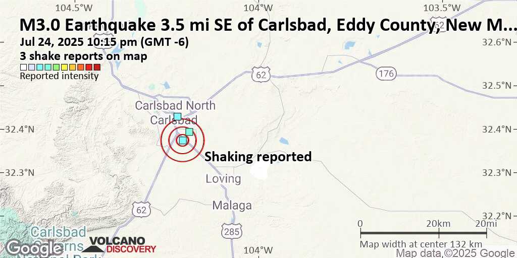 Unconfirmed quake or seismic-like event reported: 3.5 mi southeast of Carlsbad, Eddy County, New Mexico, United States, 3 minutes ago We are receiving unverified early reports of ground shaking possibly caused by seismic activity in or near Carlsbad, New Mexico, USA on 25 Jul 2025 (GMT) at approximately 04:15 GMT.
There are no details yet on the magnitude or depth of this possible quake. If confirmed, we can expect more accurate data to emerge in the next few minutes. The location, magnitude and time mentioned are indicative, based on our best-fit seismic model. They are temporary until our AllQuakes monitoring service receives more exact scientific data from a national or international seismological agency. Check back here shortly and stay safe.
Earthquake data: Date & time: Jul 24, 2025 10:15 pm (GMT -6) local time (25 Jul 2025 04:15 GMT)Magnitude: unspecified Depth: unspecified Epicenter latitude / longitude: 32.37°N / 104.21°W  ( New Mexico, United States) Primary data source: VolcanoDiscoveryhttps://www.volcanodiscovery.com/earthquake/news/276432/Seismic-like-event-possible-earthquake-reported-few-minutes-ago-near-Carlsbad-New-Mexico-USA.html
0
12
Read More
|
Significant 5.1 quake hits near Bengkulu, Kota Bengkulu, Indonesia
Webmaster
11 hours ago
Significant 5.1 quake hits near Bengkulu, Kota Bengkulu, Indonesia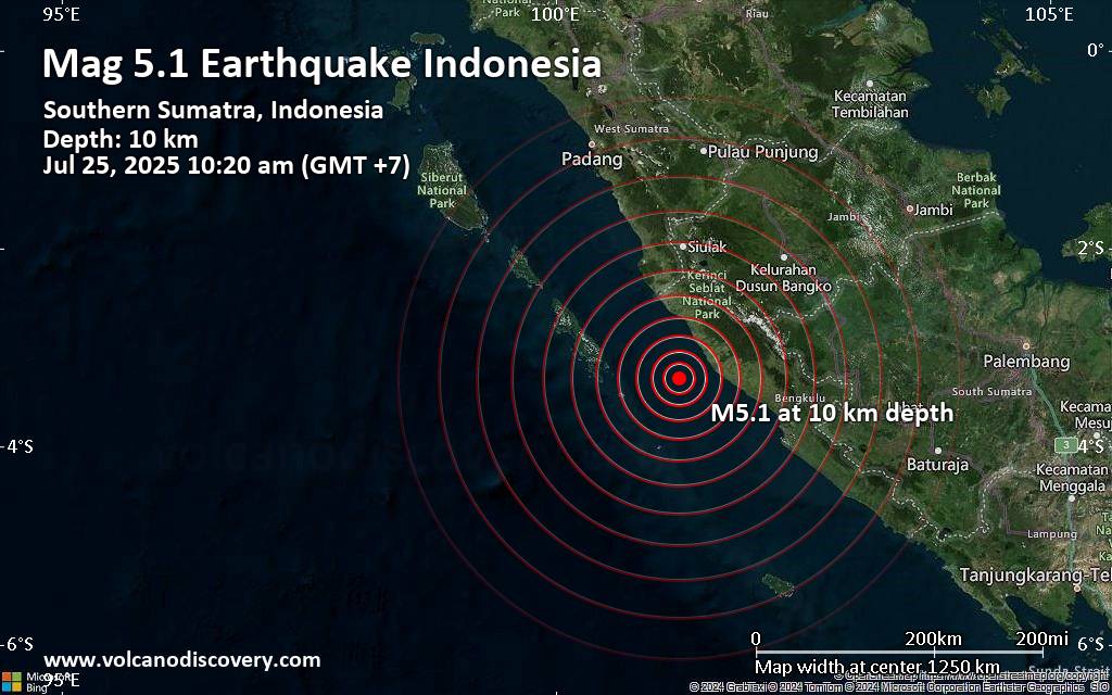 A magnitude 5.1 earthquake near Bengkulu, Kota Bengkulu, Indonesia, was reported only 7 minutes ago by Indonesia's Meteorology, Climatology, and Geophysical Agency, considered the main national agency that monitors seismic activity in Indonesia. The earthquake occurred at a shallow depth of 10. km beneath the epicenter in the morning on Friday, July 25th, 2025, at 10:20 am local time. The exact magnitude, epicenter, and depth of the quake might be revised within the next few hours or minutes as seismologists review data and refine their calculations, or as other agencies issue their report.
Based on the preliminary seismic data, the quake should not have caused any significant damage, but was probably felt by many people as light vibration in the area of the epicenter.
Weak shaking might have been felt in Bengkulu (pop. 373,600) located 125 km from the epicenter.
VolcanoDiscovery will automatically update magnitude and depth if these change and follow up if other significant news about the quake become available. If you’re in the area, please send us your experience through our reporting mechanism, either online or via our mobile app. This will help us provide more first-hand updates to anyone around the globe who wants to know more about this quake.
Earthquake data: Date & time: Jul 25, 2025 10:20 am (GMT +7) local time (25 Jul 2025 03:20 GMT)Magnitude: 5.1 Depth: 10.00 km Epicenter latitude / longitude: 3.33°S / 101.24°E  ( Bengkulu, Indonesia) Primary data source: BMKGhttps://www.volcanodiscovery.com/earthquake/news/276430/Significant-51-quake-hits-near-Bengkulu-Kota-Bengkulu-Indonesia.html
0
10
Read More
|
Seismic-like event, possible earthquake, reported few minutes ago near Nagasaki, Nagasaki, Japan
Webmaster
13 hours ago
Seismic-like event, possible earthquake, reported few minutes ago near Nagasaki, Nagasaki, Japan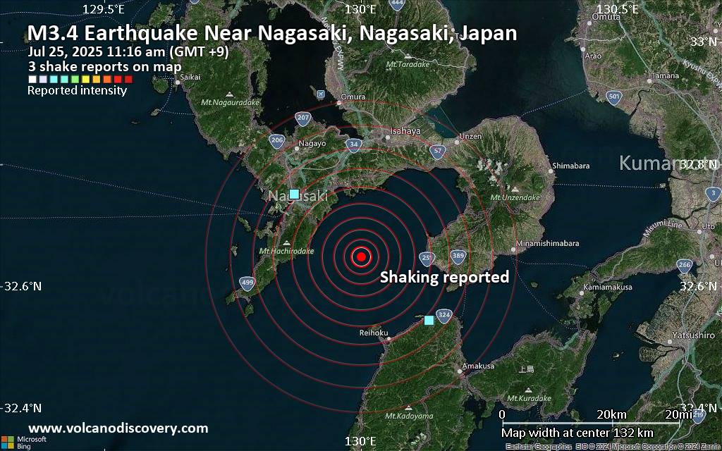 Unconfirmed quake or seismic-like event reported: Near Nagasaki, Nagasaki, Japan, 6 minutes ago We are receiving unverified early reports of ground shaking possibly caused by seismic activity in or near Nagasaki, Nagasaki, Japan on 25 Jul 2025 (GMT) at approximately 02:16 GMT.
There are no details yet on the magnitude or depth of this possible quake. If confirmed, we can expect more accurate data to emerge in the next few minutes. The location, magnitude and time mentioned are indicative, based on our best-fit seismic model. They are temporary until our AllQuakes monitoring service receives more exact scientific data from a national or international seismological agency. Check back here shortly and stay safe.
Earthquake data: Date & time: Jul 25, 2025 11:16 am (GMT +9) local time (25 Jul 2025 02:16 GMT)Magnitude: unspecified Depth: unspecified Epicenter latitude / longitude: 32.65°N / 130°E  ( Nagasaki, Japan) Primary data source: VolcanoDiscoveryhttps://www.volcanodiscovery.com/earthquake/news/276426/Seismic-like-event-possible-earthquake-reported-few-minutes-ago-near-Nagasaki-Nagasaki-Japan.html
0
10
Read More
|
|
Forums60
Topics732,201
Posts766,824
Members2,958
| |
Most Online4,158
Jun 21st, 2024
|
|
|
|
|
Copyright 1996 - 2024 by David Cottle. Designed by David Bate Jr. All Rights Reserved.
By using this forum, the user agrees not to transfer any data or technical information received under the agreement, to any other entity without the express approval of the AUS-CITY Forum Admins and/or authors of individual posts (Forum Admins and DoD/USSPACECOM for the analysis of satellite tracking data).
Two-line elements (TLE) and all other satellite data presented and distributed via this forum and e-mail lists of AUS-CITY are distributed with permission from DoD/USSTRATCOM.


Reprise Hosting

|

|


 - Click image for larger picture.")


