|
0 members (),
972
guests, and
30
robots. |
|
Key:
Admin,
Global Mod,
Mod
|
|
S |
M |
T |
W |
T |
F |
S |
|
|
|
1
|
2
|
3
|
4
|
5
|
|
6
|
7
|
8
|
9
|
10
|
11
|
12
|
|
13
|
14
|
15
|
16
|
17
|
18
|
19
|
|
20
|
21
|
22
|
23
|
24
|
25
|
26
|
|
27
|
28
|
29
|
30
|
|
|
|
|
There are no members with birthdays on this day. |
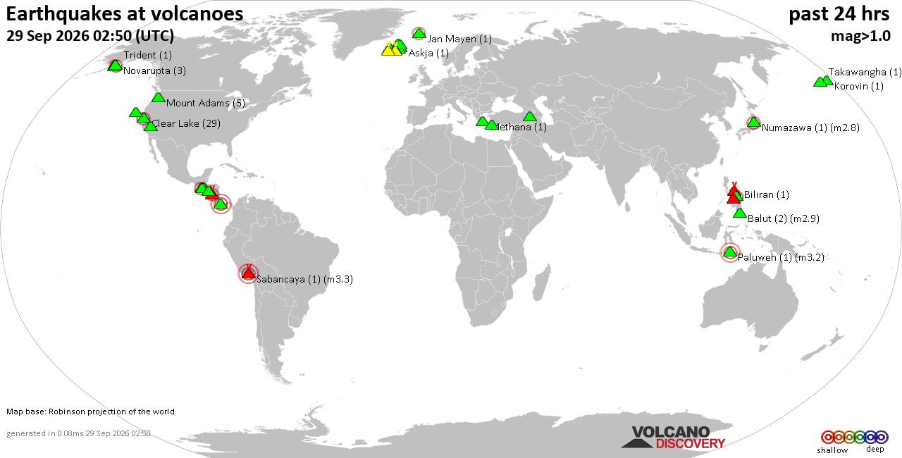
Volcano earthquake report for Tuesday, 29 September 2026
• M 0.6 - 67 km ENE of Pedro Bay, Alaska
• M 1.8 - 25 km SSW of Nanwalek, Alaska
• M 1.5 - 6 km NW of Pinnacles, CA
• M 2.0 - 58 km NE of King Cove, Alaska
• M -1.1 - 77 km NW of Ninilchik, Alaska
|

#835330
Wed 19 Aug 2026 09:55:PM
|
Joined: Feb 2001
Posts: 678,977
Launch Director
|
|
Launch Director
Joined: Feb 2001
Posts: 678,977 |
SPC Day 3-8 Fire Weather OutlookSPC Day 3-8 Fire Weather Outlook 
Day 3-8 Fire Weather Outlook
NWS Storm Prediction Center Norman OK
0450 PM CDT Wed Aug 19 2026

Valid 211200Z - 271200Z

...Synopsis...
An established ridge over the Intermountain West will amplify and
the pressure gradient will continue to tighten on Day 3/Friday as a
trough approaches the west CONUS coast. A mid-level low pressure
system will near the Pacific Northwest coast on Day 3/Friday as the
upper-level jet max peaks over southern/central OR. This will
provide widespread lift to portions of the Cascade Mountains and
then much of central/eastern WA under the left exit region of the
jet streak on the evening/night of Day 3/Friday. The trough will
begin to lift northeastward as it becomes slightly negatively-tilted
going into Day 4/Saturday. High pressure remains in place over much
of the southwestern half of the CONUS with shortwave trough passages
periodically moving across the crest of the high through the
northern states. While slight differences in timing of the
aforementioned trough remain, the overall pattern evolution remains
similar amongst various ensemble forecast guidance. As we turn the
corner toward next week, the ridge broadens and builds over the
Intermountain West once again. Forecast certainty in any particular
solution decreases thereafter given greater ensemble spread.

...Pacific Northwest/Northern California/Great Basin...
The Pacific Northwest and immediately neighboring areas of northern
California and the Great Basin will remain the foci through at least
the first half of the extended forecast. Starting on Day 3/Friday
and continuing through Day 4/Saturday, expect multiple consecutive
days of gusty southwesterly winds combined with warm and dry weather
as the aforementioned large trough approaches from the west.
Increasing above-normal temperatures through Day 3/Friday will give
way to cooler conditions as the trough approaches and moves onshore
Day 4/Saturday. Given the jet aloft and surface conditions that
would support deep daytime mixing, a favorable pattern remains in
place for dry and breezy weather to overlap very dry fuels across
northeastern CA, southern OR, and northwestern NV. 40% Critical
probabilities were maintained on Day 3/Friday through Day 4/Saturday
along with a widespread 10% probability of Dry Thunderstorms over
much of the Pacific Northwest and the nearby northern Rockies.
Additionally, where winds appear strongest (sustained at 20-25 mph
from the southwest) over the tri-state CA, OR, NV area, 70% Critical
probabilities were maintained on Day 4/Saturday. While a
thunderstorm or two favoring the higher terrain of the Cascades (and
pyro-aided convection amid initially hot, dry, and windy surface
conditions) can't be ruled out on the afternoon of Day 3/Friday, the
best convective potential will occur starting around 06Z on Saturday
(Friday night) as the jet max approaches. This pattern of
aforementioned upper-level support, limited but adequate
(precipitable water values near 0.5-0.7") moisture, fast-moving
(25-35 mph) storms, and dry fuels (ERCs near the 80-95th percentile)
remains in place on Day 4/Saturday. With minimal precipitation
expected from the previous day, an area of 10% Dry Thunderstorm risk
was introduced over portions of the northern Pacific Northwest
region and the nearby far western extent of the northern Rockies
region.

...Southern Plains...
On Day 5/Sunday and Day 6/Monday, a cold front will move across the
southern Plains, increasing fire weather risk in southwesterly flow
ahead of the front as it progresses southeastward. Current ensemble
forecast guidance suggests sustained 10-20 mph south to
southwesterly winds will combine with afternoon RHs near 15-20%
across the TX/OK Panhandles and surrounding areas with critically
dry fuels.

...Northern Plains...
Evolution of the post-frontal northwesterly winds over the northern
High Plains remains a concern on Day 5/Sunday. Across much of the
central MT, sustained northwesterly winds of 10-20 mph will occur.
Some forecast guidance shows these strong and gusty winds extending
even farther across eastern MT. This area will be watched closely
with future outlook issuances.

..Stearns.. 08/19/2026

...Please see www.spc.noaa.gov/fire for graphic product...
Read morehttps://www.spc.noaa.gov/products/exper/fire_wx/
|
|



CMS The Best Conveyancing solicitors conveyancing quotes throughout the UK
For any webhosting enquiries please email webmaster@aus-city.com
|
|
Forums60
Topics846,460
Posts881,255
Members2,960
| |
Most Online102,106
Jul 10th, 2026
|
|
|









































