|
0 members (),
1,279
guests, and
21
robots. |
|
Key:
Admin,
Global Mod,
Mod
|
|
S |
M |
T |
W |
T |
F |
S |
|
|
1
|
2
|
3
|
4
|
5
|
6
|
|
7
|
8
|
9
|
10
|
11
|
12
|
13
|
|
14
|
15
|
16
|
17
|
18
|
19
|
20
|
|
21
|
22
|
23
|
24
|
25
|
26
|
27
|
|
28
|
29
|
30
|
|
|
|
|
|
There are no members with birthdays on this day. |

Volcano earthquake report for Friday, 26 Jun 2026
• Moderate mag. 4.7 earthquake - Indonesia: Northern Molucca Sea on Friday, J...
• World Earthquake Report for Friday, 26 June 2026
• Significant 5.0 quake hits near La Romana, Provincia de La Romana, Dominica...
• No Tsunami Threat After Magnitude 5.0 Earthquake Near Isla Mona
• Moderate mag. 4.9 earthquake - Caribbean Sea, Provincia de San Cristobal, 3...
|
 SPC MD 1330
Webmaster
32 minutes ago
SPC MD 1330
Webmaster
32 minutes ago
SPC MD 1330MD 1330 CONCERNING SEVERE POTENTIAL...WATCH UNLIKELY FOR EASTERN KENTUCKY INTO WESTERN PARTS OF WEST VIRGINIA AND VIRGINIA 
Mesoscale Discussion 1330
NWS Storm Prediction Center Norman OK
1259 PM CDT Fri Jun 26 2026

Areas affected...eastern Kentucky into western parts of West
Virginia and Virginia

Concerning...Severe potential...Watch unlikely

Valid 261759Z - 262000Z

Probability of Watch Issuance...20 percent

SUMMARY...The potential for a few damaging wind gusts is expected to
increase this evening. Limited areal coverage and magnitude of
threat are expected to preclude a watch issuance.

DISCUSSION...Ahead of a well-defined MCV, a line of showers and
thunderstorms has recently intensified in the vicinity of I-75, near
Richmond. Daytime heating within the downstream air mass is
contributing to destabilization with steep low-level lapse rates and
MLCAPE of around 1000 J/kg evident in latest objective analysis. As
such, expect the ongoing storms to further intensify while moving
through eastern KY, potentially into western parts of WV and VA this
afternoon. While relatively weak wind fields and resultant vertical
shear are expected to limit the potential for an organized cold pool
to evolve, locally damaging downburst winds appear possible given
the presence of the steep low-level lapse rates.

The anticipated areal coverage and magnitude of the damaging wind
threat are currently expected to remain too marginal for a watch
issuance.

..Mead/Guyer.. 06/26/2026

...Please see www.spc.noaa.gov for graphic product...

ATTN...WFO...RNK...RLX...MRX...JKL...LMK...

LAT...LON   37098463 37878421 38268324 38578205 38488130 37938109
            37398153 37078184 36698270 36678408 37098463

MOST PROBABLE PEAK WIND GUST...UP TO 60 MPH
Read morehttps://www.spc.noaa.gov/products/md/md1330.html
0
3
Read More
|
SPC MD 1331
Webmaster
32 minutes ago
SPC MD 1331MD 1331 CONCERNING SEVERE POTENTIAL...WATCH POSSIBLE FOR SOUTHEAST KANSAS...NORTHEAST OKLAHOMA...AND SOUTHWEST MISSOURI 
Mesoscale Discussion 1331
NWS Storm Prediction Center Norman OK
0138 PM CDT Fri Jun 26 2026

Areas affected...southeast Kansas...northeast Oklahoma...and
southwest Missouri

Concerning...Severe potential...Watch possible

Valid 261838Z - 262045Z

Probability of Watch Issuance...60 percent

SUMMARY...Severe weather potential is expected to increase across
the area this afternoon. Large hail up to 1.5-1.75" and severe wind
gusts of 60-65 mph appear to be the primary hazards. Convective
trends are being monitored for a Severe Thunderstorm Watch.

DISCUSSION...Recent trends in visible satellite indicate deepening
cumulus along an outflow boundary from near the Arkansas City to
Independence, KS vicinities into southwest MO, north of Joplin. The
air mass to the south of the boundary has warmed into the 80s,
which, coupled with dewpoints in the low to mid 70s is resulting in
MLCAPE of 1500-2500+ J/kg, per latest objective analysis.
Large-scale forcing for ascent remains somewhat nebulous with the
movement of several MCVs to the east of the region and no apparent
upstream disturbances in water vapor imagery. Nonetheless, the
presence of modest low-level warm advection observed by the KSGF VWP
may be sufficient to support eventual storm development in the
vicinity of the outflow boundary.

Area VWPs and forecast soundings suggest deep-layer shear will be on
the margins of that supportive of supercell storm modes. That,
coupled with only modestly steep mid-level lapse rates, should limit
hail size to 1.5-1.75". Damaging wind potential may ultimately be of
greater concern owing to the very moist environment and potential
for water-loaded downdrafts. A brief tornado is possible given
sizable 0-3 km CAPE and ambient vorticity in the vicinity of the
boundary. Otherwise, generally modest low-level shear should limit
the overall tornado potential.

Convective trends are being monitored for the potential issuance of
a Severe Thunderstorm Watch.

..Mead/Guyer.. 06/26/2026

...Please see www.spc.noaa.gov for graphic product...

ATTN...WFO...SGF...EAX...TSA...ICT...

LAT...LON   37609617 37949483 38119345 37889279 37269258 36779311
            36619422 36709550 36839620 36919655 37159666 37609617

MOST PROBABLE PEAK TORNADO INTENSITY...UP TO 90 MPH
MOST PROBABLE PEAK WIND GUST...55-70 MPH
MOST PROBABLE PEAK HAIL SIZE...1.00-1.75 IN
Read morehttps://www.spc.noaa.gov/products/md/md1331.html
0
2
Read More
|
SPC MD 1332
Webmaster
32 minutes ago
SPC MD 1332MD 1332 CONCERNING SEVERE POTENTIAL...WATCH UNLIKELY FOR PORTIONS OF THE COASTAL CAROLINAS 
Mesoscale Discussion 1332
NWS Storm Prediction Center Norman OK
0158 PM CDT Fri Jun 26 2026

Areas affected...portions of the coastal Carolinas

Concerning...Severe potential...Watch unlikely

Valid 261858Z - 262130Z

Probability of Watch Issuance...20 percent

SUMMARY...A damaging gust or two is possible this afternoon across
portions of the coastal Carolinas. A watch is not anticipated.

DISCUSSION...A seasonably moist air mass is in place across portions
of the eastern Carolinas, where convective temperatures have been
reached, resulting in scattered thunderstorms ongoing this
afternoon. The KLTX VWP shows generally weak flow, which correlates
with the single- and multicell modes apparent on radar. Due to the
high precipitable water values (>2 in) in place across the region,
water loading in downdrafts may be enough for some damaging gusts
across the region. Additionally, storms may cluster with time, and
this may slightly increase the threat for damaging gusts. However,
this threat is still expected to be fairly sporadic, and therefore a
watch is not expected at this time.

..Supinie/Guyer.. 06/26/2026

...Please see www.spc.noaa.gov for graphic product...

ATTN...WFO...MHX...RAH...ILM...CHS...CAE...

LAT...LON   34318072 35637883 35877771 35687717 35077709 34207802
            33227910 33058014 33088070 33348119 33948112 34318072

MOST PROBABLE PEAK WIND GUST...UP TO 60 MPH
Read morehttps://www.spc.noaa.gov/products/md/md1332.html
0
3
Read More
|
SPC MD 1333
Webmaster
32 minutes ago
SPC MD 1333MD 1333 CONCERNING SEVERE POTENTIAL...WATCH UNLIKELY FOR CENTRAL VIRGINIA INTO THE DELMARVA 
Mesoscale Discussion 1333
NWS Storm Prediction Center Norman OK
0237 PM CDT Fri Jun 26 2026

Areas affected...central Virginia into the Delmarva

Concerning...Severe potential...Watch unlikely

Valid 261937Z - 262130Z

Probability of Watch Issuance...20 percent

SUMMARY...The potential for locally damaging wind gusts is expected
to increase across the discussion area this afternoon into early
evening. The areal coverage and magnitude of the threat are expected
to remain too limited for a watch consideration.

DISCUSSION...Recent radar trends indicate gradually strengthening
storms along the Blue Ridge Mountains in northern VA with additional
storms noted in southeast WV. East of the high terrain, a relatively
warm and moist air mass is present with steep low-level lapse rates
and MLCAPE of around 1000 J/kg indicated in latest objective
analyses. The presence of a westerly, deep-layer wind field should
support the eastward movement of storms across the discussion area
with the absence of appreciable forcing for ascent potentially
limiting overall storm coverage.

The KRLX and KLWX VWPs indicate 30-35 kt winds above 5 km, which are
boosting vertical shear generally along and north of that latitude.
That modest shear enhancement may contribute to some briefly
organized storms capable of locally damaging wind gusts. Relatively
warm mid-level temperatures and resultant poor lapse rates should
limit large hail potential.

Given the expected isolated nature of the threat, a watch is not
anticipated.

..Mead/Guyer.. 06/26/2026

...Please see www.spc.noaa.gov for graphic product...

ATTN...WFO...PHI...AKQ...LWX...RNK...

LAT...LON   37917993 38317971 38907858 39347734 39357633 39097564
            38577537 37957594 37637758 37397828 37357879 37407922
            37537966 37917993

MOST PROBABLE PEAK WIND GUST...UP TO 60 MPH
Read morehttps://www.spc.noaa.gov/products/md/md1333.html
0
2
Read More
|
SPC Severe Thunderstorm Watch 397 Status Reports
Webmaster
33 minutes ago
SPC Severe Thunderstorm Watch 397 Status ReportsWW 0397 Status Updates 
STATUS REPORT ON WW 397

THE SEVERE WEATHER THREAT CONTINUES ACROSS THE ENTIRE WATCH AREA.

..MEAD..06/26/26

ATTN...WFO...GYX...BTV...


STATUS REPORT FOR WS 397

SEVERE WEATHER THREAT CONTINUES FOR THE FOLLOWING AREAS

MEC031-262040-

ME
.    MAINE COUNTIES INCLUDED ARE

YORK


NHC001-003-005-009-011-013-015-017-019-262040-

NH
.    NEW HAMPSHIRE COUNTIES INCLUDED ARE

BELKNAP              CARROLL             CHESHIRE
GRAFTON              HILLSBOROUGH        MERRIMACK
ROCKINGHAM           STRAFFORD           SULLIVAN


VTC001-017-021-027-262040-

VT
.    VERMONT COUNTIES INCLUDED ARE

ADDISON              ORANGE              RUTLAND
WINDSOR
Read morehttps://www.spc.noaa.gov/products/watch/ws0397.html
0
3
Read More
|
SPC Severe Thunderstorm Watch 397
Webmaster
33 minutes ago
SPC Severe Thunderstorm Watch 397WW 397 SEVERE TSTM ME NH VT 261815Z - 270100Z
URGENT - IMMEDIATE BROADCAST REQUESTED
Severe Thunderstorm Watch Number 397
NWS Storm Prediction Center Norman OK
215 PM EDT Fri Jun 26 2026

The NWS Storm Prediction Center has issued a

* Severe Thunderstorm Watch for portions of
  Southwest Maine
  New Hampshire
  Vermont

* Effective this Friday afternoon and evening from 215 PM until
  900 PM EDT.

* Primary threats include...
  Scattered damaging wind gusts to 65 mph possible
  Isolated large hail events to 1.5 inches in diameter possible
  A tornado or two possible

SUMMARY...Storms should intensify initially over Vermont, with
additional development and movement east-southeastward into New
Hampshire and southwest Maine through late afternoon and early
evening, with hail and damaging winds as the primary hazards.

The severe thunderstorm watch area is approximately along and 45
statute miles north and south of a line from 25 miles northwest of
Rutland VT to 15 miles north northeast of Portsmouth NH. For a
complete depiction of the watch see the associated watch outline
update (WOUS64 KWNS WOU7).

PRECAUTIONARY/PREPAREDNESS ACTIONS...

REMEMBER...A Severe Thunderstorm Watch means conditions are
favorable for severe thunderstorms in and close to the watch area.
Persons in these areas should be on the lookout for threatening
weather conditions and listen for later statements and possible
warnings. Severe thunderstorms can and occasionally do produce
tornadoes.

&&

AVIATION...A few severe thunderstorms with hail surface and aloft to
1.5 inches. Extreme turbulence and surface wind gusts to 55 knots. A
few cumulonimbi with maximum tops to 500. Mean storm motion vector
29025.

...Guyer
Read morehttps://www.spc.noaa.gov/products/watch/ww0397.html
0
3
Read More
|
SPC Day 2 Fire Weather Outlook
Webmaster
41 minutes ago
SPC Day 2 Fire Weather OutlookSPC Day 2 Fire Weather Outlook 
Day 2 Fire Weather Outlook
NWS Storm Prediction Center Norman OK
0230 PM CDT Fri Jun 26 2026

Valid 271200Z - 281200Z

...EXTREMELY CRITICAL FIRE WEATHER AREA FOR PORTIONS OF WESTERN
COLORADO AND EASTERN UTAH INTO THE FOUR CORNERS REGION...
...CRITICAL FIRE WEATHER AREA FOR MUCH OF NEVADA...NORTHERN
ARIZONA...NORTHWESTERN NEW MEXICO...CENTRAL/SOUTHERN UTAH...SOUTHERN
WYOMING...AND WESTERN COLORADO...

***Dangerous fire weather conditions are expected on Day 2/Saturday
across the Four Corners into portions of the Colorado Plateau***

...Afternoon Update...
An Extremely Critical risk area was introduced where guidance
depicts an overlap of sustained 25-35 mph southwesterly winds and
less than 10% RH on Day 2/Saturday. Despite some recent rainfall
across the West Slope, appreciable precipitation was not common, and
rather quite localized. Widespread 80-95th percentile ERCs and
recently receptive fuels will be conducive to rapid spread/fire
growth on existing wildfires and any new ignitions. Furthermore,
isolated dry thunderstorms on Day 1/Friday present additional
concerns for potential lightning holdovers to emerge as several days
of hot, dry and windy conditions ensue. An extended burning period
is expected (10+ hours for some locations) with poor overnight
humidity recoveries and residual gusty winds leading into another
day of critical fire weather conditions (see the Day 3-8 Fire
Weather Outlook).

The rest of the forecast remains on track, see the previous
discussion for more information.

..Elizalde-Garcia.. 06/26/2026

.PREV DISCUSSION... /ISSUED 0302 AM CDT Fri Jun 26 2026/

...Synopsis...
A seasonably strong mid-level trough will continue to dig into the
western CONUS on D2/Saturday, with an attendant mid-level jet
overspreading much of the Upper Colorado River Basin. This will
continue to support a robust fire weather pattern across an
expansive portion of the Great Basin and Southwest through the
weekend.

...Great Basin/Southwest...
As the mid-level jet associated with the digging mid-level trough
shifts eastward into the Upper Colorado River Valley, a corridor of
stronger, sustained surface winds (25-30 mph) will expand from
southeastern Nevada into the Colorado Plateau and overlap with very
low RH values of 10-15%. Exacerbated by dry, windy conditions on
D1/Friday, fuels will be very receptive, with ERCs already noted in
the 80-90+ percentiles. These conditions will promote an extended
period of critical fire weather conditions from southeastern Nevada
into the Upper Colorado River Basin and southern Wyoming. Localized
extremely critical wind/RH conditions are possible, particularly
across southeastern Utah and perhaps into southwestern Colorado
where latest high-res guidance suggests that the best overlap of
sustained southwesterly winds approaching 30 mph and very low RH
near 10% may occur. Pockets of fuels in this region are also noted
to be at or above the 95th percentile. A broader area of elevated
wind/RH conditions are expected across adjacent areas of the Great
Basin/Southwest where sustained winds of 15-25 mph are forecast to
overlap dry fuels and RH values of 10-20%.

The primary change with this outlook was to expand the Critical
highlights into north central Colorado based on the latest high-res
guidance. Consideration was given to the addition of a targeted
Extremely Critical area; however, some uncertainty remains regarding
the duration of overlap between sustained winds exceeding 30 mph and
RH values dropping below 10%. A portion of the Elevated highlights
were also trimmed across central Wyoming and the foothills of
northern Colorado owing to recent rainfall.

...Please see www.spc.noaa.gov/fire for graphic product...
Read morehttps://www.spc.noaa.gov/products/fire_wx/fwdy2.html
0
2
Read More
|
SPC Jun 26, 2026 1930 UTC Day 3 Severe Thunderstorm Outlook
Webmaster
56 minutes ago
SPC Jun 26, 2026 1930 UTC Day 3 Severe Thunderstorm OutlookSPC 1930Z Day 3 Outlook 
Day 3 Convective Outlook
NWS Storm Prediction Center Norman OK
0216 PM CDT Fri Jun 26 2026

Valid 281200Z - 291200Z

...THERE IS A SLIGHT RISK OF SEVERE THUNDERSTORMS ACROSS PORTIONS OF
NORTH DAKOTA AND THE UPPER MIDWEST...

...SUMMARY...
Severe thunderstorms are possible from the northern Plains into
parts of the Upper Midwest on Sunday. Large hail and severe winds
are the primary hazards.

...Synopsis...

The western U.S. upper trough will deepen and persist over that
region on Sunday. Meanwhile, upper ridging will intensify over the
Midwest into the South, while a shortwave upper trough moves from
the Ohio Valley to the southern Mid-Atlantic region. At the surface,
some uncertainty persists with regards to the location of lee
surface low development in the central or northern Plains. The NAM
appears to be an outlier compared to the ECMWF/GFS and the AI
versions thereof. This will be important for where the best corridor
of severe thunderstorm potential develops on Sunday
afternoon/evening. Further east, a surface front will sag southward
across the Upper OH Valley and portions of the Mid-Atlantic. Between
these surface boundaries, a seasonally very moist airmass will exist
across at least eastern portions of the Plains to the MS Valley and
the southern Mid-Atlantic.

...Northern Plains/Upper Midwest vicinity...

The forecast for Sunday is highly uncertain. Forecast guidance
suggests a shortwave impulse and/or MCV will move across northern MN
during the afternoon/evening. This area will be beneath the upper
ridge axis and could be capped. However, a very moist airmass will
be in place beneath steep midlevel lapse rates. Furthermore, a
strong southerly low-level jet is expected to focus from the central
Plains to the Upper MS Valley during the evening/nighttime hours. If
storms can develop and become near-surface based, potential for
damaging wind gusts and large hail will be possible. This scenario
is generally supported by the RRFS and GSL MPAS, though
location/timing varies.

Forecast guidance develops additional areas of convection across
portions of western NE/central SD into ND on the western periphery
of stronger capping and near the surface trough/dryline within the
gradient of stronger instability. This scenario is uncertain, both
regarding storm development, and if storms occur, whether or not
they will be surface-based. However, if storms do develop, an
intense low-level jet within the strongly unstable airmass during
the evening/overnight hours could support damaging wind potential.
The Marginal risk (level 1 of 5) has been adjusted to reflect this
conditional risk.

...Southern Mid-Atlantic...

Forecast guidance suggests an MCV will move across the central
Appalachians into parts of VA/NC on Sunday. Deep-layer flow is not
expected to be particularly strong, but this feature could locally
enhanced vertical shear, with some guidance showing effective shear
magnitudes up to 25 kt are possible. A seasonally very moist airmass
will reside east of the higher terrain across southeast VA into the
eastern Carolinas, supporting moderate destabilization as strong
daytime heating occurs. Thunderstorms will pose an isolated damaging
wind risk into early evening.

..Leitman.. 06/26/2026
Read morehttps://www.spc.noaa.gov/products/outlook/day3otlk_1930.html
0
3
Read More
|
SPC Jun 26, 2026 1730 UTC Day 2 Convective Outlook
Webmaster
2 hours ago
SPC Jun 26, 2026 1730 UTC Day 2 Convective OutlookSPC 1730Z Day 2 Outlook 
Day 2 Convective Outlook
NWS Storm Prediction Center Norman OK
1242 PM CDT Fri Jun 26 2026

Valid 271200Z - 281200Z

...THERE IS AN ENHANCED RISK OF SEVERE THUNDERSTORMS ACROSS PORTIONS
OF THE NORTHERN HIGH PLAINS...

...THERE IS A SLIGHT RISK OF SEVERE THUNDERSTORMS ACROSS SOUTHEAST
VA AND EASTERN NC...

...SUMMARY...
Severe storms are likely across portions of eastern Montana and
western/central North Dakota on Saturday. Severe storms will also be
possible from the Mid-Mississippi Valley to Virginia and the
Carolinas, as well as portions of the southern High Plains.

...Synopsis...

An upper low and attendant large-scale upper trough will persist
across the western U.S. on Saturday. Further east, upper ridging
over the Plains is forecast to shift east toward the Upper Midwest
and Mid-MS Valley by Sunday morning. Quasi-zonal/weak upper
troughing is expected to persist across the eastern U.S. Within this
large-scale regime, several shortwave impulses and embedded MCVs are
expected to drive severe thunderstorm potential across multiple
areas on Saturday. A lead upper shortwave trough is expected to
eject from the eastern Great Basin through the northern High Plains.
A series of MCVs will move from the Ozark Plateau to the OH/TN
Valleys, while another MCV and/or surface trough impacts
thunderstorm potential across the Mid-Atlantic/Piedmont. Finally,
another upper shortwave impulse could emerge across the central
Plains into the Mid-MO/Mid-MS Valleys.

...Northern Rockies into the Northern Plains...

A midlevel jet streak will overspread parts of the Great Basin into
the northern Plains, characterized by 50-60 kt southwesterly 500 mb
flow. Cooling aloft is also forecast and will result in a plume of
steep midlevel lapse rates. Surface low pressure is forecast to
deepen across northeast WY/western SD through evening. This will
support northward transport of low to mid 60s F dewpoints into
eastern MT/ND/SD. This will result in a narrow corridor of moderate
to strong instability. Capping will increase with eastward extent as
a result of midlevel height rises/warming aloft, which should
confine the eastward extent of severe potential.

As large-scale ascent increasing during the afternoon, convection is
expected to develop across the higher terrain of northern UT/ID into
WY. This initial activity will pose a risk for strong wind gusts and
isolated hail given strong deep-layer flow, steep midlevel lapse
rates, and a well mixed boundary layer. Additional convection is
expected to develop near the Big Horns and Beartooth/Absaroka
ranges. As this activity develops northeast into better low-level
moisture and strong instability, large to very large hail potential
will increase. With time during the evening, a southerly low-level
jet will increase across the Dakotas. Upscale growth is possible as
convection moves toward the terminus of the low-level jet and as
sufficient clustering/cold pool development occurs. If this
convective evolution unfolds, a swath of damaging wind gusts will be
possible, mainly across eastern MT into western ND.

...Mid-Atlantic...

Ongoing convection and cloudiness will likely hinder daytime
destabilization. Nevertheless, several shortwave impulses will move
across the region along with 25-30 kt westerly midlevel flow.
Isolated strong storms may produce gusty winds. The Slight risk
(level 2 of 5) has been confined to areas nearer the coast where
instability will be greatest.

...Southern High Plains...

A surface trough/dryline will extend south/southwest from western KS
to southwest TX. A moist airmass will exist east of this boundary
with hot temperatures forecast along and just behind the boundary.
Moderate to strong destabilization will occur near the boundary in a
narrow corridor, confined by stronger capping to the east across
much of OK/KS/central TX. However, isolated to widely scattered
storms are expected to develop during peak heating to early evening.
Vertically veering wind profiles with up to 25 kt effective shear
magnitudes suggest organized updrafts and high-based transient
supercell structures are possible. Given a deeply mixed boundary
layer, strong gusts will be possible. Organized updrafts that can be
maintained also will pose a risk of large hail given very steep
midlevel lapse rates and somewhat elongated hodographs.

...Ozarks to TN Valley vicinity...

Storms are forecast to be ongoing Saturday morning across southwest
MO. This activity could pose a marginal wind/hail risk initially.
Additional development is expected from southern IL/southeast MO
into KY/TN by late morning and spread east through the afternoon as
an MCV moves across the region. While deep layer flow will not be
impressive, the MCV could locally enhanced vertical shear.
Thunderstorm clusters will mainly pose a risk for damaging winds as
they track across moisture-rich and moderately unstable airmass.

...Northeast CO/Western NE into central SD...

Convection may develop during the late afternoon along the surface
trough/dryline. Rich boundary layer moisture beneath steep lapse
rates will support strong destabilization. This corridor will remain
rather confined given rising midlevel heights and capping to the
east. Any storms that develop will have potential for strong outflow
gusts and large hail.

...Mid-MO Valley vicinity...

It is uncertain if convection will develop across this area, or if
it does - will it be surface-based, resulting in a rather
conditional severe risk. If storms can develop, an all-hazards
severe risk would be possible given a surface warm front lifting
north across the region amid ample moisture/instability and
supercell wind profiles. Given the conditional nature of the risk,
particularly due to capping, will maintain low severe probabilities.

..Leitman.. 06/26/2026
Read morehttps://www.spc.noaa.gov/products/outlook/day2otlk_1730.html
0
Read More
|
SPC Day 1 Fire Weather Outlook
Webmaster
3 hours ago
SPC Day 1 Fire Weather OutlookSPC Day 1 Fire Weather Outlook 
Day 1 Fire Weather Outlook
NWS Storm Prediction Center Norman OK
1151 AM CDT Fri Jun 26 2026

Valid 261700Z - 271200Z

...EXTREMELY CRITICAL FIRE WEATHER AREA FOR CENTRAL UTAH INTO
NORTHWESTERN ARIZONA AND EXTREME SOUTHEASTERN NEVADA...
...CRITICAL FIRE WEATHER AREA FOR MUCH OF UTAH...EASTERN
NEVADA...NORTHERN ARIZONA...SOUTHWESTERN WYOMING...AND FAR WESTERN
COLORADO...

***Dangerous fire weather conditions are expected today across
portions of the Great Basin and Southwest***

...Northwestern Arizona and far southeastern Nevada into central
Utah...
The forecast remains on track for hazardous weather conditions
conducive to rapid spread/fire growth on existing wildfires and new
ignitions. Surface observations already depict expansive
single-digit RH values with wind gusts exceeding 30 mph. ERCs are at
or above the 90th percentile, and fuels have proven to be receptive
as several large wildfires (reported to have extreme fire behavior)
are ongoing across the region. At peak heating, sustained
southwesterly surface winds will increase to 25-35 mph amid 5-12% RH
values. An extended burning period is expected (10+ hours for some
locations), as poor overnight humidity recoveries and residual gusty
winds will lead into a second day of dangerous fire weather
conditions (see the Day 2 Fire Weather Outlook).

See the previous discussion for more information.

..Elizalde-Garcia.. 06/26/2026

.PREV DISCUSSION... /ISSUED 0300 AM CDT Fri Jun 26 2026/

...Synopsis...
Dangerous fire weather conditions are forecast across portions of
the Great Basin and Southwest today as a robust fire weather pattern
begins for an expansive portion of the Intermountain West. This
pattern will bring exceptionally dry and windy conditions following
antecedent dry thunderstorm activity over the past 1-2 days,
resulting in significant fire weather concerns for any new
ignitions, lingering holdovers, and ongoing large fires across the
western CONUS.

...Northwestern Arizona and far southeastern Nevada into central
Utah...
A seasonably strong mid-level trough will dig into the western CONUS
today, with an attendant mid-level jet overspreading portions of the
Great Basin as upper-level ridging amplifies over the Great Plains.
This will promote a deepening surface cyclone over the northern
Great Basin, which will subsequently support a strong surface
pressure gradient across much of the Intermountain West when
combined with surface high pressure over New Mexico. Latest high-res
guidance continues to depict a corridor of strong southwesterly
winds (sustained 25-35 mph) developing amid very low RH values of
5-15% from far southeastern Nevada and northwestern Arizona into
central Utah. With very dry and receptive fuels across this region
(ERCs in the 80-90+ percentiles) and ongoing large wildfire
activity, these conditions will yield an extremely critical fire
weather threat across this region. Deep boundary layer mixing
coupled with the aforementioned mid-level jet will also promote wind
gusts to 45 mph. A more expansive area of elevated to critical fire
weather concerns is expected across adjacent areas of the Great
Basin where modestly weaker sustained surface winds (generally 15-25
mph) are forecast to overlap very low RH values of 5-20%. An
extended period of critical wind/RH conditions (perhaps 10+ hours
for some locations), poor overnight humidity recoveries, and
residual gusty winds are forecast. Only minor adjustments were made
to the drawn areas with this update to reflect the latest available
guidance, and minor trimming was done on the northeastern extent of
the Elevated highlights in central Wyoming to account for heavier
rainfall on Thursday.

...Colorado Plateau...
Increasing mid-level flow and ascent ahead of the approaching
mid-level trough (coupled with dry boundary layer profiles and PWAT
values of 0.5-0.8") will support the potential for isolated dry
thunderstorms this afternoon from northwestern New Mexico into much
of western Colorado. While storm motions are anticipated to be
generally 20-30+ kts, pockets of heavier rainfall totals are
possible, especially across northwestern New Mexico and southwestern
Colorado where the latest guidance suggests PWAT contents and storm
coverage may be locally greater. Thus, a mix of wet/dry
thunderstorms is likely. Pockets of lingering receptive fuels (ERCs
in the 80-90+ percentile) will continue to be receptive to lightning
ignitions, however, and concerns regarding any lightning ignitions
increase as multiple days of critical fire weather conditions are
expected this weekend.

...Please see www.spc.noaa.gov/fire for graphic product...
Read morehttps://www.spc.noaa.gov/products/fire_wx/fwdy1.html
0
Read More
|
SPC Jun 26, 2026 1630 UTC Day 1 Convective Outlook
Webmaster
3 hours ago
SPC Jun 26, 2026 1630 UTC Day 1 Convective OutlookSPC 1630Z Day 1 Outlook 
Day 1 Convective Outlook
NWS Storm Prediction Center Norman OK
1147 AM CDT Fri Jun 26 2026

Valid 261630Z - 271200Z

...THERE IS A SLIGHT RISK OF SEVERE THUNDERSTORMS ACROSS THE HIGH
PLAINS TO OZARKS AND LOWER OHIO VALLEY...AS WELL AS PARTS OF NEW
ENGLAND...

...SUMMARY...
Scattered severe thunderstorm development is expected today,
particularly this afternoon into tonight across parts of the Ozark
Plateau to Lower Ohio Valley and across parts of the northern and
central High Plains to the Black Hills vicinity. Other severe storms
are expected across portions of New England.

...Ozarks and Lower Ohio Valley...
Multiple eastward-moving MCVs remain evident regionally in
observational data at midday, probably strongest across southeast
Missouri, but also the Oklahoma/Arkansas border vicinity and
northern Kentucky. A related observed enhancement to the
low/mid-level flow will persists from the Ozarks/Bootheel
east-northeastward parallel to the Ohio River, but cloud
cover/scattered precipitation remains fairly prevalent regionally as
well. Peripheral cloud breaks and insolation should allow for
gradual destabilization, particularly on the south/southwest fringes
of this early day activity. This should lead to severe storm
development into mid/late afternoon through the evening, potentially
including supercells given the flow enhancement. A couple of
tornadoes could occur aside from wind damage.

...High Plains...
A seasonably anomalous upper trough will continue to amplify and
spread eastward over the Pacific Northwest toward the Great Basin
and Intermountain West, with a lead disturbance ejecting
northeastward toward the northern High Plains. Pronounced lee
troughing is forecast with a surface low expected to evolve over
central and southeast Montana through tonight. A corridor of at
least weak to moderate boundary-layer destabilization is expected
across the High Plains. Strengthening large-scale ascent and ample
vertical shear downstream of the digging large-scale troughing will
favor organized severe thunderstorm development late this afternoon
through evening. Supercells and evolving organized clusters will
pose a risk for large hail and severe gusts, and perhaps a tornado.
Across the central into southern High Plains, isolated to widely
scattered storms will likely develop/mature and propagate east
during the evening. Hail and wind are the primary hazards with this
activity and this severe risk will probably linger into the late
evening.

...New England...
Have introduced a Slight Risk for portions of the region, primarily
focused near the advancing surface low/warm front. A shortwave
trough over Ontario/Lower Great Lakes will move east across New
England by this evening. Cloud cover, albeit abating this afternoon,
will limit the overall magnitude of destabilization, but upwards of
1000-1500 J/kg SBCAPE are forecast to develop along/south of a warm
front. Elongated hodographs beneath a 100+ kt 250-mb speed max will
aid in storm organization in the form of possibly a couple of
supercells and organized multicells. Isolated coverage of large hail
and damaging gusts are the primary risks with the stronger
thunderstorms, but the moist environment and low-level shear/SRH
could yield a tornado threat.

...Mid-Atlantic States to Carolinas...
The southern periphery of stronger mid to high-level westerly flow
is forecast across the region, atop northward-shifting low-level
moisture that is richest across the Carolinas into southern
Virginia, where near/above 70 F surface dewpoints are prevalent. The
overlap of moderate westerly flow and weak destabilization is
expected to support scattered thunderstorms capable of strong to
locally severe/damaging gusts (50-60 mph). Additional sea-breeze
influenced locally severe storms may occur across the coastal plain
of the Carolinas.

..Guyer/Supinie.. 06/26/2026
Read morehttps://www.spc.noaa.gov/products/outlook/day1otlk_1630.html
0
Read More
|
Volcano earthquake report for Friday, 26 Jun 2026
Webmaster
3 hours ago
Volcano earthquake report for Friday, 26 Jun 2026World map showing volcanoes with shallow (less than 50 km) earthquakes within 20 km radius during the past 24 hours on 26 Jun 2026 Number in brackets indicate nr of quakes. Quakes detected near: Balut (1 quake mag 2.2), Bratan (1 quake mag 2.1), Cerro del Azufre (1 quake mag 2.6), Clear Lake (22 quakes between mag 0.5-2.0), Coso (3 quakes between mag 0.7-1.8), Don Joao de Castro Bank (1 quake mag 2.0)
El Hierro (1 quake mag 1.6), Etna (2 quakes between mag 1.6-1.7), Grímsnes (2 quakes between mag 0.0-1.8), Hualalai (2 quakes between mag 1.7-3.0), Irazu (1 quake mag 1.2), Iriga (2 quakes between mag 1.2-2.1), Kilauea (4 quakes between mag 2.0-2.4), Kolumbo (1 quake mag 1.7), Koruhüyüğü (1 quake mag 2.2), Krísuvík (6 quakes between mag 0.1-1.2), Kupreanof (4 quakes between mag 1.6-2.3), Loihi (2 quakes between mag 1.8-2.8), Masaya (1 quake mag 3.0), Mauna Kea (1 quake mag 1.7), Maunaloa (1 quake mag 2.7), Methana (1 quake mag 1.2), Nejapa-Miraflores (1 quake mag 3.0), Nisyros (1 quake mag 1.9), Okataina (Tarawera) (8 quakes between mag 1.1-2.1), Pelée (4 quakes between mag 0.1-1.3), Prestahnukur (31 quakes between mag 0.5-2.5), Reporoa (1 quake mag 1.8), Sandal (1 quake mag 1.0), Sousaki (1 quake mag 1.2), St. Catherine (1 quake mag 3.0), Stepovak Bay 2 (1 quake mag 1.4), Stepovak Bay 4 (2 quakes between mag 1.3-1.7), Taupo (1 quake mag 2.7), Tenerife (12 quakes between mag 0.3-1.2), Yellowstone (1 quake mag 1.0) (updated 16h50)
Note: Earthquakes within 20 km from and at depths less than 50 km under active volcanoes are reported. The list is not complete because many volcanoes are not monitored and/or seismic data in high resolution is not available publicly.
Volcanoes with recent earthquakes above magnitude 2 or more than 10 quakes are listed below:
Balut volcano (Mindanao): magnitude 2.2 earthquakeA magnitude 2.2 earthquake occurred at the volcano 4 hours ago. The quake, which might be volcanic in origin, was located at a depth of 21.00 km depth at 11 km distance SW from the volcano. Earthquake details: 2.2 quake Celebes Sea, 22 km southwest of Sarangani Island, Philippines, Jun 26, 2026 09:07 pm (GMT +8) (11 km SW) All earthquakes at BalutBratan volcano (Bali): magnitude 2.1 earthquakeA magnitude 2.1 earthquake occurred at the volcano 22 hours ago. The quake, which might be volcanic in origin, was located at a depth of 17.00 km depth at 17 km distance NNE from the volcano. Earthquake details: 2.1 quake 9.2 km east of Singaraja, Kabupaten Buleleng, Provinsi Bali, Indonesia, Jun 26, 2026 02:55 am (GMT +8) (17 km NNE) All earthquakes at BratanCerro del Azufre volcano (Northern Chile, Bolivia and Argentina): magnitude 2.6 earthquakeA magnitude 2.6 earthquake occurred at the volcano 3 hours ago. The quake, which might be volcanic in origin, was located at a depth of 47.90 km depth at 10 km distance SW from the volcano. Earthquake details: 2.6 quake 93 km northeast of Calama, Provincia de El Loa, Region de Antofagasta, Chile, Jun 26, 2026 09:36 am (GMT -4) (10 km SW) All earthquakes at Cerro del AzufreClear Lake volcano (California): 22 earthquakes up to magnitude 2.0Possible earthquake swarm: 22 earthquakes occurred near (under) the volcano during 23 hours, the last being recorded quake 28 minutes ago. Hypocenter depths ranged between 2.66 and 0.14 km. Earthquake details: (only 5 largest) 2.0 quake 12 mi southwest of Clearlake, Lake County, California, United States, Jun 26, 2026 12:19 am (GMT -7) (16 km S) 1.4 quake Lake County, 28 mi north of Santa Rosa, Sonoma County, California, United States, Jun 25, 2026 09:56 am (GMT -7) (15 km S) 1.4 quake Lake County, 28 mi north of Santa Rosa, Sonoma County, California, United States, Jun 25, 2026 09:14 pm (GMT -7) (15 km S) 1.2 quake 27 mi north of Santa Rosa, Sonoma County, California, United States, Jun 26, 2026 07:24 am (GMT -7) (17 km SSW) 1.2 quake Lake County, 28 mi north of Santa Rosa, Sonoma County, California, United States, Jun 26, 2026 06:39 am (GMT -7) (14 km S) All earthquakes at Clear LakeHualalai volcano (Hawai'i (Big Island)): 2 earthquakes up to magnitude 3.02 earthquakes occurred near (under) the volcano during 8 hours, the last being recorded quake 6 hours ago. Hypocenter depths ranged between 12.70 and 10.00 km. Earthquake details: Reported seismic-like event (likely no quake): 6.2 mi southeast of Kailua-Kona, Hawaii County, Hawaii, United States, Jun 26, 2026 12:29 am (GMT -10) (15 km SSW) 1.7 quake North Pacific Ocean, 5.3 mi south of Kailua-Kona, Hawaii County, Hawaii, United States, Jun 25, 2026 04:30 pm (GMT -10) (18 km SW) All earthquakes at HualalaiIriga volcano (Luzon Island): 2 earthquakes up to magnitude 2.12 earthquakes occurred near (under) the volcano during 1 hour 38 minutes, the last being recorded quake 22 hours ago. Hypocenter depths ranged between 38.00 and 35.00 km. Earthquake details: 2.1 quake 14 km northwest of Iriga City, Province of Camarines Sur, Bicol, Philippines, Jun 26, 2026 02:58 am (GMT +8) (17 km WNW) 1.2 quake 7.4 km northwest of Iriga City, Province of Camarines Sur, Bicol, Philippines, Jun 26, 2026 01:20 am (GMT +8) (12 km W) All earthquakes at IrigaKilauea volcano (Hawai'i (Big Island)): 4 earthquakes up to magnitude 2.44 earthquakes occurred near (under) the volcano during 9 hours, the last being recorded quake 5 hours ago. Hypocenter depths ranged between 30.33 and 0.73 km. Earthquake details: 2.4 quake 36 mi southwest of Hilo, Hawaii County, Hawaii, United States, Jun 25, 2026 04:56 pm (GMT -10) (17 km SW) 2.2 quake 30 mi south of Hilo, Hawaii County, Hawaii, United States, Jun 26, 2026 02:00 am (GMT -10) (14 km SE) 2.1 quake 8.7 mi northeast of Pāhala, Hawaii County, Hawaii, United States, Jun 26, 2026 01:58 am (GMT -10) (17 km SW) 2.0 quake 36 mi southwest of Hilo, Hawaii County, Hawaii, United States, Jun 25, 2026 04:40 pm (GMT -10) (17 km SW) All earthquakes at KilaueaKoruhüyüğü volcano (Turkey): magnitude 2.2 earthquakeA magnitude 2.2 earthquake occurred at the volcano 8 hours ago. The quake, which might be volcanic in origin, was located at a depth of 12.70 km depth at 8 km distance WNW from the volcano. Earthquake details: 2.2 quake 27 km east of Doertyol, Hatay, Turkey, Jun 26, 2026 12:10 pm (GMT +3) (8 km WNW) All earthquakes at KoruhüyüğüKupreanof volcano (Alaska Peninsula): 4 earthquakes up to magnitude 2.34 earthquakes occurred near (under) the volcano during 12 hours, the last being recorded quake 7 hours ago. Hypocenter depths ranged between 13.40 and 10.70 km. Earthquake details: 2.3 quake Lake and Peninsula Borough, 52 mi northeast of Sand Point, Aleutians East Borough, Alaska, United States, Jun 25, 2026 03:42 pm (GMT -8) (10 km SE) 1.8 quake Lake and Peninsula Borough, 52 mi northeast of Sand Point, Aleutians East Borough, Alaska, United States, Jun 25, 2026 05:29 pm (GMT -8) (6 km SSE) 1.7 quake Lake and Peninsula Borough, 50 mi northeast of Sand Point, Aleutians East Borough, Alaska, United States, Jun 25, 2026 02:27 pm (GMT -8) (9 km SSE) 1.6 quake Lake and Peninsula Borough, 52 mi northeast of Sand Point, Aleutians East Borough, Alaska, United States, Jun 26, 2026 02:15 am (GMT -8) (6 km SSE) All earthquakes at KupreanofLoihi volcano (Hawai'i (Big Island)): 2 earthquakes up to magnitude 2.82 earthquakes occurred near (under) the volcano during 3 hours, the last being recorded quake 6 hours ago. Hypocenter depths ranged between 15.82 and 6.96 km. Earthquake details: 2.8 quake North Pacific Ocean, 59 mi south of Hilo, Hawaii County, Hawaii, United States, Jun 25, 2026 09:52 pm (GMT -10) (7 km SE) 1.8 quake North Pacific Ocean, 55 mi south of Hilo, Hawaii County, Hawaii, United States, Jun 26, 2026 12:44 am (GMT -10) (11 km E) All earthquakes at LoihiMasaya volcano (Nicaragua): magnitude 3.0 earthquakeA magnitude 3.0 earthquake occurred at the volcano 2 hours ago. The quake, which might be volcanic in origin, was located at a depth of 10.00 km depth at 7 km distance E from the volcano. Earthquake details: Reported seismic-like event (likely no quake): 24 km southeast of Managua, Departamento de Managua, Nicaragua, Jun 26, 2026 08:25 am (GMT -6) (7 km E) All earthquakes at MasayaMaunaloa volcano (Hawai'i (Big Island)): magnitude 2.7 earthquakeA magnitude 2.7 earthquake occurred at the volcano 22 hours ago. The quake, which might be volcanic in origin, was located at a depth of 9.61 km depth at 10 km distance SW from the volcano. Earthquake details: 2.7 quake 12 mi east of Honaunau-Napoopoo, Hawaii County, Hawaii, United States, Jun 25, 2026 08:34 am (GMT -10) (10 km SW) All earthquakes at MaunaloaNejapa-Miraflores volcano (Nicaragua): magnitude 3.0 earthquakeA magnitude 3.0 earthquake occurred at the volcano 1 hour 39 minutes ago. The quake, which might be volcanic in origin, was located at a depth of 10.00 km depth at 15 km distance E from the volcano. Earthquake details: Reported seismic-like event (likely no quake): 7.5 km east of Managua, Departamento de Managua, Nicaragua, Jun 26, 2026 09:10 am (GMT -6) (15 km E) All earthquakes at Nejapa-MirafloresOkataina (Tarawera) volcano (New Zealand): 8 earthquakes up to magnitude 2.18 earthquakes occurred near (under) the volcano during 3 hours, the last being recorded quake 1 hour 27 minutes ago. Hypocenter depths ranged between 5.70 and 3.60 km. Earthquake details: (only 5 largest) 2.1 quake 20 km southeast of Rotorua, Bay of Plenty, New Zealand, Jun 27, 2026 12:10 am (GMT +12) (17 km SSW) 2.0 quake 21 km southeast of Rotorua, Bay of Plenty, New Zealand, Jun 27, 2026 12:13 am (GMT +12) (18 km SSW) 2.0 quake 20 km southeast of Rotorua, Bay of Plenty, New Zealand, Jun 27, 2026 12:04 am (GMT +12) (17 km SSW) 1.9 quake 20 km southeast of Rotorua, Bay of Plenty, New Zealand, Jun 27, 2026 03:07 am (GMT +12) (17 km SSW) 1.7 quake 20 km southeast of Rotorua, Bay of Plenty, New Zealand, Jun 27, 2026 12:07 am (GMT +12) (17 km SSW) All earthquakes at Okataina (Tarawera)Prestahnukur volcano (Iceland): 31 earthquakes up to magnitude 2.5Possible earthquake swarm: 31 earthquakes occurred near (under) the volcano during 14 hours, the last being recorded quake 5 hours ago. Hypocenter depths ranged between 18.40 and 0.00 km. Earthquake details: (only 5 largest) 2.5 quake 14.7 km SSE of Húsafell Jun 26, 2026 05:23 am (Universal Time) (10 km WSW) 2.5 quake 14.1 km SSE of Húsafell Jun 26, 2026 05:23 am (Universal Time) (9 km WSW) 1.9 quake 14.5 km SSE of Húsafell Jun 26, 2026 05:54 am (Universal Time) (10 km WSW) 1.7 quake 13.6 km SSE of Húsafell Jun 26, 2026 09:59 am (Universal Time) (10 km WSW) 1.6 quake 14.1 km SSE of Húsafell Jun 26, 2026 04:25 am (Universal Time) (10 km WSW) All earthquakes at PrestahnukurSt. Catherine volcano (Caribbean): magnitude 3.0 earthquakeA magnitude 3.0 earthquake occurred at the volcano 21 hours ago. The quake, which might be volcanic in origin, was located at a depth of 10.00 km depth at 9 km distance WSW from the volcano. Earthquake details: Uncertain quake: M3.0, 3.7 km northwest of Caracas, Distrito Federal, Venezuela, Jun 25, 2026 03:39 pm (GMT -4) (9 km WSW) All earthquakes at St. CatherineTaupo volcano (New Zealand): magnitude 2.7 earthquakeA magnitude 2.7 earthquake occurred at the volcano 6 hours ago. The quake, which might be volcanic in origin, was located at a depth of 5.00 km depth at 19 km distance N from the volcano. Earthquake details: 2.7 quake 6.3 km northwest of Taupo, Waikato, New Zealand, Jun 26, 2026 10:43 pm (GMT +12) (19 km N) All earthquakes at TaupoTenerife volcano (Canary Islands): 12 earthquakes up to magnitude 1.2Possible earthquake swarm: 12 earthquakes occurred near (under) the volcano during 12 hours, the last being recorded quake 8 hours ago. Hypocenter depths ranged between 17.00 and 9.00 km. Earthquake details: (only 5 largest) 1.2 quake 16 km north of Arona, Santa Cruz de Tenerife, Canary Islands, Spain, Jun 26, 2026 01:53 am (GMT +1) (7 km WSW) 1.2 quake 16 km north of Arona, Santa Cruz de Tenerife, Canary Islands, Spain, Jun 26, 2026 09:42 am (GMT +1) (4 km SSW) 1.2 quake 16 km north of Arona, Santa Cruz de Tenerife, Canary Islands, Spain, Jun 26, 2026 01:42 am (GMT +1) (5 km SW) 1.1 quake 16 km north of Arona, Santa Cruz de Tenerife, Canary Islands, Spain, Jun 26, 2026 01:59 am (GMT +1) (6 km SW) 1.0 quake 30 km southwest of Santa Cruz de Tenerife, Spain, Jun 26, 2026 04:35 am (GMT +1) (14 km ENE) All earthquakes at Tenerifehttps://www.volcanodiscovery.com/earthquakes-volcanoes/news/317751/Volcano-earthquake-report-for-Friday-26-Jun-2026.html
0
6
Read More
|
World Earthquake Report for Friday, 26 June 2026
Webmaster
3 hours ago
World Earthquake Report for Friday, 26 June 2026 Worldwide earthquakes above magnitude 3 during the past 24 hours on 26 Jun 2026 Magnitude 6+: 1 earthquake Magnitude 5+: 8 earthquakes Magnitude 4+: 36 earthquakes Magnitude 3+: 158 earthquakes Magnitude 2+: 370 earthquakes No quakes of magnitude 7 or higher 10 largest earthquakes in the world (past 24 hours)Friday, Jun 26, 2026, at 07:34 pm (GMT +8) - Friday, Jun 26, 2026, at 12:46 pm (GMT +9) - Friday, Jun 26, 2026, at 10:29 pm (GMT +9) - Friday, Jun 26, 2026, at 04:48 pm (Karachi time) - Friday, Jun 26, 2026, at 05:57 am (Managua time) - Thursday, Jun 25, 2026, at 02:59 pm (GMT -12) - Friday, Jun 26, 2026, at 06:18 pm (GMT +12) - Friday, Jun 26, 2026, at 05:17 am (GMT +8) - Friday, Jun 26, 2026, at 12:06 pm (GMT -4) - Thursday, Jun 25, 2026, at 02:05 pm (GMT -9) - Earthquakes reported feltFriday, Jun 26, 2026, at 10:29 pm (GMT +9) - Friday, Jun 26, 2026, at 07:34 pm (GMT +8) - Friday, Jun 26, 2026, at 12:06 pm (GMT -4) - Friday, Jun 26, 2026, at 12:19 am (Caracas time) - Friday, Jun 26, 2026, at 12:46 pm (GMT +9) - Friday, Jun 26, 2026, at 05:57 am (Managua time) - Friday, Jun 26, 2026, at 03:31 am (Bogota time) - Friday, Jun 26, 2026, at 10:31 pm (GMT +9) - Thursday, Jun 25, 2026, at 09:23 pm (GMT -8) - Friday, Jun 26, 2026, at 05:17 am (GMT +8) - Thursday, Jun 25, 2026, at 11:16 pm (Kolkata time) - Friday, Jun 26, 2026, at 11:49 am (GMT +9) - Thursday, Jun 25, 2026, at 08:34 am (GMT -10) - Friday, Jun 26, 2026, at 08:28 pm (Manila time) - Friday, Jun 26, 2026, at 08:06 am (GMT +3) - Friday, Jun 26, 2026, at 07:55 am (Manila time) - Friday, Jun 26, 2026, at 04:48 pm (Karachi time) - Friday, Jun 26, 2026, at 08:54 pm (Manila time) - Friday, Jun 26, 2026, at 11:17 pm (GMT +9) - Friday, Jun 26, 2026, at 12:34 pm (GMT +9) - Friday, Jun 26, 2026, at 10:02 pm (GMT +8) - Friday, Jun 26, 2026, at 11:20 am (GMT +7) - Friday, Jun 26, 2026, at 01:31 pm (GMT +9) - Thursday, Jun 25, 2026, at 11:53 pm (GMT +3) - Friday, Jun 26, 2026, at 01:00 pm (GMT +9) - Thursday, Jun 25, 2026, at 10:31 pm (GMT -7) - Friday, Jun 26, 2026, at 01:07 pm (GMT +3) - Friday, Jun 26, 2026, at 12:19 pm (GMT +2) - Friday, Jun 26, 2026, at 02:55 pm (GMT +8) - Friday, Jun 26, 2026, at 04:45 am (GMT -4) - Friday, Jun 26, 2026, at 06:18 pm (GMT +12) - Friday, Jun 26, 2026, at 07:43 pm (GMT +8) - Friday, Jun 26, 2026, at 08:32 pm (GMT +8) - Friday, Jun 26, 2026, at 12:47 am (GMT +5:30) - Friday, Jun 26, 2026, at 02:39 am (Mexico City time) - Friday, Jun 26, 2026, at 08:41 pm (GMT +9) - Thursday, Jun 25, 2026, at 04:10 pm (GMT -4) - Earthquake stats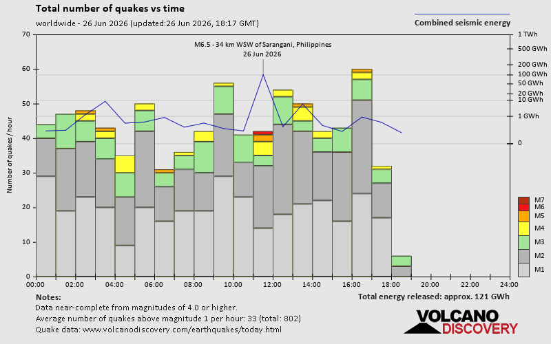 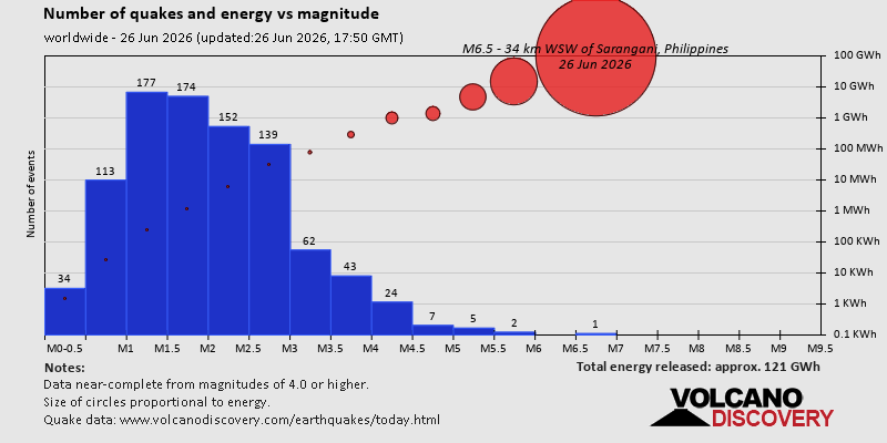 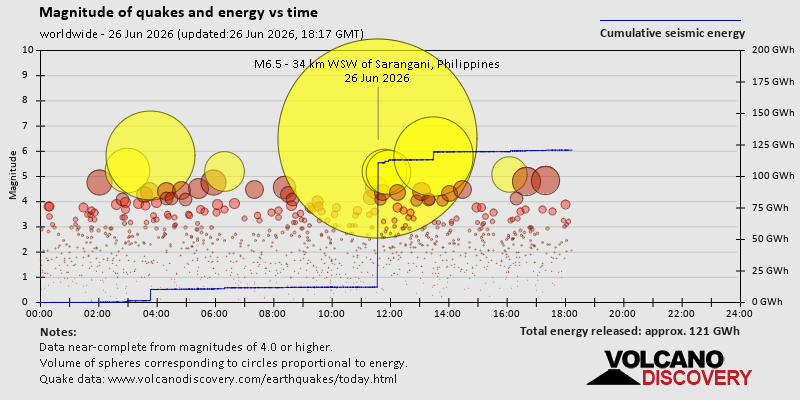 https://www.volcanodiscovery.com/earthquake/news/317762/World-Earthquake-Report-for-Friday-26-June-2026.html https://www.volcanodiscovery.com/earthquake/news/317762/World-Earthquake-Report-for-Friday-26-June-2026.html
0
3
Read More
|
Significant 5.0 quake hits near La Romana, Provincia de La Romana, Dominican Republic
Webmaster
4 hours ago
Significant 5.0 quake hits near La Romana, Provincia de La Romana, Dominican Republic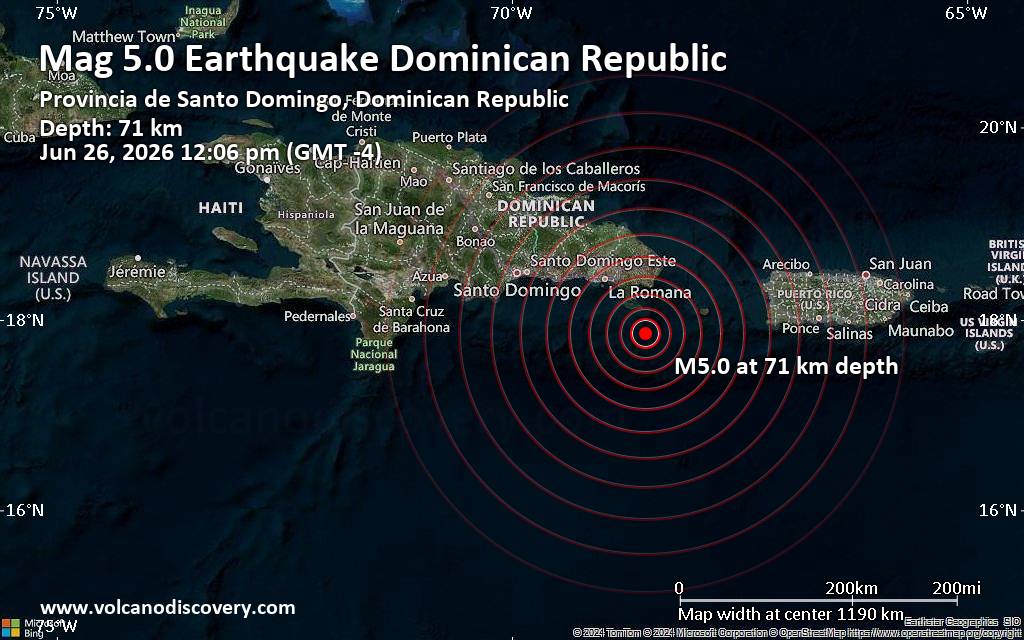 Just 5 minutes ago, a 5.0-magnitude earthquake struck near La Romana, Provincia de La Romana, Dominican Republic. The tremor was recorded around noon on Friday, June 26th, 2026, at 12:06 pm local time, at an intermediate depth of 71.30 km below the surface.
The event was filed by the United States Geological Survey, the first seismological agency to report it.
Based on the preliminary seismic data, the quake should not have caused any significant damage, but was probably felt by many people as light vibration in the area of the epicenter.
Weak shaking might have been felt in Boca de Yuma (pop. 2,000) located 58 km from the epicenter, San Rafael del Yuma (pop. 5,300) 65 km away, La Romana (pop. 208,400) 78 km away, Punta Cana (pop. 100,000) 82 km away, and Salvaleon de Higueey (pop. 123,800) 86 km away.
Other towns or cities near the epicenter where the quake might have been felt as very weak shaking include San Pedro de Macoris (pop. 217,900) located 105 km from the epicenter.
VolcanoDiscovery will automatically update magnitude and depth if these change and follow up if other significant news about the quake become available. If you’re in the area, please send us your experience through our reporting mechanism, either online or via our mobile app. This will help us provide more first-hand updates to anyone around the globe who wants to know more about this quake.
Earthquake data: Date & time: Jun 26, 2026 12:06 pm (GMT -4) local time (26 Jun 2026 16:06 GMT)Magnitude: 5.0 Depth: 71.30 km Epicenter latitude / longitude: 17.86°N / 68.54°W  ( Provincia de San Cristobal, Dominican Republic) Primary data source: USGShttps://www.volcanodiscovery.com/earthquake/news/317801/Significant-50-quake-hits-near-La-Romana-Provincia-de-La-Romana-Dominican-Republic.html
0
6
Read More
|
|
Forums60
Topics784,244
Posts819,009
Members2,960
| |
Most Online22,463
May 9th, 2026
|
|
|


 - Click image for larger picture.")


