|
|
|
0 members (),
3,587
guests, and
22
robots. |
|
Key:
Admin,
Global Mod,
Mod
|
|
S |
M |
T |
W |
T |
F |
S |
|
1
|
2
|
3
|
4
|
5
|
6
|
7
|
|
8
|
9
|
10
|
11
|
12
|
13
|
14
|
|
15
|
16
|
17
|
18
|
19
|
20
|
21
|
|
22
|
23
|
24
|
25
|
26
|
27
|
28
|
|
There are no members with birthdays on this day. |
 Volcano earthquake report for Friday, 27 Feb 2026
Webmaster
4 hours ago
Volcano earthquake report for Friday, 27 Feb 2026
Webmaster
4 hours ago
Volcano earthquake report for Friday, 27 Feb 2026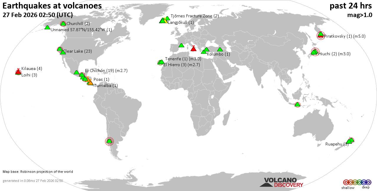 World map showing volcanoes with shallow (less than 50 km) earthquakes within 20 km radius during the past 24 hours on 27 Feb 2026 Number in brackets indicate nr of quakes. Quakes detected near: Apaneca Range (2 quakes between mag 2.4-3.0), Baluran (1 quake mag 2.4), Churchill (2 quakes between mag 1.9-2.0), Clear Lake (23 quakes between mag 0.2-2.1), Coso (2 quakes between mag 0.6-1.1), Ebeko (1 quake mag 3.0)
El Chichón (14 quakes between mag 2.1-2.5), El Hierro (4 quakes between mag 2.5-2.7), Eldey (5 quakes between mag 1.0-1.4), Hiuchi (2 quakes between mag 3.0-3.0), Katla (4 quakes between mag 0.3-1.5), Kenger (1 quake mag 1.1), Kilauea (5 quakes between mag 1.7-2.0), Kolumbo (3 quakes between mag 0.0-1.7), Krísuvík (3 quakes between mag 0.1-1.5), Langjökull (1 quake mag 1.1), Ljósufjöll (2 quakes between mag 0.1-1.8), Llaima (1 quake mag 3.0), Loihi (3 quakes between mag 1.8-2.1), Miravalles (1 quake mag 1.7), Nemrut Dagi (1 quake mag 1.7), Olot Field (1 quake mag 1.7), Ontake-san (1 quake mag 3.0), Papayo (1 quake mag 3.0), Piratkovsky (1 quake mag 5.0), Poas (1 quake mag 1.9), Ruapehu (3 quakes between mag 0.5-1.3), San Cristobal (1 quake mag 1.4), Sandal (1 quake mag 1.1), Stromboli (1 quake mag 1.6), Tajumulco (1 quake mag 3.0), Tjörnes Fracture Zone (3 quakes between mag 0.8-1.6), Tongariro (1 quake mag 1.4), Torfajökull (4 quakes between mag 0.8-1.4), Turrialba (1 quake mag 1.8), Washiba-Kumonotaira (1 quake mag 3.0), Whale Island (1 quake mag 2.1) (updated 00h50)
Note: Earthquakes within 20 km from and at depths less than 50 km under active volcanoes are reported. The list is not complete because many volcanoes are not monitored and/or seismic data in high resolution is not available publicly.
Volcanoes with recent earthquakes above magnitude 2 or more than 10 quakes are listed below:
Apaneca Range volcano (El Salvador): 2 earthquakes up to magnitude 3.02 earthquakes occurred near (under) the volcano during 59 seconds, the last being recorded quake 19 hours ago. Hypocenter depths ranged between 6.00 and 3.00 km. Earthquake details: 3.0 quake 19 km north of Sonsonate, Departamento de Sonsonate, El Salvador, Feb 25, 2026 11:37 pm (GMT -6) (3 km E) 2.4 quake 19 km north of Sonsonate, Departamento de Sonsonate, El Salvador, Feb 25, 2026 11:38 pm (GMT -6) (4 km ESE) All earthquakes at Apaneca RangeBaluran volcano (East Java): magnitude 2.4 earthquakeA magnitude 2.4 earthquake occurred at the volcano 18 hours ago. The quake, which might be volcanic in origin, was located at a depth of 13.00 km depth at 7 km distance E from the volcano. Earthquake details: 2.4 quake Kabupaten Situbondo, 17 km north of Wongsorejo, Indonesia, Feb 26, 2026 02:19 pm (GMT +7) (7 km E) All earthquakes at BaluranClear Lake volcano (California): 23 earthquakes up to magnitude 2.1Possible earthquake swarm: 23 earthquakes occurred near (under) the volcano during 21 hours, the last being recorded quake 18 minutes ago. Hypocenter depths ranged between 9.43 and 0.21 km. Earthquake details: (only 5 largest) 2.1 quake Sonoma County, 14 mi southwest of Clearlake, Lake County, California, United States, Feb 25, 2026 07:58 pm (GMT -8) (17 km SSW) 1.5 quake 26 mi north of Santa Rosa, Sonoma County, California, United States, Feb 26, 2026 12:49 am (GMT -8) (18 km SSW) 1.3 quake 26 mi north of Santa Rosa, Sonoma County, California, United States, Feb 25, 2026 11:21 pm (GMT -8) (18 km SSW) 1.2 quake 26 mi north of Santa Rosa, Sonoma County, California, United States, Feb 26, 2026 04:15 pm (GMT -8) (17 km S) 1.0 quake 27 mi north of Santa Rosa, Sonoma County, California, United States, Feb 25, 2026 07:59 pm (GMT -8) (17 km SSW) All earthquakes at Clear LakeEbeko volcano (Paramushir Island): magnitude 3.0 earthquakeA magnitude 3.0 earthquake occurred at the volcano 17 hours ago. The quake, which might be volcanic in origin, was located at a depth of 10.00 km depth at 6 km distance ESE from the volcano. Earthquake details: Reported seismic-like event (likely no quake): 1.3 km southwest of Kasivobara, Sakhalin Oblast, Russia, Feb 26, 2026 06:45 pm (GMT +11) (6 km ESE) All earthquakes at EbekoEl Chichón volcano (Southern Mexico): 14 earthquakes up to magnitude 2.5Possible earthquake swarm: 14 earthquakes occurred near (under) the volcano during 33 minutes, the last being recorded quake 14 hours ago. Hypocenter depths ranged between 3.10 and 2.30 km. Earthquake details: (only 5 largest) 2.5 quake Estado de Chiapas, 36 km southwest of Teapa, Estado de Tabasco, Mexico, Feb 26, 2026 04:28 am (GMT -6) (1 km N) 2.5 quake Estado de Chiapas, 35 km southwest of Teapa, Estado de Tabasco, Mexico, Feb 26, 2026 04:31 am (GMT -6) (2 km NNE) 2.5 quake Estado de Chiapas, 35 km southwest of Teapa, Estado de Tabasco, Mexico, Feb 26, 2026 04:36 am (GMT -6) (2 km N) 2.4 quake Estado de Chiapas, 36 km southwest of Teapa, Estado de Tabasco, Mexico, Feb 26, 2026 04:37 am (GMT -6) (1 km N) 2.3 quake Estado de Chiapas, 36 km southwest of Teapa, Estado de Tabasco, Mexico, Feb 26, 2026 04:31 am (GMT -6) (1 km N) All earthquakes at El ChichónEl Hierro volcano (Canary Islands): 4 earthquakes up to magnitude 2.74 earthquakes occurred near (under) the volcano during 19 hours, the last being recorded quake 3 hours ago. Hypocenter depths ranged between 30.10 and 27.10 km. Earthquake details: 2.7 quake 9.7 km southwest of Frontera, Santa Cruz de Tenerife, Canary Islands, Spain, Feb 26, 2026 09:27 pm (Universal Time) (9 km NW) 2.7 quake 12 km south of Frontera, Santa Cruz de Tenerife, Canary Islands, Spain, Feb 26, 2026 02:06 am (Universal Time) (5 km WNW) 2.5 quake 9.2 km southwest of Frontera, Santa Cruz de Tenerife, Canary Islands, Spain, Feb 26, 2026 03:20 pm (Universal Time) (12 km NW) 2.5 quake 14 km southwest of Frontera, Santa Cruz de Tenerife, Canary Islands, Spain, Feb 26, 2026 03:25 am (Universal Time) (12 km WNW) All earthquakes at El HierroHiuchi volcano (Honshu): 2 earthquakes up to magnitude 3.02 earthquakes occurred near (under) the volcano during 1 hour 32 minutes, the last being recorded quake 17 hours ago. Hypocenter depths ranged between 10.00 and 10.00 km. Earthquake details: Unconfirmed earthquake or seismic-like event: Fukushima, 39 km southeast of Uonuma, Niigata, Japan, Feb 26, 2026 05:05 pm (GMT +9) (5 km NW) Reported quake or seismic-like event: 37 km northeast of Numata, Gunma, Japan, Feb 26, 2026 03:33 pm (GMT +9) (6 km WSW) All earthquakes at HiuchiLlaima volcano (Central Chile and Argentina): magnitude 3.0 earthquakeA magnitude 3.0 earthquake occurred at the volcano 20 hours ago. The quake, which might be volcanic in origin, was located at a depth of 10.00 km depth at 16 km distance S from the volcano. Earthquake details: Reported seismic-like event (likely no quake): 31 km east of Cunco, Provincia de Cautin, Region de la Araucania, Chile, Feb 26, 2026 01:27 am (GMT -3) (16 km S) All earthquakes at LlaimaLoihi volcano (Hawai'i (Big Island)): 3 earthquakes up to magnitude 2.13 earthquakes occurred near (under) the volcano during 10 hours, the last being recorded quake 11 hours ago. Hypocenter depths ranged between 41.25 and 31.75 km. Earthquake details: 2.1 quake North Pacific Ocean, 12 mi southeast of Pāhala, Hawaii County, Hawaii, United States, Feb 25, 2026 05:19 pm (GMT -10) (19 km NW) 1.9 quake North Pacific Ocean, 40 mi southeast of of Hawai‘i Island, Hawaii County, Hawaii, United States, Feb 26, 2026 03:41 am (GMT -10) (18 km NW) 1.8 quake North Pacific Ocean, 45 mi south of of Hawai‘i Island, Hawaii County, Hawaii, United States, Feb 26, 2026 12:03 am (GMT -10) (14 km W) All earthquakes at LoihiOntake-san volcano (Honshu): magnitude 3.0 earthquakeA magnitude 3.0 earthquake occurred at the volcano 11 hours ago. The quake, which might be volcanic in origin, was located at a depth of 9.40 km depth at 11 km distance WSW from the volcano. Earthquake details: 3.0 quake Nagano, 14 km northeast of Gero, Gifu, Japan, Feb 26, 2026 10:54 pm (GMT +9) (11 km WSW) All earthquakes at Ontake-sanPapayo volcano (Western & Central Mexico): magnitude 3.0 earthquakeA magnitude 3.0 earthquake occurred at the volcano 21 hours ago. The quake, which might be volcanic in origin, was located at a depth of 10.00 km depth at 6 km distance NNE from the volcano. Earthquake details: Reported seismic-like event (likely no quake): 31 km east of Xico, México, Mexico, Feb 25, 2026 10:16 pm (GMT -6) (6 km NNE) All earthquakes at PapayoPiratkovsky volcano (Southern Kamchatka): magnitude 5.0 earthquakeA magnitude 5.0 earthquake occurred at the volcano 19 hours ago. The quake, which might be volcanic in origin, was located at a depth of 10.00 km depth at 6 km distance SE from the volcano. Earthquake details: 5.0 quake Yelizovskiy Rayon, 206 km south of Petropavlovsk-Kamchatskiy, Kamchatka, Russia, Feb 26, 2026 05:58 pm (GMT +12) (6 km SE) All earthquakes at PiratkovskyTajumulco volcano (Guatemala): magnitude 3.0 earthquakeA magnitude 3.0 earthquake occurred at the volcano 19 hours ago. The quake, which might be volcanic in origin, was located at a depth of 10.00 km depth at 3 km distance NW from the volcano. Earthquake details: Reported seismic-like event (likely no quake): 22 km northeast of Malacatan, Departamento de San Marcos, Guatemala, Feb 25, 2026 11:43 pm (GMT -6) (3 km NW) All earthquakes at TajumulcoWashiba-Kumonotaira volcano (Honshu): magnitude 3.0 earthquakeA magnitude 3.0 earthquake occurred at the volcano 11 hours ago. The quake, which might be volcanic in origin, was located at a depth of 10.00 km depth at 3 km distance NNE from the volcano. Earthquake details: Reported quake or seismic-like event: Toyama, 41 km northwest of Matsumoto, Nagano, Japan, Feb 26, 2026 10:54 pm (GMT +9) (3 km NNE) All earthquakes at Washiba-KumonotairaWhale Island volcano (New Zealand): magnitude 2.1 earthquakeA magnitude 2.1 earthquake occurred at the volcano 6 hours ago. The quake, which might be volcanic in origin, was located at a depth of 4.20 km depth at 6 km distance SSW from the volcano. Earthquake details: 2.1 quake South Pacific Ocean, 6.8 km northwest of Whakatane, Bay of Plenty, New Zealand, Feb 27, 2026 07:47 am (GMT +13) (6 km SSW) All earthquakes at Whale Islandhttps://www.volcanodiscovery.com/earthquakes-volcanoes/news/296067/Volcano-earthquake-report-for-Friday-27-Feb-2026.html
0
6
Read More
|
SPC Feb 27, 2026 0100 UTC Day 1 Convective Outlook
Webmaster
4 hours ago
SPC Feb 27, 2026 0100 UTC Day 1 Convective OutlookSPC 0100Z Day 1 Outlook 
Day 1 Convective Outlook
NWS Storm Prediction Center Norman OK
0635 PM CST Thu Feb 26 2026

Valid 270100Z - 271200Z

...THERE IS A MARGINAL RISK OF SEVERE THUNDERSTORMS FROM THE
ARKLATEX TO NORTH-CENTRAL ALABAMA...

...SUMMARY...
Scattered thunderstorms, a few severe, are expected to continue from
the ArkLaMiss into north-central Alabama this evening. A few storms
may produce hail and locally strong wind gusts.

...01z Update...

Notable midlevel short-wave trough is digging southeast across
northern OK/southern MO early this evening. Synoptic front has
settled south to a position from southeast TN-northern MS-central
AR. While LLJ is primarily focused off the NC coast, weak low-level
warm advection is noted across the Mid-south ahead of the
progressive short wave. Scattered convection has developed along
this corridor, and several supercells are noted from east central AR
to northern AL. Latest MRMS data suggests large hail is observed
with the most robust updrafts golf ball size hail has been reported
with a few of these supercells. While scattered convection will
continue ahead of the digging short wave, nocturnal cooling should
begin to affect updraft strength a bit such that overall intensity
of this activity is expected to gradually weaken. Even so, hail/wind
are expected through at least mid evening until low-level lapse
rates begin to adjust to cooling surface temperatures.

..Darrow.. 02/27/2026
Read morehttps://www.spc.noaa.gov/products/outlook/day1otlk_0100.html
0
2
Read More
|
World Earthquake Report for Thursday, 26 February 2026
Webmaster
4 hours ago
World Earthquake Report for Thursday, 26 February 2026 Worldwide earthquakes above magnitude 3 during the past 24 hours on 27 Feb 2026 Magnitude 5+: 5 earthquakes Magnitude 4+: 45 earthquakes Magnitude 3+: 96 earthquakes Magnitude 2+: 338 earthquakes No quakes of magnitude 6 or higher 10 largest earthquakes in the world (26 Feb 2026)Thursday, Feb 26, 2026, at 03:59 pm (GMT +11) - Thursday, Feb 26, 2026, at 03:49 pm (GMT +13) - Thursday, Feb 26, 2026, at 05:04 pm (GMT +10) - Thursday, Feb 26, 2026, at 05:58 pm (GMT +12) - Friday, Feb 27, 2026, at 03:04 am (GMT +10) - Thursday, Feb 26, 2026, at 06:07 am (Santiago time) - Friday, Feb 27, 2026, at 03:51 am (GMT +9) - Thursday, Feb 26, 2026, at 11:34 am (Kolkata time) - Thursday, Feb 26, 2026, at 01:39 pm (GMT +8) - Friday, Feb 27, 2026, at 03:29 am (GMT +12) - Earthquakes reported feltThursday, Feb 26, 2026, at 12:26 pm (Universal Time) - Thursday, Feb 26, 2026, at 12:17 pm (GMT -5) - Friday, Feb 27, 2026, at 04:10 am (GMT +5:30) - Thursday, Feb 26, 2026, at 11:34 am (Kolkata time) - Thursday, Feb 26, 2026, at 07:21 pm (GMT +2) - Thursday, Feb 26, 2026, at 06:21 pm (GMT -5) - Thursday, Feb 26, 2026, at 10:10 pm (GMT +5:30) - Thursday, Feb 26, 2026, at 08:17 pm (Istanbul time) - Wednesday, Feb 25, 2026, at 04:20 pm (GMT -8) - Friday, Feb 27, 2026, at 01:43 am (GMT +11) - Thursday, Feb 26, 2026, at 05:22 pm (GMT +5:30) - Thursday, Feb 26, 2026, at 12:32 pm (Universal Time) - Friday, Feb 27, 2026, at 03:03 am (GMT +5:30) - Wednesday, Feb 25, 2026, at 11:37 pm (GMT -6) - Thursday, Feb 26, 2026, at 06:07 am (Santiago time) - Thursday, Feb 26, 2026, at 03:59 pm (GMT +11) - Thursday, Feb 26, 2026, at 11:42 am (GMT -7) - Thursday, Feb 26, 2026, at 08:52 pm (GMT +2) - Friday, Feb 27, 2026, at 12:24 am (GMT +8) - Thursday, Feb 26, 2026, at 02:43 pm (GMT +2) - Thursday, Feb 26, 2026, at 12:17 pm (Kolkata time) - Thursday, Feb 26, 2026, at 06:48 pm (GMT -5) - Thursday, Feb 26, 2026, at 01:12 pm (GMT +5:30) - Wednesday, Feb 25, 2026, at 06:05 pm (GMT -6) - Wednesday, Feb 25, 2026, at 08:52 pm (GMT -10) - Wednesday, Feb 25, 2026, at 05:43 pm (GMT -8) - Thursday, Feb 26, 2026, at 07:32 am (GMT -3) - Thursday, Feb 26, 2026, at 11:41 am (Kolkata time) - Thursday, Feb 26, 2026, at 12:39 pm (Kolkata time) - Earthquake stats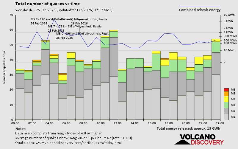 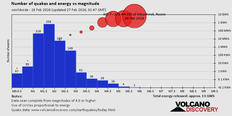 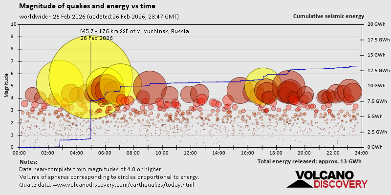 https://www.volcanodiscovery.com/earthquake/news/295968/World-Earthquake-Report-for-Thursday-26-February-2026.html https://www.volcanodiscovery.com/earthquake/news/295968/World-Earthquake-Report-for-Thursday-26-February-2026.html
0
8
Read More
|
Volcano earthquake report for Thursday, 26 Feb 2026
Webmaster
Yesterday at 11:50 PM
Volcano earthquake report for Thursday, 26 Feb 2026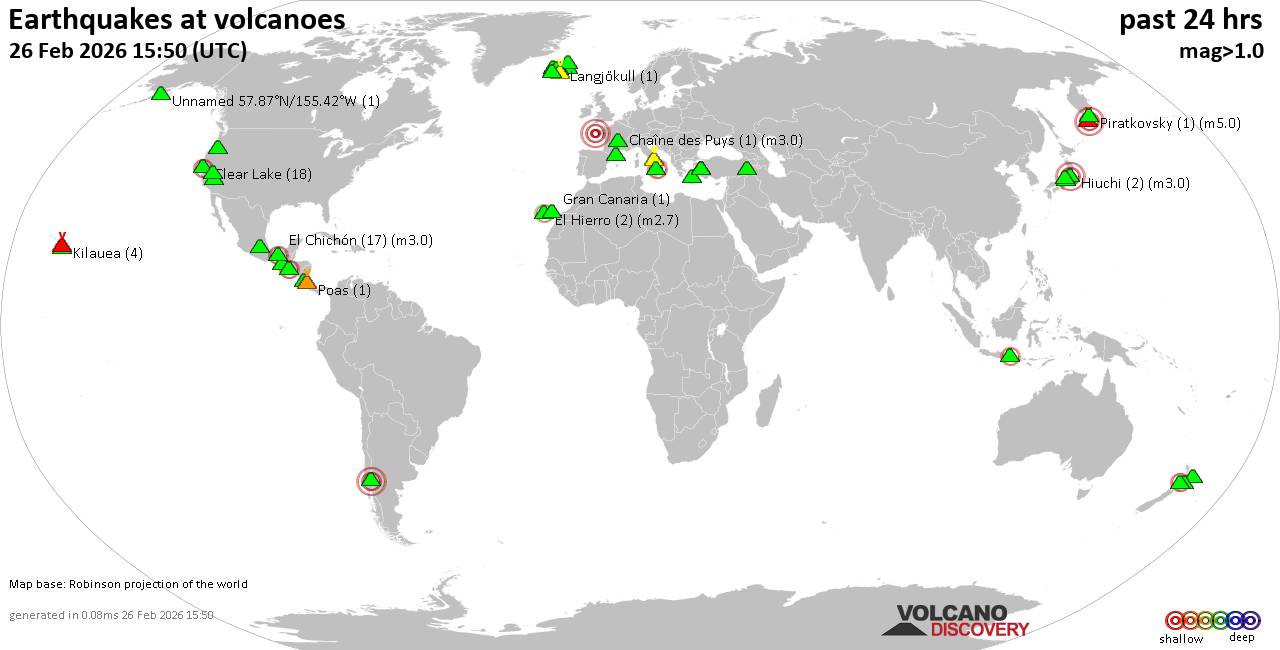 World map showing volcanoes with shallow (less than 50 km) earthquakes within 20 km radius during the past 24 hours on 26 Feb 2026 Number in brackets indicate nr of quakes. Quakes detected near: Apaneca Range (2 quakes between mag 2.4-3.0), Baluran (1 quake mag 2.4), Churchill (2 quakes between mag 1.9-2.0), Clear Lake (21 quakes between mag 0.2-2.1), Coso (2 quakes between mag 0.6-1.1), Ebeko (1 quake mag 3.0)
El Chichón (14 quakes between mag 2.1-2.5), El Hierro (4 quakes between mag 2.5-2.7), Eldey (5 quakes between mag 1.0-1.4), Hiuchi (2 quakes between mag 3.0-3.0), Katla (4 quakes between mag 0.3-1.5), Kenger (1 quake mag 1.1), Kilauea (5 quakes between mag 1.7-2.0), Kolumbo (3 quakes between mag 0.0-1.7), Krísuvík (3 quakes between mag 0.1-1.5), Langjökull (1 quake mag 1.1), Ljósufjöll (3 quakes between mag 0.1-1.8), Llaima (1 quake mag 3.0), Loihi (3 quakes between mag 1.8-2.1), Miravalles (1 quake mag 1.7), Nemrut Dagi (1 quake mag 1.7), Olot Field (1 quake mag 1.7), Ontake-san (1 quake mag 3.0), Papayo (1 quake mag 3.0), Piratkovsky (1 quake mag 5.0), Poas (1 quake mag 1.9), Ruapehu (2 quakes between mag 1.0-1.3), San Cristobal (1 quake mag 1.4), Sandal (1 quake mag 1.1), Stromboli (1 quake mag 1.6), Tajumulco (1 quake mag 3.0), Tjörnes Fracture Zone (3 quakes between mag 0.8-1.6), Tongariro (1 quake mag 1.4), Torfajökull (4 quakes between mag 0.8-1.4), Turrialba (1 quake mag 1.8), Washiba-Kumonotaira (1 quake mag 3.0), Whale Island (1 quake mag 2.1) (updated 23h50)
Note: Earthquakes within 20 km from and at depths less than 50 km under active volcanoes are reported. The list is not complete because many volcanoes are not monitored and/or seismic data in high resolution is not available publicly.
Volcanoes with recent earthquakes above magnitude 2 or more than 10 quakes are listed below:
Apaneca Range volcano (El Salvador): 2 earthquakes up to magnitude 3.02 earthquakes occurred near (under) the volcano during 59 seconds, the last being recorded quake 18 hours ago. Hypocenter depths ranged between 6.00 and 3.00 km. Earthquake details: 3.0 quake 19 km north of Sonsonate, Departamento de Sonsonate, El Salvador, Feb 25, 2026 11:37 pm (GMT -6) (3 km E) 2.4 quake 19 km north of Sonsonate, Departamento de Sonsonate, El Salvador, Feb 25, 2026 11:38 pm (GMT -6) (4 km ESE) All earthquakes at Apaneca RangeBaluran volcano (East Java): magnitude 2.4 earthquakeA magnitude 2.4 earthquake occurred at the volcano 17 hours ago. The quake, which might be volcanic in origin, was located at a depth of 13.00 km depth at 7 km distance E from the volcano. Earthquake details: 2.4 quake Kabupaten Situbondo, 17 km north of Wongsorejo, Indonesia, Feb 26, 2026 02:19 pm (GMT +7) (7 km E) All earthquakes at BaluranClear Lake volcano (California): 21 earthquakes up to magnitude 2.1Possible earthquake swarm: 21 earthquakes occurred near (under) the volcano during 22 hours, the last being recorded quake 1 hour 25 minutes ago. Hypocenter depths ranged between 9.43 and 1.33 km. Earthquake details: (only 5 largest) 2.1 quake Sonoma County, 14 mi southwest of Clearlake, Lake County, California, United States, Feb 25, 2026 07:58 pm (GMT -8) (17 km SSW) 1.5 quake 26 mi north of Santa Rosa, Sonoma County, California, United States, Feb 26, 2026 12:49 am (GMT -8) (18 km SSW) 1.3 quake 26 mi north of Santa Rosa, Sonoma County, California, United States, Feb 25, 2026 11:21 pm (GMT -8) (18 km SSW) 1.0 quake Lake County, 27 mi north of Santa Rosa, Sonoma County, California, United States, Feb 25, 2026 08:24 pm (GMT -8) (16 km S) 1.0 quake 28 mi north of Santa Rosa, Sonoma County, California, United States, Feb 26, 2026 11:14 am (GMT -8) (16 km SSW) All earthquakes at Clear LakeEbeko volcano (Paramushir Island): magnitude 3.0 earthquakeA magnitude 3.0 earthquake occurred at the volcano 16 hours ago. The quake, which might be volcanic in origin, was located at a depth of 10.00 km depth at 6 km distance ESE from the volcano. Earthquake details: Reported seismic-like event (likely no quake): 1.3 km southwest of Kasivobara, Sakhalin Oblast, Russia, Feb 26, 2026 06:45 pm (GMT +11) (6 km ESE) All earthquakes at EbekoEl Chichón volcano (Southern Mexico): 14 earthquakes up to magnitude 2.5Possible earthquake swarm: 14 earthquakes occurred near (under) the volcano during 33 minutes, the last being recorded quake 13 hours ago. Hypocenter depths ranged between 3.10 and 2.30 km. Earthquake details: (only 5 largest) 2.5 quake Estado de Chiapas, 36 km southwest of Teapa, Estado de Tabasco, Mexico, Feb 26, 2026 04:28 am (GMT -6) (1 km N) 2.5 quake Estado de Chiapas, 35 km southwest of Teapa, Estado de Tabasco, Mexico, Feb 26, 2026 04:31 am (GMT -6) (2 km NNE) 2.5 quake Estado de Chiapas, 35 km southwest of Teapa, Estado de Tabasco, Mexico, Feb 26, 2026 04:36 am (GMT -6) (2 km N) 2.4 quake Estado de Chiapas, 36 km southwest of Teapa, Estado de Tabasco, Mexico, Feb 26, 2026 04:37 am (GMT -6) (1 km N) 2.3 quake Estado de Chiapas, 36 km southwest of Teapa, Estado de Tabasco, Mexico, Feb 26, 2026 04:31 am (GMT -6) (1 km N) All earthquakes at El ChichónEl Hierro volcano (Canary Islands): 4 earthquakes up to magnitude 2.74 earthquakes occurred near (under) the volcano during 19 hours, the last being recorded quake 2 hours ago. Hypocenter depths ranged between 30.10 and 27.10 km. Earthquake details: 2.7 quake 9.7 km southwest of Frontera, Santa Cruz de Tenerife, Canary Islands, Spain, Feb 26, 2026 09:27 pm (Universal Time) (9 km NW) 2.7 quake 12 km south of Frontera, Santa Cruz de Tenerife, Canary Islands, Spain, Feb 26, 2026 02:06 am (Universal Time) (5 km WNW) 2.5 quake 9.2 km southwest of Frontera, Santa Cruz de Tenerife, Canary Islands, Spain, Feb 26, 2026 03:20 pm (Universal Time) (12 km NW) 2.5 quake 14 km southwest of Frontera, Santa Cruz de Tenerife, Canary Islands, Spain, Feb 26, 2026 03:25 am (Universal Time) (12 km WNW) All earthquakes at El HierroHiuchi volcano (Honshu): 2 earthquakes up to magnitude 3.02 earthquakes occurred near (under) the volcano during 1 hour 32 minutes, the last being recorded quake 16 hours ago. Hypocenter depths ranged between 10.00 and 10.00 km. Earthquake details: Unconfirmed earthquake or seismic-like event: Fukushima, 39 km southeast of Uonuma, Niigata, Japan, Feb 26, 2026 05:05 pm (GMT +9) (5 km NW) Reported quake or seismic-like event: 37 km northeast of Numata, Gunma, Japan, Feb 26, 2026 03:33 pm (GMT +9) (6 km WSW) All earthquakes at HiuchiLlaima volcano (Central Chile and Argentina): magnitude 3.0 earthquakeA magnitude 3.0 earthquake occurred at the volcano 19 hours ago. The quake, which might be volcanic in origin, was located at a depth of 10.00 km depth at 16 km distance S from the volcano. Earthquake details: Reported seismic-like event (likely no quake): 31 km east of Cunco, Provincia de Cautin, Region de la Araucania, Chile, Feb 26, 2026 01:27 am (GMT -3) (16 km S) All earthquakes at LlaimaLoihi volcano (Hawai'i (Big Island)): 3 earthquakes up to magnitude 2.13 earthquakes occurred near (under) the volcano during 10 hours, the last being recorded quake 10 hours ago. Hypocenter depths ranged between 41.25 and 31.75 km. Earthquake details: 2.1 quake North Pacific Ocean, 12 mi southeast of Pāhala, Hawaii County, Hawaii, United States, Feb 25, 2026 05:19 pm (GMT -10) (19 km NW) 1.9 quake North Pacific Ocean, 40 mi southeast of of Hawai‘i Island, Hawaii County, Hawaii, United States, Feb 26, 2026 03:41 am (GMT -10) (18 km NW) 1.8 quake North Pacific Ocean, 45 mi south of of Hawai‘i Island, Hawaii County, Hawaii, United States, Feb 26, 2026 12:03 am (GMT -10) (14 km W) All earthquakes at LoihiOntake-san volcano (Honshu): magnitude 3.0 earthquakeA magnitude 3.0 earthquake occurred at the volcano 10 hours ago. The quake, which might be volcanic in origin, was located at a depth of 9.40 km depth at 11 km distance WSW from the volcano. Earthquake details: 3.0 quake Nagano, 14 km northeast of Gero, Gifu, Japan, Feb 26, 2026 10:54 pm (GMT +9) (11 km WSW) All earthquakes at Ontake-sanPapayo volcano (Western & Central Mexico): magnitude 3.0 earthquakeA magnitude 3.0 earthquake occurred at the volcano 20 hours ago. The quake, which might be volcanic in origin, was located at a depth of 10.00 km depth at 6 km distance NNE from the volcano. Earthquake details: Reported seismic-like event (likely no quake): 31 km east of Xico, México, Mexico, Feb 25, 2026 10:16 pm (GMT -6) (6 km NNE) All earthquakes at PapayoPiratkovsky volcano (Southern Kamchatka): magnitude 5.0 earthquakeA magnitude 5.0 earthquake occurred at the volcano 18 hours ago. The quake, which might be volcanic in origin, was located at a depth of 10.00 km depth at 6 km distance SE from the volcano. Earthquake details: 5.0 quake Yelizovskiy Rayon, 206 km south of Petropavlovsk-Kamchatskiy, Kamchatka, Russia, Feb 26, 2026 05:58 pm (GMT +12) (6 km SE) All earthquakes at PiratkovskyTajumulco volcano (Guatemala): magnitude 3.0 earthquakeA magnitude 3.0 earthquake occurred at the volcano 18 hours ago. The quake, which might be volcanic in origin, was located at a depth of 10.00 km depth at 3 km distance NW from the volcano. Earthquake details: Reported seismic-like event (likely no quake): 22 km northeast of Malacatan, Departamento de San Marcos, Guatemala, Feb 25, 2026 11:43 pm (GMT -6) (3 km NW) All earthquakes at TajumulcoWashiba-Kumonotaira volcano (Honshu): magnitude 3.0 earthquakeA magnitude 3.0 earthquake occurred at the volcano 10 hours ago. The quake, which might be volcanic in origin, was located at a depth of 10.00 km depth at 3 km distance NNE from the volcano. Earthquake details: Reported quake or seismic-like event: Toyama, 41 km northwest of Matsumoto, Nagano, Japan, Feb 26, 2026 10:54 pm (GMT +9) (3 km NNE) All earthquakes at Washiba-KumonotairaWhale Island volcano (New Zealand): magnitude 2.1 earthquakeA magnitude 2.1 earthquake occurred at the volcano 5 hours ago. The quake, which might be volcanic in origin, was located at a depth of 4.20 km depth at 6 km distance SSW from the volcano. Earthquake details: 2.1 quake South Pacific Ocean, 6.8 km northwest of Whakatane, Bay of Plenty, New Zealand, Feb 27, 2026 07:47 am (GMT +13) (6 km SSW) All earthquakes at Whale Islandhttps://www.volcanodiscovery.com/earthquakes-volcanoes/news/295959/Volcano-earthquake-report-for-Thursday-26-Feb-2026.html
0
7
Read More
|
Moderate magnitude 4.4 quake hits 58 km northeast of Chosica, Peru early evening
Webmaster
Yesterday at 11:49 PM
Moderate magnitude 4.4 quake hits 58 km northeast of Chosica, Peru early evening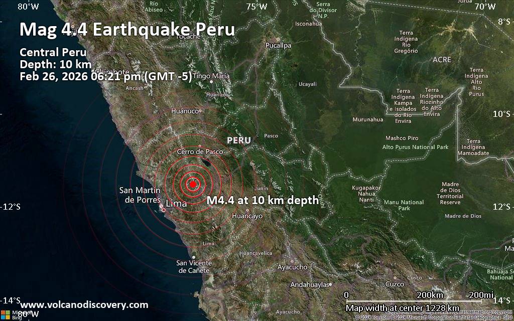 A magnitude 4.4 earthquake near Chosica, Lima, Lima region, Peru, was reported only 27 minutes ago by the German Research Centre for Geosciences (GFZ), considered one of the key international agencies that monitor seismic activity worldwide. The earthquake occurred at a shallow depth of 10. km beneath the epicenter early evening on Thursday, February 26th, 2026, at 6:21 pm local time. The exact magnitude, epicenter, and depth of the quake might be revised within the next few hours or minutes as seismologists review data and refine their calculations, or as other agencies issue their report.
Our monitoring service identified a second report from The Colombian Geological Service (SGC) which listed the quake at magnitude 4.8. A third agency, the citizen-seismograph network of RaspberryShake, reported the same quake at magnitude 4.4.
Based on the preliminary seismic data, the quake was probably felt by many people in the area of the epicenter. It should not have caused significant damage, other than objects falling from shelves, broken windows, etc.
In Marcapomacocha (pop. 360) located 14 km from the epicenter, the quake should have been felt as light shaking.
Weak shaking might have been felt in La Oroya (pop. 33,300) located 55 km from the epicenter.
Other towns or cities near the epicenter where the quake might have been felt as very weak shaking include Chosica (pop. 88,600) located 58 km from the epicenter, Junin (pop. 15,300) 60 km away, Tarma (pop. 51,400) 79 km away, Santa Anita - Los Ficus (pop. 184,600) 86 km away, Lima (pop. 7,737,000) 90 km away, San Francisco De Borja (pop. 105,100) 91 km away, Brena (pop. 81,900) 93 km away, and Callao (pop. 1,300,000) 99 km away.
VolcanoDiscovery will automatically update magnitude and depth if these change and follow up if other significant news about the quake become available. If you’re in the area, please send us your experience through our reporting mechanism, either online or via our mobile app. This will help us provide more first-hand updates to anyone around the globe who wants to know more about this quake.
Earthquake data: Date & time: Feb 26, 2026 06:21 pm (GMT -5) local time (26 Feb 2026 23:21 GMT)Magnitude: 4.4 Depth: 10.00 km Epicenter latitude / longitude: 11.52°S / 76.41°W  (Daniel Alcides Carrion, Lima region, Peru) Primary data source: GFZhttps://www.volcanodiscovery.com/earthquake/news/296061/Moderate-magnitude-44-quake-hits-58-km-northeast-of-Chosica-Peru-early-evening-.html
0
9
Read More
|
Moderate magnitude 4.3 quake hits 24 km northeast of Gangtok, India early morning
Webmaster
Yesterday at 10:58 PM
Moderate magnitude 4.3 quake hits 24 km northeast of Gangtok, India early morning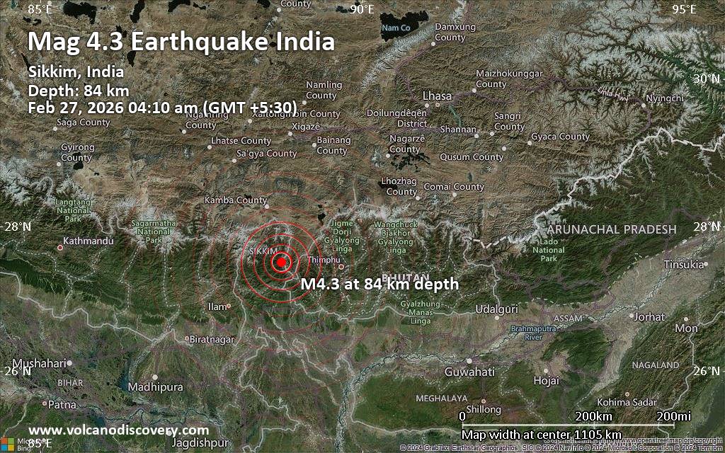 The European-Mediterranean Seismological Centre (EMSC) reported a magnitude 4.3 quake in India near Gangtok, Gangtok district, Sikkim, only 17 minutes ago. The earthquake hit early morning on Friday, February 27th, 2026, at 3:40 am local time at an intermediate depth of 84. km. The exact magnitude, epicenter, and depth of the quake might be revised within the next few hours or minutes as seismologists review data and refine their calculations, or as other agencies issue their report.
A second report was later issued by India's National Center for Seismology (NCS), which listed it as a magnitude 3.7 earthquake.
Towns or cities near the epicenter where the quake might have been felt as very weak shaking include Mangan (pop. 4,600) located 22 km from the epicenter, Gangtok (pop. 100,300) 24 km away, Rangpo (pop. 10,500) 42 km away, Kalimpong (pop. 43,000) 55 km away, Darjiling (pop. 123,800) 71 km away, Kurseong (pop. 46,400) 83 km away, Thimphu (pop. 98,700) 89 km away, Siliguri (pop. 515,600) 94 km away, Goyerkata (pop. 66,400) 94 km away, and Jaigaon (pop. 158,700) 97 km away.
VolcanoDiscovery will automatically update magnitude and depth if these change and follow up if other significant news about the quake become available. If you’re in the area, please send us your experience through our reporting mechanism, either online or via our mobile app. This will help us provide more first-hand updates to anyone around the globe who wants to know more about this quake.
Earthquake data: Date & time: Feb 27, 2026 04:10 am (GMT +5:30) local time (26 Feb 2026 22:40 GMT)Magnitude: 4.3 Depth: 84.00 km Epicenter latitude / longitude: 27.51°N / 88.74°E  ( Mangan, Sikkim, India) Primary data source: EMSChttps://www.volcanodiscovery.com/earthquake/news/296054/Moderate-magnitude-43-quake-hits-24-km-northeast-of-Gangtok-India-early-morning-.html
0
9
Read More
|
|
Forums60
Topics763,585
Posts798,323
Members2,958
| |
Most Online17,963
Jan 15th, 2026
|
|
|
|
|
Copyright 1996 - 2026 by David Cottle. Designed by David Bate Jr. All Rights Reserved.
By using this forum, the user agrees not to transfer any data or technical information received under the agreement, to any other entity without the express approval of the AUS-CITY Forum Admins and/or authors of individual posts (Forum Admins and DoD/USSPACECOM for the analysis of satellite tracking data).
Two-line elements (TLE) and all other satellite data presented and distributed via this forum and e-mail lists of AUS-CITY are distributed with permission from DoD/USSTRATCOM.


Reprise Hosting

|

|


 - Click image for larger picture.")


