|
|
|
0 members (),
7,639
guests, and
24
robots. |
|
Key:
Admin,
Global Mod,
Mod
|
|
S |
M |
T |
W |
T |
F |
S |
|
|
|
|
|
1
|
2
|
3
|
|
4
|
5
|
6
|
7
|
8
|
9
|
10
|
|
11
|
12
|
13
|
14
|
15
|
16
|
17
|
|
18
|
19
|
20
|
21
|
22
|
23
|
24
|
|
25
|
26
|
27
|
28
|
29
|
30
|
31
|
|
There are no members with birthdays on this day. |
 SPC Day 3-8 Fire Weather Outlook
Webmaster
2 hours ago
SPC Day 3-8 Fire Weather Outlook
Webmaster
2 hours ago
SPC Day 3-8 Fire Weather OutlookSPC Day 3-8 Fire Weather Outlook 
Day 3-8 Fire Weather Outlook
NWS Storm Prediction Center Norman OK
0253 PM CST Mon Jan 26 2026

Valid 281200Z - 031200Z

...Synopsis...
Longer term ensemble cluster analysis depicts ongoing broad scale
mid-level troughing east of the Continental Divide through at least
through the weekend, with potentially a more progressive wave
pattern emerging by Day 7 or 8 (Sunday-Monday). Colder temperatures,
antecedent moisture and lingering snow cover should largely mitigate
fire weather concerns east of the High Plains. The persistent
northwest flow aloft could bring occasional downslope warming and
drying events to the central and southern High Plains, but stronger
winds should be localized and limited to adjacent lee slopes of the
southern/central Rockies. Ridging across the West will promote dry
and seasonably warm conditions across much of the Southwest through
early next week.

...Florida...
Surface high pressure settling into the Southern Plains and lower MS
River Valley should keep deeper boundary layer moisture shunted
offshore across the Southeast and Florida. Persistent northerly to
northwesterly flow across FL will likely lead to critically low
relative humidity each day through Friday, but subdued lower-level
wind profiles and diffuse surface pressure gradients should limit
breezier winds from developing. Extended model guidance suggests a
stronger surface cyclone developing near FL by Day 6/Saturday,
traversing the East Coast into early next week. Stronger north winds
behind a cold front trailing the low is expected Saturday, but
preceding rainfall should mitigate fire weather concerns prior to
this potentially stronger offshore wind event.

..Williams.. 01/26/2026

...Please see www.spc.noaa.gov/fire for graphic product...
Read morehttps://www.spc.noaa.gov/products/exper/fire_wx/
0
5
Read More
|
Volcano earthquake report for Monday, 26 Jan 2026
Webmaster
3 hours ago
Volcano earthquake report for Monday, 26 Jan 2026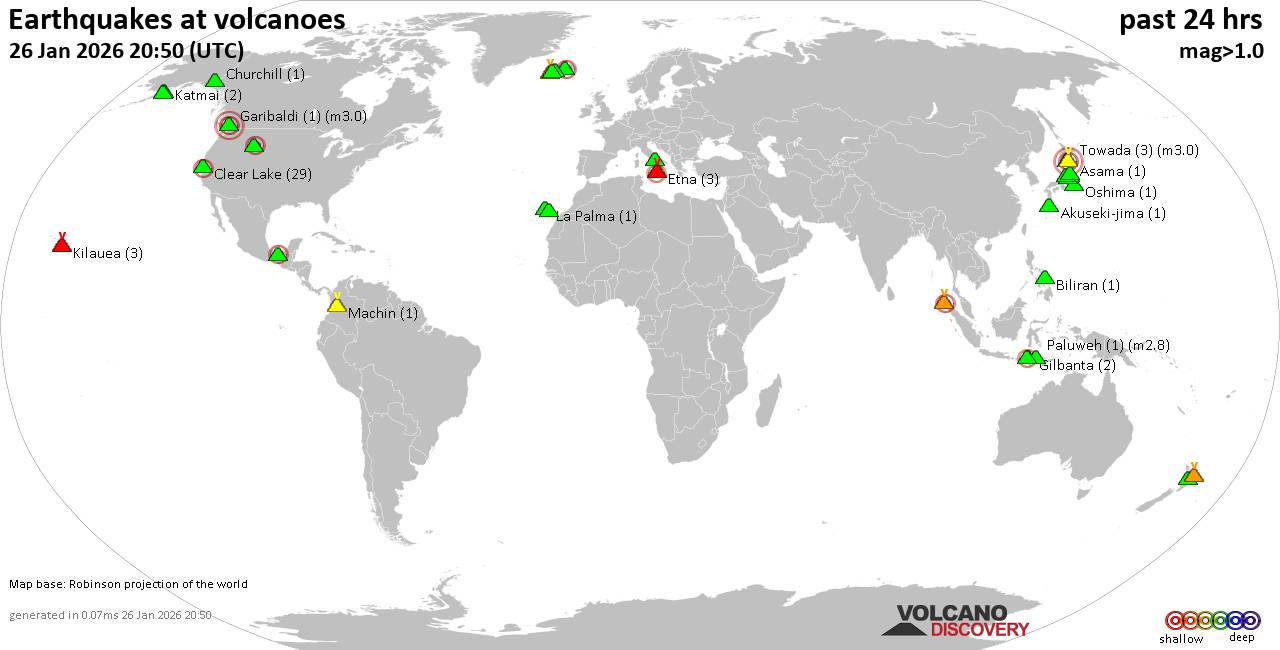 World map showing volcanoes with shallow (less than 50 km) earthquakes within 20 km radius during the past 24 hours on 26 Jan 2026 Number in brackets indicate nr of quakes. Quakes detected near: Akuseki-jima (1 quake mag 1.3), Asama (1 quake mag 1.0), Bardarbunga (2 quakes between mag 0.5-2.1), Biliran (1 quake mag 1.5), Churchill (1 quake mag 1.2), Clear Lake (27 quakes between mag 0.6-2.0)
El Chichón (2 quakes between mag 2.5-2.5), Eldey (2 quakes between mag 2.4-2.9), Etna (2 quakes between mag 1.9-2.1), Garibaldi (1 quake mag 3.0), Gilbanta (2 quakes between mag 2.2-2.4), Hakkoda (1 quake mag 3.0), Hiuchi (2 quakes between mag 0.8-1.1), Hrómundartindur (5 quakes between mag 0.8-1.6), Katmai (2 quakes between mag 0.9-1.1), Kilauea (4 quakes between mag 0.9-1.7), Krísuvík (3 quakes between mag 0.5-1.5), La Palma (1 quake mag 1.6), Machin (1 quake mag 1.3), Mageik (3 quakes between mag 0.1-1.6), Maroa (5 quakes between mag 1.5-2.0), Myoko (2 quakes between mag 0.4-1.9), Numazawa (1 quake mag 2.1), Oshima (1 quake mag 1.0), Paluweh (1 quake mag 2.8), Sangeang Api (1 quake mag 2.1), Tenerife (15 quakes between mag 0.5-2.1), Towada (3 quakes between mag 3.0-3.0), Vesuvius (2 quakes between mag 1.3-1.8), White Island (1 quake mag 2.7), Yellowstone (9 quakes between mag 0.0-2.1) (updated 19h50)
Note: Earthquakes within 20 km from and at depths less than 50 km under active volcanoes are reported. The list is not complete because many volcanoes are not monitored and/or seismic data in high resolution is not available publicly.
Volcanoes with recent earthquakes above magnitude 2 or more than 10 quakes are listed below:
Bardarbunga volcano (Iceland): 2 earthquakes up to magnitude 2.12 earthquakes occurred near (under) the volcano during 6 minutes, the last being recorded quake 17 hours ago. Hypocenter depths ranged between 3.00 and 1.40 km. Earthquake details: 2.1 quake 5.9 km E of Bárðarbunga Jan 26, 2026 03:07 am (Universal Time) (6 km E) 0.5 quake Iceland: 6.1 km ESE of Bárðarbunga Jan 26, 2026 03:12 am (Reykjavik time) (6 km E) All earthquakes at BardarbungaClear Lake volcano (California): 27 earthquakes up to magnitude 2.0Possible earthquake swarm: 27 earthquakes occurred near (under) the volcano during 21 hours, the last being recorded quake 2 hours ago. Hypocenter depths ranged between 11.30 and 0.94 km. Earthquake details: (only 5 largest) 2.0 quake Sonoma County, 13 mi southwest of Clearlake, Lake County, California, United States, Jan 25, 2026 10:25 pm (GMT -8) (16 km SSW) 1.6 quake Sonoma County, 13 mi southwest of Clearlake, Lake County, California, United States, Jan 25, 2026 06:59 pm (GMT -8) (17 km S) 1.4 quake 27 mi north of Santa Rosa, Sonoma County, California, United States, Jan 26, 2026 02:02 am (GMT -8) (17 km S) 1.4 quake 27 mi north of Santa Rosa, Sonoma County, California, United States, Jan 26, 2026 07:45 am (GMT -8) (18 km SSW) 1.3 quake 28 mi north of Santa Rosa, Sonoma County, California, United States, Jan 25, 2026 10:31 pm (GMT -8) (16 km SSW) All earthquakes at Clear LakeEl Chichón volcano (Southern Mexico): 2 earthquakes up to magnitude 2.52 earthquakes occurred near (under) the volcano during 63 seconds, the last being recorded quake 22 hours ago. Hypocenter depths ranged between 3.00 and 3.00 km. Earthquake details: 2.5 quake Estado de Chiapas, 29 km southwest of Teapa, Estado de Tabasco, Mexico, Jan 25, 2026 04:09 pm (GMT -6) (7 km NE) 2.5 quake Estado de Chiapas, 30 km southwest of Teapa, Estado de Tabasco, Mexico, Jan 25, 2026 04:10 pm (GMT -6) (7 km ENE) All earthquakes at El ChichónEldey volcano (Iceland): 2 earthquakes up to magnitude 2.92 earthquakes occurred near (under) the volcano during 8 hours, the last being recorded quake 25 minutes ago. Hypocenter depths ranged between 10.20 and 9.60 km. Earthquake details: 2.9 quake Irminger Sea, 89 km southwest of Reykjavik, Capital Region, Iceland, Jan 26, 2026 11:31 am (Reykjavik time) (19 km WSW) 2.4 quake Iceland: 3.3 km NW of Eldey Jan 26, 2026 07:24 pm (Reykjavik time) (3 km N) All earthquakes at EldeyEldey is located at the beginning of the Reykjanes Ridge off the SW tip of Iceland. Its highest elevation is the top of Eldey Island, but most of the volcanic edifice is submerged. Several eruptions occurred in historic times, last in 1926. Etna volcano (Italy): 2 earthquakes up to magnitude 2.12 earthquakes occurred near (under) the volcano during 7 hours, the last being recorded quake 4 hours ago. Hypocenter depths ranged between 13.08 and 9.40 km. Earthquake details: 2.1 quake 7.7 km north of Adrano, Catania, Sicily, Italy, Jan 26, 2026 09:45 am (GMT +1) (17 km W) 1.9 quake 8.6 km north of Adrano, Catania, Sicily, Italy, Jan 26, 2026 05:02 pm (GMT +1) (16 km W) All earthquakes at EtnaGaribaldi volcano (Canada): magnitude 3.0 earthquakeA magnitude 3.0 earthquake occurred at the volcano 13 hours ago. The quake, which might be volcanic in origin, was located at a depth of 10.00 km depth at 17 km distance SW from the volcano. Earthquake details: Reported quake or seismic-like event: 3.4 km north of Squamish, Squamish-Lillooetal, British Columbia, Canada, Jan 25, 2026 10:58 pm (GMT -8) (17 km SW) All earthquakes at GaribaldiGilbanta volcano (Lesser Sunda Islands): 2 earthquakes up to magnitude 2.42 earthquakes occurred near (under) the volcano during 3 hours, the last being recorded quake 17 hours ago. Hypocenter depths ranged between 15.00 and 14.00 km. Earthquake details: 2.4 quake Flores Sea, 5.7 km north of Gili Banta Island, West Nusa Tenggara, Indonesia, Jan 26, 2026 10:32 am (GMT +8) (6 km NW) 2.2 quake Flores Sea, 14 km north of Gili Banta Island, West Nusa Tenggara, Indonesia, Jan 26, 2026 07:13 am (GMT +8) (12 km N) All earthquakes at GilbantaHakkoda volcano (Honshu): magnitude 3.0 earthquakeA magnitude 3.0 earthquake occurred at the volcano 16 hours ago. The quake, which might be volcanic in origin, was located at a depth of 10.00 km depth at 10 km distance S from the volcano. Earthquake details: Reported quake or seismic-like event: 31 km southeast of Aomori, Aomori, Japan, Jan 26, 2026 12:25 pm (GMT +9) (10 km S) All earthquakes at HakkodaNumazawa volcano (Honshu): magnitude 2.1 earthquakeA magnitude 2.1 earthquake occurred at the volcano 15 hours ago. The quake, which might be volcanic in origin, was located at a depth of 7.10 km depth at 19 km distance ESE from the volcano. Earthquake details: 2.1 quake 3.7 km southwest of Aizu-misato Machi, Fukushima, Japan, Jan 26, 2026 02:17 pm (GMT +9) (19 km ESE) All earthquakes at NumazawaPaluweh volcano (Lesser Sunda Islands): magnitude 2.8 earthquakeA magnitude 2.8 earthquake occurred at the volcano 22 hours ago. The quake, which might be volcanic in origin, was located at a depth of 13.00 km depth at 10 km distance SSE from the volcano. Earthquake details: 2.8 quake Kabupaten Sikka, 50 km north of Ende, Indonesia, Jan 26, 2026 06:02 am (GMT +8) (10 km SSE) All earthquakes at PaluwehSangeang Api volcano (Lesser Sunda Islands): magnitude 2.1 earthquakeA magnitude 2.1 earthquake occurred at the volcano 19 hours ago. The quake, which might be volcanic in origin, was located at a depth of 36.00 km depth at 17 km distance NNW from the volcano. Earthquake details: 2.1 quake Flores Sea, 16 km north of Pulau Sangeang Island, West Nusa Tenggara, Indonesia, Jan 26, 2026 09:13 am (GMT +8) (17 km NNW) All earthquakes at Sangeang ApiTenerife volcano (Canary Islands): 15 earthquakes up to magnitude 2.1Possible earthquake swarm: 15 earthquakes occurred near (under) the volcano during 16 hours, the last being recorded quake 3 hours ago. Hypocenter depths ranged between 31.80 and 10.00 km. Earthquake details: (only 5 largest) 2.1 quake 9.9 km north of Arona, Santa Cruz de Tenerife, Canary Islands, Spain, Jan 26, 2026 07:54 am (Universal Time) (11 km SSW) 1.5 quake 17 km north of Arona, Santa Cruz de Tenerife, Canary Islands, Spain, Jan 26, 2026 07:53 am (Universal Time) (3 km SSE) 1.5 quake 14 km north of Arona, Santa Cruz de Tenerife, Canary Islands, Spain, Jan 26, 2026 07:52 am (Universal Time) (6 km SW) 1.3 quake 16 km north of Arona, Santa Cruz de Tenerife, Canary Islands, Spain, Jan 26, 2026 01:43 pm (Universal Time) (5 km SW) 1.3 quake 16 km north of Arona, Santa Cruz de Tenerife, Canary Islands, Spain, Jan 26, 2026 05:05 pm (Universal Time) (6 km SW) All earthquakes at TenerifeTowada volcano (Honshu): 3 earthquakes up to magnitude 3.03 earthquakes occurred near (under) the volcano during 12 hours, the last being recorded quake 4 hours ago. Hypocenter depths ranged between 10.00 and 10.00 km. Earthquake details: Unconfirmed earthquake or seismic-like event: 35 km southeast of Tagajo-shi, Miyagi, Japan, Jan 27, 2026 12:48 am (GMT +9) (10 km S) Uncertain quake: M3.0, 106 km northwest of Ajigasawa, Aomori, Japan, Jan 26, 2026 06:27 pm (GMT +9) (10 km WNW) Reported seismic-like event (likely no quake): 41 km northeast of Odate, Akita, Japan, Jan 26, 2026 12:46 pm (GMT +9) (8 km NNW) All earthquakes at TowadaWhite Island volcano (New Zealand): magnitude 2.7 earthquakeA magnitude 2.7 earthquake occurred at the volcano 9 hours ago. The quake, which might be volcanic in origin, was located at a depth of 25.50 km depth at 16 km distance N from the volcano. Earthquake details: 2.7 quake South Pacific Ocean, 67 km north of Whakatane, Bay of Plenty, New Zealand, Jan 26, 2026 11:56 pm (GMT +13) (16 km N) All earthquakes at White IslandYellowstone volcano (Wyoming ): 9 earthquakes up to magnitude 2.19 earthquakes occurred near (under) the volcano during 6 hours, the last being recorded quake 4 hours ago. Hypocenter depths ranged between 11.16 and 2.91 km. Earthquake details: (only 5 largest) 2.1 quake Teton County, Wyoming, 21 mi east of West Yellowstone, Gallatin County, Montana, United States, Jan 26, 2026 05:31 am (GMT -7) (19 km N) 2.1 quake Teton County, Wyoming, 21 mi east of West Yellowstone, Gallatin County, Montana, United States, Jan 26, 2026 04:37 am (GMT -7) (19 km N) 1.3 quake Teton County, Wyoming, 21 mi east of West Yellowstone, Gallatin County, Montana, United States, Jan 26, 2026 06:23 am (GMT -7) (18 km N) 1.2 quake Teton County, Wyoming, 21 mi east of West Yellowstone, Gallatin County, Montana, United States, Jan 26, 2026 02:52 am (GMT -7) (19 km N) 1.1 quake Teton County, Wyoming, 21 mi east of West Yellowstone, Gallatin County, Montana, United States, Jan 26, 2026 08:44 am (GMT -7) (19 km N) All earthquakes at Yellowstonehttps://www.volcanodiscovery.com/earthquakes-volcanoes/news/292937/Volcano-earthquake-report-for-Monday-26-Jan-2026.html
0
20
Read More
|
SPC Jan 26, 2026 2000 UTC Day 1 Convective Outlook
Webmaster
3 hours ago
SPC Jan 26, 2026 2000 UTC Day 1 Convective OutlookSPC 2000Z Day 1 Outlook 
Day 1 Convective Outlook
NWS Storm Prediction Center Norman OK
0138 PM CST Mon Jan 26 2026

Valid 262000Z - 271200Z

...NO THUNDERSTORM AREAS FORECAST...

...SUMMARY...
No thunderstorms are expected.

...Discussion...
Occasional lightning occurred earlier today near the Florida coast
with a weak line of storms that developed along the cold front. This
convective line has weakened/moved far enough offshore to bring an
end to any thunder potential across Florida. A dry,
continental-polar airmass, which has now become established across
much of the CONUS, will continue to limit any thunderstorm
potential.

..Bentley.. 01/26/2026

.PREV DISCUSSION... /ISSUED 0950 AM CST Mon Jan 26 2026/

...Discussion including South Florida...
Longwave trough will remain prevalent east of the Rockies, with some
late-day amplification of the upper ridge into the West in advance
of an approaching shortwave trough. High pressure and
cold/continental trajectories will extensively prevail east of the
Rockies, with an exception being ahead of a cold front crossing the
Florida Peninsula. While near-frontal convergence will remain weak,
and mid-level lapse rates are poor, additional boundary layer
warming and deepening convection may be conducive for a few
lightning flashes, mainly near parts of the coastal southeast
Florida Peninsula through afternoon.
Read morehttps://www.spc.noaa.gov/products/outlook/day1otlk_2000.html
0
6
Read More
|
SPC Day 2 Fire Weather Outlook
Webmaster
4 hours ago
SPC Day 2 Fire Weather OutlookSPC Day 2 Fire Weather Outlook 
Day 2 Fire Weather Outlook
NWS Storm Prediction Center Norman OK
0122 PM CST Mon Jan 26 2026

Valid 271200Z - 281200Z

...NO CRITICAL AREAS...

Showers along a cold front will continue to progress southeastward
through tonight across southern FL. Post-frontal north winds of
10-15 mph and dry conditions with relative humidity falling into the
20-30 percent range should support an elevated fire weather for the
Southwest FL Coast Tuesday afternoon. Modified elevated highlights
to capture mitigating effects of recent rainfall, primarily south of
the Tampa Bay area.

..Williams.. 01/26/2026

.PREV DISCUSSION... /ISSUED 0139 AM CST Mon Jan 26 2026/

...Synopsis...
Dry post-frontal northwesterly flow across the western Florida
peninsula will bring a period of Elevated fire weather concerns on
D2/Tuesday. Relative humidity reductions to 20-30% will overlap
sustained winds 10-15 mph. There is a chance for some precipitation
across the region on D1/Monday, however, this is expected to remain
light. An Elevated area was maintained across portions of the
western Florida peninsula where the best chances of windy/dry
conditions overlap most receptive fuels and lowest precipitation
potential.

...Please see www.spc.noaa.gov/fire for graphic product...
Read morehttps://www.spc.noaa.gov/products/fire_wx/fwdy2.html
0
5
Read More
|
World Earthquake Report for Monday, 26 January 2026
Webmaster
4 hours ago
World Earthquake Report for Monday, 26 January 2026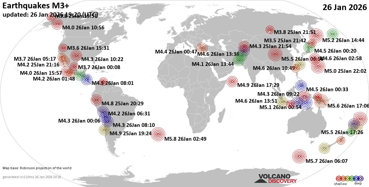 Worldwide earthquakes above magnitude 3 during the past 24 hours on 26 Jan 2026 Magnitude 5+: 15 earthquakes Magnitude 4+: 44 earthquakes Magnitude 3+: 153 earthquakes Magnitude 2+: 415 earthquakes No quakes of magnitude 6 or higher 10 largest earthquakes in the world (past 24 hours)Monday, Jan 26, 2026, at 01:49 am (GMT -1) - Monday, Jan 26, 2026, at 04:07 pm (GMT +10) - Tuesday, Jan 27, 2026, at 03:06 am (Port Moresby time) - Tuesday, Jan 27, 2026, at 06:26 am (GMT +13) - Monday, Jan 26, 2026, at 02:56 pm (Shanghai time) - Monday, Jan 26, 2026, at 04:31 pm (GMT +13) - Tuesday, Jan 27, 2026, at 12:25 am (GMT +13) - Monday, Jan 26, 2026, at 11:52 pm (GMT +13) - Tuesday, Jan 27, 2026, at 02:02 am (GMT +13) - Tuesday, Jan 27, 2026, at 01:44 am (GMT +11) - Earthquakes reported feltSunday, Jan 25, 2026, at 08:43 pm (GMT +1) - Monday, Jan 26, 2026, at 04:22 am (GMT -6) - Monday, Jan 26, 2026, at 03:47 am (GMT +3) - Monday, Jan 26, 2026, at 03:00 pm (GMT +1) - Sunday, Jan 25, 2026, at 04:24 pm (GMT -3) - Sunday, Jan 25, 2026, at 03:29 pm (GMT -5) - Monday, Jan 26, 2026, at 03:54 am (GMT +6) - Sunday, Jan 25, 2026, at 09:06 pm (GMT -3) - Monday, Jan 26, 2026, at 04:19 am (GMT -5) - Tuesday, Jan 27, 2026, at 03:06 am (Port Moresby time) - Tuesday, Jan 27, 2026, at 12:25 am (GMT +13) - Sunday, Jan 25, 2026, at 08:04 pm (GMT -8) - Earthquake stats   https://www.volcanodiscovery.com/earthquake/news/292949/World-Earthquake-Report-for-Monday-26-January-2026.html https://www.volcanodiscovery.com/earthquake/news/292949/World-Earthquake-Report-for-Monday-26-January-2026.html
0
14
Read More
|
World Earthquake Report for January 2026
Webmaster
4 hours ago
World Earthquake Report for January 2026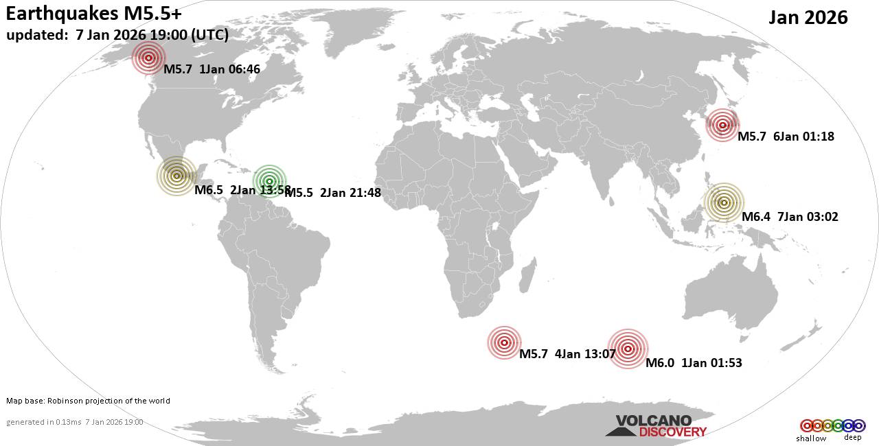 Worldwide earthquakes above magnitude 5.5 during January 2026 Magnitude 9+: none Magnitude 8+: none Magnitude 7+: none Magnitude 6+: 9 earthquakes Magnitude 5+: 145 earthquakes Magnitude 4+: 1103 earthquakes Magnitude 3+: 5148 earthquakes Magnitude 2+: 10947 earthquakes No quakes of magnitude 7 or higher List of 10 largest earthquakes in the world during January 2026:Friday, Jan 2, 2026, at 07:58 am (Mexico City time) - Wednesday, Jan 7, 2026, at 11:02 am (Manila time) - Thursday, Jan 1, 2026, at 07:53 am (GMT +6) - Saturday, Jan 3, 2026, at 04:07 pm (GMT +6) - Wednesday, Dec 31, 2025, at 11:46 pm (Whitehorse time) - Tuesday, Jan 6, 2026, at 10:18 am (GMT +9) - Sunday, Jan 4, 2026, at 04:07 pm (GMT +3) - Friday, Jan 2, 2026, at 05:48 pm (GMT -4) - Wednesday, Jan 7, 2026, at 12:12 pm (GMT +8) - Earthquake stats: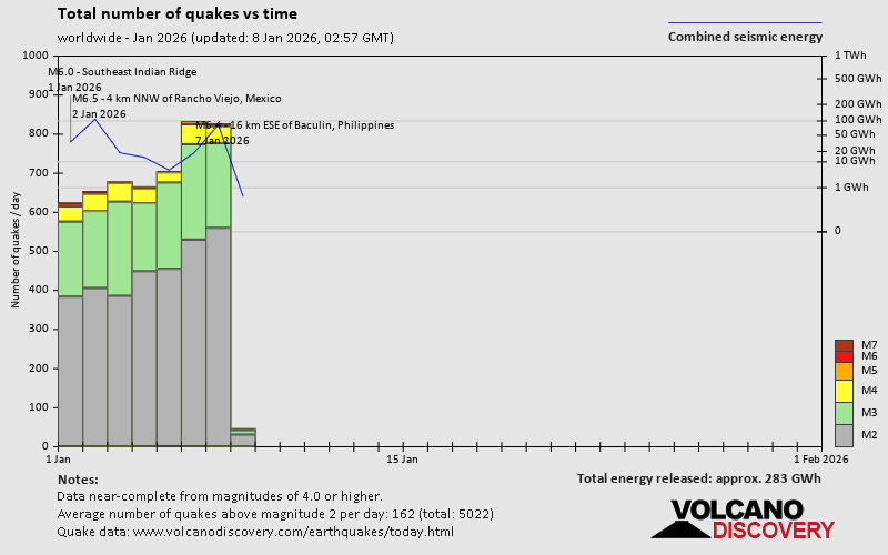 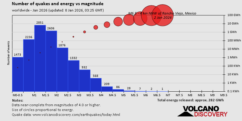 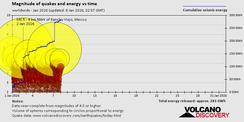 https://www.volcanodiscovery.com/view_news/290900/World-Earthquake-Report-for-January-2026.html https://www.volcanodiscovery.com/view_news/290900/World-Earthquake-Report-for-January-2026.html
0
15
Read More
|
SPC Jan 26, 2026 1930 UTC Day 3 Severe Thunderstorm Outlook
Webmaster
4 hours ago
SPC Jan 26, 2026 1930 UTC Day 3 Severe Thunderstorm OutlookSPC 1930Z Day 3 Outlook 
Day 3 Convective Outlook
NWS Storm Prediction Center Norman OK
1240 PM CST Mon Jan 26 2026

Valid 281200Z - 291200Z

...NO THUNDERSTORM AREAS FORECAST...

...SUMMARY...
Thunderstorms are not expected Wednesday.

...Synopsis...

Surface high pressure will persist beneath broad upper
troughing/northwest flow across the eastern two-thirds of the CONUS
on Wednesday. This will maintain the modified arctic airmass across
much of the country. With a large area of snow and ice cover, cold,
dry and stable conditions will preclude thunderstorm activity.

..Leitman.. 01/26/2026
Read morehttps://www.spc.noaa.gov/products/outlook/day3otlk_1930.html
0
5
Read More
|
Significant 5.6 quake hits near Mendi, Mendi-Munihu District, Southern Highlands Province, Papua New Guinea
Webmaster
6 hours ago
Significant 5.6 quake hits near Mendi, Mendi-Munihu District, Southern Highlands Province, Papua New Guinea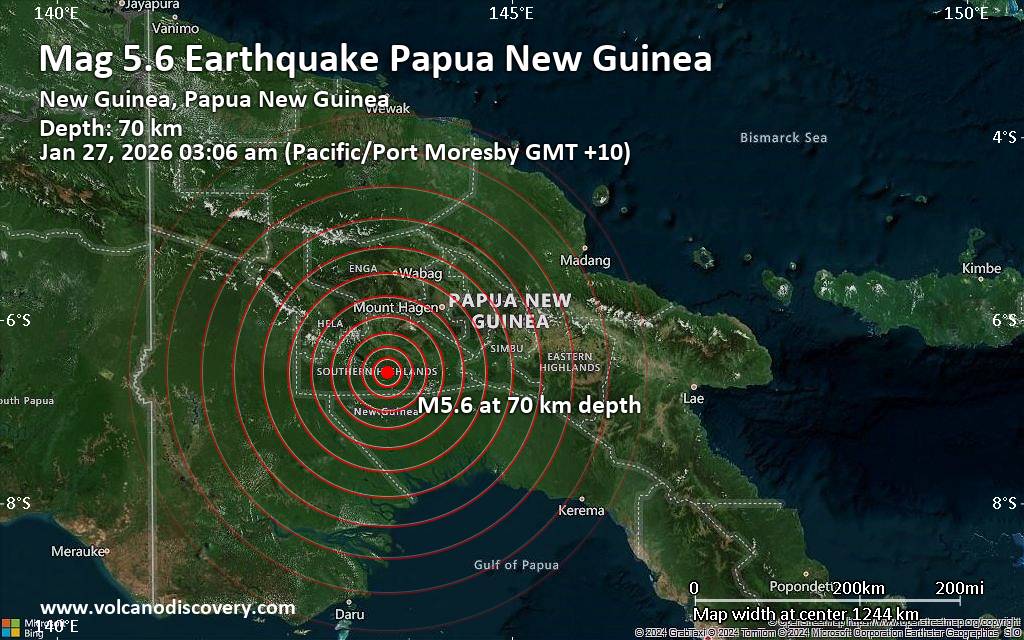 An intermediate magnitude 5.6 earthquake was reported early morning near Mendi, Mendi-Munihu District, Southern Highlands Province, Papua New Guinea.
According to Indonesia's Meteorology, Climatology, and Geophysical Agency, the quake hit on Tuesday, January 27th, 2026, at 3:06 am local time at an intermediate depth of 70. km. The exact magnitude, epicenter, and depth of the quake might be revised within the next few hours or minutes as seismologists review data and refine their calculations, or as other agencies issue their report.
A second report was later issued by the European-Mediterranean Seismological Centre (EMSC), which listed it as a magnitude 5.5 earthquake. Other agencies reporting the same quake include the German Research Centre for Geosciences (GFZ) at magnitude 5.5, and the citizen-seismograph network of RaspberryShake at magnitude 5.5.
Based on the preliminary seismic data, the quake was probably felt by many people in the area of the epicenter. It should not have caused significant damage, other than objects falling from shelves, broken windows, etc.
In Mendi (pop. 26,300) located 47 km from the epicenter, and Ialibu (pop. 6,900) 51 km away, the quake should have been felt as light shaking.
Weak shaking might have been felt in Mount Hagen (pop. 33,600) located 103 km from the epicenter, Tari (pop. 8,200) 107 km away, and Tari (pop. 8,200) 110 km away.
VolcanoDiscovery will automatically update magnitude and depth if these change and follow up if other significant news about the quake become available. If you’re in the area, please send us your experience through our reporting mechanism, either online or via our mobile app. This will help us provide more first-hand updates to anyone around the globe who wants to know more about this quake.
Earthquake data: Date & time: Jan 26, 2026 05:06 pm (Universal Time) local time (26 Jan 2026 17:06 GMT)Magnitude: 5.5 Depth: 10.00 km Epicenter latitude / longitude: 6.56°S / 143.62°E  ( Southern Highlands Province, Papua New Guinea) Primary data source: BMKGhttps://www.volcanodiscovery.com/earthquake/news/293005/Significant-56-quake-hits-near-Mendi-Mendi-Munihu-District-Southern-Highlands-Province-Papua-New-Gui.html
0
23
Read More
|
Wednesday: Light Cloud, Minimum Temperature: 3°C (38°F) Maximum Temperature: 9°C (48°F)
Webmaster
7 hours ago
Maximum Temperature: 9°C (48°F), Minimum Temperature: 3°C (38°F), Wind Direction: Easterly, Wind Speed: 6mph, Visibility: Very Good, Pressure: 993mb, Humidity: 82%, UV Risk: 2, Pollution: Low, Sunrise: 08:01 GMT, Sunset: 16:43 GMT Source: Wednesday: Light Cloud, Minimum Temperature: 3°C (38°F) Maximum Temperature: 9°C (48°F)
0
16
Read More
|
Tuesday: Heavy Rain, Minimum Temperature: 3°C (37°F) Maximum Temperature: 9°C (48°F)
Webmaster
7 hours ago
Maximum Temperature: 9°C (48°F), Minimum Temperature: 3°C (37°F), Wind Direction: South Easterly, Wind Speed: 19mph, Visibility: Moderate, Pressure: 980mb, Humidity: 83%, UV Risk: 1, Pollution: Low, Sunrise: 08:03 GMT, Sunset: 16:42 GMT Source: Tuesday: Heavy Rain, Minimum Temperature: 3°C (37°F) Maximum Temperature: 9°C (48°F)
0
17
Read More
|
Today: Light Rain, Minimum Temperature: 4°C (40°F) Maximum Temperature: 5°C (41°F)
Webmaster
7 hours ago
Maximum Temperature: 5°C (41°F), Minimum Temperature: 4°C (40°F), Wind Direction: South Easterly, Wind Speed: 9mph, Visibility: Moderate, Pressure: 999mb, Humidity: 77%, UV Risk: 1, Pollution: Low, Sunrise: 08:04 GMT, Sunset: 16:40 GMT Source: Today: Light Rain, Minimum Temperature: 4°C (40°F) Maximum Temperature: 5°C (41°F)
0
17
Read More
|
Small magnitude 3.8 quake hits 41 miles southeast of Fallon, Nevada, United States in the morning
Webmaster
7 hours ago
Small magnitude 3.8 quake hits 41 miles southeast of Fallon, Nevada, United States in the morning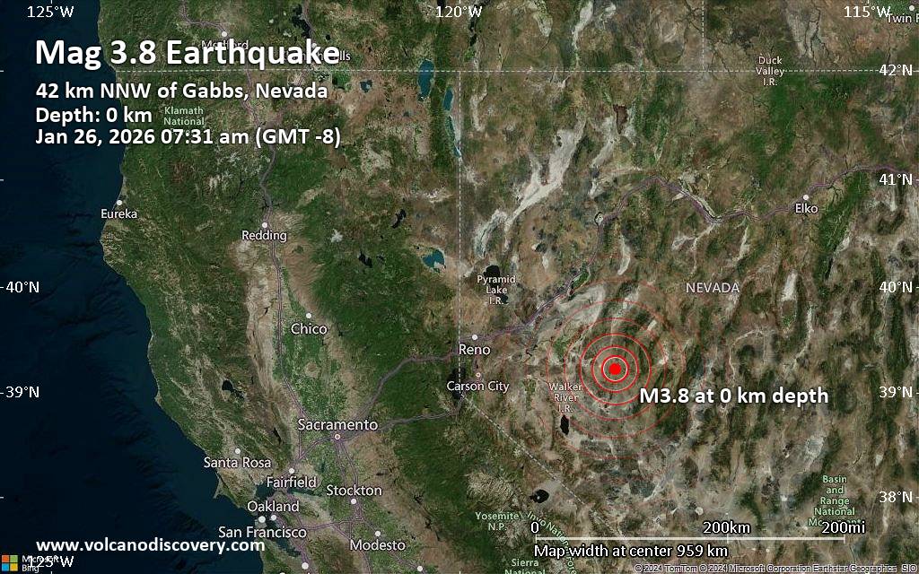 An earthquake of magnitude 3.8 occurred only 5 minutes ago 41 miles southeast of Fallon, Nevada, United States, the United States Geological Survey reported.
The quake hit at a very shallow depth of miles beneath the epicenter near Fallon, Churchill County, Nevada, USA, in the morning on Monday, January 26th, 2026, at 7:31 am local time. The exact magnitude, epicenter, and depth of the quake might be revised within the next few hours or minutes as seismologists review data and refine their calculations, or as other agencies issue their report.
A second report was later issued by the European-Mediterranean Seismological Centre (EMSC), which listed it as a magnitude 3.8 earthquake as well. A third agency, The Incorporated Research Institutions for Seismology (IRIS), reported the same quake at magnitude 3.8.
Towns or cities near the epicenter where the quake might have been felt as very weak shaking include Gabbs (pop. 270) located 26 miles from the epicenter, and Fallon (pop. 8,500) 41 miles away. In Hawthorne (pop. 3,300, 56 miles away), the quake was probably not felt.
Earthquake data: Date & time: Jan 26, 2026 07:31 am (GMT -8) local time (26 Jan 2026 15:31 GMT)Magnitude: 3.8 Depth: 0.04 km Epicenter latitude / longitude: 39.22°N / 118.09°W  ( Churchill County, Nevada, United States) Primary data source: USGShttps://www.volcanodiscovery.com/earthquake/news/293003/Small-magnitude-38-quake-hits-41-miles-southeast-of-Fallon-Nevada-United-States-in-the-morning-.html
0
10
Read More
|
Small earthquake of magnitude 3.6 reported 20 miles northwest of Anchorage, Alaska, United States
Webmaster
8 hours ago
Small earthquake of magnitude 3.6 reported 20 miles northwest of Anchorage, Alaska, United States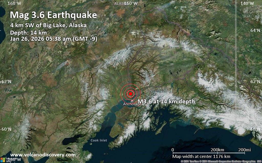 Just 34 minutes ago, a 3.6-magnitude earthquake struck near Anchorage, Alaska, USA. The tremor was recorded early morning on Monday, January 26th, 2026, at 5:38 am local time, at a shallow depth of 8.6 miles below the surface.
The event was filed by the United States Geological Survey, the first seismological agency to report it.
A second report was later issued by The Incorporated Research Institutions for Seismology (IRIS), which listed it as a magnitude 3.6 earthquake as well. A third agency, the European-Mediterranean Seismological Centre (EMSC), reported the same quake at magnitude 3.6.
Based on the preliminary seismic data, the quake should not have caused any significant damage, but was probably felt by many people as light vibration in the area of the epicenter.
Weak shaking might have been felt in Big Lake (pop. 3,400) located 3 miles from the epicenter.
Other towns or cities near the epicenter where the quake might have been felt as very weak shaking include Knik-Fairview (pop. 14,900) located 14 miles from the epicenter, Meadow Lakes (pop. 7,600) 16 miles away, Eagle River (pop. 24,800) 19 miles away, Eagle River (pop. 24,800) 19 miles away, Anchorage (pop. 289,600) 20 miles away, Wasilla (pop. 9,300) 20 miles away, Elmendorf Air Force Base (pop. 6,600) 21 miles away, Tanaina (pop. 8,200) 22 miles away, and Lakes (pop. 8,400) 25 miles away.
Earthquake data: Date & time: Jan 26, 2026 05:38 am (GMT -9) local time (26 Jan 2026 14:38 GMT)Magnitude: 3.6 Depth: 13.80 km Epicenter latitude / longitude: 61.5°N / 150.02°W ( Matanuska-Susitna Borough, Alaska, United States) Primary data source: USGShttps://www.volcanodiscovery.com/earthquake/news/293001/Small-earthquake-of-magnitude-36-reported-20-miles-northwest-of-Anchorage-Alaska-United-States.html
0
10
Read More
|
Moderate magnitude 4.6 earthquake 57 km northwest of Kefamenanu, Indonesia
Webmaster
8 hours ago
Moderate magnitude 4.6 earthquake 57 km northwest of Kefamenanu, Indonesia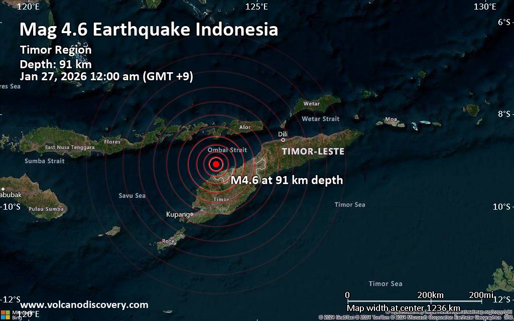 A magnitude 4.6 earthquake near Kefamenanu, North Central Timor Regency, East Nusa Tenggara, Indonesia, was reported only 9 minutes ago by Indonesia's Meteorology, Climatology, and Geophysical Agency, considered the main national agency that monitors seismic activity in Indonesia. The earthquake occurred at an intermediate depth of 91. km beneath the epicenter after midnight on Tuesday, January 27th, 2026, at 12:00 am local time. The exact magnitude, epicenter, and depth of the quake might be revised within the next few hours or minutes as seismologists review data and refine their calculations, or as other agencies issue their report.
Our monitoring service identified a second report from the citizen-seismograph network of RaspberryShake which listed the quake at magnitude 4.6 as well.
Towns or cities near the epicenter where the quake might have been felt as very weak shaking include Lifau (pop. 1,900) located 26 km from the epicenter, Kefamenanu (pop. 48,200) 57 km away, Naisano Dua (pop. 2,300) 69 km away, Atambua (pop. 82,200) 86 km away, Soe (pop. 40,200) 89 km away, Kalabahi (pop. 19,200) 107 km away, and Lewoleba (pop. 30,200) 109 km away.
VolcanoDiscovery will automatically update magnitude and depth if these change and follow up if other significant news about the quake become available. If you’re in the area, please send us your experience through our reporting mechanism, either online or via our mobile app. This will help us provide more first-hand updates to anyone around the globe who wants to know more about this quake.
Earthquake data: Date & time: Jan 26, 2026 03:00 pm (Universal Time) local time (26 Jan 2026 15:00 GMT)Magnitude: 4.6 Depth: 77.00 km Epicenter latitude / longitude: 9.04°S / 124.04°E  (Kupang Regency, East Nusa Tenggara, Timor-Leste) Primary data source: BMKGhttps://www.volcanodiscovery.com/earthquake/news/292999/Moderate-magnitude-46-earthquake-57-km-northwest-of-Kefamenanu-Indonesia.html
0
10
Read More
|
|
Forums60
Topics758,842
Posts793,556
Members2,958
| |
Most Online17,963
Jan 15th, 2026
|
|
|
|
|
Copyright 1996 - 2026 by David Cottle. Designed by David Bate Jr. All Rights Reserved.
By using this forum, the user agrees not to transfer any data or technical information received under the agreement, to any other entity without the express approval of the AUS-CITY Forum Admins and/or authors of individual posts (Forum Admins and DoD/USSPACECOM for the analysis of satellite tracking data).
Two-line elements (TLE) and all other satellite data presented and distributed via this forum and e-mail lists of AUS-CITY are distributed with permission from DoD/USSTRATCOM.


Reprise Hosting

|

|


 - Click image for larger picture.")


